Home / Real estate / Land / Cadastral registration / Cadastral number / Information about land by cadastral number
Back
Published: 07/03/2017
Reading time: 3 min
0
500
Copying a land plot is not one of the mandatory documents that the owner must have. But it may be needed when designing construction work on the ground.
- What is copying of a land plot?
- What information about a land plot can be obtained on the Rosreestr website using a public cadastral map?
- What information about a land plot can be obtained from the Unified State Register of Real Estate?
General information about copying a plot
Authors of different sources give different definitions of the concept of copying: from “summary of geodetic work” to “plan diagram with a detailed description of the land plot.” It is difficult to find an unambiguous definition on thematic resources, and a normative definition of this document simply does not exist.
Simply put, a copy of a land plot is an extract, a fragment of a general or situational plan, a copy of part of a cadastral or other plan of a settlement. The concept is derived from the word “copy”, “copy”.
The variety of topographic and cadastral documentation allows us to provide similar extracts from a huge range of geodetic documents.
To ensure access to the most complete information, an extract is issued from the general or situational plan.
Although the copy does not establish the type and scope of rights to the plot, and is not a permit or cadastral document, it gives the most complete picture of the land plot and the objects located on it and nearby. It contains graphic and text information with a decoding of symbols, an up-to-date description of the condition of objects, utility networks, road infrastructure and other information that can be obtained from the master plan.
Since, in accordance with paragraphs. 20 clause 1 art. 14, issues of land use and urban planning are within the competence of local authorities; federal or regional legislation does not provide for the possibility of issuing copies. This service is provided at the municipal level and is therefore regulated exclusively by local Administrative Regulations.
In what cases is this document required?
In my work profile I often come across this phrase. I wish I could write it correctly. Copying from the plan confuses me (from something). And copying from the plan confuses others. Although we are copying from a paper source (document). Please help me figure it out. With reference to the source
How can I make a copy myself?
1) Look at the synonym copy . We say: a copy of a painting - without any pretext at all, the analogy here requires “copying a plan”; the pretext can only be brought into the process - to make a copy from the painting - “to make a copy from the general plan.”
You can obtain a copy of the general plan from the relevant authorities at your place of residence. But to avoid unnecessary waste of time and money, it is best to contact a specialized company. will not only copy the general plan for its customers, but will also carry out all the necessary approval procedures at all levels.
Why might copying be necessary?
Given the content, copying can replace any plan necessary to obtain permits. Copying from a master plan or situational plan of a settlement is suitable for:
- preparation of a land management project for a site, development of land management proposals, preparation of pre-project documentation for the rational use of land;
- obtaining permission for capital construction;
- developing a project for individual or multi-apartment development for submission to Rosreestr;
- zoning of the territory adjacent to a residential building;
- landscape design;
- development of a project for electricity supply, water supply, gasification or connection of other utilities;
- surveying, dividing a land plot, preparing a project for the formation of one building plot from several smaller ones, and so on.
In addition, copying a land plot in SNT may be required to privatize a dacha, order a cadastral or topographic survey, and even to formalize real estate transactions in order to indicate the location of the plot in respect of which the transaction is being concluded.
Contents of the plan copy
Since the copy is a fragment of a general or situational plan, it should display everything that is contained in the version of the general plan officially approved by the municipality management.
If a section of a topographic or cadastral map is copied, the extract must be an exact copy of such a fragment.
Taking into account the requirements of the law, in particular Art. 23, the graphic part of the copy must contain:
- dividing the territory into functional zones: residential, public and business, transport, recreational;
- designation of the boundaries of land plots with the placement of development objects, red lines and other restrictive zones on them;
- local roads and other transport infrastructure facilities;
- electrical networks, water supply and drainage systems, gas supply facilities and other utilities;
- terrain, boundaries of forest areas and forest parks, reservoirs, and so on.
At the same time, the text part of the extract must contain information to decipher graphic data:
- symbols used on the copied plan;
- the scale at which the map was copied;
- description of the area of interest to the customer, indicating geodata;
- an explication listing the development objects located on the site, clarifying the technical and economic indicators: total area, building area, and so on;
- performers' contact details;
- indication of the source of information.
Copying from a document is
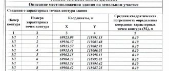
If a copy is required for connection to electrical networks, gas supply, or water supply, then it must indicate the exact position of the points where this connection can be made. To carry out legal operations with the site, a copy is made from the cadastral plan, which precisely indicates the coordinates of the turning points of the site, its boundaries and area.
Of the underground communications that have ever been carried out on the territory of the site or in its immediate vicinity: this is the diagram and characteristics of the laid sewerage system, water supply routes and other communications. It is mandatory to describe the features of this land plot - natural conditions, the presence of landslides, the depth of detection of groundwater (geodetic surveys).
Where and how to order a copy
Now it’s time to figure out where to get a copy of the land plot. Since issues of land management, land use, urban development and approval of urban planning documentation are the responsibility of the local municipal government, the only body that can prepare this document is the urban planning department/office/bureau of the local municipal administration of an urban or rural settlement.
In some regions, municipal services are provided through the MFC. This should be checked with your local administration or nearest multifunctional centre.
How to obtain an extract is determined by local administrative regulations. Typically, the procedure for providing the service is as follows (using the example of the urban settlement of Zaprudnya, Taldom district, Moscow region):
- The applicant applies to the town planning department with an application for a copy and the necessary documents.
- The application is registered within 24 hours if there are no grounds for refusal of registration.
- After reviewing the application, the head of the department makes a decision on providing the requested documents.
- Department employees check the package of documents for compliance with the regulations.
- Administration specialists prepare a copy and inform the applicant of its readiness.
- The applicant receives the requested documents. The waiting period cannot exceed 20-30 days.
As a rule, the service is provided free of charge, although it cannot be excluded that in some municipalities a fee may be charged.
The administrative regulations establish a list of reasons why a customer may be denied a copy. These include:
- identification of unreliable, false, fake information about the applicant;
- failure to provide a complete package of documents;
- requesting information that is not contained in the general or situational plan.
The applicant has the right to appeal an unfounded refusal. In addition, a complaint can be filed in case of non-compliance with the deadlines for preparing a document, a requirement to provide documents not provided for by regulations, and in other cases of unlawful behavior of administration employees.
Usually the applicant is notified of the readiness of the copy by telephone or by mail to the address specified in the application.
If you need more detailed information about the land plot, and not just a map of the area, you can request it from the real estate cadastre.
Read more about how to do this in the material “State Land Cadastre”.
What information about a land plot can be obtained from the Unified State Register of Real Estate?
In 2021, Federal Law No. 218 on state registration of real estate came into force, which is aimed at combining all available information about real estate (including plots of land) into a single Unified State Register document. This will eliminate the possibility of fraudulent activities, since all information, including title data for real estate objects, will be available for verification in one information database.
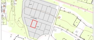
EGRN contains technical, cartographic, legal and title information about land plots. In the special section “Description of the location of the land plot” there is a plan or diagram of the land plot.
If you want to find out how to solve your particular problem, please contact us through the online consultant form or call :
An extract from the Unified State Register is provided in several versions: in the form of a paper or electronic document. To receive it, you must contact the territorial office of Rosreestr, send a request through the MFC, Russian Post or online using Rosreestr’s electronic services. The document is provided if there is an application from the owner with the attachment of his passport, SNILS, title documentation and a power of attorney to represent interests (if the document is submitted remotely). When filling out the application, you must indicate the cadastral number of the plot.
The extract can be sent to the applicant by mail, in the format of a link to an email address, or he will need to personally visit the department to pick up the document.
If you need to obtain not just a schematic layout of a land plot, but a system plan (copy) at the request of Rosreestr or other government agencies, you will need to additionally contact the territorial department of architecture at the location of the land plot along with an extract from the Unified State Register of Real Estate, a certificate of ownership and a passport. After all, only here will the nearest objects of resource significance, power lines, pipelines, potentially dangerous objects, etc. be indicated.
Or on the website. It's fast and free!
Application and package of documents
An interested person who wishes to make a copy must send an application to the town planning department. If the form is not approved by the appendix to the specified Administrative Regulations, the application for copying a land plot is drawn up arbitrarily. In any case, it must contain:
- name of the municipal body and official to whose name the application is sent;
- the name and contact details of the applicant;
- a request to issue an extract from the plan in relation to a specific site indicating the address or other landmarks;
- the purposes for which the document is requested;
- list of attached documents;
- date, signature.
We invite you to familiarize yourself with a sample of such a statement.
The application must be accompanied by a package of documents established by local regulations. As a rule, these include:
- a copy of a passport or other identity document;
- cadastral plan of the site;
- cadastral passport for the plot;
- certificate of state registration / extract from the Unified State Register of Real Estate, other title documents;
- registration certificate for buildings located on the land plot.
All documents must be submitted in copies with the simultaneous presentation of originals, which an administration employee will check for consistency with each other.
How to obtain a territory plan from the MFC?
You can order boiling at any Multifunctional Center, for this you will need:
- come to the center in person and take a ticket to the queue;
- at the reception window, fill out applications based on documents (owner’s passport, cadastral number of the plot, land ownership certificate);
- receive an application for admission indicating the time of receipt of the scheme;
- come get the diagram.
Is it possible to order an extract online?
If you are researching the question of how to make a copy of a plot of land via the Internet, you need to understand that everything depends on the locality, the administrative regulations adopted there and the technological possibility of remotely providing extracts.
For example, in the Zaprudnya settlement you can request such a document in person or by mail. And on the territory of the Butrakhtinsky village council of the Tashtyp district of the Republic of Khakassia, it is possible to request a copy online - for this you need to use the administration website.
In some regions and municipalities, the service is provided through. To find out whether a statement can be ordered online, the applicant must:
- go to the municipal administration website;
- visit the local version of the State Services website.
The legislative framework
The main regulations that are directly related to the registration of copies are considered to be:
- Decree of the President of Russia “Concerning the approval of a list of confidential information”;
- Federal law that guarantees the protection of personal data;
- Town Planning Code of the Russian Federation - reflects various nuances that may arise during the period of registration of the copy;
- Federal Law “On the General Principles of Organization of Local Self-Government on the Territory of Russia,” which reflects the registration procedure and procedure for authorized persons in providing services to the population.
The specified list of regulations is not exhaustive, however, it contains general design principles and nuances that may arise during the preparation of the copy.
What does copying look like?
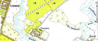
A copy is an exact fragment of a general, situational, topographical or other plan, so it should look the same as this plan. It can be color or black and white, have different scales and symbols, different functional zones and composition, but will always be made in the form of a topographic map of the area depicting land plots, their boundaries and objects located around them.
We offer you to look at a sample copy from the general and situational plan of the area. For a complete understanding, fragments made for different purposes are taken.
What is a situational plan and why is it needed?
The generally accepted definition of a situational plan is a topographical diagram of a land plot with all its boundaries. It must be carried out on such a scale as to give an idea of the roads, infrastructure, and other objects surrounding the site, as well as the development of the site itself. A typical topographic map for creating a situation plan has a scale of 1:2000, most areas are presented at the same scale or at a larger scale. For areas of large area, it is possible to create a plan at a scale of 1:5000, in which case it is tied to the north-south direction to simplify orientation.
The main requirement for situational plans is information content. It should be sufficient for the development of engineering and architectural projects. Not only the boundaries of existing buildings are marked, but also the lines of protected areas and sanitary zones. All structures, infrastructure and communications are marked with generally accepted symbols that give a complete picture of the site and surroundings.
We recommend reading: What is expected for 4 children in 2021 in the Moscow region
Other documents for land
Owners of land plots should remember that in addition to copying in relation to their allotment, there is a lot of other documentation that forms the land management file. It is stored in the territorial division of Rosreestr and includes:
- boundary and cadastral plan of the site boundaries;
- extract from the Unified State Register and other title documents;
- acts of approval of the boundaries of a land plot;
- description of the coordinates of boundary signs;
- extracts from territorial planning documents;
- extracts from land use and development rules;
- extracts from state cartographic and geodetic funds;
- other documents obtained as a result of land management.
For more information about how this package is maintained and formed, read the material “Land Management.”
What is the price?
- request for a copy;
- signature of the applicants or an authorized representative.
- date of compilation;
- name of the local authority to which the application is submitted;
- initials of the authorized person;
- applicant's full initials;
How to make a copy of a plot of land via the Internet
A copy of an inheritance is a color or black and white plan on a certain scale. It comes with A4 paper. Including symbols on the map, scale, initials of the map maker, date and signature. The document is drawn up in form F-4 and is attached to the card.
We recommend reading: Harmful working conditions article
Owners of land plots should remember that in addition to copying in relation to their allotment, there is a lot of other documentation that forms the land management file. It is stored in the territorial division of Rosreestr and includes:
A registration certificate is issued for a fee, the cost can be clarified at the local BTI. The passport will be produced within one to two weeks, but for an additional fee you can order urgent production, which will take several days.
Reasons for refusal to provide data
Before carrying out engineering work within the land plot (construction, reconstruction, major repairs), you will need to copy it - a topographic plan, with basic data about the site. Engineering and surveying can prepare a high-quality copy, as well as conduct engineering and geodetic surveys for construction in a short time.
When registering official real estate, there is a procedure for assigning a cadastre number. The state allocates land and assigns an individual number to the plot, after which it can become the object of a transaction. Using this identifier, you can obtain extensive information about the object:
- To create a technical specification.
- For electrical connection. Otherwise, without it, the power supply service will not accurately indicate the location of the poles and exits. This is required for services at go-live.
- When purchasing the necessary papers for development from the urban planning department.
How to make a copy of a plot of land yourself
The floor drawing is too voluminous and therefore quite small. It is quite difficult to examine anything in detail. The layout of a particular apartment can only be guessed approximately on the floor plan. Copying allows you to enlarge a specific area.
A copy of a land plot is a plan or diagram, which is the result of geodetic work, with a deciphering of all marked symbols. In this document you can find all the information of a geographical and technical nature regarding a specific plot, as well as the state of the area and various objects.