Registry error - incorrect display of USRN information due to incorrect survey of the house by a surveyor or analysis of office data by a cadastral engineer. The registry error is contained precisely in the calculations. It does not occur when transferring data from one database to another, unlike a technical error.
Most often, registry errors regarding a house appear in the location of the boundaries and area of the building.
What mistakes are often made
The definition of cadastral violations is reflected in the law issued at the federal level in 2007 under No. 221. It means any defect in the documentation. It is considered as a basis for making adjustments to the information contained in the Unified State Register of Real Estate. For example, it could be a technical error. If an engineer incorrectly reflects the lines of the site and its coordinates in important papers, then this will be considered as a cadastral error.
Quite common violations are:
- the use of equipment that is considered obsolete, while activities are carried out without taking into account the coordinates assigned to the state;
- implementation of tasks without visiting the plot, then the plan reflects approximate values;
- information is taken from lands located nearby that were previously registered;
- The official has low qualifications.
As a result, allotment lines are determined where there is no reference to a specific area. In addition, the reason for the inaccuracy is that the BTI employees did not show due care during the work or there was a malfunction of the equipment used. Regardless of why the inaccuracy occurred, it must be corrected. A registration error means that the owner of the plot will not have the opportunity to register the plot. It will also not be possible to reflect the necessary data during registration or deregister a specific site when it is terminated.
IMPORTANT !!! Inaccuracies will not allow property rights to be formalized, which is reflected in the legislation after the latest amendments have been made to it. In addition, the owner of the plot must understand that he will not pay an inflated amount of government fees and taxes if the documentation contains errors.
In the event that the category of use of the allotment is incorrectly determined, the citizen loses the right to use the allotment at his own discretion. We are talking about how to obtain permission for construction work, approval of a mortgage loan, etc. In the situation under consideration, there is a high probability that disputes over land will arise between persons owning neighboring plots. In addition, difficulties relate to transactions for the purchase and sale of plots.
What methods exist to correct errors in cadastre documentation?
There are two ways to correct technical and registry errors: judicial and extrajudicial.
The extrajudicial method is used if making adjustments will not entail infringement of the rights of the land owner or other persons (for example, owners of neighboring plots). The procedure varies depending on the type of error.
To correct calculation, grammatical inaccuracies, typos and typos (technical errors) made by an employee of Rosreestr during cadastral registration, a decision of the state registrar is required.
The basis for its issuance is:
- detection of an error by an employee of the Registration Chamber itself;
- application from the owner or other person having an interest in this land plot;
- judge's decision to make adjustments to cadastral documents.
Correction of inaccuracies
When talking about how to fix an error, you need to understand in what order this happens. Another important question will be at whose expense the violation will be corrected. If a BTI employee makes a mistake, a decision must be made regarding its elimination. It reflects when a violation was identified and an explanation of what type of inaccuracy belongs to and what caused its formation. The next day after determining the presence of violations, the cadastral organization sends documentation to citizens who are interested in it. In addition, information must be sent to the authorities that will take part in correcting inaccuracies.
ATTENTION !!! The process of correcting an official's mistakes legally involves the use of several options. In particular, this is a similar sequence of actions that is used when data is reflected in the Unified State Register of Real Estate. This applies to a situation where you need to change information written in the registry. In this case, it is necessary for the owner to draw up a statement and official documentation, which becomes the basis for reflecting certain corrections.
The second method is represented by the fact that the order of information interaction is used. This applies to organizations with a specific interest. The third option is a decision made by a court. The basis for the formation is an authorized organization or person.
If we consider this issue from the financial side, then the first couple of methods will be cheaper. An appeal to the court is required when the registry organization refuses an accounting operation due to shortcomings in the cadastre. Responsibility in this situation rests with the person carrying out the cadastral work. In addition, the application generated by the owner of the site is rejected by the USNR. The owner may also have a conclusion issued by a cadastral engineer regarding the correction of the violation. This applies to errors made during boundary work on this site or adjacent to it.
At what stage of construction can errors occur?
Errors become registered after entering incorrect data into the Unified State Register, but incorrect information can be noticed much earlier:
- when preparing design documentation (the technical plan can be prepared on the basis of data from the design documentation; the designers’ mistake sometimes goes as far as submitting the technical plan to Rosreestr);
- during geodetic survey of a building (surveying is carried out after completion of construction; an error may occur due to incorrectly configured instruments);
- when a cadastral engineer processes data (geodetic data is incorrectly interpreted, work in a computer program is configured);
- when preparing a technical plan and submitting it for registration (incorrect data was entered into the boundary plan, which was duplicated in Rosreestr).
All errors that may occur further at the stage of transferring information to the Unified State Register by employees of Rosreestr or MFC are technical and are eliminated without correcting the technical plan or other documentation at the request of the interested party
Correction if there is a statement from the owner
To eliminate violations within the boundaries of a site, judicial practice indicates that the owner often forms an application and sends it to the Unified State Register of Real Estate or a multifunctional center. The application is drawn up in a certain form. It is reflected in the order of the Ministry of Economic Development, issued in 2009 under No. 125. It is possible to send the document in person or using the State Services portal. In this situation, the amount of the state fee is not subject to collection. An additional measure is that you will need to attach to the application all documents that indicate the presence of errors. Including, these are boundary plans, acts regarding the survey of the allotment, etc. The legislation reflects the period during which the submitted application is considered. Regardless of whether the decision is positive or negative, it is made within 5 days. The countdown begins from the moment of submission.
After the decision is formed, the next day it must be sent to the applicant’s email or postal address. In any case, the owner of the plot must receive a copy of the decision and cadastral documentation with the changes made, if the answer is yes. It is worth considering that when the decision is negative, no response will be sent to the owner. When a citizen is not satisfied with the verdict, he has the opportunity to appeal the act. This can be done by contacting a judicial authority. It should be noted that a negative decision can be appealed by both the owner and the applicant. Only those who have the rights of ownership of the allotment have the right to challenge the positive.
Miscellaneous → In the grip of a cadastral error
What to do if a farmer’s field covers a village or a personal plot goes to a neighbor
At the beginning of April, the editorial office of the newspaper “Peasant” hosted a round table dedicated to new challenges of land reform. A heated discussion arose over the problem of cadastral error, which, as one of the speakers put it, has become global in nature. This is how Aleksey Nikolaevich Kochetkov, head of the Rodionovo-Nesvetaysky branch of the Rostov Regional Bar Association named after. D.P. Baranova.
The speech of an experienced lawyer in the field of land relations aroused keen interest among those present. Alexey Nikolaevich kindly agreed to answer our correspondent’s questions.
– Alexey Nikolaevich, at the round table in the editorial office of “Peasant” you said that the problem of cadastral errors is global in nature. Please clarify what you mean?
– Firstly, this problem is man-made, and it was created mainly before 2008. Secondly, we are currently dealing with its consequences, and their scale has not yet been fully identified. That is why cadastral registration is still far from complete.
– In the country as a whole?
- Of course. Colleagues call me from everywhere. Now Muscovites are consulting with me on issues of cadastral errors. The problem is developing and aggravating with land plots that were and were not registered in the cadastral register in previous decades.
– Cadastral errors accumulated, but for the time being they did not interfere with the registration of new plots. Why?
– There were white spots (free spaces) on the cadastral maps. The land survey was of a declarative nature. The person turned to the cadastral engineer, and he suggested: let’s simplify the land surveying procedure, you still know the boundaries of your land plot. As a result, the land survey was not formed as it should be, and the plot was initially registered with a cadastral error.
– It turns out that the problem was created by land owners and cadastral engineers?
– I believe that the most guilty are the controlling authorities, those who accepted documents without proper verification, put a plot with a cadastral error on the cadastral register and registered it. Please note that the problem of cadastral error has affected mainly rural areas. Because a person living in a farm or village is completely occupied with his farming and survival. He trusts the cadastral engineer and does not imagine what the consequences of agreeing with him might be...
– Well, the cadastral engineer didn’t always strive to simplify land surveying?
– Of course... Errors also occurred due to the unpreparedness of the cadastral engineers themselves. In addition, there was no special universal computer system yet. They didn't work online. Everyone had their own program.
– Does this mean that during subsequent land surveys the previous results were practically not taken into account?
– Yes, there was no public cadastral map then. Each cadastral engineer created his own base. The Land Committee was abolished, and its functions disappeared along with it. Neither the cadastral service nor the justice system, later Rosreestr, became the legal successors of the land committee. For example, Rosreestr has repeatedly stated that it is not the legal successor of the land committee. They say that we only have a register for issuing certificates of ownership. Land surveying, coordinates, borders and the like are not for us. And to whom? Unknown. That is why the problem of cadastral error is global.
- How did this happen?
– Let’s say that in 2002, a cadastral engineer marked off the first section of the street. I established its coordinates as best I could, based on the information and instruments that were available at that time. Those devices had a significant error of 20-30 cm to the side. The plot was registered in the cadastral register - with a shift to the neighbor. The neighbor came to the same cadastral engineer. He demarcated its area with a reference from the shifted coordinates. The shift has already amounted to 40-60 cm. And so on. And in the end, the plots of land moved off the street and were superimposed in any way and on anything. It’s clear that the cadastral engineer is unscrupulous, but where is the control? If you look at a photographic map of houses and fences, you will see that the lot lines are shifted and mixed up haphazardly. This means that each cadastral engineer did not correct his own mistake or the mistake of a colleague, but simply placed a plot on any free space. Sometimes even in parts to different places.
– Didn’t the law provide for the responsibility of cadastral engineers?
- No, I didn’t. Only after changes were made to the law did it become possible to deprive a cadastral engineer of accreditation. Three times they refused to register your land surveying affairs - you are no longer a cadastral engineer. Since that moment (after 2010), the number of cadastral errors has noticeably decreased.
– What cadastral error are you currently dealing with?
“I’m currently working on a case regarding the situation in the Persianovka village. In a farm, not a single owner of a personal plot can register it with the cadastral register and register it with Rosreestr. Because the farmer's field completely covered the farm. This is an obvious cadastral error. If agricultural land covers a populated area, the Cadastral Chamber, by law, can put the plots in their places, regardless of overlaps and intersections, but for some reason it doesn’t do this...
- What about the farmer?
– He himself did not know about the imposition of his field. He found out when indignant farmers came to him. The farmer's plot is located 2 km from the farm. The boundary work was done back in 2005. The farmer was working calmly, and suddenly there was a surprise. Now Rosreestr employees are testifying in court. They say that in 2008, due to a change in the program and the introduction of a unified network, when they began to locate plots according to the coordinates indicated in their survey files, an overlap resulted. Either the instruments failed, or the cadastral engineers failed, but not us...
– People complain that the courts do not recognize the facts of cadastral errors. What is behind this?
– Situations are different. The court's decision may be influenced by an unfair examination. And the judge became her hostage. He has no reason to order another examination, since the necessary information is missing. The judge is forced to make a decision, even seeing on the map that this is not so. But in general we have no right to talk about such a topic. In each case, specifics are important.
– Have you encountered complex cadastral errors in your practice?
– There were even paradoxical...
- Tell me.
– Farmer Dunin has been cultivating a plot of common land since 1992. When he suddenly receives a claim to recover from him unjust enrichment and lost profits for the last three years in the amount of a six-figure sum. The farmer is terrified! How so! Here is my certificate, the resolution of the head of the district, the agreement and other documents. What kind of lawsuit? Where? It turned out that the head of the district issued a resolution on the formation of a municipal land plot. The cadastral engineer prepared a survey document in accordance with this decree, which clearly stated the location of the site: 100 meters northwest of the Plotoivanovka farmstead. And the land plot was registered for cadastral registration 100 meters southeast of the farmstead and the plot was covered with the field of farmer Dunin. After which the district administration leased the municipal land to a gentleman from Rostov. He saw that a farmer was working on the site, but remained silent. This gentleman, as a tenant, carefully paid the rent to the district administration and waited. And three years later he filed a lawsuit against the farmer as if he was illegally using the leased land. Rosreestr did not give us documents for a long time, citing the fact that they are not legal successors and they do not have primary documentation. But the court granted our petition and demanded all the documents. It turned out that everything was there. The head of the Rosreestr department brought a cadastral map with primary documentation to the court hearing. And it became clear that the municipal plot was put on cadastral registration on the common land of the farmer.
– Was there a white spot on the public cadastral map?
“There was a stain, but that’s not the point.” The land survey of the farm plot was completed before 2000. According to the law, the Cadastral Chamber and Rosreestr were required to register and register such plots automatically. But they ignored the requirement of the law.
– And created a situation related to the possibility of fraud?
– There is a borderline situation here. The scheme involves fraud, but it is impossible to prove intent unless the master himself confesses. Therefore, there is no criminal element here. However, there is such a legal concept as unfair conduct. The author of the claim took advantage of the situation and behaved in bad faith.
– Land owners, for obvious reasons, do not want to pay to correct the cadastral error. After all, the mistake is not their fault...
- This is the wrong position. Pay the expert the required amount, and he will give you an adequate conclusion. It will establish all coordinate points and identify discrepancies. And you will go to court with a ready-made conclusion.
- Without an expert?
– All land disputes are resolved only in court. Therefore, a specialist opinion is necessary. But not always. If two sides are arguing, then, in principle, an agreement can be reached. I usually suggest that neighbors invite a cadastral engineer. He will look at the land surveying and say: yours should be like this, and yours should be like that. And by mutual agreement he will correct the boundary matters. Naturally, for a fee. But without an expert and, possibly, without a trial. The one who made it is obliged to correct the mistake free of charge.
– If the street is askew, what should we do?
– Practice shows that the street does not want and cannot negotiate. And the law in this case does not give the cadastral engineer and the Cadastral Chamber the right to independently eliminate cadastral errors associated with changes in boundaries. Only the court.
– How important is an expert’s opinion for the court?
– When the cadastral error is obvious and there is no dispute, then it is not necessary. The conclusion of a cadastral engineer is sufficient. The difficulty is to identify a cadastral error, but proving it is already a process. Then procedural law applies...
– For villagers, the procedural component of the problem of recognizing and correcting a cadastral error is beyond their perception. They don’t understand it and don’t take it into account in their attempts to achieve results...
“The villagers don’t need to understand.” They just need to come for a consultation. We provide free consultations for certain categories of people. These are pensioners, disabled people, participants of the Second World War and combat operations, minors, and the poor (those with income below the subsistence level). Two lawyers, Andrei Ivanovich Renin and Pyotr Grigorievich Morozov, provide free services to such clients.
– You said at the round table that there are only three strong experts in the Rostov region. Who are they?
– I don’t want to advertise them.
– May I know how many experts we have in general?
– There are many experts, but I only work with three organizations. This is how my judicial practice developed for 10 years. The courts, as a rule, accept their conclusions.
– Who is an expert? Something like a cadastral engineer?
- No. This is a person with special knowledge. He is licensed and accredited. It operates in one of the organizational and legal forms, for example LLC.
– How to find an expert?
- Different ways. Easier via the Internet. You type a request for a specialist in cadastral work. Everyone has their own website. Then you type reviews about it in a search engine. Next is your choice of one of them, a specific expert. Of course, there is also a state expert institution...
– Is this in Rostov on Lenin Street?
– Yes, but I don’t go there, they are very busy, you have to wait at least six months. Although all courts believe them. If in a legal dispute two non-state experts provide opposing conclusions, the court appoints an examination in a state organization.
– Here is the owner of a land plot complaining: he contacted cadastral engineers several times. I paid every time, but to no avail. What's wrong with this?
– You need to contact the cadastral engineer once. He must establish the fact of a cadastral error, and that’s all. That is, a discrepancy between the survey data, the public cadastral map and the real location of the site. Next, its owner needs to come to us with documents. We study the materials and determine who made the mistake. It happens that in land surveying matters the coordinate points are indicated correctly. They correspond to points on the ground, but do not correspond to the boundaries marked on the cadastral map. The points on the map are shifted. This is a mistake by the Cadastral Chamber. The engineer of the Cadastral Chamber, who transferred the coordinates from the boundary plan to the map, made a mistake. The owner's right was violated by the Cadastral Chamber. In this case, we contact the Cadastral Chamber so that it itself changes the coordinates and eliminates the mistake.
– What if the answer is no?
– The owner of the plot can file an administrative claim against the cadastral chamber. The court will oblige her to make changes to the cadastral map. If the Cadastral Chamber tries to challenge the conclusion of the cadastral engineer, then the word is up to the expert. The variety of cadastral errors is great, and each case must be approached individually.
– Have you encountered a dead-end cadastral error? What about a problem that has no solution?
– If legal relations arise, there can be no dead-end mistakes. But there are unique ones. This one, for example. A certain woman once bought a plot of land in Rodionovo-Nesvetaiskaya Sloboda and put it on the cadastral register without defining boundaries. In the past, rural administrations often registered plots in such a way as to collect taxes. On the map such an area was simply marked with a dot. Later, the same administration provided disabled M.G. Stepanenko municipal plot for housing construction. Margarita Georgievna registered the land plot, signed a lease agreement, paid the rent, but was unable to start construction. As it turned out, the owner of the “point” then carried out land surveying and her plot was partially wedged into Stepanenko’s land plot. A land dispute arose. The woman contacted the Cadastral Chamber, and its specialists made an unfair conclusion. The head of the administration could solve the problem simply: on the basis of a letter from the Cadastral Chamber, make changes to the previous resolution to the boundaries of the Stepanenko site. Even if Margarita Georgievna had two hundred square meters less, it doesn’t matter to her. Instead, the head of the administration canceled the resolution approving the scheme for Stepanenko’s land plot. And the day before the trial. Moreover, in his decision to cancel the approval of the site plan, the head of the administration indicated that it comes into force from the moment it is signed. And these are dishonest actions. This document can only come into force from the moment of its publication. Thus, the head of the administration deprived Stepanenko of the right to appeal the unfair decision. The next day, on the basis of this ruling, the court excluded information about Margarita Georgievna’s plot from Rosreestr, including information about the concluded lease agreement. But the contract itself was not invalidated. The result is a unique situation. There is a valid lease agreement with its payment, but the subject of the agreement, that is, the land plot, is not. Stepanenko, having learned that her plot had been taken away from her, died in the hospital. This is one of the most difficult cases of cadastral error. An attempt to give a legal appearance to illegal actions. I'll go all the way to the Supreme Court.
EGRN initiative to correct
The engineer's conclusion may be corrected at the initiative of the registry. This occurs in a situation where the authorized body independently detects the presence of errors. A separate procedure for making adjustments applies. Within five days from the moment the defects are discovered, a decision is made regarding changes to the documentation. Based on this act, the registers are corrected. The citizen who owns the plot is sent a decision and a corrected version of the cadastral documentation. The paper can be sent using postal services or email.
If the owner is against such a decision, he can challenge the process by going to court. In such a situation, no additional financial expenses are provided for the property owner. The defect is fully identified and subject to correction by USRN employees. The owner is not invited to participate. When he is dissatisfied, further proceedings on this matter begin. It is fraught with expenses for legal fees.
Pre-trial procedure and necessary documents
An administrative solution to the issue is possible if the owners whose plot boundaries intersect peacefully agree on the issue among themselves.
Cadastral engineers can only make changes to the information about the boundaries, provided that they do not change the area of the plots.
Also, correction of a cadastral error of a previously registered land plot, that is, a plot for which the rights arose and were not terminated before March 1, 2008, is possible on the basis of the conclusion of a cadastral engineer.
Registry errors
By application without trial
Since most often the overlap of the plan of one land plot on another is associated with a registry (cadastral) error, the omission can be corrected in the order of accounting for changes.
To do this, you should draw up a correct boundary plan and send an application for amendments to the CMO.
On the initiative of the cadastral authority
If the fact of erroneous entry of data was established by the Registrar during information interaction, then the CMO can independently make changes to the register and notify the owners of those plots affected by the corrections.
Deadlines
Corrections based on the decision of the state registrar are carried out within 5 working days from the receipt of all necessary information about the nature of the error and how to eliminate it.
Technical errors
Correction of a technical error in cadastral information is carried out by the registration authority within three days from the moment it is identified or an interested person submits a corresponding application.
Then, within three working days, the Registrar notifies all owners of the fact of making changes.
If correction of an error involves a change in the owner of the plot, then such an amendment can only be made by court decision.
Documentation
Justification for the error
If, during cadastral work to clarify the location of the boundaries of a site, a specialist identified a cadastral error, then this information can serve as justification for making changes to the Unified State Register of Real Estate database.
The fact can be recorded in a specialist’s report.
Conclusion of the cadastral engineer:
Statement
An application requesting changes due to a technical or registry error is drawn up in accordance with Order No. 920 of the Ministry of Economic Development of the Russian Federation.
The application form is presented below:
Application form for correction of a technical error in the Unified State Register of Real Estate for entering information (P 920 12/08/2015)
Certificate of approval
This document confirms in writing the consent of the parties (for example, neighbors) to actually change the data on the boundaries of the site.
It looks like this:
Land survey plan
This comprehensive document records new data (for example, information about changes or clarification of site boundaries), which will need to be reported to the regulatory authority to correct the error.
The document form is presented below:
Is it necessary to contact Rosreestr after making corrections to the State Property Committee?
Since January 1, 2021, new amendments have appeared in the land legislation: the State Property Committee and the Unified State Register are being merged into the Unified State Register, and therefore there is no longer a need to notify one authority when there are changes in documents to another; now everything happens centrally.
Find out from our material how to register a plot of land as your property. Where and how to issue a deed of gift for an apartment? Read here.
Are changes required to the cadastre after redevelopment? See here.
Court decision to change papers
Controversial situations arising in this area require recourse to the arbitration court system for resolution. This is due to the fact that the organization will act as a defendant. After the judicial authority forms a decision, it must be sent to the Unified State Register of Real Estate, where it is executed. Employees of this body are responsible for the execution of the decision of the judicial body. If, due to certain circumstances, the paper did not reach the Unified State Register, then the owner has the right to receive a copy and formulate a statement regarding the correction of the defect that has arisen. It is worth noting that the decision must be certified by a court employee.
IMPORTANT !!! The decision of the judicial authority must clearly reflect what point should be changed. In addition, the period during which corrections are made is subject to reflection. If the period is not reflected, then the standard period is applied, it is equal to 5 days. Only those days that are working days are taken into account. If, after the EGRN employees received the decision, they did not begin to correct it, the owner has the opportunity to solve the problem in 2 ways.
Including, write an application to the court and ask to issue a writ of execution or transfer the previously formed decision to the bailiffs so that the enforcement procedure can be initiated.
If the second option is chosen, then the process of execution of the decision will be supervised by FSSP employees. It is possible to write an application to a judicial organization and ask to apply a penalty for failure to comply with the decision. Such an application is subject to separate consideration. A fine of up to one hundred thousand rubles is applied to guilty persons. If, after applying the sanction, the court act is not accepted for execution, you need to contact the FSSP inquiry department and write a statement. It states that the organization is maliciously evading the execution of a judicial act.
A citizen has certain costs, which include a lawyer’s fee for participation in the process, in addition, a state fee must be paid. It is worth pointing out that the plaintiff can independently defend his rights at the meeting. However, the complexity of the category of cases under consideration indicates that the assistance of a professional lawyer is necessary to achieve success.
How do experts make cadastral errors?
More often than not, it is the engineer who is to blame for the mistake. Today, thanks to new technologies, it is quite difficult to make a cadastral error. But it still happens, and there are several reasons for this:
- If a specialist has little experience in his field, and he simply cannot properly prepare the equipment for work, then the measurements will be incorrect. Moreover, this can be either a small mistake or serious miscalculations.
- “Old-school” specialists use an outdated coordinate system and old equipment. The result of such work may be a site that simply cannot be tied to the terrain.
- Occasionally, errors occur due to the engineer’s simple inattention.
- Sometimes, if an engineer is busy, he does not go to the site, but takes approximate coordinates for work. Of course, it is impossible to obtain the most accurate result from them.
Another culprit for the error may be local governments. When inventorying and revising documents, they may make any changes to the data that may not fully reflect the actual characteristics of the land plot.
If the owner is against
Not in all cases, decisions made by judicial authorities or employees of the Unified State Register of Real Estate are considered as benefits for the owner of the plot. In this case, citizens say that they are against correcting these inaccuracies. In practice, sometimes it happens that the owner does not agree with the introduction of adjustments. The reason for this may be that the initial information in the documentation was beneficial for him. For example, when changes concern the permitted use of the plot. Then the value of the plot increases, the owner begins to pay more taxes.
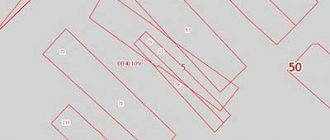
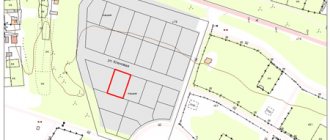
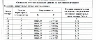
An example of a boundary plan for correcting a cadastral error
The exact type of boundary plan depends on the characteristics of the cadastral error. In this case, the document can also be submitted electronically. Here is an example of an interplane after clarifying the boundaries: