Why and when should it be done?
Land surveying determines the exact location of the site on the ground, its area and boundaries. From 2021, all land transactions are possible only after the boundaries of the plot have been accurately determined and included in the cadastre.
Defining boundaries makes it possible to:
- enter into agreements of purchase and sale, exchange, donation;
- leave a plot as an inheritance;
- rent out land;
- register ownership (if it has not been registered);
- allocate shares in the allotment (for example, by heirs);
- avoid claims from neighbors in the future who decide to appropriate the land for themselves.
Land surveying will help you easily register the built house, since the site will already be registered in the cadastral register. Thanks to the definition of boundaries, the landowner will have the opportunity to increase the area of his land within the established norm, if there is free land.
Important: Having completed the documents, you do not have to worry about the seizure of the plot or part of it by third parties and subsequent lawsuits. The initiative to cut out and develop a site can be taken not only by neighbors, but also, for example, by government agencies that are developing the area.
Act of taking out in kind
One of the most important documents as part of a land survey. It represents an unshakable basis for the legal protection of your site.
This document is drawn up upon completion of the work, after the installation of pegs at all protruding points that determine the configuration of the land plot, its area and the boundaries drawn along the line of boundary markers.
The information described in the act includes:
- The size of the total area of the site.
- Its location on the ground, with a description of the exact topographic data.
- Characteristics and detailed description of the boundaries of the site.
- Coordinates of each established boundary sign.
The act establishes the exact location of each boundary sign. It has its own description and recovery coordinates on the ground. In essence, this document is an act of acceptance and transfer of boundary marks from the cadastral engineer to the owner of the land property.
After signing the act, the boundaries of the site will be under your jurisdiction and responsibility . In case of violation of the order established by you at the boundary boundaries, you will defend your property rights in court.
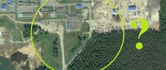
How to determine on the ground?
There are two ways to determine the boundaries of plots: geodetic, which involves land surveying, and declarative (without inspection and land surveying).
Geodetic principle
Involves inspection, measurement, photography and drawing up a site plan. If there is already a cadastral passport, but as a result of the measurement the boundaries have been changed, then the plan is approved by the Land Relations Committee and re-registered with the cadastral register.
Declarative principle
It assumes that the cadastral passport will not contain a plan-scheme, which is drawn up by an engineer on the ground. The exact turning points, which are very important in case of disputes with neighbors, will not be indicated. If the passport has already been issued using the declarative method, then it can be adjusted. To do this, you need to contact land surveying specialists and ask them to reassign the coordinates of turning points on the site.
Land surveying in a gardening partnership
The general plan of SNT often does not contain the exact coordinates of the boundaries of the plots, so land surveying is still necessary. Dachas and garden plots are usually closely adjacent to each other, therefore, to determine the boundaries, an Act on the coordination of boundaries with neighbors is often required. If they refused to sign the deed, then you have the right to file a lawsuit to establish the boundaries of the land plot.
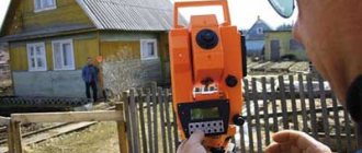
Provision of geodetic services and prices
Land surveying is carried out by cadastral engineers who work in private geodetic companies that have a license for this type of activity. The register of cadastral engineers who have passed certification is available on the Rosreestr website. The check can be carried out both by the name of the specialist and by the number of his certificate.
The price ranges from 20 to 50 thousand rubles.
Call a surveyor
If you decide to invite a cadastral engineer or surveyor, then check his experience, registration and certificate. Before starting work, he will need to present a passport and documents confirming the legal ownership of the site. Sometimes surveyors are asked to confirm the absence of electrical cables on the ground or public communications that they could damage during the work.
Turning points of allotment boundaries: what are they and why are they needed
So, each land plot must be registered with state control authorities, and also receive a cadastral number and be entered in a special book. By the way, the coordinates of the turning points of the boundaries of the land plot make it possible to quickly delineate and indicate the territory on which the developer will operate in the future.
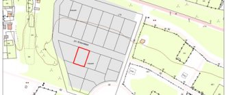
The cadastral extract always contains a site plan, presented in the form of a geometric figure. Basically, the sections have a square or rectangular shape, starting from the turning points. But there are also options when a site has only a couple of clear coordinates, the rest are described by curves. This image method is determined by the characteristics of the landscape, for example, on slopes or in mountainous areas.
However, each change in the trajectory must be recorded by its own point, otherwise large errors are possible, for example, encroachments on a neighboring area, which will lead to legal proceedings.
If you imagine a cadastral plan in front of you, then the site will consist of a large number of points connected to each other and forming a boundary. Each such point will be called a turning point and will have its own coordinate (XY). In practice, such places are always marked with signs that allow you to see the size of the area in real life. They also help the cadastral engineer enter data on the location and shape of the plot into the State Property Committee. There he is assigned his own number, thereby distinguishing the site from its surroundings and designating this territory as the property of another person.
Important: after surveying, moving signs is strictly prohibited. The data entered into the cadastral book is checked by supervisory authorities, therefore, unauthorized expansion or relocation of the site will be punishable by law.
Step by step process
The boundaries of the site can be established:
- independently on the ground;
- in the cadastre.
In the first case, fences are installed independently, the mesh is stretched and the boundaries of the site are formed.
This is the most popular method of determination, however, it does not have legal force. In the second case, the boundaries are clarified by a cadastral engineer or surveyor, who draws up a site plan in the form of a drawing describing the location, area and other important parameters.
How can I find out from my site?
In order to find out this information, you can contact your local land resources department or enter the address and cadastral number in the search system on the Rosreestr website. If you cannot find the data, it means that the land is not taken into account, and it is necessary to conduct a land survey and include it in the cadastre.
Search with surveying
If the boundaries of the site have already been determined, then there must be a cadastral passport on which the individual number is indicated. This is what you should use to search for information on the Internet. The cadastral plan of the site can be found on the Public Cadastral Map, but keep in mind that the site may take a long time to load and work intermittently.
Information about the area of the plot, the date of its registration, cadastral value, category of land, type of permitted use (for example, for agriculture or development) is also easily available there. A cadastral passport or a paper extract can be ordered from the MFC, Rosreestr.
Important: Land surveying involves not only taking measurements, but also preparing land survey work. The cadastral passport must be issued in accordance with all the norms of the State Cadastre. Only if there are no complaints about the matter is the plot assigned its own cadastral number.
Search without surveying
If the site has not undergone land surveying, then no plan has been drawn up and there will be no information about it on the Public Cadastral Map. When you contact the MFC or Rosreestr for an extract from the register, you will also be refused, since they will not be able to find information about the site.
To carry out any operations with land in the future, it is necessary to register it. Otherwise, there is a risk that someone will seize the plot without permission and it will be difficult to challenge this.
What to do if the boundaries are not defined?
If you find that the land is not listed anywhere, then you need to carry out a land survey.
Only the owner of the land plot has the right to initiate such a procedure. If the boundaries of the plot are not defined, then it is also necessary to request information about where exactly the boundaries of all adjacent land plots are located in order to avoid intersections and squatting.
For land surveying you need:
- Call a cadastral engineer to determine the boundaries of the site.
- Write an application for ordering geodetic services and conclude an agreement.
- Notify neighbors (if there are adjacent areas) that land surveying will be carried out (at least a week before the start of the procedure).
- Carry out land surveying.
- Wait for the written registration of the act, and then the land survey plan and other documents for the Cadastral Chamber.
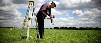
To obtain a cadastral passport, you need to do a cadastral survey, mapping out the boundaries and all the necessary measurements. A technical specification is also drawn up, in which the points for placing boundary signs are determined, and the boundaries are also secured.
This is a very complex procedure that cannot be carried out independently, without the involvement of a surveyor with professional equipment.
Procedure
The location of the boundaries is established by determining the coordinates of characteristic points and dividing them into parts. Clarification of boundaries is also possible by indicating natural and other objects, if information about them is contained in the cadastre. The area of the plot will be the area of the geometric figure formed by the projection of the boundaries of the land plot onto a horizontal plane.
For surveying the following is carried out:
- study of documents on the land plot;
- preparation of a land surveying project;
- notifying neighbors about the date of boundary determination;
- measuring a site on the ground, geodetic survey, determining boundary signs, determining the size of the area;
- preparation of a boundary plan and file for submitting documents for registration.
Upon completion of the work, the landowner receives two copies of the boundary plan. He takes one of them to the cadastral chamber. Next, having received the cadastral number of the plot, you can contact Rosreestr to obtain a certificate of registration of ownership.
By coordinates
If the plot is located in an area remote from other plots and is not in the cadastre, then its boundaries can be determined by the coordinates in the navigator. This method is often used by surveyors who use a geocalculator and other programs for searching a site by coordinates and determining its area (the “Surveyor” application, GPS-status, Location Detector, etc.).
According to actual use
This is the most popular land surveying method in the Russian Federation. For example, you have a plot and you use it and a small area next to the road or neighbors’ plot. If there are no title documents for the site, the boundaries can be established along an artificial fence that has existed for more than 15 years.
To determine boundaries, horizontal surveying and coordination of boundary signs with neighbors (if any) are used. If it turns out that the landowner uses a larger area of the allotment than he is entitled to according to the documents, then this excess should not be more than 10%.
How are the dimensions of an administrative area determined?
If land is provided for construction by the city administration, then usually there is no need to delineate the boundaries of the plots (the plots are provided already registered in the cadastral register). To obtain land, you need to submit an application and, of course, meet the requirements that the state puts forward for applicants for free plots. Usually, the so-called “site bank,” that is, ownerless plots of land are offered to large families for development. The boundaries and sizes of the plots, in this case, are determined by the administration itself.
How to check boundaries?
The boundaries of land plots are usually considered to be the lines of contact of the plot with other territories. The easiest way to determine boundaries is using the Public Cadastral Map (PCC) .
Its creation and updating is carried out by Rosreestr specialists, which guarantees that you receive up-to-date information. If necessary, you can save the found data in Excel. Users can see what the area they are interested in looks like, with the boundaries highlighted on one of the proposed maps:
- Google Maps.
Allows you not only to study a satellite map, plan or diagram on which the boundaries of the land plot are marked, but also to see a panoramic view of the area (read about what a cadastral plan of a land plot looks like here, about what a cadastral plan of a land plot is, where and how get it, find out here). The main advantage of Google Maps is the ability to take a virtual trip through the territory of any region. - Initially, this service stored information about city organizations and the buildings in which they are located. Later, 2GIS connected to the Rosreestr program and began to provide a schematic map of territories. This resource is created by users who upload photographs of sites into it. You won't be able to find cadastral markers here, but you can see photographs of the plots. This is especially useful for those who are thinking about buying land plots (read about who can buy land at cadastral value from the administration and the state and how to do it here).
- Yandex maps. They differ from PKK in a more comfortable scaling tool and the presence of not only diagrams of territories, including borders, but also their satellite images.
All of the services listed above allow you to find out the boundaries of the memory. The difference between them is only in the display of information, so everyone can independently choose which card to use.
To determine the boundaries of the allotment according to the PKK, you need to perform the following steps:
- Follow the link https://egrp365.ru/map/. The most current data is displayed here.
- In the upper right corner of the page there is a window where the user can select the desired card.
- In the menu, you can check the box next to the item “Show cadastral boundaries of plots”. In this case, a grid of territories will be immediately superimposed on the PKK.
- Oh, the user can select the criteria for displaying information:
- by cadastral value (find out about determining the cadastral value of a land plot in this material);
- by form of ownership;
- by category;
- on territorial zoning, etc.
- After setting the parameters, you need to enter the cadastral number in the empty line and click the “Search” button.
- The requested area will appear on the map. If you click on it with the left mouse button, you can find out such data as the area of the plot, its form of ownership, etc.
Required documents
When surveying, you will need to draw up a text to notify neighbors about the date of measurement and approval of boundaries.
A meeting of neighbors is held, at which an act of approval of the boundaries of the land plot is drawn up. For the surveying procedure itself, you need:
- passport, title documents for the site;
- a copy of the general plan of the settlement (preferably);
- the previous cadastral passport of the site and a plan of the territory (if any).
The boundaries are considered agreed upon only when the deed contains the signatures of all neighbors, as well as the signature of the cadastral engineer and the seal of the head of the village administration. After surveying, a boundary plan is drawn up indicating the area, location and boundaries of the site.
Permissible errors
According to the law, permissible errors allow turning points obtained as a result of measurements to be determined as actual boundaries. But only on condition that the indicators do not exceed the established values:
1. For agricultural land – 2.5 m.
2. For lands on which dachas are located – 0.2 m.
3. For lands located within the city – 0.1 m.
Accordingly, if the coordinate indicators go beyond the limits, but are within the above values, then a boundary plan based on turning points is still formed.
If inconsistencies are found
If you find discrepancies between the boundaries of the site and those stated in the passport, or if disputes arise with neighbors, you can order a geodetic service to map out the boundaries. In this case, the geodetic company will thoroughly study all available documents for the site, make an inquiry about adjacent plots and conduct field work to determine the characteristic points of the land plot and secure them with signs.
After this, so-called desk processing of the data will follow and an act of drawing out the boundaries of the land plot will be drawn up. The new boundaries will be fixed by boundary signs and may be legalized. If the plot was measured and the seizure of land by neighbors was discovered, then this issue will need to be resolved in court.
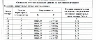
Border coordinates
According to the legislation of the Russian Federation, information about any allocated plot must be entered into a unified state register. There are several document forms that reflect such information, but all of them contain data on border coordinates.
Note ! Such plans reflect information about a specific land plot, which makes it possible to distinguish it from any other plot.
Single points allow you to determine the location of the boundaries of the land plot. Their coordinates indicate where the boundary will be.
Coordinates of turning points
The coordinates of turning points, recorded by boundary signs on the ground, are determined separately in a special table in the boundary plan. This data is not included in the cadastral passport.
If you need coordinates of turning points , then you will have to make an extract from the information of the Unified Land Management using the KV 6 form, in which the coordinates of the turning points will be indicated on the first page.
Each point is determined in the system of intersection of X and Y coordinates, as a result of which its most accurate location in space is determined. This form provides information about the location of the coordinates of each turning point in relation to all turning points of the site available in the land surveying file.
Keep in mind that the presence of coordinates of turning points will not give you the opportunity to verify the passage of the boundary line along them yourself. This is a rather complex procedure that can only be performed by a competent specialist with the status of a cadastral engineer.
How to determine the boundaries of a land plot by coordinates
So, the coordinates of the turning points of the allotment boundaries are a calculation of the territory defined by cadastral registration as a plot of land belonging to a certain person. In this case, the plan has its own shape, which consists of straight and curved lines. Each bend has several coordinate points at once, and the straight line consists of the start and end points (XY) as a vector.
In practice, the territory is marked with special signs. And the coordinates of the borders are entered into an electronic database for further work with them. Thus, no neighbor will be able to move the fence to another’s property, because such actions violate the letter of the law.
The boundary determination process is as follows: the applicant brings the necessary documents to remove the boundaries, after which the engineer goes to the area. There he carefully measures and lays out the boundaries. Then he installs signs with instructions in special places (at the turns of the edges). The next step is for surveyors to arrive on site and adjust the dimensions if the situation requires it.
Even taking into account the fact that they are working according to the preliminary plan of the cadastral engineer, they have the right to move turning points and mark the site until everything is aligned to legal standards. Also in their work they install pegs at “turning points”. At the same time, technical specifications are drawn up for cadastral surveying and entered into the EDB.
The next step is for the cadastral engineer to visit the area again and check the specified coordinates with the results of the surveyors. A special report and preliminary survey report are drawn up, and information about the placement of signs is sent to the regulatory body. Now the worker begins to determine the boundaries and distinguish the site from other neighboring ones.
Cadastral work on the ground is carried out in parallel with the preparation of papers and the drawing up of a land plot plan. We will carry out a clear sequence of actions of all regulatory and supervisory structures: preliminary marking by an engineer; placing pegs according to coordinates, drawing straight lines between turning points; data reconciliation; cadastral survey; entry into the electronic database of Rosreestr.
This series of actions is expressed in the complexity of working on the ground and checking with topographic photos. Land surveying is also differentiated depending on the purpose of the survey, for example, signs with signs are installed only at the very end, when all coordinates have been checked by a cadastral engineer and correspond to their location indicated in the cadastral book.
The legal capacity of the land allotment depends on the quality of the work performed, and therefore neglecting this work is strictly prohibited.