What is a situation plan
The land situation plan is a schematic representation of the site and the surrounding area. The defining features of the territory planning project are set out in Art. 42 of the Town Planning Code of the Russian Federation. The plan includes not only the boundaries of the plot, but also images of objects and buildings located on the territory and in close proximity to it.
The structure of the document’s presentation is indicated in Part 4 of Art. 42 Civil Code of the Russian Federation. The work is carried out with geodetic and topographic measurements. Information is displayed at a scale of 1:500, 1:1000, 1:2000. The use of other formats is not permitted.
The situational plan of a land plot differs in its content from other schemes. It does not show the terrain and does not contain inscriptions. The image has symbols, which are explained in the comments.
Visualization of a land plot in the form of a situational plan is most often created for specialized services for the supply of utility networks. Signs and symbols are simple and understandable to both specialists and laymen.
Why do you need a plan?
As a general principle, a situational plan of the site is required to make any structural changes when modernizing the territory of the property. Of particular importance is the nature of the work carried out and its impact on adjacent lands.
The most common situations when you need to prepare a document are:
- Conducting transactions to re-register land ownership. When drawing up a purchase and sale agreement, a gift, or during inheritance, it is necessary to draw up a boundary plan. Drawing up a survey act requires indicating the boundaries of the site from the calculations of the situational plan.
- Construction of capital and technical buildings on the site. When planning the construction of a residential building or non-residential extension, you should prepare a situational plan of the site based on the terrain and utilities.
- Supply of electrical networks, gas and water supply. The drawing up of the diagram must be approached in detail. For gas supply, the location of the source for connection is indicated, as well as the object requiring connection to the supply source. Electrification can be coordinated if the wiring in a residential building is outlined in the plan, indicating the characteristics of the equipment, and the cable layout on the site. It is important to note the external sources of electricity to which you plan to connect. The situational plan must indicate the deadlines for the delivery of objects.
What information does it contain?
The land plot plan has the following content:
- image of the site in accordance with the address;
- orientation to the cardinal directions;
- indication of trees, bushes, buildings, and other landscape objects;
- infrastructure connections to the road network;
- communications on or near the site;
- an indication of specially protected natural areas located next to the land plot;
- informing about negative buildings, structures, objects located in close proximity.
The situation plan is drawn up by order of the owner of the territory and certified by the signature of the contractor. The document has the following structure:
- directly graphical diagram;
- text description;
- plans for the reconstruction of the territory.
The diagram shows the proposed locations for laying electrical cables, construction and modernization of facilities.
Topographic plan
A topographical plan is considered to be a drawing of a small area made on a large scale. The drawing does not take into account curvature, but maintains a given scale in any direction and at any point.
Topographical surveying of the area may be needed in several cases:
- In order to obtain permission to carry out the construction of any structure;
- When redesigning communication networks;
- When designing;
- When preparing documents establishing boundaries and defining areas.
There are several types of topographic survey:
- Special or general purpose;
- Displaying dendroplane – woody;
- Displaying engineering communications;
- Landscape;
- Large scale, etc.
The most popular type is large-scale photography; it is done for:
- Conducting surveys;
- Formation of general plans for certain territories;
- Clarification of topographic data;
- For a landscaping project;
- Development of projects and drawings.
The main result of a topographic survey is a drawing that displays precise indicators of the relief, vegetation and buildings in a given area.
Carrying out topographic work is divided into 3 stages:
- Preparatory work . It involves the collection of certain documentation and its analysis:
- The customer develops and submits technical specifications to the contractor;
- The geodetic survey of the site carried out earlier is analyzed;
- Permission is requested and obtained to conduct topographic survey work.
- Field stage of work . Specialists visually inspect the site, examine it and select a place to install geodetic points and survey the area.
- Cameral stage . Summarizing the received data and documentation and, based on them, developing a topographic plan.
How to get a?
To obtain a topographic plan of the area when planning construction work, you must contact a geodetic company accredited to carry out such work. The customer provides the contractor with a specific technical task, after which the parties agree on an estimate of the work and enter into a contract.
The preparatory stage involves the participation of the customer himself:
- He must provide the contractor with all the maps he has - cadastral and situational plans, diagrams of engineering structures;
- Obtain approval from the architectural department to conclude an agreement with the contractor and, for this purpose, submit documents on your rights to this territory;
After field work, the contractor must agree with the customer on a topographic plan, which will serve as a preparatory plan. After this, the contractor coordinates the plan with the organizations operating engineering communications.
At the final stage, surveyors submit a report in four copies to the architectural department.
Types of situational plans
Situational plans are drawn up based on the following criteria:
- scale of work;
- goals for creating the project.
When preparing land plot plans, the following scales are used:
- 1:500 – for the construction of buildings and structures, compiled on the basis of fresh topographic images.
- 1:1000 – establishes the location of buildings and the location of pipelines.
- 1:2000 – when laying supply networks, for connecting to supply resources.
According to the target criterion, the following are distinguished:
- a general informative situational plan of the land plot, indicating the approximate area and location of buildings, is drawn up to assess the possibilities for further exploitation of the plot (recommended scales - 1:500; 1:2000);
- situational plan of the site for a water utility or subsequent gasification on a scale of 1:2000 with determination of the location of buildings and the depth of the pipeline;
- The electrification diagram allows you to determine the location of real estate and transformers on the site.
By agreement with the engineers of the resource supply companies, the document can be drawn up using other scales that make it possible to reflect in detail the features of a particular land plot.
What is a cadastral plan of a land plot?
Cadastral plan - a diagram of the boundaries of the territory. Information is necessary to determine the inventory and cadastral value of the plot. The document consists of text and graphic parts. In each, the area of the building and the distances relative to neighboring objects are recorded. The document is divided into 5 types:
- Mezhevoy . Contains text and a graphic with the boundaries and dimensions of the object. This information is needed to assign a registration number. Compiled when dividing and merging plots to accurately determine boundaries.
- Technical . It also includes a diagram and a text part about the buildings on the site (residential and commercial, finished and unfinished).
- Duty cadastral map . Shows in which zone the property is located.
- Derived map . Describes the territory: nearby social facilities, economic purposes, natural resources, etc.
- Public . This is publicly available information about the site on the Rosreestr website. To receive it, the address of the allotment is entered in the column.
IMPORTANT! The cadastral plan legally proves the existence of an object on the territory of the country and its ownership by a specific owner.
Where to get it
Art. 8 of the Civil Code of the Russian Federation gives local government authorities the authority to prepare and approve settlement plans, the right to issue permits for the development of territories and approve land use rules. The owner of the site can order a situation plan:
- in the municipality;
- in a private company specializing in the preparation of graphic and descriptive documentation of real estate.
The provision of services by the administration of the locality is carried out on an application basis free of charge. A commercial organization sets its tariffs in accordance with the volume of work performed.
When contacting a municipal authority you will need:
- completed application;
- passport of the owner of the territory;
- documentary evidence of ownership of the land plot.
The following grounds for refusal to provide services are assumed:
- an incorrectly drawn up application;
- the person applying for the provision of municipal services is not the owner of the land;
- the applicant has not provided all the necessary documents.
In other cases, you can appeal the municipality’s refusal in court.
You can order the production of a situation plan using the cadastral number of the site. Most of the real estate objects are assigned a specific number, which allows you to identify a specific land and find out its main characteristics.
Regardless of the method of obtaining the plot - inheritance, donation, purchase and sale - the cadastral number is retained. In this case, the citizen can apply:
- upon application to Rosreestr;
- upon personal visit to the MFC.
The list of documents provided is similar to what is submitted to the administration of the locality. It is important to pay attention that if there are residential properties or outbuildings on the site, title documents for them are also submitted.
A situation plan is prepared within 10 days after contacting Rosreestr or the MFC. The service is provided free of charge to both citizens - land owners and representatives of a legal entity acting under a notarized power of attorney. The refusal must be made in writing.
For gasification
You can obtain information about where to draw up a situation plan for a specific site from the gas supply organization at the location of the land. At the first stage, you will need coordinate data for the territory. If there is no such information about the site:
- the owner of the land can contact an architectural company that has a license to draw up site plans; a specialist will take measurements of the territory and draw up a plan on a scale of 1:2000;
- make a diagram of the land plot and a description for it yourself, using satellite images.
If the owner of the land intends to gasify the facility, a situation plan will be required for connection to the gas pipeline by engineers of a specialized office. The document is submitted in A4 format with an image of the site in the context of reference to the area in which it is located. The professional activities of a cadastral engineer are regulated by the provisions of Federal Laws No. 221-FZ and No. 128-FZ.
For electrical networks
The owner can obtain a situational plan of the land from the municipality. In special cases, it is necessary to obtain approval for the installation of electrical networks. The territorial committee of architecture may be involved in resolving the issue.
Electrical networks require a situational plan on a scale of 1:2000 or 1:500. It will have to be compiled after photographing the area. It is necessary to draw diagrams of energy-receiving capacities. The document must display the following information:
- land boundaries;
- erected buildings;
- power lines;
- places of connection to the electrical network;
- voltage power;
- types of electrical equipment;
- designation of the cable for supplying current, its characteristics.
The work must be certified by the contractor, who took measurements and displayed the objects graphically. You will also have to seek assurance from the head of the territorial cadastral service.
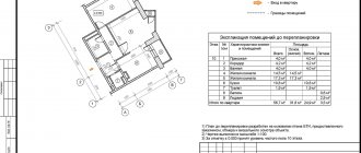
Contents and sections of the plan
The land plot plan is placed on several sheets and consists of six sections. The first section contains the details of the customer and contractor, the date the document was drawn up, source documentation and measurement methods used by the engineer during preparation. As well as the following characteristics of the object:
- location;
- square;
- land category;
- type of use.
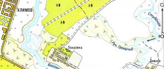
The second section is a diagram drawn up after the survey, with external outlines and turning points. The graphic image shows the territory, a specific object in the total mass is highlighted with red lines.
The third section is included if there are encumbrances or restrictions on property rights on the land. For example, the property is located in a protected area.
The fourth point is a drawing that shows the relationship of the land with nearby objects.
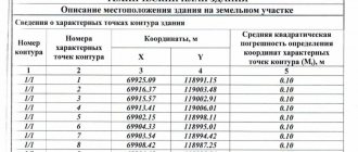
The fifth section includes a table describing the coordinates of neighboring lands and their cadastral numbers.
The sixth part includes a table with nodal and turning points of allotment lines.
How to download for free
It is impossible to find a ready-made plot plan on the Internet. Each plot has its own characteristics. Help in drawing up the document will be:
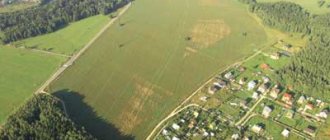
- Photographs of the area, presented in the public domain on Google and Yandex maps (https://www.google.ru/maps; https://yandex.ru/maps/), display the object at the specified address.
- Data from the public cadastral map of Rosreestr.
- Software used by surveyors and cadastral engineers.
Negative aspects when drawing up a situational plan on your own may include:
- inconsistency of the selected photo scale;
- poor quality of printed photographs from the Internet;
- lack of experience in drawing up plans and diagrams;
- specialized geodetic programs are complex and incomprehensible to the average citizen.
You can display the situational plan by hand by taking measurements of the land plot. In this case, it is advisable to consult with a cadastral engineer about the specifics of taking measurements.
A person without experience working with maps and diagrams will most likely not be able to outline the characteristic features of a land plot on paper, because it is necessary not only to orientate oneself to the cardinal points, but also to display objects on the plot on the required scale.
Graphic clarity is extremely important and is taken into account when transmitting the plan to government agencies. If the plan is drawn up with violations, it will be impossible to supply gas and electricity.
How to make a plan yourself
If a citizen does not want to seek the help of commercial organizations or local administration, collect documents and visit departments, he can draw up a situational site plan on his own. To do this you will have to spend some free time.
When working with a situational plan, you must be guided by the orders of the Ministry of Regional Development of the Russian Federation “On approval of the form of an urban planning plan for a land plot” and “On approval of the instructions on the procedure for filling out the form of an urban planning plan of a land plot.”
You can prepare the document yourself in the SAS.Planet program, you can download it on the website https://sasgis.ru/. It is also suggested to refer to the site Gis-lab.info. Recommendations offered by Internet resources will help you understand the features of drawing up situational plans for land plots.
Why is a cadastral plan necessary?
The scheme is needed for registration and when making real estate transactions. Information about territorial boundaries is stored in the Rosreestr database. If necessary, a citizen has the right to request a cadastral plan of real estate by paying a state fee.
ATTENTION! If the boundaries of the site are shifted (when merging or dividing territories), a new document must be drawn up.
To draw up a plan, you need to survey the land. The procedure is necessary to determine the boundaries of plots and avoid disputes with neighbors regarding boundaries.
Arbitrage practice
Disputes and conflicts between land neighbors are resolved through litigation. To establish the truth and restore violated civil rights, a situation plan is requested.
Knyashkin G.A. filed a lawsuit against his neighbors Savelyev. The defendants built a house on their site and, violating the development plan, built a sloping roof over a residential building. The accumulation of snow precipitation caused a one-time collapse, as a result of which the polycarbonate canopy of G.A. Kshnyakin collapsed.
One of the buildings on the Savelyevs’ property is used as a bathhouse; its location near the plaintiff’s house creates a fire hazard. The defendants also built outbuildings, entering the territory of G.A. Knyashkin.
The Buzuluksky District Court of the Orenburg Region ordered the Savelyevs to regularly clean the snow on the roof in winter, and also to compensate their neighbor for the cost of the canopy. The appellate court partially overturned the district court's decision and ordered the Savelyevs to demolish temporary buildings and a bathhouse.