What is geodetic surveying of facades? What types of geodetic surveys are there? Why do you need a geodetic map of a land plot?
Good afternoon, dear readers of the HeatherBober online publishing house. Today we will get acquainted with geodetic surveying of the area. I, the expert and author of the article, Viktor Golikov, will help with topographic maps.
First, try to draw a diagram of your apartment. And then, according to the diagram, with the help of poles, try to transfer this plan to the ground. Of course, proportionally. You will be surprised how little space your square meters take up on the ground!
Now think about how the house where you live was built? The same land is in front of you. Why not repeat this architectural masterpiece yourself, and even improve the project?
What's so difficult about this? Paper, ruler, pencil. But let's read the article first!
What is geodetic survey
In some ways, this type of geodetic work is reminiscent of cinema. Shoot on film, shoot on a card - do you find any analogies? Don't look, they don't exist!
Geodetic surveying involves a set of measurements on the ground and transferring them at the appropriate scale to the map.
And all the work begins with linking the map to the surrounding territory. We orient our future diagram according to the cardinal directions and mark control points relative to geodetic signs.
Ask where to look for them? Geodetic signs are everywhere, you just haven’t noticed them before. Concrete pillars or foundations, incomprehensible metal structures containing markings: latitude, longitude, height - these are the reference points for any geodetic survey.
And for further shooting we will need to measure angles and distances on the ground in order to mark the boundaries of the site. This is where the drawing of a geodetic map begins, and this is the goal of our work.
Using a geodetic map, further design takes place:
- buildings are located;
- communications are determined;
- materials are selected;
- the depth of the foundation is determined;
- a cost estimate is drawn up.
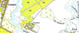
Note that a geodetic map differs from a topographic map in that it is horizontal and the terrain is not marked on it. Therefore, such cards are made much faster and cost less.
Geodetic maps are used to draw the contours of a site and buildings, thereby determining the boundaries and area of a land plot.
See the article “Geodetic works”.
What is the difference between a topographic map and a site plan?
Site plans, as well as topographic maps, are variants of geographic maps . However, such terrain drawings are not identical.
The first is a detailed image of an area in which everything, even extremely small objects, is reflected, that is, it is characterized by detail and completeness. Typically the plan scale does not exceed 1:10000.
Objects existing on the ground are transferred to the plan almost in kind; their size is easily calculated using a numerical scale line. In this case, the image does not take into account the curvature of the earth's surface.
Distortion when imaging small areas is insignificant, so the indicator can be neglected.
Topographic maps are also a scaled-down representation of the area, but have their own characteristics :
- A large scale is used, which does not allow depicting small objects in detail;
- Degree grid lines are displayed, taking into account, among other things, the curvature of the earth's surface;
- A special system of symbols is established, which differs from that used when drawing the area plan. First of all, this concerns color schemes: on a map, colors are used to display altitude, and on a plan, to indicate individual relief objects, such as mountains or forests.
A map is used for a general overview of the territory and the objects on it, while a plan allows you to study a small area of the earth's surface in more detail .
When geodetic surveying is necessary - an overview of the main situations
Why is a geodetic plan of a land plot needed? To refer to it in case of difficulties in determining the boundaries and location, coordinates of your property.
Let's imagine that we urgently need a plan for a plot of land. In what are the most common cases do surveyors turn to surveyors for help and is it possible to do it on our own?
Situation 1. Registration of a property for cadastral registration
Geodesy of a site is most often ordered by cadastral workers for registration. They need the exact coordinates of your site. It is almost impossible to make such measurements yourself.
To accurately measure the boundaries of a land plot you will need:
- special skills in working with surveying instruments (as well as the instruments themselves);
- certificates of conformity (your qualifications as a specialist);
- special knowledge on constructing and linking a site to a geodetic network and more.
This is why the demarcation of the territory is carried out by professionals, so that in the cadastral register one plot borders on another, and does not have cross lands. If the geodetic survey was done incorrectly and the coordinates were transferred to the cadastral engineer, there will be legal consequences.
Situation 2. Disputes with neighbors
Often, on dacha plots, neighbors dispute the territorial boundaries of their land plots. A geodetic plan provides for reference to specific coordinates, thanks to which it is possible to absolutely accurately draw the contour of a land plot on the ground. Or even better, remove the boundaries of the land plot in situ.
Let's watch a video on how to resolve neighbor disputes.
In addition, we should not forget about building codes. The construction of structures on a land plot must correspond to certain values and distances from public lands and neighboring territories.
Situation 3. Division or merger of plots
In this case, surveying is necessary for the legal redevelopment of the plots. Moreover, it is better to do this before starting work. Formally, nothing will change, but from the point of view of the law, the boundaries of your plot have been changed, and the cadastral entries in the register must be changed accordingly.
Changing the boundaries of plots is a change in the volume of property, which means it must be regulated by law. Otherwise, the boundaries can be challenged in court by any interested party.
Situation 4. Conducting property transactions with land
In this case, geodetic survey is part of the process of buying and selling real estate. The land must be assessed, and for this a site plan is needed.
In addition, you can sell part of the plot, rent it out, or provide a site for the construction of any structure - all this requires surveying, including engineering surveys for construction.
Situation 5. Determining the area of the site
The most banal and most frequently performed work. In 99% of cases, surveying is ordered to accurately determine the size of the plot and, accordingly, the amount of taxes.
Also, surveys of the area of land are carried out on abandoned lands and on newly developed ones. This work is most often carried out in combination with topographic surveying of the area.
How to make a topographic survey yourself
An accurate assessment of the area can only be made by a certified specialist who has a set of expensive measuring equipment.
Only a plan drawn up, certified in accordance with the requirements of the law, will be considered an official document confirming the conduct of land management work.
However, for your own needs, you can use a land plot plan drawn up with your own hands. It allows you to make the calculations necessary for minor changes in the appearance of the site, for example, laying paths or creating artificial reservoirs.
Required Tools
The set of tools required for taking measurements is quite simple. To carry out your own topographic survey you will need:
- Heavy hammer.
- 1.5 meter wooden stakes.
- Construction level or laser pointer.
- A tape measure designed for at least 30 meters.
- Long ropes.
It should be remembered that the results obtained using such tools are approximate and it is impossible to build capital structures based on them.
Order of conduct
Prepared wooden poles are installed at base points, which are the corners of the site. A rope is stretched between them, which should not sag.
The attachment point is located at a height of a meter from the earth's surface. You can determine the exact position using a building level. Next, use a tape measure to measure the distance from the ground to the stretched rope and record the results on the terrain drawing.
The next step is to compare the results obtained with a specific site plan, which can be downloaded from the Rosreestr website
It is important to take into account the scale of your own drawing and the official map
Objects that are planned to be built must be located taking into account the red lines.
What are the types of geodetic surveys - 5 main types
Topographical surveys of sites are carried out in cases of restructuring or reconstruction of structures to draw the general plan of the site and when transferring the construction project into operation.
Depending on the application, they are divided into several types.
Type 1. Topographic survey
Topographic survey includes measuring the elevation of some points over others, the distance between them, as well as angular measurements. The dimensions of all buildings and underground communications are noted. Water and plant objects, the presence of roads and access roads are highlighted.
Topographic survey is used to build an electronic model of the area, as well as for planning vertical structures and landscape design.
Type 2. Executive photography
Such work is carried out at the final stage of construction and represents a set of surveys aimed at comparing the actually completed structures with the initial design data. As-built surveying is also used at various stages of construction in order to monitor deviations from building codes.
Read a more detailed article on our website: “Executive filming.”
View 3. Facade photography
This is specialized executive photography. It is distinguished as a separate type because the work is carried out exclusively on the external surface of buildings.
As a result of the work, the plan displays:
- building coordinates;
- height of the structure;
- dimensions and height of parts of the facade.
Facade photography is used during the construction and reconstruction of buildings, when measuring the dimensions and area of structures, and when calculating construction estimates for the restoration of historical buildings. Such work is often associated with conducting a construction examination of buildings and structures.
View 4. Vertical shooting
This type of geodetic work is designed to study the terrain. The excess of some points over others and the determination of equal heights on a site is also called leveling.
As a result of the research, the following measurements are made:
- slope of the land;
- maximum and minimum height values;
- isolines with the same altitude indicators.
In practice, vertical surveying is used to determine the location where a future building will be most stable in a particular landscape. And also to determine the slope of the route profile - for example, when laying pipelines or similar trench structures.
Vertical surveys of land plots are usually carried out in conjunction with geological surveys.
View 5. Horizontal shooting
Similar type of work to the previous ones. The only difference is that during horizontal surveys the altitude range of the territory is not indicated. It is not possible to trace the relief here, but it is convenient to draw the outline of buildings.
Example
"Veselye Drawers" LLP will produce a geodetic map according to your drawing, without visiting the site and other unnecessary problems!
Horizontal or contour surveys are used to create plans for irregularly shaped areas or elongated, longitudinal areas. Most often, this type of topographic survey is used when studying streets and distances between buildings.
How geodetic surveying is carried out - 7 main stages
Do you need geodetic work on a piece of land? Do you want to take part in the work or just place an order with a specialized company? Most likely, you won't have to choose here.
Only a duo of a specialized specialist and a client of a geodetic company can draw up a qualified report that meets state standards. You will need special skills and abilities, and the surveyor will need your property documents and interest in solving their problems. So where to start?
Stage 1. Study of materials on an already ongoing survey of the area
Let's collect the documents we already have. If you have the rights to carry out any work on the territory, you must have a plan or diagram of this plot of land. Surely topographic work has already been carried out here, which means there are maps in the local department of architecture and urban planning.
If you haven’t found anything, and a preliminary analysis requires at least some starting point, you can always look at the territory on Internet maps of well-known search engines.
Even if this option did not help you, then you will find the most detailed maps of the former USSR by searching for “topographic maps of the General Staff”.
Stage 2. Drawing up and registering a work plan
To systematize the process of conducting geodetic surveys, it is necessary to draw up a work plan. To do this, you will need to agree on the timing and scope of work with the geodetic company. And this, in turn, will require drawing up technical specifications for specialists.
Grandfather with a pen, grandmother with a piece of paper, task.
A grandfather with a pen, a grandmother with a leaf, a granddaughter with a ruler, a bug with a tape measure, a cat and a mouse got together and... came up with a geodetic technical task!
Together with surveyors, based on the terms of reference, draw up an action plan. Our experts will help you choose the optimal solution to achieve your shooting goals. For your part, try to provide all the necessary documents and access to the site.
Stage 3. Obtaining permission to film
At this stage, the usual bureaucratic confusion often arises. The geodetic organization that will conduct the survey must have a license for its activities. If there is one, you simply register your work with the geological and geodetic supervision service.
Permission as such is not required. But enterprises that are not accredited in the SRO system (self-regulatory organizations) do not have the right to conduct surveys. It will not be possible to register such works and the shooting will have nominal significance.
Moreover, the registration rule does not apply throughout the entire territory of the Russian Federation. The thing is that there are areas in which the above-mentioned committee does not exist and there is simply nowhere to register your research.
Stage 4. Site investigation and installation of geodetic networks
An initial visit to the site is made by a specialist to assess the general geographical location of the territory, access routes and surrounding areas. Naturally, we can’t do this without you; we’ll have to accompany you and give comments. Most likely, additional information will be needed about the characteristics of the soil, hidden routes and structures on the site.
The specialist will draw up a final estimate and invite you to sign the contract, if one has not been concluded previously.
Let's look at the table of geodetic survey prices:
| № | Name | Volume of work | price, rub. |
| 1 | Geodetic reference network | 10 acres | 9 000 |
| 2 | Axle breakdown | 2 points | 3 000 |
| 3 | Facade photography | 1 sq.m. | 50 |
| 4 | Full support | An object | 100 000 |
The next step is to install a geodetic network. Your site will be tied to points that already have exact coordinates, thereby securing the boundaries of the site and setting the location of the territory on a geodetic map.
Stage 5. Surveying all facades and structures
Further actions do not depend on you. Your mission as a client is completed. Surveyors get down to business.
Work begins from the established geodetic base. These are reference points from which all measurements will be taken.
Give me a foothold and I'll send a surveyor there!
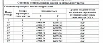
The results of the work are recorded in a special journal. Essentially, this is a table indicating the exact coordinates of various points on a plot of land. Thanks to this data, a schematic map of your site will be created.
Stage 6. Processing the received data and checking its accuracy
This field work is not completed. Self-respecting specialists double-check the data received. For this, repeated selective shooting of random points from the resulting material is used.
Setting up geodetic instruments is carried out immediately before working on the ground, so they produce fairly accurate results. With modern technologies, they are also double-checked by photography, for example using a quadcopter.
Often the data obtained does not require such exact figures, so surveyors round the coordinates to the extent of the error of a given scale.
Stage 7. Preparation of a progress report
So, the desk stage of work begins. Based on the data received, we draw a plan diagram of our site. At the same time, a report is drawn up with an explanatory note, which deciphers the map legend and provides additional information about the work performed.
The final report contains:
- technical task;
- license to conduct filming;
- explanatory note;
- territory plan;
- other additional materials.
Pick it up and study your site in 2-dimensional space. This diagram begins the construction of a project for the development, redevelopment and reconstruction of land.
A topographic plan of the area is built using a similar system.
Topographical plan of a land plot: how to get it, sample 2021
Topographic survey of a land plot is part of the work that is carried out during land surveying. After its completion, the results are processed, and ultimately a topographic document is compiled. It should reflect all objects on the site, the distances between them, as well as the topography and boundaries of the land plot.
Dear readers! The article talks about typical ways to resolve legal issues, but each case is individual. If you want to find out how to solve your particular problem , contact a consultant:
APPLICATIONS AND CALLS ARE ACCEPTED 24/7 and 7 days a week.
It's fast and FREE !
To carry out the survey, you need a technical specification from an engineer, as well as data on the land plot obtained from the real estate cadastre. This procedure is an important step before construction on the site or the supply of utility networks. The presence of topographic survey greatly facilitates construction work.
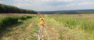
Topographic survey is geodetic work carried out by specialists in the field on a specific plot of land using geodetic instruments.
What types of shooting are there:
- altitude, during which elevations are determined;
- planned, in which the coordinates of points on the site are established;
- combined, combining the first 2 types.
During the survey, coordinates and heights of marks are obtained. The information received is subsequently processed by specialists who draw up an engineering topographical plan on a certain scale. As a rule, standard scales are used.
The choice of scale depends on the size of the area. The plan is issued to the customer in electronic or paper form.
What information may the plan contain:
- outlines of objects on the ground;
- operating and inactive engineering communications;
- streets, roads and sidewalks;
- fencing;
- shrubs and trees;
- relief.
Topographic surveys must be carried out under conditions established in accordance with regulatory documents. The engineering topographic plan must also meet legal requirements, otherwise the document will not be legal.
In 2021, the standards are established by the following documents:
- Civil Code of the Russian Federation;
- Orders of the Ministry of Economic Development No. 518 and No. 582;
- SP No. 11-106-97;
- Law No. 221-FZ;
- SNiP 11-04-2003.
Topographic survey work is carried out in 3 stages:
- Preparatory. During this process, a task is created for surveyors and an extract from the real estate cadastre is prepared. The information obtained is necessary for the next stage - work on the ground.
- Field. During this stage, specialists go to the site and conduct surveys using special equipment.
- Cameral. The information received is processed by specialists who draw up a plan that meets the client’s goals. The electronic document is sent to Rosreestr.
Responsibility for the performance of work lies with the cadastral specialist operating on the basis of a license.
Are you interested in establishing an easement on a plot of land? See here.
An engineering topographical plan may be required before a variety of land operations. It may be necessary both for small private plots and for large areas owned by construction corporations.
Several cases in which a plan is required:
- Connecting existing facilities to existing utilities.
- Implementation of landscape design.
- Laying new communications.
- Linking an object that is just under construction to existing objects.
- Reconstruction of existing buildings.
- Execution of earthworks.
A sample topographic plan of the land plot is here.
In order to order a topographic survey, you must contact the geodetic company at the location of the plot. When ordering a service, the client will be required to have a passport and land surveying documents that confirm ownership of the land.
Only land owners, but not land tenants, have the right to carry out land surveying. The cadastral engineer may request additional papers from the customer.
Documents will be required in any case when contacting a geodetic company. Land plots for which there is no documentation may be regarded as squatting.
Many land owners are interested in how much a topographic survey of a land plot costs.
The cost of geodetic work on the ground and drawing up an engineering topographic plan depends on several parameters:
- plot size;
- scope of work;
- the purpose for which the plan is needed;
- region, etc.
To a greater extent, the cost of work is influenced by the region in which the land plot is located. The highest prices for such services are observed in the capital and St. Petersburg.
Approximate cost:
- geodetic surveys and drawing up a site plan with an area of up to 10 acres will cost the customer 10,000-20,000 rubles or more;
- drawing up a layout plan for the site for connection to electrical networks and gas pipelines will cost approximately 6,000 rubles.
It is better to clarify the exact cost when contacting a specific company. As a rule, the customer is informed of a preliminary cost before the work is carried out.
An engineering topographical plan cannot be drawn up without geodetic surveys, which require the use of special and expensive equipment. Such activities are carried out exclusively by highly qualified specialists, as they must not allow any inaccuracies.
It is theoretically possible to carry out this work independently. But if you don’t have special education and appropriate equipment, then you shouldn’t try. Such actions may result in the survey project not meeting established requirements and not receiving certification from the appropriate authority.
It is much easier for the owner of the land to contact a specialized company, whose employees will carry out a set of works for a certain amount and present an engineering and topographical plan in good quality.
Before doing this, you can consult with a specialist in the field of land law. He will help you find answers to your questions and also provide recommendations for further actions of the land owner.
There are many companies on the market that conduct topographic surveys. Before concluding an agreement with any of them, it is worth checking the availability of a license. Another important criterion for choosing a company is the quality of the tools that employees use to take measurements.
What is a cadastral plan of a land plot? Information here.
How to find out the cadastral number of a land plot by address? Details in this article.
But if you have the desire and ability to independently draw up a topographic plan, then you need to:
- Copy the location of the plot from the cadastral map.
- Take the site location plan from the Rosreestr website.
- Draw boundary lines and highlight the plot.
- Set scale.
- Position the objects that are planned to be built, taking into account the indents from the red lines.
The result will be a plan that can be used for your own use, for example, for placing planned objects. But such a plan will not replace a document certified by Rosreestr.
- Due to frequent changes in legislation, information sometimes becomes outdated faster than we can update it on the website.
- All cases are very individual and depend on many factors. Basic information does not guarantee a solution to your specific problems.
That's why FREE expert consultants work for you around the clock!
- via the form (below), or via online chat
- Call the hotline:
- Moscow and the Region
- St. Petersburg and region
- Regions
APPLICATIONS AND CALLS ARE ACCEPTED 24/7 and 7 days a week.
Hello, dear readers of the HeatherBeaver online magazine! Do you have a plan? Do you have a topographic plan of the area for development? If there is, great! Check it for errors and start building! If not, read the article first.
From it you will learn how and why a topographic plan for construction is drawn up, and I, expert Viktor Golikov, will help you with this.
If you are planning to build a shed on a summer cottage, then you do not need a plan indicating heights, relief, soil and other components. But if a project is being created with the installation of utilities and further expansion of the building area, then the information from this article will certainly be useful to you!
Only thanks to the topographic plan are projects of complex structures created. Be it a power line, a transport highway, a residential building or an industrial facility. All structures that occupy a significant area are built on the basis of the topographic plan of the land plot.
This is interesting: Complaint against housing and communal services for power outages: sample 2021
A topographic map is drawn using a topographic survey of the area. During production, a special approved nomenclature is used (about 500 items). The difference between a topographic plan and other terrain plans is its altitude characteristics. On the plan you will always determine the height of a specific point and its elevation relative to the rest of the relief.
The plans note:
- hydrography (water bodies);
- soil and vegetation;
- terrain;
- transport interchange;
- engineering networks (including underground communications);
- structures (indicating the number of storeys and height characteristics);
- plot boundaries.
A map and a plan in topography are identical concepts. The difference is that the map is provided at a smaller scale and covers larger areas, taking into account the curvature of the surface of the globe. The plans do not take into account earth distortion and are carried out on large scales from 1:5000 to 1:500, i.e. the largest scale in demand is 1 cm. The plan is 5 meters of land.
- Holmes, don’t you know that the Earth is a sphere?
- Yes? But my eyes tell me otherwise!
- Right. Because you are a detective, not a topographer!
Topographic schemes must be tied to the existing coordinate system. If the plan is required for registration in the cadastral register, then it must be registered with the Geosurveillance Committee.
The joint implementation of geodetic work and topographic surveys reduces the cost of organizing research on land plots. And it significantly speeds up the execution of engineering and construction surveys for construction.
All plans differ from each other in scale and, accordingly, in detail. The smaller the scale, the more large objects are displayed on the plan. Larger scales carry more information load.
Depending on the detail of display, topographic maps are divided into several types.
Sounds solid. Looks the same! The most official topographic map. More than others, it requires approvals, stamps and accreditations. These plans are drawn up primarily at a scale of 1:500 and include underground utilities. All routes shown on the drawing must be agreed upon with the organizations operating them.
- Holmes, would you like to go through the sewer in order to mark the underground tunnels on the topographic plan of Baker Street?
- Perhaps! You know, Watson, we are also exploring the sewers!
Unlike other topographical diagrams, a geobase may contain several plans. Most often, these plans are carried out along with geodetic surveys and contain information about the geological composition of the soil composing the study area.
This type of plan is carried out to determine the contours of areas and objects located in the study area. The areas of land plots are also calculated and their relative positions are taken into account.
- Watson, give me the Atlas of Britain. And we will be able to consider Baskerville Hall in all its nuances! This is the most detailed topographical map of all of England. Ah, here is the gate near which Sir Charles Baskerville was found.
- Obviously, he was waiting for someone, Holmes!
- And you said that I don’t understand anything about topography!
A feature of horizontal photography is the lack of data on the terrain and elevations. Such plans are in demand when dividing land in dacha cooperatives or when determining the size of undeveloped land.
The most detailed maps are of this type. Performed in scales from 1:500 and larger (1:200, 1:100). The name speaks for itself. These diagrams are characterized by accuracy, detail and completeness of information.
Such topoplans display:
- vegetation;
- detailed relief;
- hydrographic elements;
- buildings and constructions;
- anthropogenic changes in the earth's crust.
The tree plan is used in landscape design, design of arboretums, as well as for landscaping work in cities and villages.
Topographical plans are required for the construction of residential buildings and structures that involve the accumulation of a large number of people.
For private needs and one-story construction, a plan is not at all necessary, but it will be useful when registering land for rent or ownership.
Any company engaged in geodetic surveys and registered in the SRO system (self-regulatory organizations) will complete a topographic plan for you. If necessary, register it with the necessary authorities (Geonadzor, Geofund, local departments of urban planning and architecture).
Choose an organization that carries out its activities as simply and transparently as possible, gives a guarantee for the work done and advises you on difficult issues.
If at a preliminary meeting they describe to you in simple and understandable language the essence of creating a topographic plan and, depending on your goals, help you draw up a competent technical task, then all you have to do is compare prices for services in similar companies.
The work to be carried out by the geodetic enterprise is determined by the customer based on its own needs. The list of surveys and their results are contained in the assignment, the preparation of which lies on the shoulders of the developer.
But often customers simply do not know what work is needed to achieve the desired result. Therefore, surveyors provide advisory assistance in determining the range of work.
Terms of reference for topographic survey are the primary fundamental document from which the formation of contractual obligations of the parties begins. In case of disagreement, all disputes and proceedings will take place with reference to this document approved and signed by both parties.
The contractual obligations of the parties are based on the terms of reference. This document defines the regulations for the work carried out.
It is reasonable and economical to conduct geological surveys along with topographic surveys. Companies that provide services for various land measurements are versatile and offer all the necessary measurements for developing site drawings.
When concluding an agreement, study customer reviews about the company. Pay attention to the timing of the work and the pricing policy of the company.
Follow the recommendations of surveyors:
- provide access to the research object;
- provide information about access roads;
- prepare existing documents about the site (even if outdated).
Initially, surveyors study terrain plans, compare them with technical specifications and determine a strategy. This is a necessary preparatory part of developing a plan. In the future, this will facilitate the work of specialists at the field stage of work.
Then follows a trip to the site - the object of measurement. Data is collected and recorded, thanks to which the topographic plan will be completed.
Let's look at the table of work carried out on a plot of 1 hectare:
Geodetic work forms the basic basis of the land surveying procedure. They are carried out in accordance with the purposes of land surveying. In more detail about the purposes of topographic survey of different types of land, as well as in general, what it is: we will describe topographic survey of a land plot in this material in detail and explain all the nuances and pitfalls.
What is a topographic survey of a land plot? This is part of the cadastral work performed during land surveying.
You can find out what land surveying is in this material.
It is carried out directly on the ground, on the basis of a technical specification previously drawn up by a cadastral engineer, using information about the site obtained from the state real estate cadastre (GKN).
Requires subsequent processing and calculations, on the basis of which a topographic document with explanations is compiled directly.
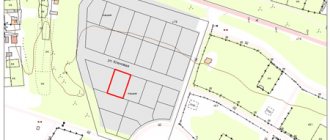
The customer is issued in the form of a boundary plan (topographic plan of the land plot), made in the form of a map-scheme of the land plot, with attachments in the form of text material. Depending on the purpose of the procedure, there are different types of boundary plans. The scale of execution is usually 1:1,200 or 1:1,500. In accordance with the specifics of the application for filming, it may change, focusing on legislative standards.
It is performed with modern DPS (satellite) equipment, which reduces errors to a minimum. For example, in Moscow, St. Petersburg and some other cities, land plots for housing construction allow errors in land surveying - up to 5 cm.
This is interesting: Form 9 certificate of registration: where to get it, validity period, sample 2021
Other types of surveys cannot allow such accuracy and allow arbitrariness in establishing boundaries and determining the location of objects on a site, which does not comply with the standards established by law. As a result, a cadastral error may occur that is difficult to correct.
The established standards are based on legislative regulations, which determine the performance of work and the conditions for their implementation in accordance with the following legislative acts:
Topographic survey compliance with the specified requirements is mandatory. Otherwise, the document will not enter into legal force and will not acquire legal capacity.
If you need to receive an extract from the Unified State Register in a short time, take advantage of the special offer from our partners below.
The result of a geodetic survey is always a topographic plan . But the customer can use it for various works carried out on the site. Because of this, in accordance with the purpose of the topographic plan, geodetic work is carried out on the site, followed by proper registration.
The difference in types arises due to the use of:
- various techniques;
- various equipment;
- scale requirements;
- permissible errors.
Here, photography will be required during the construction of capital buildings for housing and other needs , for example:
- warehouses;
- elevators;
- industrial and technical buildings.
Land surveying must be carried out before the start of construction and, on its basis, a project for the development zone must be prepared, including the building in the urban planning plan of the locality. The result is coordination of the new building in the context of the erected buildings and existing architectural solutions. Read about filling out the GPZU here.
The design of the development zone is carried out on the basis of the availability of a topographic document , which acts as a geological basis. Here, the buildings planned for construction are plotted on the existing land survey plan (see how to obtain it). Or an internal land survey is established for a plot that has been registered under a single cadastral number and is not subject to division. As a result, the planned ones appear on the memory diagram:
- buildings or structures;
- conditional boundaries of development zones;
- conditional boundary lines.
This procedure requires drawing up a situational plan for power supply or gasification of the plot . Here, in addition to the existing buildings within the site and beyond, transport lines are indicated, as well as the exact location:
- electrical wiring;
- gas pipes or other, in accordance with the application.
Such work is carried out in strict compliance of the manufactured circuit with the real state of affairs, requiring the utmost care in measurements and calculations. As a result, the customer receives a situational plan, which indicates the location of the electrical or gas infrastructure in the area where the charger is located.
This type of survey allows for a free increase in the site up to 10% of the total area (Article 60 of the Land Code). Or – the purchase of adjacent ownerless lands from the administration.
You can read the text of Article 60 of the RF Land Code below.
When carrying out geodetic work, a new site takes over the old territory. The topographic plan shows the initial and subsequent structure of the land.
Land Code of the Russian Federation, Article 60. Restoration of the situation that existed before the violation of the right to a land plot, and the suppression of actions that violate the right to a land plot or create a threat of its violation
- The violated right to a land plot is subject to restoration in the following cases:
- the court invalidates an act of an executive body of state power or an act of a local government body that entailed a violation of the right to a land plot;
- unauthorized occupation of a land plot;
- in other cases provided for by federal laws.
- Actions that violate the land rights of citizens and legal entities or create a threat of their violation can be suppressed by:
- invalidation in court in accordance with Article 61 of this Code of acts of executive bodies of state power or acts of local government bodies that do not comply with the legislation;
- suspension of execution of acts of executive bodies of state power or acts of local government bodies that do not comply with the legislation;
- suspension of industrial, civil, residential and other construction, development of mineral and peat deposits, operation of facilities, carrying out agrochemical, forest reclamation, geological exploration, prospecting, geodetic and other work in the manner established by the Government of the Russian Federation;
- restoration of the situation that existed before the violation of the right, and suppression of actions that violate the right or create a threat of its violation.
This procedure is carried out only by land surveying. Surveyors measure the total area of the merging areas into one, highlighting its boundaries along the perimeter. Or they divide one plot into a specified number of them, taking into account the norms established for this procedure.
Customers are provided with topographic documentation containing information about the old and newly formed site.
Read more here about the allocation of a share in kind of a land plot from the common shared property.
In addition to what is indicated, orders that are less common in everyday life, but still occur, arise. For information, please note that topographic survey is also required :
- When developing a master plan for the development of a settlement or designated area.
- Monitoring the profitability of planned work using geodetic measurements and calculations.
- Improvement of the territory of a settlement or local area.
- Forest cutting, allocation of forest area for logging.
- Survey work - drilling wells in accordance with geodetic measurements.
These works consist of three stages, in which topographic survey is the basic point, carried out only on the ground. In general, cadastral work consists of the following:
- Preparatory stage , at which technical specifications for surveyors are drawn up. An extract is ordered from the State Property Committee, and the information received is used to develop a preliminary plan. On its basis, work is carried out on the ground.
- Work on the ground - direct topographic survey with analysis of the information received and carrying out calculations. Turning points are recorded with signs, and their coordinates are transferred to paper.
Read more about the coordinates of turning points in our other article.
- The desk stage is the use of the obtained data in the preparation of a finished topographic document that meets the customer’s goals. Preparation of a cadastral report, with the transfer of an electronic version to Rosreestr.
The application is submitted to the geodetic company at the location of the landfill. It is accompanied by land surveying documents confirming the ownership of the site and the customers’ passports.
Prices for the designated work are set depending on regional prices, taking into account the profitability of the company and the list of services provided.
In particular, the highest prices for the cost of topographic survey of a land plot are in Moscow and St. Petersburg, approximately for different types of services they are:
- Cadastral work on plots up to 10 acres - from 10-20 thousand rubles , depending on the location of the land plot. As the area increases, prices increase.
- Drawing up a boundary plan for a building up to 200 m - from 8-10 thousand .
- Establishing turning points, if the site has no more than four of them - from 8-14 thousand , depending on the location.
- Drawing up an SPRSU for electrification or gasification of a charger - from 6 thousand .
When ordering geodetic work, you should take into account their complex, which makes up the package of services received. You also need to take into account the availability of a license and the quality of the equipment with which the work performers carry out measurements.
Sometimes citizens prefer to create a topographic document themselves in order to save money. In practice, such an action is acceptable. But it should be taken into account that the initiators of independent filming do not have satellite equipment, which distinguishes them from experienced specialists.
Therefore, for independent work you need:
- Copy the location of the storage unit from a satellite map, which can be found in a search engine for “cadastral map” or “official website of Rosreestr”.
- On the official website of Rosreestr, find and copy the site location plan.
- According to the boundary plan, draw boundary lines on the cadastral map, highlighting your own area with extreme accuracy.
- Set the required scale.
- Place the planned development on the resulting cadastral map, observing the offsets from the red lines and other stipulated standards.
Despite the official invalidity of such a plan, it is permissible to prepare it for your own use. For example, for marking buildings or other areas. But we should not forget that it does not replace an officially certified document by the department of urban planning and architecture or Rosreestr.
The production of a topographic document requires a topographic survey of the area, with a reliable determination of the boundaries of the land plot and other parameters.
Find more information on the topic “Land Surveying” in our section.
Good day everyone! It's time to figure out the topographic plan. What is it and what do you eat it with and what do you eat it with?
And in general, is it really necessary to contact the geodetic service or private owners (with a license) to “draw” a primitive plan for your own piece of Russian land?
Yes, yes, yes, and yes again - without a topographical plan of the site, no one will ever allow you to build not only a dream house, but a hut on chicken legs (even if your beloved mother-in-law likes to fly in a nano-mortar in her spare time).
Science defines the concept of “topography” as a branch of geodesy that deals with measuring mother Earth and depicting it on maps. Since we are interested in the topographical plan, obviously, the measurements will not concern the entire blue planet, but only that piece of it, which is your sole and indivisible property.
Moreover, in fact, a topographic plan is not even a “primitive” diagram, but a drawing set of contour lines, designations of all elements and objects, as well as relief marks located on your territory.
For any plan, it is important to choose the right scale. When they make a topographical plan (and, as we have already found out, surveyors do this), they usually use a “five hundred” to develop a construction plan. So in professional slang, level and theodolite workers (without them a surveyor is like an astronaut without a spacesuit) call the scale 1: 500 (i.e. 1 cm on paper corresponds to 5 m on the ground).
The topographic plan looks like this:
Obviously, in order to obtain data from which it will be possible to draw a plan of your territory, you first need to make certain measurements, for example:
If you become the owner of not just a measly few hundred square meters, but a nth part of the region (yes, some people are lucky!), in this case, the surveyor will not go “out into the field” on his own two feet, but at a minimum, fly in a light airplane while performing aerial photography. Or uses a drone with special built-in geodetic equipment.
But if this is not your case, then everything will be simpler and cheaper. Therefore, before starting “field” work (as measurements on the ground are called), surveyors make a alignment base - an aid to this very topographic survey.
! Topographic survey is carried out using an electronic total station and a navigation receiver, which identifies the boundary coordinates of points. !
In order for the topographic plan of a site to appear on paper, it is necessary not only to survey “in the fields,” but also to perform office work. They have the same relationship to chamber music as a lion cub has to Google: by this term, geodesic engineers understand the execution of calculated data that is obtained using computer and special graphic programs.
So, so as not to make a fuss in vain, not to order too much and not to find yourself without what you need, remember: there are only 5 cases when a topographic plan will become a vital piece of paper:
- To obtain permission to construct a capital facility. No, of course, you can build a “self-construction” on your own site, having all the permissions for development in mind. But know: when the time comes to sell, donate, or otherwise legally deal with your own farmstead, you or your heirs will be in for another unpleasant surprise... So it’s better to still make a topographical plan - it’s calmer that way.
- Don't build anything yet, let it be. But to begin with, to make a project for the future “family farmstead” with buildings, also without a topographic plan of the site, neither here nor there.
- If everything has already been built and built on your own land, and you have an urge to connect to centralized sewer, water or gas lines, you can rest assured that without a topographic plan there is no point in going to the specialized operating organizations. By the way, if you decide to redesign underground communications, also make such a plan.
- Do you dream of legitimizing “extra” acres under the “dacha amnesty”? Why dream - make a topographic plan, and go ahead - with blessings and prayers!
- When the house is standing, the bathhouse is heating, and tomatoes are ripening in the greenhouse, it’s time to think about landscape design. This is why they order a landscape topographic survey, which is used to make a topographic plan of the same name. True, it is more detailed, in M 1: 100 or 1: 200 (so that every bush and tree would be clearly visible).
! In general, remember a simple truth - without a topographic plan, you will not see the cadastral plan, like your own blades. !
Today there are a lot of private geodetic organizations and individual geodetic engineers who are ready to perform topographic surveys and office work and create a topographic plan of the site as the final result of the labors of their righteous ones. But do not forget to ask both of them for a license for such types of work.
And in order for an organization or individual to start work, they must provide them with the following documents:
Everyone's plan is different. Well, firstly, every work is evaluated in its own way. Secondly, the final price depends on the volume of work and the area where it is performed. It is clear that in the capital this is one kind of money, but in the Siberian wilderness it is different. Moreover, the ruble and dollar today, I remember, have created such a “swing” that to name a number would deceive you.
Therefore, let’s say this: the cost of a topoplan for both “offices” and individual entrepreneurs depends on:
- scale;
- area of territory;
- on the number of permanent buildings;
- distance from the city;
- the length of underground communications on the site;
- receive your order in paper or electronic form;
- terrain.
! By the way, there is one good news - the cost of this work does not depend on the season - in winter and summer you will get by with one “ruble color”. Well, if the “green” one doesn’t let you down, of course!
And when the coveted topographical plan of the site warms your hands, do not keep it with you like your beloved - take it to the architectural department, which is located in the local government, and you will be happy...
For those who like to delve into regulatory documents, I post the law on geodesy and cartography.
»
Documentation
Act on disconnecting electricity for non-payment: sample 2021
Read more
Documentation
Assigning an address to a house on a plot of land: procedure, documents 2021
Read more
Documentation
Minutes of the general meeting of owners of an apartment building: sample 2021
Read more
Great article 0
Assistance in conducting geodetic surveys - review of the TOP 3 companies providing services
Do you need help with geodetic surveying, but don’t have time to look for a reliable organization?
Take advantage of the review in our magazine - we have selected 3 professional Russian companies with the most favorable terms of cooperation.
1) Geodetic
An exceptional group of professionals, assembled from graduates of the best Russian universities. Provides a full range of geodetic services for all segments of society. The key to the company's success is a highly qualified approach to work. Fast and high-quality solution of problems is the active position of the company's employees.
You wish:
- conduct a geodetic survey of the site;
- draw up a general plan of the area;
- draw up a situational plan;
- create the basis for the construction project.
You can get all this from the geodesic. Your cooperation will be as comfortable as possible with your future!
2) Main Measurement
The company positions itself as a leader in performing any geodetic work on the market of the Moscow region. Specialists will be able to go to the research site during the day.
Possessing the most modern equipment, the organization’s specialists guarantee that your orders will be completed as quickly as possible.
GlavOmer will make engineering and geodetic measurements of your territories in the shortest possible time at the lowest prices.
3) Almax Geo
A sought-after company providing geodetic services. The company’s employees will help you effectively and quickly solve the problem of topographic survey of a land plot.
Modern tools used by Almax Geo employees will help you quickly take measurements and draw up a geodetic basis plan for further design of construction on your territory.
Is there a need for geodesy? Contact a company that will take all the measurements for you and provide a report in paper and electronic form. Almax Geo will make your land plot acceptable for designing further development.
How to avoid mistakes when conducting geodetic surveys - 4 useful tips
Here we will look at how to speed up as much as possible and avoid unnecessary expenses when carrying out geodetic work.
Useful tips for organizing geodesy of your land plot.
Tip 1. Order the service on time
We pay attention to the area and quality of construction. Measuring an area in a field and carrying out work on a built-up area are two different things.
If in the first case we simply draw up a map of the boundaries of the site, then in the second we will also have to photograph buildings, supply routes and access routes.
A simple contour survey of a standard plot of 10+ acres will take a couple of hours, but if it is necessary to include all the buildings with details on the plan, this is a completely different time. Therefore, consult surveyors in advance.
Tip 2. Use the services of only qualified specialists
Carrying out geodetic work requires specialized licenses. Contact companies that have experience and have proven themselves in the geodesy services market.
As a rule, such companies provide comprehensive services, including cadastral work, which is primarily necessary for engineering work on a land plot.
Tip 3. Clearly define for what needs the shooting is being carried out
Let's face it, you don't think much about your shed layout. But planning your home takes up all your time. And here there is the same dependence. Initially, you need to determine the purpose of the work being carried out.
Shooting the drawing is different!
The diagram will help you in designing what is planned in relation to other objects on the site and the surrounding area. In addition, correctly set goals will reduce the cost of surveyors’ work.
Tip 4. Avoid shooting in winter
This is the rake that everyone steps on! In order not to disturb the neighbors and residents of the dacha, they order filming in the winter. Well, you must understand that the snow cover hides all the subtleties of the relief.
The same shooting on snow and on the ground will show different results. The top layer of soil is frozen and soil deformation is obvious. In winter conditions, it would be wise to survey only the boundaries of the site or a contour plan.