General information about topographic survey
Since topographic survey is a mandatory stage of any geodetic work, first you should understand what topographic survey of a land plot is. According to, topographic survey is a set of works that allows you to obtain detailed topographic maps and plans of the area, as well as collect other information that will form the basis for geodetic calculations.
Given the development of technology, various geodetic and cartographic equipment are used in topographic surveys using a wide range of techniques.
Conducting topographic surveys is the responsibility of surveyors. Only they have the necessary knowledge and skills to perform the following tasks:
- calculation of coordinates on the ground;
- measuring distances, angles and heights;
- measurement of other quantities;
- transferring them to a topographic drawing.
These measures make it possible to take into account all the landscape features that will be important during the construction of objects or other intended use of the land.
Thanks to painstaking work and high-precision equipment, surveyors are able to plot the exact terrain on the plan, indicating:
- highest and lowest points;
- all vegetation;
- buildings;
- engineering communications;
- other significant objects and their features.
Based on the survey results, a topographic map of the site is formed at a scale of 1:500 or another. But the presence of a map does not mean that all measurements were made correctly. A drawing (or a plan in another form) becomes valid only after it has been agreed upon with the companies operating utilities.
Not only ground, but also underground communications should be measured and plotted on the plan.
At the request of the customer, individual objects, symbols and other features can be applied to the drawing.
If a topographic survey has already been carried out and landscape changes do not exceed 35% in fractional terms, adjustments to the previously compiled topographic map are permissible.
Who needs topographic survey and when?
Many people believe that topographic surveying is an urgent need exclusively for construction companies, or companies associated, for example, with the arrangement of engineering systems. However, it is also necessary on a less global level. So, if you own even a small plot of land, sooner or later you will need a topographic survey. It is needed not only to obtain a GPZU, but will also be useful in case of controversial situations. For example, disagreements may arise with utility services or neighbors regarding the boundaries of a land plot. If you have a topographical plan, you can easily prove that you are right. In addition, the document is necessary to solve many other organizational, technical and legal problems.
Topographic survey for engineering and technical communications
This service is necessary when you plan to install new communications, redesign or reconstruct old systems. Regardless of what exactly you need - gas, water, sewerage or telephone - the operating services will ask you to provide a plan for the location of existing networks, as well as other facilities located on the site. This is necessary for further creation of a project for connecting communications, determining locations for laying pipes, etc.
Preparation for landscape design
There are no strict norms or rules from the state regarding the improvement of the territory. However, if you are planning a large-scale project involving, for example, landscaping, green spaces, lighting and other decorative objects, it will be much easier for the contractor to cope with the task if you have an up-to-date topographic plan. This will allow you to design the arrangement of all elements in more detail and ultimately obtain an ideal result.
Surveying a site for a master plan of the territory
Territorial planning of a settlement is based on the general plan of the area. A settlement can mean a village, a city, a dacha cooperative or a gardening partnership. The development of such documentation is carried out by design organizations. At the same time, to obtain a master plan, topographic surveys are used, which allows one to obtain the maximum necessary data about the study area. Plans with a scale of 1 to 500 are usually used.
Calculation of the volume of excavation work
To draw up an excavation project, or to calculate the work done, topographic survey is the most convenient tool. Elevation marks on the resulting plan allow you to carry out the necessary calculations with high accuracy. You can resort to the services of surveyors, both at the design stage and during earthworks. This will be an additional check on contractors. For large volumes, it is recommended to carry it out systematically.
Creation of project documentation
In order to be able to draw up design documentation for any construction project, it is necessary to have detailed information about the construction site itself, that is, about the land plot on which the new building or structure is supposed to be located. The source document in this case is the topographic plan. A drawing of the object is applied to it with reference to the boundaries of the land plot. Accordingly, when planning a development, the sequence of actions will be as follows:
- Ordering and conducting topographic survey of the site.
- Creation of project documentation.
- Obtaining a building permit.
Fundamentals of legislation
The basis of the legislation in accordance with which topographic surveys are carried out is. They approved:
- basic principles of topographic survey and creation of topoplans;
- the order of use of the main metric values;
- content of topoplans;
- the procedure for their registration and updating;
- the procedure for carrying out certain types of shooting;
- methods and purposes of collecting topographic information.
To detail the technical requirements set out in the Basic Provisions, a detailed Instruction for topographic survey was developed and approved. It describes on 98 pages:
- Engineering and topographical plan of the land plot.
- The procedure for designing and collecting topographic information.
- Features of reconnaissance, triangulation, leveling.
- Types of topographic signs.
- The procedure for drawing up technical requirements and so on.
The remaining regulatory legal acts relate to topographic surveys only indirectly.
What is GPZU?
Despite the fact that the services of surveyors are required for many other tasks, the main focus remains topographic survey of the site for the GPZU (urban planning plan of the land plot). This document is required to obtain a building permit. It contains complete information about the area, including:
- Data on the location of the study area.
- Information about the presence or absence of security zones near the facility.
- Building density.
- Permissible height and number of floors of capital construction projects that will be located on the specified territory.
- Information about existing buildings and structures.
- Permitted options for using the land.
Other information may also be indicated, which will be posted in the recommendations section.
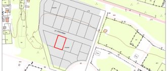
Those areas where construction is permitted are marked in red on the plan. They usually represent lines beyond which planned buildings should not protrude. Behind these lines there may be pedestrian and highway roads, public facilities, etc. There are also separate so-called sanitary zones, which can be used for housing construction, but the construction of industrial facilities on them is prohibited.
In order to determine the area where the building can be located, the designer will need an up-to-date topographic plan of the area. It is submitted to the relevant government authorities along with the application for a building permit.
It is worth noting that the urban development plan is far from an empty formality for obtaining a building permit. It also contains a lot of useful information that will be needed at the building design stage. So, for example, GPZU will allow you to optimally solve the following problems:
- It is rational to place the construction project in relation to existing buildings.
- Avoid getting into technogenic zones, urban planning regulation lines (protection zone of a high-pressure gas pipeline, high-voltage power lines, etc.).
- Designate a construction site away from hazardous natural areas with unstable soil, risk of flooding, etc.
- Comply with fire safety requirements.
- Observe the permissible height and number of storeys of the building, in accordance with the terrain.
Classification of topographic survey
Topographic surveys can be classified according to several parameters. Depending on the method of implementation, a distinction is made between ground and aerial topography.
Aerial surveying is used to carry out large-scale measurements, for example, topographic survey of a land plot for the state land plot. It is carried out using aircraft, including spacecraft.
Ground survey is a fundamentally different type of collecting topographic information by leveling. Its purpose is to determine the location of elevation projections of terrain points on the horizontal surface of the earth.
Another classification criterion is the shooting scale. The smaller it is (the larger the denominator), the larger the shooting goals should be. The following types of plans are distinguished:
- A plan with a scale of 1:5000 is used for:
- approval of the city general plan;
- design of large industrial enterprises;
- detailed planning of undeveloped areas;
- drawing up projects for irrigation of agricultural plots.
Such a survey is carried out to approve utilities, for example, a topographic survey of a land plot for gasification.
- The plan on a scale of 1:2000 is used for: developing master plans for urban settlements and urban areas;
- drawing up plans for mining enterprises;
- calculation of mineral reserves for medium-sized deposits;
- development of railway junction diagrams and so on.
- creating a general plan for low-rise buildings;
- underground networks;
Topographic surveys of the site for the urban planning plan are also carried out at this scale. Such surveying must be justified by surveyors.
The next classification criterion is the shooting process and the equipment used. Most often used:
- Stereotopographic survey. Thanks to stereo pairs, surveyors determine the plan and elevation position of terrain points, and then transfer it to the plan using stereoscopic drawing.
- Theodolite survey. This type of ground survey is used to obtain a contour plan of an area using a theodolite and rangefinders. This survey does not take into account the altitude characteristics of the relief, and therefore is usually used on flat terrain.
- Compass survey: a type of ground survey of small areas using a compass and rangefinders. Used for quick shooting with low accuracy.
- Sonar survey: a separate type of survey for underwater reconnaissance using a sonar attached to an underwater craft.
- Aerial photography: A type of aerial photography that produces large-scale topographic images of an area through the use of UAVs or space probes.
- Digital topographic survey. Special equipment is used that projects graphic forms of the terrain into digital models.
Read more in the material “Geodetic Survey of a Land Plot”.
Types of topographic plans
There are several ways to divide topoplans. One of the signs on the basis of which they are divided is the nature of the information that is displayed on it - they can be:
- Basic , when all information on the site is reflected;
- Specialized . In such a situation, only the data that the customer needs in connection with the specific purpose of using the allotment is indicated.
In addition, plans can be divided according to the scale of display of objects on them. The main types of plans that are most widely used are:
- Geobase;
- Horizontal survey plan;
- Tree plan.
Geobase
The geobase is one topographic plan of the area of interest or several of its displays .
Moreover, each of a certain number of documents can be of a different scale.
In most cases, they are used to create reconstruction plans, technical projects, master plans of the construction area, various intermediate and working drawings.
The geobase is characterized by the fact that it is somewhat different from standard documents in that it displays objects not only those located on the surface of the earth, but also those that pass under a certain layer of the earth.
Horizontal plan
This type of topoplan is defined as one that allows you to create a contour plan of the area . The shooting is carried out in areas that are already built-up, and they contain a large number of different objects with various shapes and contours.
This survey is most often carried out in populated areas, areas located within the plain or those that include railway junctions.
In addition, this type of plan is often used when establishing the boundaries of lands, calculating their size and location relative to each other. A characteristic feature of such surveys is the complete lack of information about the topography of the site .
Wooden
Such a document refers to the most detailed way of displaying what is located on a piece of land. This plan is being implemented on a larger scale than all others - 1:100 – 1:500.
These types of plans display:
- Detailed terrain;
- Existing vegetation (trees);
- Elements of hydrography;
- Located properties;
- Changes that have occurred in the earth's crust that are anthropogenic in nature.
This type of plan has found the greatest application when carrying out work on landscaping areas and designing arboretums under construction.
Why may a site survey be required?
There is a huge range of purposes for which topographic survey of a land plot is needed. This includes the preparation of cadastral maps, master plans, plans for large industrial enterprises and infrastructure projects, roads, metro stations, large-scale housing developments, and so on.
But topographic surveys may also be required for ordinary citizens, in particular for:
- Registration of a land plot for primary cadastral registration. The survey will allow you to draw up a detailed cadastral plan indicating the boundaries of the site, determining its area and placing boundary markers in nature.
- Gasification. As a result, a site plan is created, on the basis of which the gas pipeline is designed. It displays the gas pipeline system, which is subsequently approved by the service organization. Such situational topographic plans are also created when designing other utilities.
- Urban planning plan. A topographic survey for the urban planning plan of the land plot will be required to obtain a building permit. The plan displays the site on the required scale, along with the buffer zone around it, agreed utilities and cadastral land use boundaries.
- Redevelopment or land surveying. In this case, topographic survey allows you to draw up a detailed plan of the site, determine its regulatory boundaries, or divide it into several equal parts. At the same time, it is worth understanding what land surveying and topographic survey are, what is the difference between them. These are completely different concepts: if surveying is a geodetic procedure for determining the boundaries of a site, then topographic survey is a method of determining boundaries within the framework of surveying.
- Landscape design. One of the types of highly detailed photography, which displays all vertical elements, tree plantations, buildings, communications and other important details.
Situations in which topographic survey is necessary
Obtaining a building permit
Here, photography will be required during the construction of capital buildings for housing and other needs , for example:
- warehouses;
- elevators;
- industrial and technical buildings.
Land surveying must be carried out before the start of construction and, on its basis, a project for the development zone must be prepared, including the building in the urban planning plan of the locality. The result is coordination of the new building in the context of the erected buildings and existing architectural solutions. Read about filling out the GPZU here.
Preparation of a survey project
The design of the development zone is carried out on the basis of the availability of a topographic document , which acts as a geological basis. Here, the buildings planned for construction are plotted on the existing land survey plan (see how to obtain it). Or an internal land survey is established for a plot that has been registered under a single cadastral number and is not subject to division. As a result, the planned ones appear on the memory diagram:
- buildings or structures;
- conditional boundaries of development zones;
- conditional boundary lines.
Sometimes such a document is used to establish encumbrances on part of the land plot.
Conducting communications
This procedure requires drawing up a situational plan for power supply or gasification of the plot . Here, in addition to the existing buildings within the site and beyond, transport lines are indicated, as well as the exact location:
- electrical wiring;
- gas pipes or other, in accordance with the application.
Such work is carried out in strict compliance of the manufactured circuit with the real state of affairs, requiring the utmost care in measurements and calculations. As a result, the customer receives a situational plan, which indicates the location of the electrical or gas infrastructure in the area where the charger is located.
Making cuts
This type of survey allows for a free increase in the site up to 10% of the total area (Article 60 of the Land Code). Or – the purchase of adjacent ownerless lands from the administration.
You can read the text of Article 60 of the RF Land Code below.
When carrying out geodetic work, a new site takes over the old territory. The topographic plan shows the initial and subsequent structure of the land.
Reorganization of the storage facility
This procedure is carried out only by land surveying. Surveyors measure the total area of the merging areas into one, highlighting its boundaries along the perimeter. Or they divide one plot into a specified number of them, taking into account the norms established for this procedure.
Customers are provided with topographic documentation containing information about the old and newly formed site.
Read more here about the allocation of a share in kind of a land plot from the common shared property.
Other types of work
In addition to what is indicated, orders that are less common in everyday life, but still occur, arise. For information, please note that topographic survey is also required :
- When developing a master plan for the development of a settlement or designated area.
- Monitoring the profitability of planned work using geodetic measurements and calculations.
- Improvement of the territory of a settlement or local area.
- Forest cutting, allocation of forest area for logging.
- Survey work - drilling wells in accordance with geodetic measurements.
The procedure for conducting topographic surveys
Surveyors, cadastral engineers and everyone who makes a topographic survey of a land plot must adhere to a certain procedure for conducting it, which depends on the type of survey, its purposes, scale and other features. But still, GKINP-02-033-82 allows us to highlight the general procedure for conducting topographic surveys.
The procedure can be divided into three stages:
- Preparation. It begins from the moment the owner or other interested party contacts surveyors. An agreement is concluded between them, technical specifications are drawn up, the specifics of the situation are worked out, a package of documents is collected, and a preliminary topographic plan is drawn up based on cadastral information. At the same stage, a permit for topographic work is issued at the local urban planning department, and the location of ground and underground communications is agreed upon.
- Field work – carrying out topographical activities on the ground. Specialists examine the site, select survey support points, calculate the height of geodetic signals, carry out and record the measurement results.
- Office information processing. This stage determines the results of the topographic survey. Surveyors process the collected data, build a digital model of the area, draw a plan with relief and underground utilities. Then the plan is approved and only after that the report is sent to the customer.
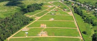
Now let's figure out what a topographic survey of a land plot looks like.
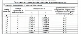
Elements of the topographic plan
The result of any topographic survey, regardless of its type and methodology, is a topographic plan. It is a reduced and generalized schematic plan of the area, which ensures maximum accuracy in transferring the surface of the earth's ellipse to the map plane. Below you can see a sample plan, but first let's look at its main elements:
- The grafical part. The basis of the plan, on which, according to §13 GKINP-02-033-8, settlements, individual buildings, industrial and other facilities, road networks and infrastructure structures, terrain, vegetation, soils, and so on should be reflected.
- Mathematical basis. This is a set of criteria by which the relationship between the graphic part and the real land plot is determined. We are talking about the geometric display of mathematical laws, the measurement of coordinates and other features. This includes scale, projection, grid, rationale, and so on.
- Conventions. Signs that briefly indicate objects on the plan, the type of vegetation, soil or relief, heights, roads and everything that does not need to be indicated in detail on the map.
- Additional data: site address, height and coordinate system used, performer of field and office work, etc.
Next, we suggest you figure out where to get a topographic plan of a land plot.
Legislative aspects
The wide scope of application of topographic survey results is due to the presence of many regulations governing the organization and conduct of work. Specific regulations are presented in the table.
| Document type | List of documents |
| Federal laws |
|
| Codes of the Russian Federation |
|
| SNiP |
|
| State standard |
|
| Instructions |
|
These documents reflect specific requirements and recommendations for organizing work, conducting surveys for various purposes, as well as presenting survey results.
Organization and execution of work
To compile maps and diagrams, survey types of various scales are used. Modern equipment allows shooting at the following scales:
- small (1:10000, 1:25000)
- large (1:500, 1:1000, 1:2000, 1:5000)
- extra large (1:50, 1:200)
Topographic survey is carried out in 3 stages.
Stage 1 – preparatory. It includes the development and provision of technical specifications by the customer, analysis of previous geodetic surveys and obtaining permission to carry out work. At this stage, the interaction between the customer and the contractor plays an important role. The more complete and detailed the technical specifications are, the better the results will be.
Stage 2 - field. The site is inspected, geodetic reference points are selected, all necessary measurements are taken: elevation differences, distances, buildings, structures, underground communications, etc.
Stage 3 – desk. The previously obtained data is analyzed and processed, and a topographic plan is drawn up based on these results.
The result of the research is a package of technical documents, which is transferred to the customer. This includes copies of topographic surveys and technical reports, as well as the engineering topographic plan itself on paper or digital media.
Please pay attention to the details of obtaining permission to build a private house. And here you will find the features of a military mortgage in 2014.
Permission and approval - what's the difference?
Topographic surveying is carried out only with special permission from the city department of architecture, or from the cadastre, geodesy and cartography service. To obtain a permit you must present:
- application for work
- estimate
- technical task
- agreement
- license
- work program
Obtaining permission should be treated very carefully, since filming performed without permission simply will not pass approval, which means it cannot be used for its intended purpose. In some cases, permission is not required (for example, if topographic survey is carried out to meet the personal needs of the customer), but it is better to clarify this point.
Coordination of topographic survey is the final procedure before issuing documents to the customer. Its essence is that surveyors, after field and office work, must visit all public utilities in the area and check that communications are correctly applied to the plan. Each service puts an approval record and its own stamp on the documents. After this procedure, a single technical report is prepared, which is certified by the Department of Architecture and the Urban Planning Committee. Only now is topographic survey considered officially completed and its use becomes possible.
A complete list of cases in which mandatory approval is required at construction sites is enshrined in Decree of the Government of the Russian Federation No. 145 of March 5, 2007.
How and where to order a topographic plan
Only surveyors and cadastral engineers who have passed a qualification exam and received the appropriate certificate can engage in topographic surveying.
When choosing where to take a topographic survey of a land plot, the customer must proceed from the availability of an expert organization or private surveyors:
- Certificates of admission to certain types of work that affect the safety of development sites. Such a certificate serves as a license to carry out topographic work. It is issued by a self-regulatory organization of persons carrying out engineering survey work.
- A qualification certificate for a cadastral engineer and certificates of advanced training confirming the ability to carry out engineering survey work in construction.
- Certificates of membership in SRO. Membership in a self-regulatory organization of cadastral engineers is a prerequisite for legal activities. Without this, the implementation of cadastral and topographical work is unacceptable.
- Certificates of verification of topographic instruments. The presence of such evidence is not necessary, but verification allows you to count on the accuracy of the information.
The service can be ordered by phone or at the surveyor's office. Most reputable geodetic organizations use information resources, so it is possible to order a topographic survey of a land plot online. And yet, you cannot do without a personal meeting, signing an agreement, drawing up technical specifications and other communications with an expert.
Carrying out topographic survey work
These works consist of three stages, in which topographic survey is the basic point, carried out only on the ground. In general, cadastral work consists of the following:
- Preparatory stage , at which technical specifications for surveyors are drawn up. An extract is ordered from the State Property Committee, and the information received is used to develop a preliminary plan. On its basis, work is carried out on the ground.
- Work on the ground - direct topographic survey with analysis of the information received and carrying out calculations.
Turning points are recorded with signs, and their coordinates are transferred to paper. Read more about the coordinates of turning points in our other article. - The desk stage is the use of the obtained data in the preparation of a finished topographic document that meets the customer’s goals. Preparation of a cadastral report, with the transfer of an electronic version to Rosreestr.
Each stage of work is provided with appropriate methods of carrying out and calculations, as well as the necessary tools. Responsibility for their implementation rests with a cadastral engineer who has a license to conduct them.
Do-it-yourself topographic survey
Topographic survey is the work of qualified specialists with higher specialized education and specific qualifications. However, there are many advisers on the Internet who tell you how to make a topographical survey of a plot of land yourself, although this is impossible even theoretically. If in doubt, please remember:
- Only persons who have received a qualification certificate and a certificate of admission to such work have the right to carry out topographic surveys;
- in the process of topographic survey, specific equipment and complex topographic software are used, which is impossible to operate without special skills;
- based on the results of the topographic survey, a topographic plan is drawn up, which cannot be created without special knowledge in cartography and geodesy;
- The topographic plan is subject to approval by the operating organizations, but without submitting the necessary certificates and approvals it is simply impossible.
How is topographic survey for GPZU carried out?
If you plan to build a house or other capital construction project on your property, you will need to provide a topographic plan of the area. To do this, you should invite a surveyor of appropriate qualifications, who, using special equipment, will survey the situation and topography of the site. The result will be a document containing information about all objects located on the site, as well as under it (utility networks).
To obtain a building permit, generally accepted survey scales are used - 1 in 500, 1 in 1000 or 1 in 2000. They make it possible to display all the features of the relief and the site itself. At the same time, high-quality topographic survey will help not only with permitting documentation, but will also become the basis for the design of the future structure. The availability of detailed information about all the dimensions of objects and the distances between them will allow us to determine with high accuracy the location of the building and all its elements.
Costs for topographic survey
How much a topographic survey of a plot of land costs depends on many factors:
- land area - the base rate for topographic work is tied to the cost per 1 hectare;
- degree of development of the site - the more buildings on the site, the more complex the work and the higher the cost;
- shooting season - in the cold season, increasing coefficients are applied;
- shooting purposes - they determine the degree of accuracy and detail of the plan: the higher it is, the more expensive the service;
- the need to display utility lines - they all require approval, which entails additional costs, increasing the final cost of topographic work;
- terrain of the site - the simpler it is, the fewer measurements and the lower the price.
The specialist’s remuneration is determined based on the estimate of the work performed. The final price is determined for each case individually, based on a thorough analysis. Depending on the region and the purpose of the shooting, it can range from 10 to 40 thousand rubles.
Definition of topographic survey and topoplan
Topographic survey or topographic survey, as it is more often called, refers to the carrying out of certain works characterized by the precise measurement of the parameters of the earth's surface and the objects located on them.
This is carried out for further use when performing any types of work on the land in accordance with the permitted type of land use (which will correspond to the intended purpose of the site).
The production of a document involves the accurate transmission of all necessary data and can be provided in three different scales - depending on the accuracy required by the customer.
The plan prepared and drawn up by the contractor must include the following objects :
- The terrain of the plot of land, the plan of which was ordered to the contractor;
- Communications and any engineering structures passing through the site;
- Boundaries of plots, lands, territories. There may be a division according to purpose, intended use, etc.;
- Information about the altitude parameters of natural and artificial objects located on the land plot.