Who has the right to conduct an expert assessment?
In Russia, the urban planning cadastre is carried out by a multi-level organization. Objects are considered at the following stages:
- Russian Federation.
- Subjects of the Russian Federation.
- Administrative districts.
- Settlements.
The need for division comes from the requirement for leadership positions to monitor their territory and update information up to date. After the procedure at one of the levels, information flows higher, replenishing the all-Russian register.
But the work itself is carried out by private companies. The company must have a license to operate, and engineers must receive appropriate education. This is an important document; if it is filled out incorrectly, the interests of the state may be affected.
An authorized person contacts companies to update cadastre data. This often occurs when there are changes in infrastructure, planning for new construction, when recalculating the budget, or when allocating money for the construction of a new public or other building. A municipal order can be assigned to an organization or a private entrepreneur. The deadlines are specified in the terms of reference; they are calculated individually depending on the scope of work (cadastral block, street, locality), but cannot exceed 7 months from the date of conclusion of the contract.
What is carried out when performing complex cadastral works
There are several services that the authority provides.
Registration
This is a labor-intensive process, as it requires collecting a large package of documentation. It includes lists, charts, tables, reports. The main difficulty is the correct design.
The ProGeo program from ZVSOFT has a complete list of all requirements; the software allows you to automatically create documents. The ProGeo module “Comprehensive cadastral works” is entirely intended for the KKR in accordance with the order of the Ministry of Economic Development of Russia dated November 21, 2016. In the program you can:
- Automatically fill in data about the customer and source documents;
- add contours of land plots and capital construction projects;
- create tables about adjacent cadastral blocks in order to prepare an act on the approval of boundaries;
- automatically prepare the text part;
- create boundary diagrams and geodetic constructions in the ZWCAD program.
All buildings are subject to accounting - residential, non-residential, industrial, public and others.
Work order
Each action includes a clearly structured algorithm of actions. Cadastral works are no exception. The legislator has fixed this list.
Stages of cadastral work in accordance with Art. 42.6 Federal Law No. 122-FZ:
- To carry out the required set of works, the customer needs to draw up an application. With a detailed description of the work that needs to be carried out by the cadastral engineer. To do this, you can contact a state company or a company that has a license to provide such services.
- At the next stage, a specialist goes to the work site. His responsibilities include: obtaining cartographic materials, collecting data about the object, analyzing the presence, absence and location of communications, obtaining legal documents for the object, information about neighboring objects. After carrying out the necessary work, the customer and the contractor sign a service agreement reflecting the conditions and prices for the ordered work.
- Work on an object includes recording its measurements on a medium, that is, examining neighboring objects, measuring and photographing the site, fixing special points (turning points) of the object, determining and agreeing on the boundaries of the object, and surveying neighboring areas.
- Next, the received data is analyzed and processed. Satellite data can be used at this stage. The work is aimed at determining the required coordinates and heights of points and creating drawings. For this purpose, technical and software tools are used.
- Analysis of existing documentation includes not only the transfer of information from it, but sometimes also clarification in case of outdated data. For this purpose, requests are sent to government agencies. If inconsistencies are identified, the information is corrected or updated. This approach ensures a correct report, entering information into tables and the final document.
- The result of the work carried out is the preparation of a boundary plan, consisting of two parts: geographical and textual. The document reflects all the information received, including technical characteristics of buildings located on the site, and information about the geographical location of the object, its appearance, turning points, and the location of life support communications.
- The contract for the provision of services is considered fulfilled after the customer receives a certificate of work performed, which contains data on the contour and area of the object, customer data and contact information, and the assigned real estate cadastral number.
As a rule, the listed actions are performed in the specified order. This allows you to work out all the details in more detail.
The act must be agreed upon with all neighboring owners. It comes into force after the signatures of the cadastral engineer and the head of the organization.
The full package of documents that the customer receives upon completion of work includes:
- land survey plan;
- technical documentation;
- Act.
After receiving them, it is worth making copies of these documents so that, if necessary, you can immediately provide all the information.
We recommend that you read:
Registration of a land plot for cadastral registration
The need to organize cadastral work is due to the fact that only after registering an object in the cadastral chamber and assigning a number, the owner receives official rights to the property.
Subsequently, it becomes possible to carry out operations with the object:
- transfer on a gratuitous basis, donation;
- registration of a will;
- sale;
- assignment of rights;
- pledge.
Carrying out cadastral work is a prerequisite for privatization. Without the necessary list of documents, the registration authority cannot formalize ownership of a property, and a cadastral passport, issued on the basis of data received by an engineer during the work, provides this opportunity.
Clarification of property boundaries
In fact, it happens that since ancient times, a plot that has been inherited many times is not used exactly as it would be correct by law. In those years, when neighbors erected fences themselves and made their division without any documentary evidence, many mistakes were made.
If the municipal authority has doubts that the fence of one of these areas can be moved another meter, then it is worth clarifying the boundaries of the territory. Otherwise, the owner can use state property.
In this case, the object of complex cadastral work will be a number of areas in the complex, the following procedures will be carried out:
- data collection;
- topographical survey of the area;
- ground measurement;
- processing this information;
- registration of new information.
General, metric, and also legal indicators are entered into the register - who is the legal owner of these square meters.
Land division
In this case, one property is turned into two or more, assigning them their own independent status. Separate addresses, cadastral passports, and property rights are created.
When dividing land, it is necessary to take into account the status of the site, that is, its purpose, as well as who it belongs to - an individual, legal entity or the state, municipal district, government agencies. It is more difficult with collective property.
Creating a map plan of the territory
This is a document that indicates the exact boundaries of the territory of one or adjacent cadastral blocks, as well as their area. Documentation preparation includes processes for checking, analyzing information, and then systematizing it. All buildings are also subject to inventory and inspection - private property, state property, as well as unfinished construction.
Drawing up a map-plan of a territory is impossible without engineers using high-tech software from , so ProGeo has all the necessary tools for preparing diagrams. All marks and designations that need to be indicated on the diagram are automatically placed on the drawings, which are generated by the program in the ZWCAD CAD system.
Complex cadastral work is carried out simultaneously in relation to all located on the territory of one or several adjacent cadastral blocks (Part 1 of Article 42.1 of the Law on Cadastral Activities): land plots, the description of the location of the boundaries of which in the Unified State Register of Real Estate does not meet the requirements of the Law on State Registration of Real Estate; land plots, the formation of which is provided for by the documents specified in Part 6 of Art. 42.1 of the Law on Cadastral Activities.
For example, in relation to forest plots, such work is carried out only if their formation is provided for by the approved design documentation of forest plots (clause 4, part 6, article 42.1 of the Law on Cadastral Activity); buildings, structures, as well as unfinished construction projects, information about which is contained in the Unified State Register of Real Estate. Such work is not performed in relation to: linear objects (clause 3, part 1, article 42.1 of the Law on Cadastral Activities); land plots listed in Part 5 of Art. 42.1 of the Law on cadastral activities, in particular areas that are the subject of agreements on the integrated development of the territory. If such work has been carried out on the territory of a cadastral quarter, it is not permitted to perform it again (Part 4 of Article 42.1 of the Law on Cadastral Activities). Why are complex cadastral works carried out? As a result of the implementation of complex cadastral work (Part 2 of Article 42.1 of the Law on Cadastral Activities): the location of the boundaries of land plots is clarified; the location of buildings, structures and unfinished construction objects on them is established (specified), information about which is contained in the Unified State Register of Real Estate; the formation of land plots on which buildings (including apartment buildings) and structures (except for linear objects) are located is ensured; the formation of public land plots is ensured, including streets, embankments, and public gardens; Correction of registry errors in information about the location of the boundaries of real estate is ensured. Based on the results of such work, a map-plan of the territory is prepared, which contains the information necessary for entering into the Unified State Register of Land Registers about land plots, buildings, structures, unfinished construction objects located within the territory where such work was carried out. Based on the approved map-plan of the territory, information is entered into the Unified State Register of Real Estate (Article 42.4 of the Law on Cadastral Activities, Clause 7, Part 2, Article 14 of the Law on State Registration of Real Estate). How are complex cadastral works carried out? The basis for carrying out complex cadastral work is a state or municipal contract (Article 42.3 of the Law on Cadastral Activities). The customer of complex cadastral works is the authorized local government body of the municipal district (urban district), and in the cities. Moscow, St. Petersburg and Sevastopol - their executive authority (Part 1 of Article 42.2 of the Law on Cadastral Activities). The performers of complex cadastral work are cadastral engineers - individual entrepreneurs or cadastral engineers - employees of a legal entity (Article 42.3 of the Law on Cadastral Activities). Other persons, including cadastral engineers working for individual entrepreneurs under an employment contract, are not entitled to perform such work. Cadastral engineers must be members of the SRO (Part 1, Article 29, Articles 32, 33 of the Law on Cadastral Activities, clause 7 of the Letter of the Ministry of Economic Development of Russia dated May 27, 2019 N 16648-VA/D23i). The cadastral chamber can also carry out such work (clause 1.2 of the Regulations approved by Order of the Federal State Budgetary Institution “FKP Rosreestr” dated July 25, 2017 N P/263). Complex cadastral work is carried out in the following order (Part 1, Subclause 4, Part 2, Article 42.6, Part 1, Article 42.10 of the Law on Cadastral Activities): the contractor develops a draft map-plan of the territory; the conciliation commission agrees on the location of the boundaries of land plots; the customer approves and submits the plan map to Rosreestr. How is a draft map-plan of a territory developed? At this stage, the performer of the work, including (Part 2 of Article 42.6 of the Law on Cadastral Activities): receives or collects the necessary documents with initial data. In particular, the contractor receives information from the Unified State Register of Real Estate, the address register, archives of local governments, the information system for supporting urban planning activities and other systems (Part 4 of Article 42.6 of the Law on Cadastral Activities); notifies the copyright holders of real estate objects in respect of which complex cadastral work is being carried out about the beginning of their implementation; submits to Rosreestr an application to enter into the Unified State Register of Information about the email addresses and (or) postal addresses of the copyright holders of the objects in respect of which complex cadastral work is being carried out; submits to Rosreestr applications for entering into the Unified State Register of information about previously registered real estate objects, information about which is not in the Unified State Register or the rights to which arose before the entry into force of the Federal Law of July 21, 1997 N 122-FZ and have not been terminated and the state cadastral registration of which has not been carried out ; prepares a draft map-plan of the territory. The requirements for the plan map are established in Art. 24.1 of the Law on State Registration of Real Estate. Its form and Requirements for its preparation are approved by Order of the Ministry of Economic Development of Russia dated November 21, 2016 N 734. How is the location of the boundaries of land plots agreed upon? Coordination is carried out if, as a result of cadastral work, the location of the boundaries is clarified (Part 1, Article 39, Part 13, Article 42.10 of the Law on Cadastral Activities): the land plot in respect of which these works were carried out; adjacent land plots, information about which is included in the Unified State Register of Real Estate. The boundaries are agreed upon by a conciliation commission. After the work of the conciliation commission, the contractor draws up a draft map-plan of the territory in the final version (clause 6, part 2, article 42.6 of the Law on Cadastral Activities). We believe that the contractor transfers this document to the conciliation commission, and it sends it to the customer for approval (see Part 19 of Article 42.10 of the Law on Cadastral Activities). How is a territory map approved and submitted to Rosreestr? The contractor presents to the customer (clause 5, part 2, article 42.6 of the Law on Cadastral Activities): a draft map-plan of the territory for consideration and approval; information about objects identified within the boundaries of the territory where complex cadastral works are carried out, specified in Part 4.1 of Art. 42.1 of the Law on Cadastral Activities (if any); information on the possibility of forming land plots on the territory of complex cadastral works, provided for in Part 4 of Art. 42.8 of the Law on Cadastral Activities (if any). If the boundaries have been agreed upon, then the draft plan map in the final version and the necessary documents for approval of the plan map are sent to the customer by the conciliation commission (Part 19, Article 42.10 of the Law on Cadastral Activities). The customer of complex cadastral works approves the map plan of the territory and sends it to Rosreestr (clause 3, part 1, part 8, article 42.6 of the Law on Cadastral Activities, part 3, article 19 of the Law on State Registration of Real Estate). How should the property owner proceed when carrying out complex cadastral work? The work contractor sends notices to the copyright holders of real estate objects in respect of which complex cadastral work is being carried out to the addresses contained in the Unified State Register of Real Estate (if available) (Part 2 of Article 42.7 of the Law on Cadastral Activities). In addition, you can find out about the start of work, in particular, on the website of Rosreestr and on the website of the bodies commissioned by which complex cadastral work is carried out (Part 1, Article 42.7 of the Law on Cadastral Activities). The detailed information procedure is given in Art. 42.7 of the Law on Cadastral Activities. Copyright holders can, in particular: 1) within 30 working days from the date of publication of the notice, provide the contractor in writing (Part 6, Article 42.7 of the Law on Cadastral Activities): information about the address and (or) email address of the copyright holder. For example, if the address has changed or it is more convenient to receive information by mail, the address of which is not in the Unified State Register of Real Estate; duly certified copies of title documents for previously registered real estate objects, information about which is not in the Unified State Register of Real Estate, or the rights to which arose before the entry into force of the Federal Law of July 21, 1997 N 122-FZ and have not been terminated and the state cadastral registration of which has not been implemented; 2) require the contractor to indicate on the ground the location of the boundaries of the land plots in accordance with the prepared draft map-plan of the territory. The contractor must do this free of charge (Part 5 of Article 42.6 of the Law on Cadastral Activities). Please note that when the location of the boundaries of a land plot is clarified, its area may change. However, the law establishes minimum and maximum parameters for a possible reduction or increase in the area of the site. In particular, as a general rule, the area of a land plot as a result of clarification of boundaries can be reduced by no more than 10% compared to that indicated in the Unified State Register. If the area of a plot has decreased by more than 10%, information about such a plot is included in the map-plan of the territory only with the written consent of the copyright holder with the results of comprehensive cadastral work. Such consent is included in the annex to the map-plan of the territory (Part 5 of Article 42.8 of the Law on Cadastral Activities). Without such consent, the implementation of state cadastral registration is suspended (clause 32.1, part 1, article 26 of the Law on State Registration of Real Estate); 3) require the cadastral engineer directly performing complex cadastral work to confirm his authority. The cadastral engineer is obliged to submit, in particular, a certified copy of the state or municipal contract and an identification document (Part 7, Article 42.6 of the Law on Cadastral Activities). Rights holders of real estate objects in respect of which complex cadastral work is being carried out cannot interfere with the implementation of complex cadastral work. Moreover, they are obliged to provide the executor with access to real estate (Part 6, Article 42.6 of the Law on Cadastral Activities).
Stages and procedure for performing complex cadastral works
Let's list the engineer's action algorithm:
- Signing a rental agreement with the customer (representative of the municipal body), receiving from him the technical specifications and all the information that he has in his hands. These are all drawings and diagrams that contain an urban planning plan and installed engineering systems. Then the specialist analyzes all this and checks it with the register. The result of the first stage will be an estimate that describes the actions of the engineer and the cost of his labor.
- Field photography. The visit of a surveyor with equipment to the area can be replaced by satellite images if the project is large and cannot be quickly detoured.
- In an office environment, the information received is analyzed and a map is drawn up based on survey results - geodetic or satellite, which is more accurate, but expensive for the customer. Many specialists use the ProGeo program, which carries out calculations using analytical, geodetic, satellite, photogrammetric or cartometric methods for determining coordinates.
- Work with documents. If the package of papers provided by the customer is not enough, then the engineer solves this problem of complex cadastral work and requests the missing acts, plans, extracts. Sometimes there is a need to update or replace documentation.
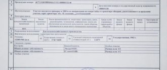
- Creating a plan map. This is the main document of a cadastral specialist; it has two parts - graphic and text. The first half presents a detailed drawing of the cadastral quarter indicating boundaries, buildings, communications, etc. The second half contains all legal acts on property, as well as a verbal description of measurement and assessment activities. Here you can find information about the location of the territory in the city, the presence of entrances, road junctions, infrastructure, etc.
- Receiving a work acceptance certificate.
The final result is a detailed map plan; this document is necessary to achieve urban planning goals.
What has changed under 150-FZ dated June 17, 2019
In 2021, the procedure for carrying out complex cadastral work was revised and adopted in Law No. 150-FZ dated June 17, 2019, which came into force in September 2021. What has changed? From September 16, 150-FZ amends two federal laws: 221-FZ (on the cadastre) and 218-FZ (on the registration of real estate), thereby simplifying the procedure for carrying out complex cadastral work in terms of providing documents. There are also other changes. Let's briefly go through the main changes:
- it became possible to carry out complex cadastral work without a territory surveying project;
- it is allowed to use previously prepared documentation from the BTI archives (copies of situational plans of land plots, planning and cartographic materials, etc.);
- the copyright holder, who should not interfere with complex cadastral work, now has the right to demand the presentation of documents from the cadastral engineer confirming the work;
- the deadlines for cadastral registration in Rosreestr have changed (increased from 5 to 15 working days);
- if, when clarifying the boundaries, it is revealed that the area of the area being adjusted is reduced by more than 10 percent (compared to the information that is already available in the Unified State Register), then the written consent of the owner is required. (No consent - cadastral registration is suspended);
- Cadastral registration is also suspended if, when clarifying the boundaries, the area of the plot turns out to be more than 10% greater than the area of information contained in the Unified State Register of Real Estate.
From the last two changes we can conclude that if today the information in the Unified State Register about the area of your land plot does not coincide with the actual measurements that the cadastral engineer will make during complex cadastral work, and these discrepancies will be within 10% of the area indicated in the Unified State Register – then your site will acquire new coordinates (it can become either larger or smaller). But an increase or decrease is only possible by 10 percent. If the land area goes beyond this ten percent limit, then cadastral registration is suspended for this reason until the situation is corrected. For more information on how you can increase your plot, read the articles: “Land addition in 2021” and “Redistribution of land plots.” These are, in fact, all the main changes around which there is so much noise. In fact, citizens had the opportunity to increase the land plot by up to 10 percent when carrying out cadastral work on an individual basis before.
How to choose a company for engineering surveys in the field of cadastre
An authorized person should listen to our recommendations:
- You need to ask about the equipment used. These are metric instruments, computer programs, and the possibility of satellite imaging.
- View the portfolio - what projects have already been developed, whether you have experience working with municipal orders.
- Quality is expensive, the service is not free, although it is provided to the state.
- You need to familiarize yourself with the issued activity license.
Financing of the construction work comes from the state budget by allocating subsidies to a constituent entity of the Russian Federation, so the contractor can receive the final amount only after providing a detailed map plan and an act of acceptance of work.