Geodesy on a land (garden) plot is necessary, first of all, to check (establish) the exact boundaries of the plot in order to avoid further disputes with neighbors.
Topography of an area up to 20 acres
Price from: 12,000 rub.
The price is valid until June 4
Call me back Calculate cost
The first mention of geodesy, for establishing the boundaries of land, can be found in Ancient Rome. The patron of the first surveyors was Term - the god of borders, his symbol was a stone that served as a mark.
Today, the purpose of geodesy has expanded significantly, but the basic principles remain - measuring distances and angles, followed by the necessary calculations. The need to measure land plots remains unchanged, especially in matters of establishing boundaries.
What is geodetic work
The science that studies our planet, the earth's crust and its properties, methods and methods for measuring the Earth's surface is called geodesy. She is busy marking the ground.
After the first person went out for a walk and couldn't find his way back to his home, people needed maps of the area so they could draw a plan to return.
And in order to get a map of the area, the land on which it is located, as well as all objects, buildings and structures, it was necessary to measure. And not just measure, but tie objects to each other, correlate them with the area where they are located, and draw a map of a specific area. The first section was followed by the second, third and so on.
Geodesy is usually divided into several areas:
- higher geodesy (the idea of the Earth as a planet);
- topography (description of the area);
- cartography (creation of plans, atlases and maps);
- the engineering geodesy;
- applied geodesy (geological and environmental work).
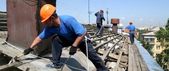
To build some kind of capital structure, it is also necessary to carry out work to mark the territory. Compare characteristics, indicate coordinates, put them on a plan - all this requires geodetic work. All work related to the earth's crust is called geodetic surveys.
Geodetic work includes:
- marking areas;
- laying out the foundation for construction;
- control over the parameters of structures;
- drawing up plans and maps;
- control over deformation of constructed buildings.
When carrying out geodetic work on large objects or undeveloped territories, a system of special knowledge is required, which is available only to professionals. It is not advisable to cut the budget and save here - it will cost you more.
The unspoken truth
A ruble spent on geodetic work will save 10 rubles on design, 100 rubles on construction and 1000 rubles on operation.
Geodetic surveys are carried out throughout the entire complex of construction work, and their results serve as standards and rules that guide construction companies.
Where and on what principle does it work?
For a long time in Russia there was a state monopoly on geodetic work, and all the necessary research was carried out by specialists from exclusively state-owned organizations and enterprises. Almost all the data received was classified by the military.
Now there is also a Federal Agency for Geodesy and Cartography, which is in charge of many issues in this area. This is a huge organization with regional divisions and a number of state-owned enterprises. It deals with a very wide range of tasks: from maintaining the state geodetic network in working order to space photography and designing air defense systems. But, as elsewhere in the public sector, a surveyor specialist here cannot count on a large salary.
Despite the state infrastructure and the reluctance of the military to disclose cartographic data, the market for geodetic services from private companies in Russia has nevertheless formed and the number of licenses for companies engaged in geodetic surveys already numbers in the thousands. Indeed, in the last decade, not only the needs for such work, in particular in the construction sector, but also the requirements for their technical support have increased significantly. It is not surprising that private companies turned out to be more flexible and keep up with the times in this regard than a large government agency, where the main incentive to work is not to fall under the hot hand of the boss..
As in most professions, the most interesting area in geodesy is, of course, scientific geodesy. But, unfortunately, in our country specialists most often have to choose between an interesting but low-paying job at a research institute and high salaries for monotonous work in private organizations.
So, geodetic engineers work at state-owned enterprises, in the military sphere (military topography, alignment of launch complexes and artillery), in numerous private companies, and on their own as individual entrepreneurs. In the latter case, they can engage in small objects and cadastral activities (if they have a certificate).
What about your work routine?
The work schedule of a surveyor is very different from the usual work routine.
- Of course, many people work 5 working days and rest for 2 days. They work for a salary and possible bonuses for overtime, etc. Most often this happens at state-owned enterprises, for example at Mosgorgeotrest and the like.
- There is a shift method. That is, the surveyor spends time on business trips from 2 to 6 weeks. And he works there every day. Usually they work on a rotational basis in remote parts of our homeland when laying gas, oil pipes, etc.
- There is an option to work according to actual workload. That is, this is work on a contract basis. If there is work, it works, if there is no work, you can rest.
- In general, depending on the nature of the surveyor’s workload, the choice is very large.
What are the types of geodetic work - 5 main types
In addition to associated geodetic work, pre-construction surveys are also carried out. These are fundamental operations with the earth, thanks to which the foundation of the future structure is laid.
Simultaneously with the construction of buildings, control measurements and observations of soil deformation are carried out, which also requires geodetic control of earthen areas.
Type 1. Topographic and geodetic works
The implementation of cartographic schemes predetermines the entire further part of the production project. The area is surveyed in one of the approved scales.
Calculations for topographic work on a large scale are made for certain construction sites, for multi-storey buildings, for the reconstruction of engineering structures, for landscaping city blocks, etc.
Small scales are used to create plans:
- settlements;
- mining enterprises;
- transport hubs;
- industrial facilities;
- and other large structures.
Read special material on this topic in the article “Topographic Plan”.
Type 2. Marking work
Designed to create the basis of geodetic signs linked to the state geodetic network. Such signs are placed and maintained throughout the construction period, ensuring field quality control of the development.
It also involves the creation of alignment drawings, linking to the existing network and staking out the main axes of the structure.
Situation is not painting, but transferring and fixing key points of the project on the ground.
The results of the work are transferred to the contractor, accompanied by an explanatory note, a diagram of the initial coordinates, a drawing of the fixed geodetic signs and their corresponding markings.
Type 3. Executive geodetic survey
This type of work is carried out throughout construction. Surveying controls the structures being erected and their location according to the project. This work provides a clear picture of the compliance of completed and planned production. Particular attention is paid to parts of buildings that are responsible for the stability and compliance of the entire structure with previous alignment work.
Permissible deviations from the norms of construction and design documentation and compliance with GOST requirements are also measured.
Based on the results of the as-built survey, an act of acceptance and transfer of construction and installation works is formed.
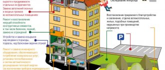
Type 4. Monitoring of deformability and displacement of erected structures
Monitoring of distortion of structures is carried out throughout construction and even after its completion.
Monitoring is usually divided into several stages: initial (during the construction of the foundation), above zero (or every 5 floors), final (upon completion of construction), warranty and operational (determined by the materials and purpose of the object).
Measurement highlights:
- roll and deflection of the foundation;
- settlement of the structure;
- roll of structures;
- deviation from the monolith of parts of the structure.
Monitoring of deformation is carried out in two aspects: monitoring the influence of the structure under construction on existing buildings and the influence of these buildings on the structure under construction. This is why topographic surveys are carried out.
View 5. Control survey of underground networks
It is almost impossible to guarantee how the building will sag after construction is completed. There are too many unpredictable influence factors - from human to natural. This is why continuous measurements of underground networks are carried out.
Surveying of underground networks is carried out for the final recording of all communications, wells, sewers, drainage, as well as their properties (diameter, slope, depth) after they are hidden from the human eye.
An important point for underground surveying is the intersection and connection with other utility networks. All points linked to the geodetic network are included in the control diagram in order to carry out repairs and build additional structures in the future without causing damage to hidden communications.
Based on the completed geodetic work, a situational plan is drawn up.
What problems does geodesy solve - 4 main tasks
With the help of geodetic science, humanity is trying to study and use its home planet. Geodesy as a practical science helps people navigate their habitat, improve and modify the surrounding area.
But the main application of geodesy is the construction of buildings and other structures.
Task 1. Selecting a suitable location for the object
It is thanks to geodesy that the location of the construction site is chosen. Factors of the structure of the earth's thickness are taken into account. The area is being explored and geological surveys are being carried out.
A plan diagram of the occurrence of rocks is drawn up, based on which the composition of the foundation to be laid is determined. Or the surveyors' recommendations will be made in favor of moving the construction site, or even completely canceling the plan.
Main criteria for placing construction sites:
- composition and characteristics of rock layers;
- terrain;
- surrounding areas.
Task 2. Competently linking the building under construction to existing ones
Since construction has become a human passion for quite a long time, and gigantic areas of the Earth have been built up, it would seem impossible to imagine a disorderly accumulation of houses in places where people live.
How possible! That is why megacities are constantly being built, rebuilt and completed. They grow up and down and spread across the surface of the planet like mold on wood. And if it weren’t for geodetic design, I’m afraid the human anthill would have collapsed like a house of cards.
And from the point of view of comfort, it is more convenient for people to locate their structures depending on existing buildings.
Example
At first, Academician Kurchatov did not begin to lay paths around the institute under his jurisdiction. Having waited for the moment when the employees themselves would trample the paths they needed, he ordered them to be asphalted.
Task 3. Representation of areas on topographic maps
Using topography, you will receive a detailed plan of the building area. It will display all objects located on the ground, their connections and utilities.
The diagram will also display the terrain.
The topographic map is compiled in three stages:
- Field work (on-site measurements).
- Office work (bringing calculations together).
- Drawing up a plan (drawing a map in accordance with the data received).
Using topography, it is easy to restore the boundaries of a site on the ground.
Task 4. Study of large-scale displacements of the earth's crust
This is the task of higher geodesy. It is thanks to such work that earthquake-resistant areas and areas susceptible to surface distortion are determined. The dependence of shifts of the earth's crust platforms on satellites, planets and other cosmic bodies of the solar system is revealed.
The ebb and flow of tides, active uplifts and stable depressions of areas of the Earth's surface are all important basic principles of global geodesy. These factors influence the planet's climate, and they are studied through environmental research.
Who needs to study
It must be carried out by everyone who wants to build something or perform other actions on a certain plot of land. By contacting a surveyor, you will receive a clear indication of the boundaries of your land plot and its detailed plan, using special surveying. The plan will be drawn up in detail, indicating the features of the relief.
Without this plan, it is impossible to draw up an architectural project and begin construction of the facility. Design, arrangement of communications and construction will be carried out on the basis of a geodetic plan.
The procedure for carrying out geodetic work - 6 main stages
During any construction, geodetic research is in demand. Whether it is one house or an entire block, or even a city, a street, an industrial complex - everywhere the initial intervention of specialists is necessary.
When creating projects, engineers rely on the terrain, dependence on the surrounding infrastructure and soil structure.
The entire complex of geodetic works is designed to locate construction projects in accordance with the approved plan. That is why surveyors work on constructed structures until they are put into operation.
Stage 1. Selecting a company to carry out geodetic work
Pay attention to the company's experience. The longer a company offers its services, the more accumulated knowledge and skills in marking territories.
Reputable enterprises have a package of services provided during the construction of a particular structure.
Note what equipment and tools the company’s specialists use. Modern surveyors use digital, photographic and laser technologies to determine land markings.
Stage 2. Conclusion of a contract and approval of technical specifications
When approving the project, consult with the architect. He will give practical advice regarding the data that will be needed for further work. Consider and sketch out a drawing of the proposed construction together - this will simplify the development of technical requirements for surveyors.
Depending on the relief, area and location of the site, geodetic survey takes no more than one day of work. For large objects, the stages of work are determined based on the specific requests of the client.
An agreement with an engineering and geodetic company is concluded either for a specific period with clearly defined tasks, or includes a list of works that must be performed at a certain stage of construction.
At the end of the contract, the contracting company provides the customer with documentation with fixed boundary marks, reference to the state geodetic network and fixed boundaries of the site.
Stage 3. Collection and analysis of information about the site
At this stage, there is a general assessment of the upcoming surveys with a visit to the work site. Data is collected on the location of the site, surrounding areas and terrain. Additionally, the access of the drilling rig to the work site is determined.
The analyst also selects the tools and equipment to be used. Depending on the territory, measurement errors are also allowed. Each tool has its own permissible deviation standards.
Let's look at the table of errors when measuring a site:
| № | Area, km² | Exceeding error, mm | Angle error, s |
| 1 | up to 1 | 1-5 | 30 |
| 2 | from 1 to 5 | 5-10 | 30 |
| 3 | from 5 to 10 | 5-10 | 30 |
| 4 | over 10 | 10-15 | 30 |
Almost all modern geodetic instruments have the ability to measure angles, distances and surface slope.
Stage 4. Construction design
This is a series of topographic works to link the site to the existing geodetic network. Studying the natural conditions for the placement of project objects, collecting additional information, creating a geodetic basis for construction.
In practice this means:
- building a work plan;
- topographic survey;
- transfer of reference points to the terrain.
This is the beginning of direct work on the territory. Installation of boundary points, based on which, specialists will mark for pouring the foundation. All geodetic signs installed on the construction site are kept intact until the construction is completed.
Stage 5. Centering stage
So, we have secured key points in the territory. Now, based on them, we can transfer the entire project to the land plot. When laying out, specialists use the same tools as for topographic surveying, namely: levels, theodolites, tacheometers.
Carrying out the project in situ, that is, directly on the land plot, also includes marking out utility lines.
Simultaneously with the breakdown of the main structures, the following occurs:
- sewerage and water supply connections;
- heating system supply;
- installation of electrical networks;
- design of drainage and ventilation systems (if they are not included in the construction project of the main complex).
As the axes of the main and intermediate structural elements are marked, reporting documentation is being developed and prepared. An operational log of geodetic work is compiled.
It states:
- time of work;
- what tools were used;
- performers;
- executable tasks;
- compiled documentation.
Stage 6. Drawing up a report on completed geodetic work
Based on the results of the work performed, a master plan of the facility is drawn up. Interim or current auxiliary drawings accompany all stages of construction. They are included in the final plan as additional documents and attached as an explanatory note.
All engineering and construction work is accompanied by geodetic surveying. These adjustments by surveyors help correct mistakes in a timely manner and control deviations from building codes.
Why is geodetic soil research carried out?
They are essential for determining the gravitational field and shapes of the earth. It must be carried out carefully, with particular precision, since its results influence the construction of the future facility. Even a small deviation can lead to irreparable consequences. For example, to distortion of the structure of a building.
Geodetic research is carried out before the start of drawing up a project for a future building and accompanies it at all stages of construction. The success and quality of the future project will depend on how accurately the geodetic study is carried out. All features of the land plot on which construction will be carried out must be taken into account.
Where to order high-quality geodetic services - review of the TOP 3 geodetic companies
With the development of geodesy and the increasing demand for land surveys, the growth of companies providing surveying services is expanding.
We have compiled a review of the 3 most reliable geodetic organizations in the Russian Federation.
1) Earth-Pro
The company provides services for a variety of geodetic works. The organization’s employees are ready to carry out the necessary research as soon as possible and draw up a package of documents characterizing your land plot.
The company's surveyors are ready to take on the most non-standard tasks and provide a guarantee for all work done.
If you are ready to become a client of the company, then you will be given several cooperation options to choose from. After comparing the conditions and prices, you will choose a program that attracts you; they will tell you what other documents are needed to formalize construction, and correct technical errors in existing land plans.
2) Nakor-K
The company operates throughout Russia. Founded in 2000, the company takes a responsible and high-quality approach to performing various types of tasks within the profile of its industry.
Types of activities practiced:
- engineering and geodetic surveys;
- geodetic support of construction;
- control over the deformation of structures during the construction of structures;
- other research.
Nakor-K is an established team of professionals that offers a wide range of services, comprehensive studies and unique solutions in the field of geodesy.
3) Geodetic
A young, ambitious company focuses its activities on performing a range of geodetic surveys in construction and industry. The company's experts are graduates of leading Russian higher educational institutions. Highly qualified specialists work both throughout Russia and abroad.
The company's competitive advantages lie in the use of modern technologies, high-precision instruments and the development of new data processing methods. The results of the work are provided to clients both in classic paper form and in electronic form.
How to save money on geodetic work - 3 simple tips
Despite the fact that geodetic surveys require special knowledge and tools, it is quite possible to pay less for this work than professionals ask for.
You will have to refresh some aspects of your knowledge of the earth and master unfamiliar tools. But laying the foundation for a future structure yourself will be very tempting and honorable.
You don't measure the ground with white gloves. You'll have to get dirty.
But then you can proudly say that it was you who laid the foundation for the building!
Tip 1. Carry out geodetic work yourself
Basic procedures for a plot of land marked for construction are not at all difficult to carry out.
You can independently determine:
- depth of the sand layer;
- the size of the fertile layer;
- soil composition;
- depth of aquifers.
Dig a couple of pits (simple holes) with straight walls. Or use a hand or electric earth auger. The layers of the earth will be clearly visible and can be easily measured with a regular tape measure.
This knowledge will help you in preparing the foundation of a future structure.
Tip 2. Use ready-made topographic maps of the area
Do you want to erect or rebuild a building in a country house or any other private building site? When surveying land plots, topographic plans must be drawn up.
They are kept by the chairman of the dacha association or the chairman of the development cooperative. Use them - no one has the right to refuse you this!
Maps of the area on a large scale will help determine the most favorable location of the building in relation to external communications, the elevation and slope of your site, and orientation along the sides of the horizon.
Tip 3. Involve neighbors in calling specialists to the site
The demand for the services of surveyors today is obvious. Each visit of specialists to the field accounts for up to 20% of the cost of services. Surely, you have neighbors in the area who also need to carry out work to measure the land. Why not call the brigade together? Moreover, measurements on one site take several hours.
In one day, surveyors will carry out work in several areas, depending on the complexity of the terrain and the area of the territory. This will significantly reduce the cost of creating the circuit you need.
Watch an educational video about geodesy.