Cadastral Chamber: who carries out accounting
It is logical that the unified land cadastre of Russia needs administration and management. These functions are intended to be performed by the Federal Cadastral Chamber (FKP), a structural division of Rosreestr, which is entrusted with a number of main functions of the service:
- maintaining the state real estate register (EGRN);
- carrying out state registration of real estate objects and transactions with it;
- cadastral registration and approval of cadastral valuation;
- provision of current information from the Unified State Register of Real Estate;
- accepting applications from citizens and organizations for cadastral registration and registration;
- determination of cadastral value.
FKP interacts with cadastral engineers, providing them with practical and methodological assistance.
Currently, the chamber has 81 branches and operates both in individual regions of the Russian Federation and on an interregional basis.
An important task assigned to the chamber is to ensure the operation of information systems and interaction schemes with other government bodies.
Read more about the FKP in the publication “Cadastral Chamber”.
Cadastre object
Land is a direct object of the cadastre as a natural resource, as a component of market relations, as a means of agricultural or industrial activity. As an agro-industrial resource, it is characterized by fertility (soil properties, moisture content, types of vegetation). As an object of labor, it implies parameters for the use of technologies for planting, harvesting, and the possibilities of mechanizing agricultural activities, taking into account the availability of water resources.
General information about the USRN
The main source of cadastral information, administered by the FKP, is the real estate register. The Unified State Register contains information about all immovable objects existing in the Russian Federation:
- buildings;
- unfinished construction sites;
- land plots.
As Art. 7 (hereinafter referred to as Federal Law No. 218), the register is a collection of current information from the following databases:
- real estate cadastre;
- register of rights and restrictions on them;
- cadastral maps;
- register of boundaries of specially protected zones.
Its main role is to record the results of cadastral registration, the emergence and transfer of rights to objects.
Registration in the Unified State Register of Real Estate is the only thing that can confirm the existence of land ownership. Such registration is confirmed by an extract that replaces previously issued certificates of state registration of rights to real estate.
Information in the Unified State Register of Real Estate is open and accessible to any citizen. You can even get them online using other electronic resources.
More information about the Unified State Register of Real Estate in the publication “Unified State Register of Real Estate”.
Goals and objectives
The purpose of this body of information is to provide information for several areas of government activity. These areas constitute the tasks of the land cadastre.
These include:
- land management;
- ensuring that lands are used and protected properly;
- activities that are designed to preserve and increase soil fertility;
- state registration of rights to real estate and transactions with it;
- land management;
- valuation of land from an economic point of view and taking into account the value of land along with other natural resources;
- establishing an objective payment for land, the amount of which is officially confirmed.
Features of cadastral registration in Russia
Over the past decade, Russia has been actively developing a unified cadastral registration system, in which:
- all existing information systems are integrated;
- all data on real estate objects are combined;
- registration procedures have been unified.
This process takes place under the supervision of Rosreestr, within which all cadastral authorities of the Russian Federation are united.
The result of this work was the creation of the Unified State Register of Real Estate and the formation of a publicly accessible public cadastral map, which many perceive as the official website of the land cadastre.
These electronic services combine cadastral information about real estate, regardless of its type.
Cadastral registration is unified, that is, it is carried out in the same way for any object, including land plots.
Read about the features of land registration in the article “Cadastral registration of land plots”.
In recent years, the very concept of land cadastre has undergone significant changes, which are worth discussing in more detail.
Objects and subjects
The objects of state cadastral registration of land plots are territories belonging to both individuals and legal entities. If the plot is not registered in the Unified State Register of Real Estate, no transaction can be carried out with it.
The following may act as subjects of cadastral registration:
- state body carrying out the accounting procedure;
- the copyright holder or his legal representative;
- cadastral engineer.
When allocating a new land plot, it should be immediately registered in the cadastral register. The presence of data on the allotment in the Unified State Register is the only evidence of its existence.
How to find out if a land plot is registered in the Unified State Register of Real Estate?
The cadastral number of the land can be found in the cadastral passport (issued until 2021) or in the certificate of registration of property rights. In addition, you can order an extract from the Unified State Register of Real Estate or use the public cadastral map posted on the Rosreestr website (what a cadastral passport and an extract from the Unified State Register of Real Estate are and what information is displayed there can be found in a separate publication). If a plot is on the map, then it is registered in the cadastral register. You can click on it and view the data entered in the registry.
General information about the land cadastre
The reform of the cadastral registration system also affected the state land cadastre (GLC). As a result of the unification of state accounting systems, it was transformed into the state real estate cadastre (GKN), although its essence and principles of creation have not changed much.
According to previous standards, the land cadastre is an information system containing information obtained as a result of cadastral registration of land plots:
- location;
- appointment;
- registered types of rights;
- territorial zones in which they are located;
- other data that allows you to individualize a specific area.
However, since 2008, this system was abolished due to the formation of the state real estate cadastre. Today it is difficult to explain what a land cadastre is, because it does not exist.
The real estate cadastre that replaced it is an identical database, but containing information about all objects, not just land. And the amount of information in the current system is much wider than in the land cadastre.
In accordance with Art. 8 Federal Law No. 218, in its current form, the state land cadastre contains information about:
- type of object, its cadastral number and description of location;
- area and other basic characteristics;
- cadastral engineer who carried out the registration;
- construction projects erected on its territory and their numbers;
- cadastral quarter and cadastral value;
- categories of land, types of use and natural objects located within the site;
- assigning a site to special categories;
- results of land supervision;
- encumbrances and restrictions on use;
- history of formation and land surveying of the site, and so on.
Thus, despite the different terms and the transformation of the GZK into the GKN, the authorized services managed to preserve the essence of the information system. It still systematizes data on real estate, but now the range of cadastral registration objects goes far beyond land plots.
Legal basis of the state land cadastre
The State Land Cadastre is a systematized collection of documentary information about objects of state cadastral registration, about the legal regime of land in the Russian Federation, about the cadastral value, location, size of land plots and real estate objects firmly associated with them. Land plots and other real estate objects firmly associated with them are recognized as objects of state cadastral registration. The state land cadastre also includes information about the subjects of rights to land plots.
The procedure for maintaining the state land cadastre is established by the Federal Law of January 2, 2000 “On the State Land Cadastre” and other regulatory legal acts. State cadastral registration of land plots, carried out in the prescribed manner before the Federal Law “On the State Land Cadastre” came into force, is legally valid. Bodies carrying out state registration of rights to real estate and transactions with it, bodies (organizations) carrying out special registration or accounting of certain types of real estate, natural resources and territorial zones, provide free information within ten days about registered rights and the availability of real estate objects , firmly associated with land plots, and territorial zones to the bodies carrying out activities for maintaining the state land cadastre, to the required extent.
The powers to maintain the state land cadastre are distributed between the Russian Federation, its constituent entities and local governments. State authorities of the Russian Federation develop, adopt federal laws and other legal acts in this area, their compliance,
develop, approve and implement federal programs for the development of the state land cadastre, determine the federal executive body authorized to carry out activities related to maintaining the state land cadastre, approve lists of basic information of the state land cadastre, establish the limits and procedure for using the fee charged for providing information from the state land cadastre , determine lists of limited access state land cadastre information.
Subjects of the Federation have the right to independently establish a list of additional information from the state land cadastre not established by the Russian Federation. The collection, processing and storage of this information is carried out at the expense of the constituent entities of the Federation.
Local government bodies may be vested by law with certain state powers in the field of carrying out activities related to maintaining the state land cadastre with the transfer of the material and financial resources necessary for their implementation. Inclusion in the state land cadastre of additional information not established by the Russian Federation and its constituent entities is carried out by local government bodies independently and at the expense of local budgets.
Information from the state land cadastre is a state information resource and is open in nature, with the exception of information classified as restricted access. Bodies carrying out activities for maintaining the state land cadastre are obliged to provide information from the state land cadastre to the interested individual who has presented an identity card and a written application, and to a legal entity with the presentation of documents confirming the state registration of the legal entity and the powers of its representative. Information provided legally from the state land cadastre to citizens and legal entities can be used by them to create derivative information for the purpose of its commercial distribution with the obligatory indication of the source of information. The procedure for providing this information is determined by the Government of the Russian Federation. Currently, the Rules for the provision of information from the state land cadastre are in force, approved by Decree of the Government of the Russian Federation of December 2, 2000 No. 918.
State management of activities related to maintaining the state land cadastre is carried out by the Government of the Russian Federation directly or through an authorized federal body. Currently, such a body is the Federal Land Cadastre Service (Roszemkadastr). It operates in accordance with the Regulations on the Federal Land Cadastre Service of Russia, approved by Decree of the Government of the Russian Federation of January 11, 2001 No. 22.
Principles of cadastre maintenance
The legislator allows us to identify 4 main principles underlying the conduct of the State Tax Committee:
- The principle of unity of systems used and cadastre maintenance throughout Russia.
- The principle of continuity in maintaining the cadastre and making changes to it to ensure up-to-date data.
- The principle of openness of information of the State Committee for Human Rights: public availability of information.
- The principle of compatibility of real estate cadastre information with other information systems: the formation of a single USRN.
It can be argued that the state land cadastre is maintained in order to systematize the work on management, protection and registration of land rights, land use activities, land management, ownership and disposal of land.
Information from the cadastre can be used not only by government officials, but also by any other person, because information about real estate is in the public domain.
If we consider cadastral business as a scientific discipline, we can highlight the subject and methods of land cadastre. The subject of the cadastre can be considered the patterns used in the creation and maintenance of the State Property Register as a unified information base that provides citizens with up-to-date data on real estate.
The cadastre activities use methods of mathematical modeling and economic assessment. This allows the GKN to research, study and process incoming information, as well as systematize it to complete the main task.
Maintaining the state land cadastre
Throughout the Russian Federation, the state land cadastre is maintained according to a unified methodology and represents sequential actions to collect, document, accumulate, process, record and store information about land plots. Information about the condition and use of land plots, their areas, location, economic and qualitative characteristics is entered into the documents of the state land cadastre on the basis of data on the surveying of land plots, information provided by the legal holders of land plots, the results of topographical, geodetic, cartographic, monitoring, land management, soil, geological-geomorphological and other surveys and surveys. The list of information about land plots is applied taking into account each category of land.
Information on rights to a land plot and restrictions (encumbrances) of these rights is entered into the Unified State Register of Lands on the basis of information from the Unified State Register of Rights to Real Estate and Transactions with It, as well as on the basis of other documents on rights to land plots. legally valid at the time of entering the specified information into the state land cadastre.
Information on the economic characteristics of land plots is entered into the documents of the state land cadastre on the basis of data from the state cadastral and other assessment of land and the provisions of regulatory legal acts of state authorities and local governments.
Information about territorial zones is entered into the documents of the state land cadastre on the basis of data received from the authorities that register or record territorial zones.
Documentation of information from the state land cadastre is carried out on paper and (or) electronic media. If there is a discrepancy in information recorded on paper and information recorded on electronic media, information recorded on paper takes priority, unless otherwise provided by federal law.
Correction of technical errors made in the maintenance of the state land cadastre is carried out if there is no reason to believe that such correction may cause damage or violate the legitimate interests of land owners or third parties who relied on the corresponding records in the state land cadastre. If the above-mentioned concerns exist, then such correction is carried out on the basis of a court decision or arbitration court. Information about the correction of technical errors or about the refusal to correct technical errors within five days is sent in writing to the rights holders of land plots or third parties who relied on the corresponding records in the state land cadastre.
The Unified State Register of Lands and cadastral files are subject to eternal storage; their destruction and seizure are not allowed. The procedure for storing other documents of the state land cadastre, except for those mentioned, is established by the Government of the Russian Federation. Basic documents of the state land cadastre are subject to insurance in the prescribed manner.
Tasks of the GKN
Taking into account the principles of management and the purpose of creation, you can understand why a land cadastre is needed. Its main task is to ensure the availability of information about specific areas, as well as systematize cadastral registration data.
With its help, not only a database of real estate is formed, but also open access to it is provided to interested parties:
- government bodies;
- cadastral engineers;
- organizations or individuals engaged in real estate transactions.
The deeper task of the State Property Committee is to ensure correct activities in zoning, cadastral registration, land surveying, registration, land assessment and other professional activities.
The listed tasks, perhaps, are of interest only to a graduate of the specialty “land cadastre and land management”; they, as a rule, do not concern ordinary people.
Tasks
Maintaining the land cadastre is carried out for the purposes of:
- Supervision over the protection and operation of territories.
- Recognition of the existence of plots, their association or division.
- Land zoning.
- Soil fertility assessments.
- Accounting for real estate related to land plots.
- Carrying out cadastral surveys.
- Assessments of territories to establish reasonable fees for their use.
- Protection of the rights of land owners.
- Obtaining information on the civil circulation of plots.
- Registration of rights to land and legalization of transactions with them.
The main task of cadastral registration is to provide all interested parties with reliable information about the location of lands and their main characteristics.
Legislation on cadastral activities
Until 2021, cadastral activities were carried out in accordance with. He also put into operation the state real estate cadastre, its contents, rules and conditions of maintenance.
Since 01/01/17, cadastral registration activities are regulated exclusively by Federal Law No. 218. This law:
- regulates the grounds for accounting;
- determines responsible officials;
- establishes the timing of accounting;
- determines the package of necessary documents and other features depending on the type of real estate.
Objects of cadastral activities
According to the previously existing rules of cadastral activities, the division of cadastre information systems was carried out not only by type of real estate, but also by territory.
Previously, there was a city cadastre, which included objects within a settlement, as well as a regional and state cadastre.
After the integration of information systems into a single database, city databases were eliminated, and this concept should mean the city division of Rosreestr.
After combining information systems, in accordance with paragraphs. 4 paragraphs 1 art. 8 Federal Law No. 218, the public cadastre of land plots and other real estate is maintained in relation to:
- land plots for agricultural, forestry, dacha and gardening and other purposes, plots for housing development;
- buildings and structures, regardless of their intended purpose, unfinished construction projects;
- premises in buildings, single property complexes, including enterprises;
- parking spaces and other types of real estate.
Cadastral documentation
Despite the introduction of electronic systems, cadastral registration is accompanied by the preparation of many documents. All land cadastral documentation is divided into textual and plan-cartographic.
Text documentation usually reflects the current legal status of accounting objects and is compiled on the basis of cartographic information, which includes:
- cadastral plans and cadastral map;
- land ownership maps and diagrams;
- soil map;
- map of lands with encumbrances;
- assessment cartogram;
- explication of lands or contour sheet;
- land balance of the region and so on.
The compilation and use of these documents is the task of the accounting authorities; they do not have much significance for citizens.
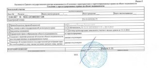
After cadastral registration or registration of land rights, the owner receives only a cadastral passport for the plot with its plan, a boundary plan and an extract from the Unified State Register of Property Rights.
Read more about the extract in the material “Cadastral extract of a land plot.”
Stages of cadastral registration
In order to register a land plot for cadastral registration, the following actions are performed:
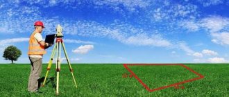
- The owner of the plot enters into an agreement with a cadastral engineer to carry out surveying and cadastral work.
- The cadastral engineer collects all available information on the land plot. Examines title documents, extracts from Rosreestr, cadastral plan of the territory, information about the title holders of neighboring land plots.
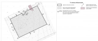
- Surveyors go to the area. They take photographs of the coordinates of turning points to describe the boundaries of the land plot. All significant objects are mapped on the territory: fences, poles, real estate located on the site. After surveying, surveyors secure the turning points registered in the cadastral register with boundary signs.
- The position of the boundaries of the land plot is agreed upon with the owners of adjacent plots. If neighbors disagree with the established boundaries, an entry is made in the agreement document. The case is resolved in court. If the neighbors are properly notified of the land survey, but there is neither a signature of consent nor a written refusal from them, the boundary is considered agreed upon. In this case, it is necessary to attach to the boundary plan the grounds confirming the notification of neighbors about the work being carried out.
- Information about the site from the State Property Committee, owner documents, geodetic data is brought together and a boundary plan of the site is drawn up.
- The boundary plan, agreed upon in the prescribed manner with adjacent land users and certified by a cadastral engineer, is received by the customer. The boundary plan includes a set of information that will be required to register the site with the cadastral register.
- The owner or his representative submits to Rosreestr an application for cadastral registration of the plot, title documents, and a boundary plan. If it is impossible to submit documents in person, you can contact the multifunctional center or send documents by mail.
- Information about the land plot is entered into the State Property Committee. The land plot is assigned a cadastral number.
- After the plot is registered, the applicant is issued a cadastral passport for the plot.
Carrying out cadastral registration and land surveying ensure maximum compliance of documentary information with the situation on the ground and allow establishing order within the boundaries of the plots.
Author of the article
Cadastral map of lands of the Russian Federation
Perhaps the simplest and most publicly accessible electronic system compiled on the basis of GKN data is (PKK). This information resource of Rosreestr is intended for viewing current information contained in the state real estate cadastre.
The PKK is an interactive topographic map divided into cadastral districts, districts, blocks and specific plots - the smallest units of division of the territory belonging to the owners.
To obtain up-to-date information from the State Property Committee, just find the desired area on the public map and click on it with the mouse, after which the system will provide up-to-date information about:
- type of property and its cadastral number;
- categories of land and form of ownership;
- cadastral value and address assigned to the site;
- area of the site and types of permitted use;
- date of registration, changes, their publication and other relevant information about the object.
In the “Services” tab, you can request official information, in particular, submit a request to Rosreestr to receive information from the Unified State Register and State Property Committee on an official form.
On the map itself there are special tools with which you can filter information, change the map view, measure distance, or print information.
Cadastre development
For the development of the state land cadastre, cadastral registration of land plots, i.e. description and individualization in the United State Register of Lands of land plots; therefore, each land plot receives special features for its quality assessment, and an economic assessment is performed.
The state cadastral valuation of land territories was carried out to determine the cadastral value of sites for various purposes. During the state cadastral assessment of land, an assessment zoning of the territory was carried out. The assessment zone is part of the universal form of land in the purpose, type of functional use and land plots close to the cadastral value. As a result of the assessment zoning, a map (diagram) of assessment zones was drawn up, and the cadastral value of a unit of area within the boundaries of these zones was established.
Methodological, regulatory and technical documents necessary to carry out state cadastral valuation.
The cadastral valuation of land is the basis for taxation, just as it is a data bank in cartographic and semantic display, created as a system of information about the territory, material elements, population, infrastructures, etc.
The basis of the land cadastre is compiled with the following details:
- land (with accurate assessment of areas and measures of land use objects);
- ecological-geographical, containing a combined system of features of environmental components;
- economic, providing information about the features of planning, accounting, profitability of land use, cost;
- legal – legal aspects of land use regulation based on the Land Code.
What is a cadastral error
The GKN must contain up-to-date information about accounting objects. The discrepancy between the information and the actual state of affairs (the area, address, type of use, cost, etc. does not match) is considered a cadastral error.
The inaccuracy may arise as a result of an oversight by the cadastral engineer, local authorities preparing the location documents, or a technical error made by an employee of the cadastral registration authority, for example, a typo.
The procedure for correcting an error depends on its nature. Such powers are vested exclusively in Rosreestr. If an inaccuracy is detected, he is obliged to notify the owner of the property about the need to make corrections to the original cadastral documents.
Read more about the procedure in the material “Cadastral error”.
Land supervision
Land supervision is the activity of officials to identify and prevent violations of land legislation. This function is assigned to Rosreestr employees.
During the service, a special profession was created and the position of state inspector for the use and protection of lands was established. He checks the activities of land owners and owners for:
- compliance with the intended purpose of land and use in accordance with permitted activities;
- compliance with the requirements for mandatory use of sites;
- unauthorized use of land plots;
- fulfilling duties to bring lands into proper condition;
- harm and pollution of land;
- execution of orders to eliminate violations of the law, and so on.
Supervision is carried out through scheduled and unscheduled inspections or systematic observation.
Based on the results, an inspection report is drawn up. If violations are recorded, the inspector issues an order to eliminate them.
6.3. Legal basis for maintaining the state land cadastreRead more about the procedure in the material “State Land Supervision”.
In accordance with Art. 70 of the Land Code of the Russian Federation, the State Land Cadastre is a systematized set of documented information about objects of state registration, about the legal regime of land in the Russian Federation, about the cadastral value, location, size of land plots and real estate objects firmly associated with them. The State Land Cadastre also includes information about the subjects of rights to land plots. It should be noted that the objects of state registration are land plots and other real estate objects firmly associated with them. Legal regulation of maintaining the State Land Cadastre is carried out by Federal Law dated January 2, 2000 No. 28-FZ “On the State Land Cadastre”. In Art. 1 of the Law contains the definition of the State Land Cadastre as a systematized set of documented information obtained as a result of the state cadastral registration of land plots on the location, intended purpose and legal status of lands of the Russian Federation and information on territorial zones and the presence of those located on land plots and firmly associated with these land plots objects. The Law (Article 4) also defines the scope of application of the information contained in the Cadastre. This information is used for: state and municipal land management; state control over the use and protection of lands; carrying out measures to preserve and increase land fertility; state registration of rights to real estate and transactions with it; land management; economic assessment of land and land value accounting; establishing a reasonable price for land; other activities related to the ownership, use and disposal of land plots. Article 5 of the Law establishes the principles of maintaining the State Land Cadastre. These include: the unity of the system and technology for maintaining the State Land Cadastre throughout the Russian Federation; continuity of entering into the State Land Cadastre the changing characteristics of land plots; openness of information from the State Land Cadastre; comparability and compatibility of information from the State Land Cadastre with information contained in other state and other cadastres, registers, and information resources. The significance of the State Land Cadastre lies in the fact that its information is a state information resource. In accordance with Art. 7 of the Law, land plots located on the territory of the Russian Federation are subject to state cadastral registration, regardless of the form of ownership, purpose and permitted use of land plots. It should be noted that the state cadastral registration of land plots, carried out in the prescribed manner on the territory of the country before the entry into force of this law, is legally valid. Bodies carrying out state registration of rights to real estate and transactions with it, special registration or accounting of certain types of real estate, natural resources and territorial zones are obliged to provide free information within ten days about registered rights, the presence of real estate objects firmly connected with land plots , and territorial zones to the bodies maintaining the State Land Cadastre, to the required extent. Information from the Land Registry is open, with the exception of those classified as restricted access (Article 8 of the Law). The bodies that maintain the State Land Cadastre are obliged to provide the information contained therein to the interested person who has presented an identity card and a written application (for a legal entity - documents confirming the state registration of this legal entity and the powers of its representative). The rules for providing information from the State Land Cadastre were approved by Decree of the Government of the Russian Federation dated December 2, 2000 No. 918. Article 12 of the Law “On the State Land Cadastre” determines its content. It includes information about land plots; territorial zones; lands and borders of territories where local self-government is exercised; lands and borders of constituent entities of the Russian Federation; lands and borders of the Russian Federation. The legal forms of land cadastral documentation are also fixed (Article 13 of the Law): Unified State Register of Lands, cadastral files and duty cadastral maps (plans). In addition, auxiliary documents of the State Land Cadastre are used: books of records of documents, books of records of issued information and catalogs of coordinates of points of the reference boundary network. Derivative cadastre documents include documents containing lists of lands owned by the Russian Federation, property of constituent entities of the Russian Federation, property of municipalities, reports on the condition and use of land resources, statistical reports, analytical reviews, derivative cadastral maps (plans), other reference and analytical documents. The Unified State Register of Lands includes the following basic information about land plots: cadastral numbers; location(address); square; category of land and permitted use of land plots; description of the boundaries of land plots and their individual parts; property rights and restrictions (encumbrances) registered in accordance with the established procedure; economic characteristics, including land payments; qualitative characteristics, including indicators of the state of land fertility for certain categories of land; the presence of real estate objects firmly connected with land plots. The contents of other forms of land cadastral documentation have also been established. Throughout the entire territory of the Russian Federation, the State Land Cadastre is maintained according to a unified methodology and represents sequential actions to collect, document, accumulate, process, record and store information about land plots. According to Art. 18 of the Law, the cadastral division of the territory of the Russian Federation is carried out in order to assign cadastral numbers to land plots. The cadastral number of a land plot consists of the number of the cadastral district, the number of the cadastral district, the number of the cadastral quarter, the number of the land plot in the cadastral quarter. Decree of the Government of the Russian Federation dated September 6, 2000 No. 660 approved the rules for the cadastral division of the territory of the Russian Federation and the rules for assigning cadastral numbers to land plots. In accordance with them, the entire territory of the Russian Federation, including the territories of the constituent entities of the Russian Federation, internal waters and the territorial sea, is divided into cadastral districts. A cadastral district is a part of the territory of the Russian Federation, within the boundaries of which the state register of lands of the cadastral district is maintained. The state register of lands of the cadastral district is an integral part of the Unified State Register of Lands. A cadastral district usually includes the territory of a constituent entity of the Russian Federation, as well as the waters of internal waters and the territorial sea adjacent to this territory. In turn, the territory of the cadastral district is divided into cadastral districts. A cadastral district is a part of the territory of a cadastral district, within which the state cadastral registration of land plots is carried out and the state register of lands of the cadastral district is maintained. The state register of lands of a cadastral district is an integral part of the state register of lands of a cadastral district. A cadastral region usually includes the territory of an administrative-territorial unit of a constituent entity of the Russian Federation. The water area of internal waters and the territorial sea can form independent cadastral areas. The territory of the cadastral district is divided into cadastral quarters, which are the smallest units of cadastral division of the territory of the cadastral district, for which an independent section of the state register of lands of the cadastral district is opened and a duty cadastral map (plan) is maintained. A cadastral quarter usually includes small settlements, urban or settlement blocks and other territories limited by natural and artificial objects. During the process of cadastral division, cadastral blocks are assigned cadastral numbers. The cadastral number of a cadastral quarter consists of the number of the cadastral district, the number of the cadastral district in the cadastral district and the number of the cadastral quarter in the cadastral district. The cadastral division of the territory of a cadastral district into cadastral districts and cadastral quarters is carried out by the territorial body of the Federal Real Estate Cadastre Agency on the basis of developed projects for the cadastral division of the corresponding territories. Thus, the cadastral number of a land plot consists of the cadastral number of the cadastral quarter and the number of the land plot in this quarter. The number of a land plot in a cadastral district is the serial number of the subsection opened to record information about this land plot in the corresponding section of the state register of lands of the cadastral district. A cadastral number is assigned to each land plot formed and recorded as a property, the rights to which are subject to state registration in the Unified State Register of Rights to Real Estate and Transactions with It. Several isolated land plots, representing a single land use, at the request of the right holder, can be taken into account as one piece of real estate and assigned one cadastral number. The assignment of cadastral numbers is carried out after checking the submitted documents on the surveying of previously registered land plots and carrying out cadastral work (allocation, merger, division, redistribution) on the formation of newly formed land plots based on the application. At the same time, individual formed parts of land plots (included in territorial zones, having restrictions (encumbrances), occupied by other real estate objects, etc.) in the process of state cadastral registration are assigned cadastral numbers. The registration cadastral number of a part of a land plot is the serial number of the record containing information about this part of the land plot in the corresponding subsection of the state register of lands of the cadastral region. Information from the state land cadastre is subject to mandatory use when planning the use and protection of land, when selecting plots of land for their provision and withdrawal, when making transactions with land, determining the amount of payments for land, conducting land management, assessing economic activities and implementing other measures for use and protection lands. It is necessary that information from all sections of the cadastre be objective and reliable and correspond to the actual state of the land and its use. The objectivity and reliability of the cadastre, maintaining its data at the modern level are ensured by the continuity of cadastral work. To quickly update land cadastral information, materials from current surveys, surveys and land monitoring are used. Another requirement for the cadastre is the comparability of cadastral data both in the context of administrative-territorial units and state-territorial entities, and with land data contained in cadastres of other natural resources (forest, water, mountain). The land cadastre is maintained by the Federal Real Estate Cadastre Agency and its local bodies at the expense of the budget.