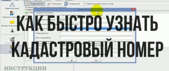
Cadastral work is...
All work related to the cadastre (taking into account real estate objects in the unified database of our state) is called cadastral work. This is a huge layer of documentation and geodetic measurements. Literally all real estate objects are placed on cadastral registration (everything that is tightly connected to the land and the land plots themselves), including power lines, roads, houses, bathhouses, garages, and sheds. The procedure for carrying out cadastral work is regulated by legislation - Land, Town Planning, Housing Codes; laws on real estate registration, cadastral activities; orders of the Ministry of Construction, Ministry of Economic Development, by-laws of local authorities.
Cadastral work on real estate
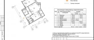
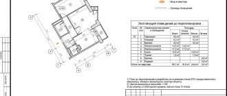
The technical plan is the result of cadastral work on real estate. It can be compiled for apartment buildings, country houses, and private residential buildings, non-residential premises, individual rooms, utility networks and structures (railroads, underground and surface communications), public places, unfinished construction projects, planned real estate objects.
Basically, cadastral work is carried out when there is a need to sell/donate/transfer for use real estate, reconstruction of a structure or redevelopment, as well as in the event of changes to the structure of the building itself (can be carried out due to various circumstances).
Based on the technical plan, the property receives a technical passport, which is necessary when determining ownership or transferring the object into the possession of another person. Sale, purchase, and exchange of structures are available only with a technical passport.
Complex cadastral work is often carried out regarding a land plot and the structure located on it. The main reason is the allocation of sites for further development.
The right to carry out cadastral works
In accordance with current regulations, to perform cadastral work, you must have permits in the form of licenses, qualification certificates, and membership in self-regulatory organizations. And this is not a complete list of permits. Among other things, the geodetic equipment with which measurements are carried out must meet the measurement requirements and be verified. The right to carry out cadastral work to prepare a boundary or technical plan belongs only to a cadastral engineer, whose status must be confirmed in Rosreestr. Measurements and surveys of land plots and other objects are carried out by specialists in the field of geodesy using special geodetic equipment. Carrying out land cadastral work is based on geodetic support in the production of cadastral work.
Main stages
The list of cadastral works includes various activities. Each of them involves the implementation of certain activities that must be carried out in the specified sequence:
● obtaining information from the cadastral authority and the register of rights;
● studying the documentation available to the customer of the work;
● carrying out measurements and research;
● processing of information received from satellites;
● signing of approval acts registered during the work by interested citizens;
● transfer of the prepared package of papers to the state cadastral authority.
Preparatory cadastral work - collection of documentation
Carrying out cadastral work begins with the expression of the will of the owner (copyright holder) of the property. At the same time, putting real estate on the cadastral register is prescribed by law, that is, it is a direct obligation, and not just the will of the owner. Otherwise, the owner will not be able to fully manage his property. In order to start cadastral work, you should first contact specialists in the cadastral field - cadastral engineers (they can be employees of geodetic and cadastral companies, and also work as individual entrepreneurs). The cadastral engineer explains what documents are needed to carry out cadastral work in each specific case. You can find a trusted specialist (with all clearances and permits) in your region using the online catalog of cadastral engineers, and you can calculate the cost of a specific contractor’s services using an online land cadastral work calculator.
How is land surveying carried out?
To carry out cadastral work during land surveying (see what land surveying is), legal grounds are required, which are based on:
- to submit an application by the owner or other copyright holder;
- checking the legal capacity of the applicant;
- compliance of information about land plots with cadastral records.
Therefore, the procedure for surveying a land plot is determined from the moment the application is submitted, with the documentation for the land survey attached. Further actions are related to the acceptance of the application after checking the legal capacity of the package of documents.
Application for land surveying.
Having accepted the application and prepayment (read more about the cost of land surveying here), unless otherwise provided by the provisions of the contract, the parties agree on the provision and acceptance of land surveying services - this is cadastral work.
Let's find out how land surveying is done. Direct land surveying and cadastral work takes place in three stages:
- preparatory work for land surveying;
- field work;
- desk work.
In general, they are aimed at identifying reliable information about the specific location of the site and its parameters. And also - entering the received entries into the State Tax Committee in accordance with the norms of the Federal Law on the State Property Committee No. 221-FZ, dated July 24, 2007.
Field work - measuring and surveying a property (plot, house, garage, etc.)
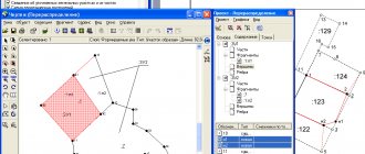
As a result of cadastral work, drawings, diagrams, maps, plans and other documents are formed. They are compiled on the basis of geodetic measurements, which are subsequently converted into cartographic information and reflected in documents in the form of coordinates and symbols. Measurements and surveys of land plots, houses, and other real estate are done by surveyors or cadastral engineers. For this purpose, special geodetic equipment is used.
Office cadastral work – data processing
After the measurement work has been completed, data processing begins. All information necessary for carrying out cadastral work is taken from legal documentation and through desk processing of geodetic measurements. So, in order to register a land plot with cadastral registration, it is necessary to prepare a boundary plan, which indicates the coordinates of the turning points of the plot, its boundaries, an act of agreement with neighbors and other documentation is attached; To register a building, premises or structure (residential building, garage, apartment, pipeline, etc.) for cadastral registration, a technical plan is prepared indicating the area of the premises, coordinates, etc.
Carrying out cadastral work - what is the result?
The result of cadastral work will be a document (land survey plan, technical plan, survey report), which will then be sent for registration to Rosreestr. There are a number of legal requirements that must be observed when carrying out cadastral work, otherwise the property will not be registered and cadastral registration will be suspended. In case of suspension, you should correct all shortcomings and apply again. As a result, registrars will enter data into a single database - the real estate register (USRN), then updated information about the property can be seen on the public cadastral map.
Cadastral work is a complex of works on the collection and analysis of documents and data, on the survey of a land plot, as a result of which specialists generate documents for state cadastral registration. As a result of state cadastral registration, the property in respect of which cadastral work was carried out is assigned various unique characteristics and the corresponding documents are issued (cadastral passport of the land plot, cadastral extract of the land plot, etc.)
The most common reason for land users to apply is the discrepancy between the information about the land plot according to the documents (area, location, etc.) and the actual one. Legal registration of the boundary of a land plot, and, if necessary, securing it on the ground is possible only when cadastral work is carried out by qualified specialists. Cadastral work - goals and objectives The main goal of cadastral work is to enter information about the land plot into Rosreestr in accordance with the actual circumstances. The result of cadastral work is a boundary plan containing current information about the land plot, subject to inclusion in the state real estate cadastre. After such an entry, the customer of cadastral work has the opportunity to formalize the rights to the land plot in accordance with current legislation or formalize changes in certain characteristics of the land plot. Entering information about a land plot is confirmed upon receipt of a cadastral passport of the land plot or a cadastral extract about the land plot. The cadastral passport must contain a number of information: Scheme-drawing of the land plot Assigned cadastral number of the land plot Area of the land plot Address of the land plot if it is assigned, otherwise a description of the location of the land plot Category of land and permitted types of its use Cadastral value of the plot Date of registration on the cadastral register accounting Information on the compliance of data on the border of a land plot with current legislation. Together with the cadastral passport, they receive a cadastral extract, which contains the following information: Information about parts of the land plot and its encumbrances A full description of all turning points on the boundaries of the plot (its coordinates). Description of the exact location of the boundaries of the site The completed cadastral passport, expressed in graphic and text form, must fully comply with the criteria given above. If the data contained in the cadastral passport is insufficient, registration of rights or transfer of rights to a land plot may be refused (for example, when registering a transaction). In the case of incorrectly entered information about a land plot into the state cadastre, such information is subject to clarification, and entering correct information is possible only based on the results of the cadastral work carried out. Thus, the main task of cadastral work is the legal registration of the border of a land plot and its fixation on the ground.