Grounds for execution of the act of demolition of OKS
The act is carried out for the following reasons:
- The owner decided to voluntarily demolish a capital facility on his land plot.
- The building collapsed due to force majeure, such as fire.
If, as a result of an accident, the building is partially destroyed, but cannot be restored, then before ordering an act, the building must be completely demolished.
Only a cadastral engineer has the right to carry out an inspection report. He certifies with his personal seal that the building no longer exists, and bears administrative and, in special cases, criminal liability for this.
The subject of the inspection report is any capital construction object that is registered in the cadastral register and the right to which is registered. It is permissible to prepare an act to deregister buildings whose rights have never been registered.
The tax on a destroyed building will cease to be charged only from the moment it is removed from the cadastral register. If the property was liquidated several years ago, but this has not been legally formalized, property taxes will still be due as usual.
Rules and requirements for drawing up an act
After contacting the organization, a cadastral engineer will come to the applicant. The analysis of the site will begin after the owner presents the following documents:
- legal;
- cadastral;
- civil passport.
On site, the specialist performs:
- inspection of the land area;
- draws up a conclusion;
- describes the state of an object.
The engineer acts when inspecting the site in accordance with the provisions of Federal Law-221 on the cadastre. When preparing documentation for cadastral works, the following rules are followed:
- papers are filled out in Russian;
- the final document reflects all information about the customer, contractor and object;
- the act is created on paper and electronic media;
- indicate the registration details of the site, describe the technical characteristics.
To assist the specialist for verification, the customer provides a cadastral passport and technical documentation describing the property being surveyed.
This is what a cadastral passport of a land plot looks like Source regionzem.ru
What is an inspection report?
This document contains information about the customer and performer of the work, the object having a cadastral number, and the documents on the basis of which the act was prepared: for example, an application from the owner for voluntary demolition.
An integral part of the act is the conclusion of the cadastral engineer. There is no graphic part in the act, and the engineer’s visit to the area is limited to inspecting the site. If there are many buildings, the engineer, using documents (for example, a registration certificate), determines the location of the demolished building and, in conclusion, confirms its absence.
Sample inspection report:
Land survey report
FEDERAL SERVICE FOR SUPERVISION IN THE FIELD OF PROTECTION
CONSUMER RIGHTS AND HUMAN WELL-BEING
(ROSPOTREBNADZOR)
Territorial Department of the Federal Service for Supervision
in the field of consumer rights protection and human well-being
in the Moscow region
(Territorial department of Rospotrebnadzor
in the Moscow region)
Territorial department <1> in ___________________________________ (name of the territorial department) LAND INVESTIGATION ACT <2> The act was drawn up ___________________________________________________________________ (date and place of drawing up the act) ___________________________________________________________________ By me (us), ___________________________________________________________________ (position, surname, first name, patronymic of the person who conducted the survey) _________________________________________________________________ , on the basis of application <3> N ______________ dated ___________________ ___________________________________________________________________, a survey of the land plot under ___________________________________________________________________ was carried out (indicate for what purposes the survey is being carried out, indicating the type of site planned for placement, __________________________________________________________________ ___________________________________________________________________ reconstruction of the object, its affiliation (name of legal entity or full name . individual) __________________________________________________________________ in the presence of ___________________________________________________________________ (Full name of the authorized representative of the legal entity or individual in whose presence(s) the survey was carried out) __________________________________________________________________ __________________________________________________________________ As a result of the survey, it was established: ___________________________________________________________________ 1. Area of the land plot ___________________________________________________________________ 2. Category of land ___________________________________________________________________ (forest fund, agricultural lands, settlement lands, etc.) ___________________________________________________________________ 3. Use of the land plot in the past and present ___________________________________________________________________ ___________________________________________________________________ 4. Purpose of use of the land plot ___________________________________________________________________ ___________________________________________________________________ 5. Location of the land plot ___________________________________________________________________ (settlement, urban district, description of the boundaries of the land plot in kind, description of the location of the plot in relation to other objects, territory) ___________________________________________________________________ ___________________________________________________________________ ___________________________________________________________________ ___________________________________________________________________ 6. Availability of sanitary protection zones of water sources, water protection zones, sanitary protection zones and other zones from objects located in the adjacent territory and (or ) having (can have) an impact on the object planned for placement, reconstruction ___________________________________________________________________ ___________________________________________________________________ ___________________________________________________________________ 7. Characteristics of the possible impacts of the object on the human environment and hygienic living conditions of the population ___________________________________________________________________ ___________________________________________________________________ ___________________________________________________________________ 8. Class of the object according to sanitary classification, size of the sanitary protection zone and possibility its organization ___________________________________________________________________ ___________________________________________________________________ ___________________________________________________________________ 9. Availability of water supply sources, the possibility of organizing a sanitary protection zone ___________________________________________________________________ ___________________________________________________________________ __________________________________________________________________ 10. Possibility of sewerage of the facility (indicating the location of wastewater discharge) ___________________________________________________________________ ___________________________________________________________________ ___________________________________________________________________ 11. Possibility of heat supply to the facility ___________________________________________________________________ ___________________________________________________________________ ___________________________________________________________________ 12. Special conditions under which it is possible to use the land plot (sanitary and epidemiological requirements) ___________________________________________________________________ ___________________________________________________________________ ___________________________________________________________________ ___________________________________________________________________ The survey report was drawn up: ___________________________________________________________________ (last name, first name, patronymic of the person (signature with transcript) who conducted the survey) The survey was carried out in my (our) presence: ___________________________________________________________________ (F.I. ABOUT. authorized (signature with transcript) representative of the legal entity or individual in whose presence(s) the examination was carried out) Attached to the act are ___________________________________________ (protocols of the studies, instrumental measurements <4>) ___________________________________________________________________ (chief (deputy) (signature with transcript) of the territorial department <5>) The report on the results of the survey received “__” _________ 200_ __________________________________________________________________ (Full name of the head of the legal entity (signature with transcript) (authorized representative), Full name of the individual (authorized representative) < 6>)
———————————
<1> For territorial departments, the full name is indicated, for the Department, a dash is placed in the line.
<2> A copy of the act remains in the file of the territorial department, the Office. This act is not an act based on the results of control (supervision) measures.
<3> The incoming number and date of the person’s application for an inspection of the land plot and the issuance of a sanitary and epidemiological certificate are indicated.
<4> If necessary, conduct such studies and measurements.
<5> For inspection reports of territorial departments.
<6> An authorized representative is a person acting on behalf of the applicant on the basis of a power of attorney. If there is an authorized representative, the date of issue and number of the power of attorney are also indicated. The power of attorney is attached to a copy of the act remaining in the territorial department, the Office.
Removal from cadastral registration of a property
If the purpose of the land plot is “individual residential building”, “garden house”, then use the following procedure for preparing documents.
- After the building is actually liquidated, an inspection report must be prepared.
Documents for ordering a certificate from a cadastral engineer:
- Land certificate (extract from the Unified State Register of Real Estate).
- Certificate of construction (extract from the Unified State Register of Real Estate).
- A free-form statement that you demolished the building on a voluntary basis.
- If the object is destroyed due to force majeure, you will need a certificate from local authorities or the fire department about the results of the fire.
- Submit the electronic version of the act to the MFC along with the application for the demolition of the OKS. The application will be printed by an MFC employee. There is no need for state duty; you must have a legal document for the destroyed object and a passport with you. Only the owner or a representative with a notarized power of attorney can submit documents to Rosreestr.
- After 10 days, a notification will be ready confirming the removal of the property from the cadastral register.
Procedure for boundary actions
On land plots (land plots), for various reasons, owners order land surveying.
A geodesic engineer coordinates structures, determines boundary lines, and measures the area of land.
This process includes a specific list of works:
- familiarity with the parameters of the subject being examined, neighboring territories and buildings according to the Unified State Register of Real Estate;
- research of legal documentation, verification of land allocation from municipal and federal funds;
- natural research of land with determination of characteristic properties, description, drawing up drawings;
- filling out and signing an agreed upon act with the owners of bordering lands.
Land survey Source yandex.net
The responsibilities of cadastral engineers include:
- conducting on-site surveys of sites to obtain accurate characteristics;
- during activities, point out registry errors and take measures to eliminate them;
- draw up a boundary and technical plan.
Upon completion of the work, the specialist indicates the size of the site in the inspection report. On this basis, Rosreestr adjusts the parameters. The conclusion of cadastral engineers may be required in order to:
- approve unauthorized construction;
- fix an error in the registry;
- justify your position in court proceedings.
To prepare for the final conclusion, the specialist will have to study the technical documentation that concerns the land, go to the site, and conduct research there. If necessary, employees of cadastral organizations appear in court, give explanations regarding professional issues, regarding:
- types, characteristics, level of complexity of the objects being surveyed;
- location, remoteness of sites;
- types and lists of construction work, the result of which required ordering a survey;
- contents of technical specifications.
From cadastral companies they order and receive:
- boundary plan;
- technical plan;
- inspection report;
- engineer's conclusion.
Example of a boundary plan Source domofond.ru
Services of cadastral institutions are paid, the cost depends on the volume of work. You can receive a certificate only after paying for a site survey. Engineers in such organizations must have qualification certification in accordance with the requirements of Federal Law-221.
See also: Catalog of companies that specialize in designing country houses
When do you need to coordinate the demolition of real estate with the authorities?
A different situation arises if the structure to be demolished is not:
- individual residential building;
- garden house;
- garage;
- auxiliary building;
- an outbuilding without a foundation.
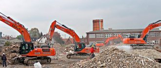
When liquidating objects not included in the specified list, it is required to coordinate their demolition with local authorities. The new procedure for the demolition of objects has been in effect since August 4, 2021, when the law on amendments to the Town Planning Code of the Russian Federation came into force.
In most cases we are talking about large objects of legal entities. Before starting the liquidation of the building in kind, the developer (technical customer) ensures the organization of demolition work and prepares a project in connection with which the building is destroyed in kind.
The demolition project is prepared by architectural and construction design organizations that have the appropriate licenses. Along with them, it is required to visit the companies involved in the operation of utility networks to disconnect from such networks.
Step-by-step procedure for demolishing a public housing complex and preparing documents for it
- Submit a notice of future demolition to the local authority.
This can be done through the MFC, the State Services portal, or in person at an authorized authority.
The draft is attached to the notification.
Within 7 days, the local government authority checks the documents, places them in the information system for supporting urban planning activities (ISOGD) and informs the construction supervision authority about the upcoming demolition.
- The developer carries out the actual dismantling of the building and notifies the local authorities about this within 7 days after the work on the site. New information is also posted in ISOGD.
- Next, the preparation of documents begins to remove the OKS from cadastral registration and cancel the right to it - for this you need an inspection report.
- The act is submitted to Rosreestr through the MFC.
- Receiving a notice of deregistration of an object completes the work on legal support of documents in connection with the liquidation of real estate.