In connection with changes in the land laws of the Russian Federation over the past few years, interest in various geodetic procedures is growing daily, in particular for the cadastral survey of a land plot, since registration in the land cadastre is a mandatory procedure, regardless of the intended purpose and area of the plot.
There are several types of shooting:
- geodetic;
- executive;
- topographic;
- cadastral;
- other varieties.
What it is?
Cadastral surveys are a list of tasks that are performed to determine the boundaries of a land plot.
Cadastral survey implies:
- geodetic measurement of the perimeter;
- coordination of measurements with neighbors;
- restoration of the boundaries of the site in the specified territory;
- establishing the boundaries of parts of the land site that are limited in use;
- development of a cadastral report.
The procedure for registering boundaries is carried out when there were none initially, or when boundary designations are lost. The need to carry out cadastral surveys is also present in cases where the land plot was provided according to previously adopted laws without properly establishing boundaries and even without drawing up the corresponding plans.
Re-determination of the boundaries of a land plot can be carried out either as a separate type of work, or as an additional measure when determining the boundaries.
IMPORTANT! New signs must be exactly the same as the old ones.
This procedure is described in detail in the instructions on setting (restoring) the boundaries of a land plot in situ (on the ground) and framing them with boundary signs.
Price
The cost of work depends on the following factors.
- Urgency.
- Plot area.
- Work report forms: provision of a site diagram or a full report in electronic and paper form.
- Bringing out boundary markers.
- Landscape.
- Remoteness of the object.
Prices for cadastral work:
| Services list | Price in Moscow | Price in Irkutsk |
| Coordination of boundaries with notice in the newspaper | 7000 rubles | 1000 rubles |
| Bringing out boundary markers | from 6000 rubles | from 3000 rubles |
| Land management examination | from 15,000 rubles | from 5000 rubles |
Purpose of geo-survey of the land plot. Where is it used?
Why is cadastral survey needed?
This is a legal document that is required in many legal situations as a basis for verifying title or as a blueprint for concluding a lease. Without this drawing, it is impossible to assign a cadastral number to the site, which makes it completely impossible to complete a transaction with real estate (receipt, sale, donation).
The document is required if:
- re-registration of rights;
- in case of loss or damage to boundary signs;
- re-establishment of boundaries if property rights to the object were re-registered without drawing up plans according to laws that are no longer in force today;
- when allocating land - in the process of preparing a land management project;
- resolution of land conflicts;
- change of purpose;
- preparation of a crop rotation project;
- preparing a project to move, remove or store the fertile layer.
The lack of a drawing, as well as the use of a plan containing technical errors, is the main cause of conflicts between neighboring landowners.
An alternative to litigation is modern cadastral survey technology. Such a service can save nerves and time on clarifying relationships - you just need to familiarize yourself with the prices for the service, which, by the way, allows you to determine the boundaries with an accuracy of a few cm.
The concept of cadastral works
The State Real Estate Cadastre (GKN) is a register containing current and reliable information about real estate objects. According to current legislation, cadastral work is designed to ensure the availability of documents that are provided to the appropriate cadastre organization for registering real estate and performing the required procedures with this object.
Carrying out cadastral work is regulated by the rules established by law. Each property is subject to certain requirements for the registration and preparation of the necessary accompanying and supporting documents.
Cadastral work is required in order to register a specific piece of real estate. Only after carrying out the required procedures can an object be considered legally existing and having a set of characteristics. These include:
- 1) Ownership;
- 2) Purpose;
- 3) Restrictions and encumbrances that apply to real estate.
Any legal actions in relation to a land plot can be carried out only after cadastral work has been completed, data has been transferred to Rosreestr and the property has been registered with the State Property Committee.
Kinds
If you combine all the procedures that are included in the cadastral survey service, you get the following set:
- Detailed determination of the location of the site;
- Establishing the size of the land plot, its area;
- Collecting information about this site that has been lost or;
- Measurements with professional equipment of coordinates and boundaries of the site;
- Coordination of adjacent boundaries;
- Installation of objects located on the specified site;
- Based on the information received, a cadastral plan is drawn up, both in written and electronic form.
Obtaining a building permit
A building permit is required not only by large developers, but also by owners of individual housing construction plots. If a topographic survey has not been carried out, you must contact a cadastral engineer. It is necessary if it is necessary to build residential and other permanent buildings.
For reference . Topographic survey is carried out before the start of construction work. On its basis, a development project is being prepared, which includes the construction in the urban planning plan of the area.
The complete package of documents is submitted to the local administration for consideration.
Preparation of a survey project
The need to survey a land plot rests with all owners. If there are no relevant documents, the plot of land cannot be sold or donated. Conducting a topographic survey is the first stage of land surveying.
After receiving the survey data, the following is indicated in the boundary plan:
- Buildings and structures available on the site.
- Buildings that are planned for construction.
- Boundary lines.
- Boundaries of the development zone.
Conducting communications
This procedure requires drawing up a situational plan for gasification and providing the site with electricity.
When conducting a survey, it is necessary to determine the location of the following objects:
- Buildings on the site and beyond.
- Transport lines.
- Electrical wiring.
- Gas pipes.
Land reorganization
This procedure may involve dividing one plot into several or combining several territories into one large plot. To do this, boundaries are drawn along the perimeter of the territory, taking into account legal norms.
As a result, the land owner is provided with topographic documentation, which contains information about the old and new site. Only after this the documents can be submitted for registration to Rosreestr.
Making cuts
According to Art. 60 of the Land Code of the Russian Federation allows for a gratuitous increase in territory up to 10% of its total area. It is also possible to purchase adjacent abandoned lands from a local organization. To obtain permission, filming is carried out. The resulting topographic plan will show the initial and subsequent layout of the land.
Attention! If surveying is not carried out and your plot is enlarged illegally, this territory can be lost in court. In addition, the judge may impose punitive damages. And if buildings are erected on illegally occupied territory, they will have to be demolished.
Thus, topographic survey allows you to solve a number of problems associated with the use and registration of land plots. The main thing is to carry it out not only taking into account the goals of the owner of the plot, but also in strict compliance with land legislation.
How topographic surveying is carried out using HYBRID technology
Where is it done and how is it done?
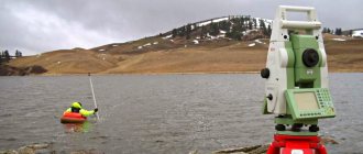
Geodetic establishment of the boundaries of a land plot involves transferring the boundaries in nature (to the terrain) according to existing planning and cartographic information.
The edge turning marks of each boundary must be securely fixed with signs in accordance with the established standard.
Transfer to nature (on the ground), as well as reconstruction of all turning points of the boundaries of the land area, is carried out using geodetic methods with the binding of at least two fixed turning points to points of the state geo-network and to points on the territory.
A cadastral survey of the land area is carried out, followed by calculation of the coordinates of the turning points of the boundaries (in a traditional or alternative coordinate system) and the area of the site. Based on the results of the work carried out, a cadastral plan of the land plot is drawn up. The established boundary signs are handed over under the supervision of the act for preservation to the owners of the land and its users.
The procedure is very simple: several people install equipment on the proposed boundaries of the site, after which, using special software, points are marked on the map, which subsequently form a contour.
The program can automatically calculate the area and exact boundaries, mark the intersection of the site with neighboring sites. The only problem may be bad weather, which slows down data transmission and may slightly distort their values.
Documentation for carrying out
- Documents confirming ownership;
- Statement by the Director of the General Directorate of Urban Construction and Architecture;
- A copy of the resolution of the territorial self-government body on the development of urban planning documentation or the implementation of design and construction activities.
- Photocopy of urban planning documents (schemes, master plans, detailed plans of territories)
For what purpose is it carried out?
The main purpose of the survey is to determine the coordinates and boundaries of a land plot and enter them into the Public Cadastral Map of Russia.
But based on the data obtained, the boundary plan necessary for registration with the state is carried out.
If the site has been canceled, or it has existed within the boundaries for more than 15 years, then you can check the presence of previously taken coordinates.
Then the cadastral engineer re-registers the boundary plan without field work.
In accordance with the new legislation, registration of a land plot can only be carried out if there is a boundary plan .
Without it, the owners will not be able to sell or donate them before they are registered in the cadastral register, although they retain the right to use.
Features of the event
The whole process can be divided into several stages, which are carried out within 14 days, depending on weather and other similar conditions.
Main stages of work
- Preparatory: technical specifications (technical specifications) are developed, a work execution plan is prepared, and planning and cartographic information is collected and analyzed. At this stage, any information about the area is studied, including legal documentation, site maps, and textual information.
- Field or production: a list of adjacent land users is drawn up and a survey is carried out. Then geodetic activities are carried out to clarify details and conflict issues.
- Desk: processing the results and signing the necessary documentation (plan M 1:1000 - 1:2000, act of establishment/restoration and transfer to nature, cartographic plan, calculation sheets, explanatory note).
The procedure for carrying out cadastral work (stages)
The implementation of a set of cadastral works in relation to a land plot is regulated by the rules established by Russian legislation. In addition to the laws indicated at the beginning of the article, the following should be highlighted:
- 1) Order of the Government of the Russian Federation dated March 3, 2012 N 297-r “On approval of the Fundamentals of State Policy for the Use of the Land Fund of the Russian Federation for 2012-2020”
- 2) Federal Law of April 15, 1998 N 66-FZ “On gardening, market gardening and dacha non-profit associations of citizens”
The process of performing cadastral work consists of several stages:
- 1) Conclusion of an agreement with the customer of the work.
The two parties involved in carrying out the work necessary for real estate accounting enter into an agreement. The contract determines the procedure for performing the work, cost and timing.
- 2) Preparatory stage.
At this stage, cadastral service specialists collect, systematize and analyze available data about the site (archival cartographic materials). Specialists must have up-to-date information to perform their functions efficiently. To do this, the following documents are requested:
- Extract and cadastre of real estate;
- Land cadastral plan for a specific land plot;
- Catalog of site coordinates and local reference network;
- Documents containing information about objects and subjects of the right to real estate.
- 3) Complex of field work.
Specialists coordinate the location of the site and inform interested parties about the work being carried out. Next, specialists perform an instrumental determination of the exact position of the turning points of the site boundary. The error of this stage of work is up to 0.5 mm.
- 4) Desk stage.
During this stage, a package of documents is compiled, which are transferred to the customer and to the relevant government body responsible for maintaining the real estate cadastre.
The procedure for performing cadastral work is described in the Federal Law of July 24, 2007 N 221-FZ “On the State Real Estate Cadastre”. The timing of the work is not specified in the laws, therefore it is determined by agreement between the customer and the contractor.
What to choose - cadastral or geodetic survey?
Among the terms of land use there are such concepts as geodetic and cadastral survey. Geodetic survey (or survey) is a broader concept that relates more to methodology. This is complex work, the results of which serve as the basis for other projects, including cadastral surveying. They are carried out by surveying engineers. The goals of IGI (engineering geodetic surveys) are:
- studying the terrain and depicting it on a map;
- linking linear structures, geological developments, underground communications, hydrological sections to the situation on the ground.
A cadastral survey is needed to obtain complete information about a land plot and enter information about it into the state real estate cadastre:
- boundaries of the memory;
- categories of land;
- territorial zones;
- red lines;
- buildings and structures;
- lands and public areas, etc.
In this article we will look at how geodetic survey differs from cadastral survey.
Executive shooting
At the final stage of the construction process, as-built surveys are carried out in order to assess the actual position of newly built structures, their elements, shape, size and their compliance with design data.
During and after the construction process, records of work performed are kept. To determine the position in plan and height of the structures being built and their parts, special geodetic measurements are made, the totality of which is called as-built survey.
Not all parts of structures are subject to executive survey, but only those on which the strength, stability of structures, accuracy of installation, and subsequent operating conditions depend. Typically, the work project establishes a list of those parts of the structure that are subject to as-built surveying. The work of producing as-built surveys is carried out by the customer, or, on his instructions, by the design organization that developed the project for this construction project.
When checking the quality of construction of those parts of the structure that will be covered with other parts and elements during subsequent construction work, intermediate as-built surveys are carried out with the preparation of the necessary reporting documentation (plans, profiles, etc.).
As-built surveys are carried out using a geodetic alignment basis for construction. Geodetic control is carried out by measuring elevations, distances, angles relative to reference axes and points with recording of the results in special sheets or on magnetic storage media. As a result of the completed control geodetic work and executive surveys, all deviations of the constructed structure from the design are established, ways to eliminate them are outlined, a decision is made to continue subsequent construction work, or the completed object is accepted with an appropriate assessment of the quality of construction.
The measurement error during as-built surveys is allowed to be no more than 0.2 of the deviations provided for by building codes and regulations, state standards or design documentation.
Based on the results of the executive survey, an executive master plan is drawn up, noting on it all deviations from the project. The executive master plan serves as the main document for the acceptance of a completed facility, and is also used during its subsequent operation and reconstruction.
Controlling the verticality of a row of columns
The verticality of a row of columns is most often controlled by a theodolite from a line parallel to the main axis of the row of columns (Fig. 109). With a telescope directed parallel to the axis of a row of columns, one sights on a rod or Drozdov’s device, fixed in the upper part of each column in turn, and makes a count. The reading should be equal to the distance between the axis of the row and the line on which the theodolite is installed.
When installing columns, deviations from the design should not exceed the following tolerances:
– deviation of the column axes in the lower section relative to the marks of the alignment axes – 8 mm;
– deviation of the column axes from the markings of the alignment axes in the upper section, respectively, with a column height of over 4 m to 8 m – 15 mm; deviation of the elevations of the supporting surfaces of the foundations of the columns from the design ones is 3 mm (SNiP 3.03.01-87 “Load-bearing and enclosing structures”).