Definition of the concepts of PPT and PMT
A land surveying project, abbreviated as PMT, is a type of documentation related to urban planning. It is used if it is necessary to divide one large area into smaller components. It is important to note that the project is publicly available on the official portal of architectural departments.
The next term PPT stands for territory planning project - it refers to a group of urban planning information, contains detailed information about the objects located on the site, their features and parameters. The documents specify future buildings and where they will be located.
What are PPT, PMT and how do they differ?
A territory planning project (PPT) is an urban planning document that shows which objects and in which zones are located on the ground. It is developed not for an entire settlement, but for its large units: for example, for a microdistrict, a block.
Shows the location of squares and streets, public gardens, capital construction projects, boulevards, railway lines, etc. PPT may be required to obtain permission for infill development, the construction of structures on one site. On its basis, a PMT is created.
A territory surveying project is a document that shows the boundaries and area of all plots located within the block. Needed to register the land area under a residential property or commercial building and the adjacent area for cadastral registration. Based on it, a boundary plan is created.
PPT and PMT can be developed jointly or separately. They have a number of similar features and characteristics. Both documents are prepared regarding a linear object or area. The differences between the land surveying project and site planning are in the table.
| Comparative criterion | PPT | PMT |
| The essence | Describes what and where is located on the territory. | Marks a piece of land. |
| Purpose of creation | Needed for the construction of various structures, laying communications. | Providing the technical ability to survey the territory. The need to create such a document arises when developing a site, allocating it for use or ownership. |
| Detailing | Contains greater detail of the characteristic features of a separate territory. | Is less detailed. |
| What information is contained | Geodetic points and location diagrams of roads, houses, utility networks and other objects. | Information on the allocation of plots from the general territory, on plots dividing the land into parts. |
The project for surveying the territory of a linear facility is an integral part of the PPT.
The planning and land surveying project are two closely interrelated documents. They enable the land owner to realize his ideas regarding construction and carrying out certain manipulations with the site.
Why are land surveying and planning projects needed?
Regulated by art. 42–43 GrK RF. The articles contain a list of reasons on the basis of which it is necessary to draw up a project for planning and surveying a site. In particular, they help to define boundaries, highlight parts, etc.
For the formation of land plots
“Formation” refers to the division of one large area into smaller components. For example, separation of the encumbered part from the general land territory.
It is necessary to draw up a land surveying plan if you need to allocate part of the land provided by the municipality for a gardening, dacha partnership (hereinafter referred to as SNT) or other non-profit organization. In a situation where individual individuals, SNT participants, wish to have their own territory, it is necessary to first draw up an appropriate project, then begin land surveying.
There is an exception that applies to SNT. If a development project was drawn up and approved before 2018, then the territory is divided in accordance with it. Therefore, there is no need to engage in land surveying (Federal Law No. 66). The norm is valid until 2021.
If an agreement has been drawn up on the further development of a land plot, then it is necessary to prepare a corresponding project, because inevitably in the future there will be a separation of parts from the general territory.
It is possible to form an absolutely new land plot if the municipality decides to transfer the territory to the ownership of a specific person (Article 29 of the Land Code of the Russian Federation). For this purpose, a land surveying project is drawn up.
To establish red lines
Projects help to establish boundaries and highlight specific objects located on the territory (Articles 42–43 of the Civil Code of the Russian Federation). This is done thanks to special red lines. On the project they mark the boundaries of public areas. These include parks, squares, streets.
Red lines also indicate the boundaries on which various communications are located, for example, roads and railways, pipelines and power lines.
To obtain a building permit
It is impossible to obtain a building permit without providing a corresponding approved land surveying project, because the plan confirms that:
- legal requirements regarding urban planning are met;
- the building is being erected on a landfill, the category of which does not prohibit this.
If a citizen submitted a land surveying project, he prevented the possibility of further demolition of the house and receiving a fine of 5 thousand rubles in accordance with Art. 9.5 Code of Administrative Offenses of the Russian Federation.
Features of the planning and land surveying project for a street or neighborhood
Planning and land surveying projects for built-up areas and streets must strictly comply with urban planning standards. The projects take into account such parameters as transport, engineering infrastructure, water supply, sewerage, drainage, heat supply, telephone installation, electricity supply, economic and technical equipment, and protection of natural resources. The attached drawings should reflect communal, linear objects, landscaping elements, existing and planned buildings and structures.
Composition of the land surveying project
The plan begins with the first title page. It contains information about the contractor, information about the content and structure of the project.
The plan consists of several parts (clause 5 of article 22 of Federal Law No. 218):
- text;
- blueprints.
Let's take a closer look at each of them.
Text part
The next page after the title page is the contents of the project. It records the parts with page numbers. The number of sheets depends on the specifics of a particular plan, so it can vary greatly. Only the order of presentation of the essence of the document and the form are similar.
The text part includes (Article 22 of Federal Law No. 218):
- primary information (data about the documentation provided by the owner);
- a special explanatory note containing information about the memory;
- a list of property owners, a few words about each;
- complete data about the general area from which the part is allocated.
The paper must be agreed upon with the owners indicated in the list and approved.
Blueprints
Drawings form the graphic part of the plan. Standardly located on an A4 sheet, but it is permissible to increase the size for a map image.
Drawings contain:
- boundaries;
- cadastral number;
- coordinates;
- boundary signs;
- square;
- neighboring areas.
The plan is drawn up by hand or using specialized programs on a computer. When the performer draws the graphic part independently, it is necessary to use a pen with blue ink.
Corrections are acceptable, but must be certified by the seal and signature of the cadastral engineer who approved the project.
Justification materials
The part has boundaries:
- natural objects that are protected by the state;
- areas with special conditions of use;
- objects that have historical or cultural value;
- areas of capital construction territory.
Preparation requirements
Contained in Art. 22 Federal Law No. 218. There are several important requirements when drawing up a land survey plan:
- information is located on paper;
- two or more copies are compiled; at the customer’s request, the project is provided in electronic form;
- the document is stitched and certified by painting and seal, which is located on the first (title page) of the project, on the last sheet, directly on the specific plan;
- compiled using special computer programs and graphics, it is possible to combine methods, that is, fill out by hand and using technology;
- It is mandatory to number each sheet, with the exception of the appendix;
- if the field is not filled in, do not delete it, just put a dash;
- information in the plan is entered from the information contained in the plan and the cadastral extract;
- filled out in Russian using Arabic numerals;
- there are special rules when transferring information from section to section or to the next sheet;
- special cartographic data and documentation related to land development are used.
Step-by-step instructions for preparing PMT and PPT
The sequence of preparation of PMT and PPT projects is similar, since the documents are similar to each other. Plans are prepared in the administration or in a private organization. The municipality does not always provide such services, therefore, before submitting an application, you need to clarify the question.
An application is made to a special authorized person. The following documents are attached:
- a sketch of the master plan and additionally a drawing of communications;
- extract from the land cadastre;
- topographical diagram with communications;
- a document indicating the absence or presence of permanent structures on the territory.
After providing the specified documentation, work on preparing the plan begins. Experts rely on the documents attached to the application. Attention focuses on:
- architecture;
- soil features;
- technical equipment;
- environmental friendliness of the work being carried out;
- the final result.
If the decision is made in favor of the applicant, then a special technical assignment is drawn up. Next, the corresponding cadastral activities take place. The PPT and PMT are compiled. The second project will be further coordinated with the water utility and electrical networks. This happens at organized public hearings. The procedure is absolutely free. Performed over a period not exceeding two months.
It is necessary to submit an application to a commercial company if the municipality refuses. The applicant enters into an agreement with a legal entity, providing a similar list of papers.
The exception is the master plan. It may not be provided. The preparation period will be reduced to one month. The price is directly related to the amount of work done, so it can vary greatly depending on the specific situation.
Who prepares and approves it?
According to the eighth part of Article No. 45 of the Civil Code of the Russian Federation, the preparation of PMT and PPT can be carried out by local executive authorities or self-government. To draw up such documents, you need to contact the Department of Urban Planning and Architecture, which is located under the administration.
The following documents will be required:
- a sketch of the general plan of the land plot indicating the locations of communications;
- certificate of ownership;
- cadastral extract and passport of the territory;
- topographic plan.
Based on these papers, a project will be prepared.
If the local administration refuses to draw up the necessary documentation, then you can contact a commercial architectural company that specializes in the formation of PPT and PMT. The organization must have a license to carry out the relevant work. Local authorities are responsible for coordinating land surveying and planning projects.
Approval is entrusted to the following committees:
- on issues of maintaining order;
- on energy and engineering support;
- on environmental protection;
- management of the area in which construction work will be carried out;
- on road development;
- for the protection of historical and cultural monuments.
Project approval
The approval is regulated by Art. 45–46 GrK RF. The procedure is the approval of a land surveying and planning project as one document, which indicates the further plan for the construction of the house and land surveying. This can be realized provided that:
- construction takes place on a built-up land plot;
- similar documents were previously approved.
Otherwise, each project is agreed upon independently and is not presented as a single document.
The approval procedure consists of several important steps:
- analysis of received documents;
- providing the results of the audit.
The transferred papers are subject to comparison for compliance with legal norms. Only the main part (development parameters, location of permanent buildings, characteristics of the area, etc.) is reviewed and approved. Justification materials are not analyzed.
The plan is approved by the urban planning department. The period for reviewing papers does not exceed one month.
Based on the results, if the outcome is positive, a corresponding order from the government body is issued. Be sure to make a copy of the document. The original order is transferred to the customer, and a copy remains in the department for the archive.
The approved plan is posted on the official Internet portal of the municipality.
Territory survey project
1. What is a territory surveying project?
2. Why is a territory surveying project necessary?
3. Who should make a decision and prepare a project for land surveying?
4. Preparation of a land surveying project.
5. Approval of the territory surveying project.
What is a land surveying project?
Territory surveying project
is a document on territory planning, which is developed only in relation to built-up areas and areas subject to development (Article 43 of the Town Planning Code of the Russian Federation).
The main purpose of preparing a territory surveying project (TMP) is:
- determining the location of the boundaries of formed and changed land plots;
- establishing, changing, canceling red lines.
A land surveying project is usually developed simultaneously with a territory planning project, which in turn also refers to territory planning documentation (Part 4 of Article 41 of the Town Planning Code of the Russian Federation). The main difference between these documents is the following. The territory planning project highlights the elements of the planning structure. Whereas in a territory surveying project, the boundaries of land plots of one or several elements are established (part 1 of article 42, part 1 of clause 1 of part 2 of article 43 of the Town Planning Code of the Russian Federation).
As a rule, the territory planning project is the basis for its land surveying project. In this case, it is allowed to prepare a territory surveying project without preparing a territory planning project in relation to a territory within the boundaries of which activities for the integrated and sustainable development of the territory are not envisaged, and the placement of linear objects is not planned. Therefore, the territory surveying project can be included in the territory planning project or drawn up as a separate document (Parts 5, 6, Article 41 of the Town Planning Code of the Russian Federation).
The territory surveying project consists of the main part, which is subject to approval, and materials to justify this project. The main part of the territory surveying project includes a text part and territory survey drawings.
The text part of the territory surveying project contains:
- list and information on the area of land plots to be formed, including possible methods of their formation;
- a list and information about the area of land plots being formed that will be classified as public areas or public property;
- type of permitted use of the land plots being formed in accordance with the territory planning project;
- purpose of the forests, type(s) of permitted use of the forest area, quantitative and qualitative characteristics of the forest area, information about the location of the forest area within the boundaries of specially protected forest areas (if the preparation of a land surveying project is carried out in order to determine the location of the boundaries of the formed and (or ) modified forest areas);
- a list of coordinates of characteristic points of the territory’s borders in the coordinate system used to maintain the Unified State Register of Real Estate (USRN).
The following information is displayed on survey drawings:
- boundaries of planned and existing elements of the planning structure;
- red lines;
- indentation lines from the red lines in order to determine the locations of permissible placement of buildings, structures, and structures;
- the boundaries of the land plots being formed and (or) being changed, the conventional numbers of the land plots being formed, including in relation to which they are expected to be reserved and (or) withdrawn for state or municipal needs;
- boundaries of public easement zones.
Why is a territory surveying project necessary?
A territory surveying project is necessary in the following cases:
—
for the formation of land plots
from state and municipal lands (clause 1, clause 1, article 11.3 of the Land Code of the Russian Federation). The land surveying project determines the boundaries of the created and changed areas located on the territory in respect of which it is being drawn up.
If a land surveying project is approved for a territory, the formation of the land plot will be carried out in accordance with this project. If it is not approved, the plot can be formed in accordance with the approved layout of the land plot on the cadastral plan of the territory (Clause 2 of Article 11.3 of the Land Code of the Russian Federation).
Some land plots can only be formed according to a territory surveying project. This applies to those areas that are formed (clause 3 of article 11.3 of the Land Code of the Russian Federation):
- from a site that is provided for the integrated development of the territory;
- from a plot that is provided to a horticultural or vegetable gardening non-profit partnership;
- within the boundaries of the territory in respect of which an agreement on its development has been concluded;
- within the boundaries of an element of the planning structure, which is built up with apartment buildings;
- for the construction (reconstruction) of linear facilities of federal, regional or local significance.
—
to establish red lines ,
change them or cancel them:
- in a built-up area where the construction of new real estate is not planned;
- on a formed (modified) land plot within the boundaries of the territory in which activities for the integrated and sustainable development of the territory are not provided. At the same time, the establishment, modification and abolition of red lines can only change the boundaries of public areas.
The location of the red lines must be taken into account, for example, during construction (reconstruction, major repairs) of objects.
— to obtain a building permit
(Part 3.1, Clause 2, Part 7, Article 51 of the Town Planning Code of the Russian Federation):
- apartment buildings, if construction will be carried out as part of the integrated development of the territory on leased lands of state or municipal property;
- linear objects, except for cases when their construction does not require territory planning documentation (Resolution of the Government of the Russian Federation of March 7, 2021 No. 269 “On approval of the list of cases in which the preparation of territory planning documentation is not required for the construction or reconstruction of a linear object ").
Who should make the decision and prepare the territory surveying project?
To prepare a land surveying project, a decision must first be made, after which the project itself is prepared.
Depending on the situation, the following authorized bodies make a decision and prepare a project for land surveying (Part 1 of Article 45 of the Town Planning Code of the Russian Federation):
- local government body of a settlement or urban district in relation to the territory that is located within the boundaries of the settlement or urban district (Part 5 of Article 45 of the Town Planning Code of the Russian Federation). In practice, most cases fall into this category;
- local government body of a municipal district, if objects (including local ones) are located on the territory of several settlements and (or) inter-settlement territory within the boundaries of the district (Part 4 of Article 45 of the Town Planning Code of the Russian Federation);
- executive authority of a subject of the Russian Federation, if the object (including of regional significance) is located on the territory of two or more municipal entities (municipal districts, city districts) within this subject of the Russian Federation (Part 3 of Article 45 of the Town Planning Code of the Russian Federation);
- an authorized federal body when it is planned to locate objects on the territory of several constituent entities of the Russian Federation, including closed administrative-territorial entities, the boundaries of which do not coincide with the borders of the constituent entity of the Russian Federation (Part 2 of Article 45 of the Town Planning Code of the Russian Federation). As a general rule, such a body is the Ministry of Construction of Russia.
In cases where the construction (reconstruction) of an object of local (regional) significance is carried out on the territory of several settlements (city districts, districts), subjects of the Russian Federation that have a common border, the authorities of that municipal formation of the settlement (city district, district) must make a decision and prepare a project. , a subject of the Russian Federation, at the expense of which construction (reconstruction) will be carried out. In this case, coordination is carried out with the authorities of settlements (city districts, districts), subjects of the Russian Federation, on the territory of which the objects will be located (parts 3.1 4.1 5.1 of Article 45 of the Town Planning Code of the Russian Federation).
At the same time, urban planning legislation (since January 1, 2017) provides for a number of cases when territory planning documentation is developed on private initiative. Thus, the decision to develop planning documentation can be made independently (Part 1.1 of Article 45 of the Town Planning Code of the Russian Federation):
1) persons with whom contracts have been concluded:
- on the development of built-up areas;
- on the comprehensive development of the territory, including the construction of standard housing;
- on the integrated development of the territory at the initiative of local governments;
2) copyright holders of existing linear objects subject to reconstruction, in the case of preparation of documentation on the planning of the territory for the purpose of their reconstruction;
3) rights holders of a land plot or real estate (one of such rights holders) participating in the integrated development of the territory on the initiative of the right holders;
4) subjects of natural monopolies, organizations of the public utility complex in the case of preparing documentation on the planning of the territory for the placement of objects of federal significance, objects of regional significance, objects of local significance;
5) by a horticultural or vegetable gardening non-profit partnership in relation to a plot of land provided to such a partnership for gardening or vegetable gardening.
When making a decision on the development of territory planning documentation, these persons ensure that the relevant work is performed at their own expense.
Preparation of a land surveying project.
As a rule, to prepare a land surveying project, you need to contact an authorized body, except in cases where the decision to prepare a land survey project is made on a private initiative.
The authorized body makes a decision on the preparation of documentation on the planning of the territory (including its land surveying project) and publishes it within 3 working days
from the date of the decision in official sources and on your website (if available). After this, you can submit to the authorized body your proposals on the procedure, timing of preparation and content of the territory surveying project (Parts 1-3 of Article 46 of the Town Planning Code of the Russian Federation).
In this case, authorized bodies can independently prepare a land surveying project, institutions subordinate to them or persons contracted for this purpose, as well as you yourself on your own initiative (Part 8 of Article 45 of the Town Planning Code of the Russian Federation).
If you decide to prepare a land surveying project yourself (in cases provided for by law), the responsibility for preparing the project rests with you. Within 10 days from the date of the decision, send a notice of your decision to the head of the settlement or urban district (Part 7 of Article 45 of the Town Planning Code of the Russian Federation). You can prepare a land surveying project yourself; there are no restrictions for this. However, this requires special knowledge, so it is better to contact a specialized organization (Part 1.2 of Article 45 of the Town Planning Code of the Russian Federation).
When preparing a land surveying project, the boundaries of the created and (or) changed land plots are determined in accordance with urban planning regulations, norms for land allocation for specific types of activities, as well as other established requirements for such plots, technical regulations, and sets of rules.
Preparation of land surveying projects is carried out taking into account materials and results of engineering surveys. It is possible to use materials that were received for the preparation of a territory planning project, provided that the period of 5 years from the date of their implementation has not expired (part 1 of article 41.2, part 8 of article 43 of the Town Planning Code of the Russian Federation).
Engineering surveys are carried out in order to obtain:
1) materials on the natural conditions of the territory in respect of which the land surveying project is being prepared, and the factors of technogenic impact on the environment, forecasts of their changes in order to ensure the rational and safe use of the specified territory;
2) materials necessary to establish the boundaries of the zones of the planned location of capital construction projects, clarify their limit parameters, establish the boundaries of land plots;
3) materials necessary to justify the implementation of measures to organize surface water flow, partial or complete drainage of the territory and other similar measures, engineering protection and improvement of the territory.
The procedure for performing engineering surveys is established in the Rules approved by Decree of the Government of the Russian Federation dated March 31, 2017 No. 402 (hereinafter referred to as the Rules for performing engineering surveys).
No research required
in the following cases (clause 2 of the Rules for carrying out engineering surveys):
1) if there are enough engineering survey materials that are located in:
- information systems for supporting urban planning activities (Information from the systems is provided for a fee. Its maximum amount for obtaining information contained in one section of this system is 1,000 rubles);
- federal state information system for territorial planning;
- State Fund of Materials and Engineering Survey Data;
- Unified State Data Fund on the state of the environment and its pollution;
- schemes for the integrated use and protection of water bodies;
- state water register.
The sufficiency of such materials is determined by the initiator of the preparation of the territory surveying project or by you yourself, if the preparation of the project is carried out independently. This must be done before making a decision on preparing a land surveying project (clause 4 of the Rules for Conducting Engineering Surveys);
2) you can use previously completed engineering surveys if the statute of limitations for their completion allows (5 years for the use of materials prepared for the territory planning project).
Approval of the territory surveying project
The project is approved by the authorized body. In most cases, such a body is the local government body of the settlement (urban district). If you prepared the project yourself, then send it to the appropriate authority (Part 3.1 of Article 46 of the Town Planning Code of the Russian Federation).
Before approval of the project, the local government body (Parts 4-5 of Article 46 of the Town Planning Code of the Russian Federation):
1) checks the project’s compliance with established requirements within 20 working days from the date of receipt of documents. Based on its results, the project is sent to the head of the settlement (urban district) or returned for revision;
2) ensures consideration of documentation at public discussions or public hearings or rejects such documentation and sends it for revision. The duration of public discussions or public hearings cannot be less than 1 month
from the day residents are notified of their holding and
more than 3 months
before the day of publication of the results of discussions or hearings and is established by the charter of the municipality or a regulatory act of its body (Part 11 of Article 46 of the Town Planning Code of the Russian Federation).
Public discussions and public hearings are not held if the land surveying project has been drawn up (part 12 of article 43, part 5.1 of article 46 of the Town Planning Code of the Russian Federation):
- in the form of a separate document for the territory, which is located within the boundaries of the element (elements) of the planning structure, approved by the territory planning project. An exception is made for projects prepared to establish (change, cancel) red lines in connection with the formation and (or) change of a land plot located within the boundaries of the territory. At the same time, integrated and sustainable development is not provided for such a territory, and the establishment (change) of red lines only changes the boundaries of the public territory;
- for a territory within the boundaries of which the rules of land use and development provide for activities for the integrated and sustainable development of the territory;
- for the territory within the boundaries of a land plot that is provided to a horticultural or vegetable gardening non-profit partnership;
- for the territory on which linear objects are located within the boundaries of forest fund lands.
If discussions or hearings were held, then the local government body, taking into account the protocol and conclusion on the results of public discussions or public hearings, no later than 20 working days
from the date of publication of such a conclusion, makes a decision to approve the territory surveying project or rejects such a project and sends it for revision ( ).
The head may reject and return for revision a land surveying project prepared by you yourself (in cases provided for by law), only if it does not meet the requirements specified in Part 10 of Article 45 of the Town Planning Code of the Russian Federation (Parts 12 13, 13.1 of Article 46 of the Town Planning Code of the Russian Federation).
In cases where discussions and hearings are not held, the procedure for approving the project depends on the situation. For example, with the integrated development of a territory at the initiative of copyright holders, the territory surveying project is checked within 30 days
from the date of its receipt by the local government body. Based on the results of the inspection, it is approved or rejected and sent for revision (Part 10, Article 46.9 of the Town Planning Code of the Russian Federation).
After approval of the territory surveying project, the local government body must:
- publish it in official sources and, if available, on your website within 7 days
from the date of its approval (Part 14 of Article 46 of the Town Planning Code of the Russian Federation); - send the project (the information contained in it) to Rosreestr for its inclusion in the register of boundaries of the Unified State Register of Real Estate within 5 working days from the date of its approval (part 4 of article 10, clause 13 of part 1 of part 20 of article 32 of the Federal Law of 13.07 .2015 No. 218-FZ “On state registration of real estate; hereinafter referred to as the Law on Real Estate Registration).
If information about the territory surveying project is not included in the Unified State Register of Real Estate in the manner of interdepartmental information interaction, you can independently contact Rosreestr with the appropriate application (Part 1, Article 33 of the Law on Real Estate Registration).
Reasons for refusal
There are a number of significant reasons due to which an applicant will be denied approval of a land management plan:
- the rules prescribed in Articles 42–43 of the Civil Code of the Russian Federation were violated;
- people living in the specified territory express obvious dissatisfaction;
- the plan conflicts with the territory planning project;
- Serious violations of mandatory standards, such as construction standards, have been identified;
- the rules for providing papers established by law were ignored.
If a decision is made to refuse the applicant, the government agency provides detailed explanations justifying the reason for this outcome.
Samples for reference
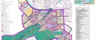
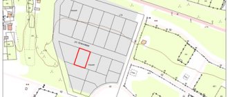
Below you can see a sample title page of the land surveying plan:
With project drawing:
One of the sheets of the storage plan:
See the site planning project:
It is quite difficult to prepare the presented drawings and graphics, but it is necessary. After all, this allows you to expand the possibilities of using memory and build large-sized buildings.