What are the installation requirements for this entry not to appear?
Proper registration is carried out by cad. engineer, as a result of which the following are entered into Rosreestr:
- coordinates of the memory turning points;
- memory circuit;
- text description of earth parameters.
The indicated information is certified by an enhanced electronic seal of the cad. engineer and are transmitted electronically to the information bank of the State Property Committee.
The completed documents are transferred to the customer on paper, with reports attached.:
- on transferring the coordinates of turning points to the owner;
- agreeing on the end of your land with your neighbors.
Download these documents for review:
- The act of drawing out the boundaries of the land plot and the breakdown of buildings.
- Boundary approval act: form and completed sample.
If at least one of the above points does not apply to you, this means that your legal framework was set incorrectly, the rules (and, as a result, the law) were violated, and in the records of the State Property Committee you will see the very record discussed in the article.
Clarification of the boundaries of the land plot
Cadastral registration in connection with a change in the area of a land plot and (or) a change in the description of the location of its boundaries, with the exception of cases of formation of a land plot during separation from a land plot or division of a land plot, in which the converted land plot remains within the changed boundaries, is carried out provided that such changes are related to clarification of the description of the location of the boundaries of a land plot, the cadastral information about which does not comply with the requirements established on the basis of this Federal Law for the description of the location of the boundaries of land plots.
What if this post applies to you?
There are two options: either you carry out the land surveying procedure, or you can start legal proceedings with the old companies if you once surveyed the land. If you haven’t been surveyed or don’t want long legal battles, continue reading.
You need to contact a geodetic company that provides the relevant services based on a special license.
Only legally capable persons have the right to submit an application.:
- owner of the land plot;
- another title owner;
- co-owners of one plot;
- a representative acting in the interests of the owner.
When drawing up an application for land surveying, with the establishment of boundary lines dividing the land plot, the following is required:
- It is mandatory to present the civil passports of the copyright holders and the title document.
- Representatives are required to provide a notarized power of attorney from the owner.
- In the application, indicate the reasons for the survey.
- Pay a proportionate amount corresponding to the cost of services.
Application for land surveying.
On the appropriate day, you should meet with the service provider on your own land . This day is set in advance and agreed upon by the parties. Surveyors take measurements using high-precision satellite equipment and transmit information on the measurements to the cadastral engineer.
When carrying out land surveying, you need to notify neighbors in the form of a notice.
Notifying neighbors about land surveying.
Based on geodetic work:
- At turning points, permanent or temporary boundary signs are installed.
- The cadastral engineer makes a report and transmits the information to the customer and to the State Property Committee.
Final actions are divided into three groups, described below.
If everything is fine and you can register the memory
Information is transmitted to Rosreestr in accordance with established standards. The customer receives a boundary document, which must contain an act on the coordination of boundary boundaries with neighbors . In this case, the act is signed at the request of the owner or cad. engineer
After registering the property for cadastral registration, you can:
- clarify the boundaries of the memory;
- change boundaries (expand or reduce).
In any case, read the paragraph of this article again “What are the requirements for installation so that this entry does not exist?” – all the points with which you must complete the procedure for installing the edges of the earth are indicated there.
If neighbors refuse to sign the act
In this case, you will need to send a registered letter with a notification that you need to sign a border approval act..
If after a month no response is received, then based on the documents received at the post office, you need to go to the notary’s office and register the refusal to sign.
In case of refusal, land surveying can be carried out without the consent of the neighbors.
In disputes with neighbors
If the reaction to the signing turned out to be negative or if a dispute obviously arose about the territory of the plots, it is necessary to file a claim with the court at the location of the land plot . In this case, the cadastral engineer can act as an expert on the issue on behalf of the plaintiff.
Statement of claim to establish the boundaries of a land plot.
What to do if the boundaries of the site are not established?
To prevent unidentified plot boundaries (PL) from causing problems, the new owner of the land should carry out a land surveying procedure. To do this, the owner or title holder must contact a surveying firm.
Co-owners of the plot or a representative of the landowner with a power of attorney from a notary also have the right to submit an application. An application for a land surveying procedure is drawn up in accordance with the legally established procedure, taking into account the specifics of the legislation.
For the procedure you will need:
- Present the landowners' passports and a document confirming the right to own the land.
- Indicate the reasons for land surveying in the application.
- Pay for geodetic work.
From January 2021, every land owner undertakes to establish the exact boundaries of the land plot by cadastral number, since otherwise he will not be able to sell, mortgage or exchange it. Before the adoption of this law, some lands were assigned conditional numbers according to the cadastre, which were recorded in the State Property Committee.
They did not contain coordinates of turning points and corresponded to the so-called “dacha amnesty” method. In such cases, the fact of the absence of land surveying can only be revealed if the boundary limits of the land are violated.
According to Art. 7.1. Code of Administrative Offenses of the Russian Federation, unlawful use of a site, for example, the construction of buildings and structures on it, entails the imposition of a fine, the amount of which varies between 1-1.5% of the cost of the land plot.
The lack of land surveying can also cause conflict with neighbors if the fence is installed within the boundaries of the land plot or the coordinates of the boundaries have not been identified.
What to do if there is a record, but the land survey was definitely carried out and the document is in hand?
Sometimes this happens even if you have an agreement in your hands. Most likely there was a clerical error somewhere. Don't be afraid. We contact the cadastral registration authority, show the documentation and otherwise correct the error.
Less often, but unfortunately, situations also occur in which land surveying was carried out completely in accordance with the requirements of land legislation, but at the very last moment, when the land survey plan was being drawn up, some mistakes were made. Here we turn to the paragraph of this article, where it is written how to set the boundaries of the land, because this is the only way out of the current situation. There is no way to correct such a mistake, only to re-marry the land. Well, or go to court. We can tell you from experience – it’s better to define your boundaries again.
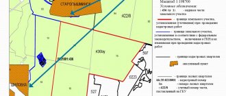
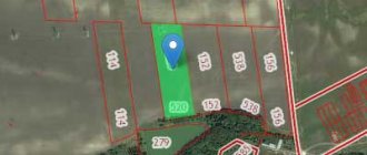
The boundary of the plot of land is not established - what does this mean?
According to Federal Law 221 and in accordance with the requirements of land legislation, the limits of land use must be established taking into account the regulations. The presence of accurate information gives the landowner the opportunity to put his plot on the cadastral register and officially register it with Rosreestr.
The registration procedure requires a full package of documents, including an act confirming the agreement of the boundaries of adjacent plots with neighbors in the SNT or other land users.
The registration of the act is carried out by a cadastral engineer; this document includes:
- schematic representation of the storage limits;
- turning points of borders and their coordinate location;
- detailed description of border parameters.
After carrying out the procedure, the engineer transfers the scanned document, certified by a seal, to the Unified State Register of Real Estate (formerly it was the State Property Committee). Copies of documents remain with the owner of the memory; their list includes acts on the approval of limits and coordinate data of turning points.
If the procedure was not carried out for one reason or another, the documents for a certain land plot located in the Unified State Register will indicate that the border was not established in accordance with the law. This means that if you intend to sell the property, the transaction will not be registered.
This situation can also arise as a result of the loss of the deed, then the question: what does it mean to define the boundary of the site as not established, requires a more detailed investigation. This may lead to litigation with neighbors or other persons who may use someone else's land or violate the boundaries of the land plot during the construction process.
What to do if disputes arise with neighbors
Often, uncertain boundaries of land plots become a stumbling block when agreeing on these parameters with neighbors. Land surveying allows you to prevent this problem, because if it comes to judicial debate, the court’s decision will be based primarily on the fact that the characteristic points have been designated, because they can be used to track possible violations of the rights of third parties.
Find out where to start legalizing redevelopment. How to register a plot of land as a property? Instructions follow the link.
Read all about the extract from the Unified State Register of Real Estate on the transfer of rights to a property in the article.
In the event that a dispute arises during which it is not possible to resolve peacefully the placement of a fence separating the plots, it is necessary:
- Contact the authorized bodies with a request to carry out land surveying.
- To respect the interests of all parties interested in how the territory will be correctly demarcated, all neighbors are notified in writing before the event. On the appointed day they must be present at the site.
- If the notification has been repeatedly ignored, land surveying is allowed in the absence of a third party.
- If there are further claims and disagreement with the results, neighbors have the right to go to court with documents confirming the right of ownership of the site and other certificates confirming the boundaries and legality of use of the territory.
.
What documents are needed
The package of documents for cadastral registration of a real estate property with uncertain boundaries according to the requirements includes:
- original and duplicate passport;
- right supporting documents;
- land survey plan with a signed act on the coordination of boundaries with neighbors;
- if a dispute arises and is resolved, a duplicate of the resolution document;
- a receipt confirming payment of the fee;
- the actual statement.
.
.
Important! When preparing documents in advance, they will require notarization; if originals are provided, copies taken at the time of application do not require certification.