What is a land plot plan and its differences from a boundary plan?
The term “technical plan” is a professional one and is used among specialists conducting land surveying. This is the stage of preparing a boundary plan in the process of developing technical specifications, before carrying out field work. After the boundaries are restored on the ground, it acts as a boundary plan and is supplemented with relevant information. Sometimes citizens understand a technical plan as a drawing in which permanent structures erected on a site are highlighted. But this does not reflect the normative essence of the document. The designated topographical diagrams are the same type of documentation.
The purpose of surveying and drawing up a boundary plan is also focused on determining (restoring) boundary boundaries . But in this case, in addition to the current state of passing the boundaries of the memory, other information is indicated here. For example, when reorganizing a land plot by merging or dividing land, the parameters of previous plots and the boundaries of the newly emerged plot are indicated. The coordinates of turning points and the presence of capital and other buildings on the site are also indicated here.
Preparation time
There are currently no official time limits for land surveying. Typically, the procedure for determining the boundaries of land takes one day, after which a specialist will need another two or three days to process such measurements. The processed materials are handed over to a cadastral engineer to analyze the situation and create an approval act. Then the owner of the site coordinates the boundaries, returns the documents, and the last moment is the development of a boundary plan.
When ordering the procedure, you must remember that you need to notify your neighbors a month before the engineer’s arrival. Drawing up a boundary plan in real life takes from a month to six months. The duration of work depends on:
- Volume
- Availability of necessary papers.
- The owner's interest in coordinating boundaries with neighbors.
- The need to enter data into the Russian register.
- Presence of errors.
What is the difference between a boundary plan and a cadastral plan?
A cadastral passport is an extract from the state real estate cadastre containing information about the property necessary for state registration of rights to real estate and transactions with it. The need for owners of premises to obtain a cadastral passport during registration actions is determined by the Law on the State Real Estate Cadastre.
Boundary plan is a document that is drawn up on the basis of a cadastral plan of the corresponding territory or a cadastral extract about the corresponding land plot and in which certain information included in the state real estate cadastre is reproduced and information is indicated about the land plot or land plots being formed, or about part or parts of the land plot, or new information about the land plot or land plots necessary for entering into the state real estate cadastre.
We recommend reading: Documents for the purchase and sale transaction of a house with land
Land surveying and state cadastral registration
The result of designing the boundaries of a land plot is the layout of the land plot on the cadastral plan. After its coordination and approval by the Head of the municipality, a set of cadastral works is carried out to establish the boundaries of the land plot on the ground, draw up a Boundary Plan and register the land plot with the state cadastral register.
When carrying out any operations with land plots (purchase and sale, donation, inheritance, privatization, change in area, etc.), it is necessary to carry out land management work, which includes measurements of the site, the formation of a package of documents (landmark plan) and its subsequent delivery to relevant government bodies.
What does the site surveying procedure include?
Land surveying is a set of geodetic and cadastral manipulations aimed at determining and establishing the coordinates of the boundaries of an allotment, followed by the creation of a document and registration with a cadastral type of registration. The main bills regulating the land surveying procedure are Federal Laws of Russia No. 221 and No. 218, as well as the Land Code.
Only an experienced cadastral engineer has the right to prepare a land survey plan. A month before the survey, the owner of the site must inform the neighbors about the arrival of the specialist and agree on the boundaries after performing the measuring manipulations. Owners of border lands must sign the Approval Certificate. Surveying includes the following stages:
- Preparation
- first, the owner of the plot prepares the necessary papers for the land (USRN extract, identity card, copy from the general plan or cartographic material, title document for the object). after collecting the necessary documentation, it is necessary to draw up an agreement with a geodetic organization; - Field manipulation
is the most important thing in the land surveying procedure. The work involves the contractor taking measurements of the land, establishing the boundaries of the site and installing boundary signs. The obtained data is agreed upon with the owners of neighboring plots; - The final stage
is the creation by a cadastral engineer of a boundary plan and its registration in the Russian register. Based on the generated document, the land is registered in a cadastral register, and the owner has the opportunity to register ownership.
When choosing a contractor, you must carefully study the reputation, work experience and reviews of the organization. You can order a land surveying plan in Moscow from Geozemservice.
Land plot plan: all information in one place
In the boundary plan you can find various types of information , but usually they consist of information about what land plot is formed when two plots are connected, what plots are formed when one plot is divided, as well as information about plots during the procedure for allocating a share, purchasing from a state or municipal property and so on. Where can I get a plot plan? Find out here. You may also be interested in the planning organization diagram.
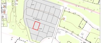
As for the graphic part, initially the layout of the site itself is marked on the plan, a drawing of the separated or attached parts is established, information about cadastral work and initial data is indicated. The plan also shows buildings.
How much does it cost to do this?
In general, in the Russian Federation, land surveying of a summer cottage costs approximately 5 to 10 thousand rubles. A plot for a cottage will cost a little more - from 8 to 15 thousand rubles. The most expensive surveying is intended for commercial purposes. Here, the cost of a land plot plan starts from 15 and reaches 20 thousand rubles. When assessing the cost, the characteristics of the region are always taken into account.
When carrying out land surveying, find out in advance what is included in the cost of the work. If it turns out that the amount is too high, you can demand a reduction in the price of the boundary plan or file a complaint with the organization that established this tariff plan.
Land survey project: requirements and approval
- On the rules for drawing up a map of a land surveying project;
- About the sheet format (A-4);
- On the use of stationery for writing (pencil is not allowed);
- On the use of exclusively Russian language;
- On the rules for numbering sheets and using exclusively Arabic numerals;
A hearing on this issue should be held by a qualified commission, taking into account the audit data received. The basis for approval is the technical requirements and planned characteristics, as well as the general municipal plan drawn up in cartographic form.
Is land surveying necessary if you have a cadastral passport?
But a cadastral passport can be obtained even without carrying out the land surveying procedure. Information about most land plots is contained in the state cadastre and can be entered there without a boundary plan. A cadastral passport is issued upon request. Here you should not confuse the concepts of extract and passport. They contain different information - the extract is more detailed. Therefore, it is impossible to obtain an extract without detailed survey data, unlike a passport. The presence of the second one in no way eliminates the need to carry out the land surveying procedure if it was not previously performed. In addition, the passport will not contain information about the boundaries of the site.
- a geodetic survey is carried out, which helps to accurately establish the coordinate points of the site boundaries;
- You may need an act signed by the owners of neighboring plots stating that they have no claims regarding the established boundaries, since their interests may be affected here;
- the survey results are documented by the expert in the form of a plan and presented to the owner;
- information must be submitted to the relevant authorities.
Land surveying
photo
documentation
sample act of border approval
sample appendix to the act of approving the boundaries of a land plot
sample notice of boundary approval
sample cadastral extract
sample cadastral plan of the territory
Sections of the article:
The word “landmarking” is a derivative of “boundary”. This is a border, boundary, line of division of land plots.
Land surveying is the determination on the ground and legal registration of the boundaries of land holdings. It is part of cadastral activities.
In Russia in the 16th - 17th centuries, the results of land surveying were entered into scribe books, and in the 16th - 19th centuries - into land survey books. Land surveying was carried out by county surveyors. They were prepared at the Land Survey Institute, established in Moscow in 1835.
Large survey works to create the land cadastre of Russia (general survey) were carried out during the Peasant Reform of 1861 and the Stolypin Agrarian Reform. During such work, the productivity of the land, its quality and purpose were determined.
What is the difference between a town planning plan and a cadastral passport?
But still, the validity period of the boundary plan may expire and this happens for one reason. If changes have occurred on your land plot related to an increase or decrease in boundaries, allocation, division or amalgamation, changes must also be made to the boundary plan. Thus, the validity period of the boundary plan ends when you make changes to your land allotment. Parts and sections The boundary plan is a document that has a clear structure established by law. So, the boundary plan itself is divided into two parts. The first contains textual information, the second contains graphic information. These parts, in turn, are divided into sections, which are worth talking about in more detail. The text part is divided into a large number of points that contain basic information about the site. So, in the first paragraph, the initial data about the land plot is indicated.
Conclusion As you may have noticed, drawing up a boundary plan is a lengthy but entertaining process. You yourself will learn something new about your site, for example, information about its boundaries. Today, a boundary plan can be obtained in record time, but ten years ago this procedure would have taken months. But it is better not to delay the procedure for drawing up a land surveying plan.
What is the difference between a cadastral plan and a boundary plan?
A boundary plan is a document - the result of geodetic and land management work of cadastral engineers. The purpose of creation is to secure or establish the boundaries of a plot of land on the ground. It is drawn up on the basis of an act of approval of boundaries and a cadastral extract.
The lack of a boundary plan for the owner becomes an obstacle to obtaining the main document for ownership of a private household with land - a cadastral passport. This, in turn, will make it impossible to register any transactions with this land plot in Rosreestr.
What is land surveying - stages of work
The main purpose of the land surveying procedure is the need to delimit land plots carried out in the process of carrying out cadastral work. The legal basis for surveying is provided by Methodological recommendations for conducting surveying of land management objects, which were approved by Roszemkadastr on February 17, 2003.
The document indicates the need during land surveying:
- establish boundaries when forming a new allotment from the lands of a municipal or state fund;
- to restore the boundaries of the land plot on the ground;
- agree on the boundaries of the land area.
The practical value of land surveying for owners of land plots manifests itself when:
- registration of rights to a site when it is allocated by government agencies;
- dividing one plot into several new ones or, conversely, merging individual plots into a single land mass;
- clarification of boundaries in order to resolve disputes between owners of plots bordering each other.
The process of establishing boundaries between land plots can only be carried out by a cadastral engineer in strict accordance with the established procedure for a phased land surveying process, which consists of:
- collection and analysis of information on the site, as well as on neighboring land plots by studying the documentation provided by the customer, the cadastral plan of the territory or information from the Unified State Register of Real Estate, which requires a current extract;
- drawing up a land surveying project;
- informing owners of neighboring plots about land surveying, whose interests may be infringed in the process of establishing boundaries;
- actions associated with visiting the area, determining boundaries on the land territory and drawing up an act of approval of boundaries;
- geodetic surveys and establishing the coordinates of boundary markers;
- determining the area of land for land surveying;
- execution of a graphic drawing of the allotment indicating the boundaries on a scale, and you also need to draw up a land surveying plan for the property, which is then sent to the appropriate authorities for the purpose of registering the land plot.
For more information about why land surveying is necessary, read our article.
Differences between a cadastral plan and a cadastral passport
The differences between KP and KPL are that KPL is part of KP. Therefore, the CP contains much more information about the land plot, that is, along with information about the location and boundaries of the site, the CP contains information about the owner, area and cost of the land plot, its encumbrance and restrictions, for example, an easement.
Until 2008, the main document issued to the owners of land plots was the cadastral plan (CPL). Since 2008, a cadastral passport (CP) was introduced, which contained a lot of information about land plots. At the same time, the cadastral plan became part of this passport. The basis of this documentation was Law No. 221-FZ of July 24, 2007 “On Cadastral Activities”.