In the process of establishing the boundaries of the plot, the engineer carries out a list of works aimed at accurately calculating the turning points of the plot and determining its boundaries - a contour line that clearly designates the area to which the land owner's property rights will subsequently extend.
As a result, all data is entered into the final document - boundary plan , which is handed over to the customer at the end of the process.
Changes in legislation
The legislation of the Russian Federation periodically undergoes a number of changes, and acts relating to cadastral activities and the conclusion of civil legal acts are no exception.
Thus, starting from January 1, 2021 , an innovation came into force that affected all owners of plots located in the Russian Federation.
Currently, any conclusion of purchase and sale transactions, donations of land, exchange of one plot for other objects and other agreements resulting in the alienation of plots have become impossible without a plan and, as a consequence, without first carrying out the land surveying procedure.
In this regard, the need for drawing up such plans has increased significantly.
In addition, taking into account the required time to draw up a document and carry out mandatory measures, the customer receives a finished plan within a period of 3 to 6 months , so all land owners began to order boundary work, so that, if necessary, they would not waste time collecting the necessary documents and waiting for completion .
In parallel with this, it is worth taking into account the fact that currently registering a land plot requires the provision of a certain list of documentation, among which, in particular, is a boundary plan.
Documents confirming the fact of land surveying: which ones are issued and what they look like
- Initial indicators on the basis of which the engineer made calculations;
- Data on what measurements and calculations were made during the process of drawing up the document;
- Data on what areas or parts of areas were formed or what changes were made to them (if any);
- Data on those plots that allow access to this site;
- Conclusion of the specialist who drew up the plan;
- An approval act signed by all interested parties (owners of adjacent plots).
So, starting from January 1, 2021, any actions with land plots of a civil nature first of all require a procedure for establishing boundaries , as a result of which the owner of the plot receives a boundary plan drawn up by an engineer. Such a plan, in turn, also allows you to submit an application for cadastral registration.
What is a boundary plan
At its core, a boundary plan is a list of information about a site , which is based on an extract from the Unified State Register of Real Estate about the allotment; it also indicates other data that was obtained by the engineer based on calculations and information determined during a direct visit to the location of the allotment.
This document contains the following information :
- A graphic representation of the land plot indicating the turning points, when drawing lines through which the boundaries of the plot are directly formed;
- A list of information required to provide regarding the land plot, defining its main characteristics, owner and parameters that distinguish it from the general mass;
- Data that has been changed in relation to previously established boundaries and boundary plans drawn up before the work was completed.
- Conclusion of the cadastral engineer on the specifics of the work with reference to legislative acts, if necessary;
- An indication of the approval procedure, which confirms that all persons or organizations whose rights could be affected in determining the location of the boundary have approved the location of the boundary.
What to do after land surveying and what the survey document looks like
- general information about cadastral works;
- initial data about the site;
- information about the measurements and calculations performed;
- who is the customer and who is the cadastral engineer;
- what parts does the land plot consist of?
- conclusion of the engineer who carried out the cadastral work;
- an act in which the participants in the survey agree on the location of the boundaries.
If changing the boundaries of the land is the initiative of the owner himself, then, as before, he should carry out the entire land surveying process from beginning to end. That is, resort to the help of a private geodetic company so that its specialists develop a technical plan, travel to the area, mark new changed boundaries, and then prepare a survey file and issue a survey plan.
We recommend reading: Write an application to the court to remove a person from an apartment, sample
Structure and pattern
The structure of the plan is primarily divided into text and graphic parts. The textual one, in turn, is presented directly with information on the land plot, an engineer’s conclusion, and an act of approval of boundaries.
Below we will attach samples and photos of the document so that readers can see what it looks like.
Forms in PDF format can be found here.
Forms in PDF format can be found here.
Text part
The text part contains the main information characteristics of the land plot and includes the following data :
- Initial indicators on the basis of which the engineer made calculations;
- Data on what measurements and calculations were made during the process of drawing up the document;
- Data on what areas or parts of areas were formed or what changes were made to them (if any);
- Data on those plots that allow access to this site;
- Conclusion of the specialist who drew up the plan;
- An approval act signed by all interested parties (owners of adjacent plots).
Conclusion
The conclusion began to be included in the document starting in 2008 as a section of its text part.
Initially, this part of the plan was a special explanation, justification for the work carried out and how the border defining the area of the site runs.
Since 2012, such a part began to be included when necessary and it is drawn up to describe the actions performed.
It is used in situations where the definition of boundaries or any actions in the process of their installation require reference to legislative acts or certain facts to prevent the recognition of boundaries as invalid or illegally established.
Border approval act
Most of the land plots for which the specialist determines the boundaries in the process of drawing up the plan have adjacent plots directly adjacent to it.
In such situations, in order to ensure that the rights of the owners of such plots are not affected, a procedure for their approval becomes necessary.
To do this, a general meeting is held , at which the engineer presents a previously drawn up plan and clearly explains how the boundaries of the site will be drawn.
If there are no contradictions, all interested parties sign a separate document.
If all areas (or some) previously had approvals for passing boundaries, such an act may not be available .
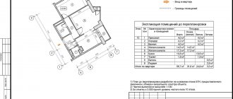
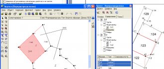
The grafical part
The graphic part of the boundary plan is a direct display of the passing boundaries of the site, defining the boundaries of the property of a person or organization and it contains the following :
- Object diagram;
- Location of the site taking into account the accepted display scales;
- The drawing itself of the site and its parts (if there is a need to highlight the components);
- Outlines of the nodal (turning) points of the allotment, between which there are lines defining the boundaries of the property.
In what formats is it issued?
The plan is presented first on paper . The document is executed in two original copies, one of which is received by the direct customer.
Currently, in parallel, the engineer is also preparing an electronic version , which, if desired, can be separately provided to the customer who has entered into a contract for boundary work.
Structure and content of the boundary plan
The cadastral boundary plan of a land plot consists of text and graphic parts. Each contains several mandatory sections. The paper version is compiled in two copies on A4 sheets (the graphic part can be submitted on larger sheets).
Structure of the text part
The information is presented on several sheets with continuous numbering. Mandatory information on the boundary plan includes:
- the purpose of carrying out cadastral work;
- data from previous surveys, a list of sources and documents used;
- geodetic survey materials;
- information about the site, its individual parts, real estate located on it;
- description of the technology of the work performed, measurement accuracy, coordinates of characteristic points, area, boundaries;
- access to the site;
- act of approval of boundaries;
- conclusion of a cadastral engineer.
Structure of the graphic part
Mandatory subsections of the graphic part of the boundary plan:
- designation scheme for geodetic constructions;
- drawing and layout of the site;
- description of outlines for nodal points.
Important!
The structure and number of mandatory/additional subsections depends on the type of boundary plan.
What to do after the procedure
After surveying and receiving the plan, owners can apply to register their plots and receive (or update) a document confirming ownership.
Collection of documents
The procedure for applying to Rosreestr in one of the possible ways is accompanied by the preliminary collection of the necessary documentation, which includes :
- Applicant's passport;
- Power of attorney, in the event that the application is not from the direct owner, but from an authorized representative;
- A document confirming ownership of the plot;
- The document that became the basis for the emergence of property rights;
- Certificate of approval (if necessary);
- Cadastral passport.
Drawing up an application
To register an allotment, you will first need to draw up an application - it is on its basis that Rosreestr employees will consider the possibility of entering information about the allotment into the general database.
So, the statement states the following :
- The organization to which the application itself is directly sent;
- Document type;
- The number of extracts from the unified register that the applicant will need;
- Information about who is the direct applicant;
- List of documentation that is provided along with the application;
- How does the applicant wish to receive documents;
- The date on which the document was drawn up and the signature of the person submitting it.
Sending to Rosreestr
Submission of the application and the required list of documents is carried out through one of the possible methods - through a personal visit to Rosreestr or MFC, sending an application by mail or sending it via the Internet.
Personal reception
Submitting an application through a personal appointment can be done by directly visiting a Rosreestr branch or any of the branches of the Multifunctional Center.
When submitting documents directly to Rosreestr, the applicant will receive a response to his application as soon as possible .
Thus, registration is carried out within just 5 days, registration of property rights is carried out after 7 days, and joint registration of ownership and registration is completed within 10 days.
Mailing
It is recommended to send an application by mail exclusively by registered mail and in no case send the originals of existing documents in this way - only copies .
However, this method is used only if it is impossible to submit an application in person, since the mandatory period is counted from the moment the letter is received by an employee of the Rosreestr department.
Through the Internet
The method of submitting an application via the Internet is the most convenient, since it does not require personal presence , and the existing system for filling out the application allows you to avoid entering data incorrectly.
To submit documents, you will need to go to the official website of Rosreestr and go to the application submission section, where you fill out all the fields contained therein.
Where in the extract from the Unified State Register does it say about boundary work?
An extract from the Unified State Register, which is provided after the site is registered, is a list of information from two combined databases - the Unified State Register and Cadastral Registration.
Such an extract replaces the provision of a certificate of registration of ownership, a passport of the allotment and a certificate of its price .
The extract includes data contained in three sections:
- Characteristics of the site - exact address, size (area), category of use, number in the cadastre database, as well as other basic parameters;
- Information about the person or organization that is the owner of the site . The presence of any encumbrances that exist regarding actions with the site (for example, if it is collateral), data on the seizure or emergence of the right to own it are indicated;
- The grafical part . It directly displays a diagram showing the delineation of the allotment, that is, an indication of how its border directly passes. The address of the site is also indicated and the route of utilities is stated.
Land surveying according to the new law
Rosreestr has entered into agreements with 13 regions, which received subsidies from the federal budget for the implementation of complex cadastral work within the framework of the Federal Target Program (FTP) “Development of a unified state system for registration of rights and cadastral registration of real estate (2014 - 2021).”
First of all, the land documents must indicate its cadastral number; these rules were also spelled out in the law on land surveying before 2021. If the documents were issued a long time ago and do not contain a cadastral number, then the owner applies with these documents to the MFC or Rosreestr. In this case, it is necessary to register the site with primary cadastral registration. It's free - the owner will need a passport and a certificate of ownership. If the owner cannot do this himself, a power of attorney, certified by a notary, is drawn up to carry out a set of cadastral works to register the land plot.
We recommend reading: Selling an apartment with a Sberbank mortgage