Reasons for not having established boundaries
There are several reasons why land surveying was not carried out on the site. This procedure involves establishing boundaries on the plan and on the ground, creating a boundary file, which will include a description of the land plot and its drawing. After which all survey results are included in the state cadastre database .
The demarcated plot will be registered in the cadastral register and can be found on the public cadastral map. If you look closely, you can see that there are areas on it that do not have coordinates. This means that the owner of the plot did not carry out land surveying, although the plot has a cadastral number and an owner.
Land surveying was not carried out for the following categories of citizens:
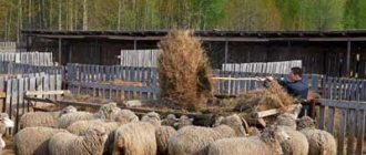
- Summer residents . There are still dacha plots whose owners prefer not to carry out this procedure. Most often this is explained by high prices for ]cadastral engineers[/anchor]. Sometimes problems arise due to unauthorized “cuts”, when part of the land in use is not documented in any way. But, in general, the dacha amnesty allows you to register a dacha plot using a simplified system.
- Persons whose rights to plots arose on the basis of perpetual use . The peculiarities of such ownership are the absence of the right of transfer by inheritance, donation and sale of land. Such a site can be registered using a simplified system, but land surveying will allow more precise boundaries to be drawn.
- Citizens who bought a plot without land surveying. Most likely, the previous owners registered the allotment in the same way, taking advantage of the law on dacha amnesty.
The following reasons are also possible:
- The site has been allocated by the local administration for some program (for example, assistance to large families). Here land surveying is a matter of time. Typically, new owners try to obtain all documents for registering property rights as soon as possible.
- The site may not be on the cadastral map due to the fact that the documents were not submitted to the state cadastre . The land surveying procedure was carried out in full.
In these cases, it is enough to contact Rosreestr with documentation or carry out the survey again.
There are plots whose market value practically does not exceed the costs of land surveying and registration of the plot. In this case, the owners prefer not to register the land.
The need for land surveying until 2021
Previously, fixing the boundaries of a land plot was not mandatory and was carried out only at the request of the owner, in particular, when registering ownership rights or when taking actions with the land aimed at its alienation.
At the moment, according to Federal Law No. 447, land surveying is considered a necessary procedure for all land owners, and it must be completed by the end of 2021. Regarding what will happen if land surveying is not done before 2018, the law provides clear explanations. In this case, citizens will lose the opportunity to conduct the following legal transactions with land:
- sale;
- donation;
- exchange;
- inheritance;
- rental use.
In other words, if the owner of a land plot does not take care in a timely manner to carry out work to determine the boundaries of the territory and subsequently register them in the cadastre, he will completely lose the right to dispose of the property at his own discretion.
Against the backdrop of information about the mandatory determination and registration of land boundaries, citizens often have a question: is it possible to carry out land surveying after 2021? It is worth clarifying here that this is possible even after this, but applies to those cases when no emergency transactions with property are expected in the coming years or such are excluded altogether.
If the owner has a plan to sell the plot, include it in a will, exchange it, or another transaction with land is contemplated, care should be taken to register the boundaries before the deadline specified in the legislation. In addition, from this moment on, fixed prices for the procedure will not be regulated, which means the price of the issue will change significantly.
Is it possible to register land as a property without land surveying?
Land registration involves several stages :
- submission of all documents to Rosreestr;
- writing an application;
- payment of state duty.
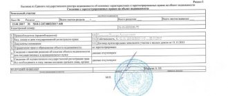
The presence of a boundary plan or cadastral passport will make the registration complete . That is, all information about the site, the coordinates of its boundaries and the boundary plan will be in the Rosreestr database. When selling a plot, the buyer will know exactly its characteristics.
How to register a plot of land for cadastral registration
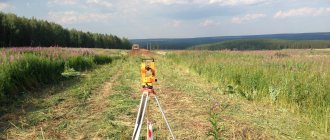
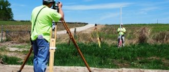
In order to register a plot of land for cadastral registration, you need to provide a package of documents to the state cadastre department at Rosreestr. Cadastral registration is the entry of information about any property, including land plots. To collect this information, a specialist must go to the site .
The cadastral engineer determines the coordinates of the land boundaries and registers all the information received in acts and other documents that are submitted to Rosreestr. Then the documents are processed and the plot acquires a cadastral number. And all other data is entered into the database.
Read more about cadastral registration here.
How to get a cadastral number
The presence of a cadastral number indicates that the land plot is registered in the cadastral register . All documents relating to this site have a cadastral number. With it, any property can be identified faster and easier, since it is not repeated anywhere.
A unique cadastral number can now be obtained not only after the land surveying procedure. Read more about obtaining a cadastral number here.
But there are exceptions. There are a small number of sites left that are registered in various information systems.
But at the same time, the citizens who are the owners of this land have not officially registered their ownership. We are talking about plots with the right of permanent, unlimited use.
The issuance of a cadastral passport for a land plot was possible without land surveying. In this case, the document contained a note that “the boundaries were not established in accordance with the requirements of the law.”
Obtaining a certificate of ownership
A certificate of ownership of a land plot could be obtained without land surveying.
Owners often have a question: do they need to do it now if they already have a document?
Using the services of a cadastral engineer and determining the coordinates of the boundaries of a plot is sometimes forced by the wishes of the buyer, who wants to know exactly what he is buying.
Rosreestr stopped issuing Certificates printed on stamp paper in 2021.
Now an extract from the Unified State Register serves as a document confirming ownership. It is printed on plain paper, A4 size.
Now Certificates are not issued, and acquisition of property rights is impossible without land surveying . This means that it will not be possible to bypass this procedure when purchasing a plot.
The procedure for carrying out land surveying
Package of documents and deadlines
For legal entities and private entrepreneurs
You should know that the absence of a document is not a reason to refuse to carry out land surveying.
The maximum period for completing a land surveying project is 2 months. Otherwise, the processing time is determined by regional legislation:
- Within the city, the entire land surveying procedure takes on average 10-15 working days.
- In municipalities – up to 30 days.
Should I tell my neighbors?
Before carrying out the land surveying procedure, all actions must be coordinated with the neighbors. It is best to send them a registered letter with notification so that you have proof in hand. During the procedure, neighbors act as witnesses, and the specialist enters their passport data into the work report. This way they confirm that they have no complaints about the land surveying procedure. If the land plot is located in a garden or dacha partnership, the written consent of the head of the Board will be required.
If a controversial situation arises during the procedure, the claims must be documented and resolved in court. We will have to look up the history of the site from the moment it was allocated and, based on this data, file a claim.
What is the procedure for land surveying?
It was previously mentioned that land surveying is carried out in accordance with instructions from 1996 and is divided into several stages:
- Collecting a package of documents, concluding an agreement with a company or individual who will conduct land surveying.
- Drawing up a plan for boundary work. This is done by a specialist; this stage includes creating a project, working with neighbors, conducting geodetic measurements, and establishing the area of the land plot. A survey is carried out, boundaries are clarified, a topographic plan is prepared, boundaries are marked (signs are installed).
- Issuance of documents to the owner of the site.
When to carry out surveying
It is recommended to carry out land surveying in the following cases:
- Identifying the boundaries of a plot when distributing land: for example, the land needs to be divided into 2 families.
- A dispute with neighbors arises – it is not uncommon for neighbors to occupy part of your plot, and you don’t even know about it.
- Determination of the market value of land.
- Registration of the site for cadastral registration.
- Preparing property for transactions (exchange, purchase and sale, donation, etc.).
- Registration of property rights (inheritance, acquisition).
It is important to know that without land surveying it is impossible to register a new property or sell, donate, or take ownership of the site. This is a complex procedure that should only be performed by a specialist. Requires additional financial costs.
The land surveying process is regulated by the Land Code of the Russian Federation, Law No. 78 “On Land Management” and is carried out in accordance with instructions dated April 8, 1996. Also, the specifics of the procedure may be prescribed in the Town Planning Code and acts of local importance.
Important! Only design organizations or persons licensed to carry out this type of work can carry out land surveying.
Where to contact:
- To the design and survey departments of Rosnedvizhimost.
- In companies engaged in geodetic research and cartography.
Don’t be lazy and check whether the company has a license to conduct land surveying. It is important that the staff has a surveyor, land surveyor, and topographer - then the work will be completed with high quality and on time. If the boundary plan is drawn up incorrectly, the cadastral commission will simply return it, and the customer will lose time and money. Also on the Rosreestr website in the “Cadastral Engineers” section, you can select a specialist from the list. Reviews of his activities are also presented there.