- Land surveying in the MFC
- Why undergo the procedure?
- How are land boundaries established? First stage: signing the contract
- Second stage: performing land surveying
- Third stage: issuing a survey plan to the customer
- Stage four: entering data into the state cadastre
- Fifth stage: registration of property rights
Obtaining a passport at 14 years old through the MFC
Registration of a mortgage at the MFC - necessary documents
The procedure for establishing clear boundaries of a land plot and their approval is land surveying. All owners (over 30 million) of land plots were required to undergo it by the end of 2017 in accordance with Federal Law No. 447. One of its articles establishes the fact that it is impossible to dispose of your own land starting from 2021 without legitimizing your rights as an owner and obtaining new documents. The establishment of the owner's rights is limited to land surveying. In January 2021, Parliament issued a strict ban on the disposal of property that has not been demarcated, and also approved Federal Law No. 218, which allows the mandatory procedure to be completed by the end of 2018. What is this procedure? Why was it introduced? How is it carried out?
Agreement
Cadastral engineers have the right to carry out land surveying. This activity is licensed, so they must have a document confirming the right to perform this work. You need to make sure that the document is available, then conclude an agreement on the basis of which the work will be carried out.
A preliminary consultation will be required; many companies do not charge a fee for it. It is carried out to clarify the list of works, since in each specific situation it may differ. If individual documents are missing, they will tell you which of them and where you can obtain them.
The text of the contract specifies all the conditions:
- list of works;
- geodetic services;
- price, advance payment, method of payment;
- deadline;
- rights, responsibility.
The duration of surveying is usually 2–3 weeks.
Documentation
Before contacting a geodetic company, you must collect documents and certificates. These include:
- passport of the owner of the site;
- title document to confirm ownership;
- certificate of absence of electrical cables;
- certificate that there are no public communications.
Cost of surveying
The final price depends on several factors. It is included in the contract after the specialist has clarified all the details. Of significant importance are:
- remoteness of the area where the object is located;
- land area;
- category of land;
- complexity of the work, its volume;
- additional services, including technical plans for buildings.
The responsibilities of the engineer include:
- checking documentation;
- measurement of the site;
- drawing up a plan and writing a conclusion.
Planning
The rights of owners of neighboring plots should not be violated. The law obliges the owner to notify the owners of adjacent plots about the date of land surveying. This simplifies approvals and minimizes the risk of disputes over boundaries. The owner himself can notify the neighbors. To do this, a notice is written indicating the time of land surveying, on which the neighbors sign. If they refused to attend, this will not prevent the work from being carried out.
If adjacent plots have already gone through this procedure, the owners have a certificate, and there is no need to notify neighbors. The surveyor’s task is to conduct surveys on the ground, finding out the exact coordinates of the points where the direction of the site boundary changes. There is special equipment for this; GPS devices are used to determine coordinates using satellite communications.
Using the data obtained, the engineer draws up a boundary plan. Sometimes you have to request information from the cadastral authorities about the boundaries of neighboring plots. The final stage is when the parties sign an agreement on boundaries. It is signed by the neighbors, the customer and the municipality employee.
Compliance with the requirements prescribed by law and notification of neighbors does not guarantee the absence of claims. If you cannot reach an agreement on the spot, you will have to go to court. He orders an examination, and a decision is made after receiving its results. The land survey plan is made on paper and electronically for Rosreestr. It consists of a description and an image and contains all the information about the site.
How to register land
It is possible to submit documents through the MFC in order to immediately register the plot and register your ownership. You shouldn’t put it off until later, the form of the document may change, and you’ll have to do it all over again. The MFC has special application forms that must be filled out to provide the service.
The law stipulates that land surveying through the MFC must take place within 10 days, the period begins from the time when the Cadastral Chamber received the collected documents. If registration occurs through the MFC, then the period increases, which is due to the peculiarities of interdepartmental document flow. The employee receiving the documents issues a receipt and sets a date for the visit.
Demarcation of the boundaries of a plot of land is necessary to mark its boundaries, enter information into cadastral registration, and determine the market price. It is mandatory when connecting the site to utilities. A plot of land that has cadastral boundaries can be donated, sold or bequeathed.
Submission of documents to obtain a cadastral passport
The boundary plan on electronic media must be submitted to the branch of the Federal Service for State Registration, Cadastre and Cartography for cadastral registration.
Registration is carried out free of charge within 10 working days. There should be no delay in submitting an application for registration: this must be done as soon as possible after receiving the boundary plan. This is due to the fact that the form of the boundary plan changes quite often (several times a year).
By submitting an outdated boundary plan to the Cadastral Chamber, you will be denied registration. You will have to contact the land management company again so that the form of the boundary plan is brought in accordance with current legislation.
To get an appointment at the Cadastral Chamber, you need to take a coupon (in the institution’s electronic terminal or through the website).
After 10 working days from the date of filing the application, the Cadastral Chamber will issue a cadastral passport of the land plot, which contains all the basic characteristics of the plot, its cadastral number and cadastral value.
Why submit documents to the MFC after land surveying?
When concluding a survey agreement, we recommend that you first consult with our specialist from. A preliminary consultation with our company is free, but it will help you determine the list of necessary work, since each situation is individual. If you have not yet collected documents, our specialist will tell you during your consultation what documentation is required for land surveying and where you can get it. The contract states:
- Types of geodetic and cadastral work we perform.
- Cost and payment options for services (cash or non-cash payment, prepayment amount - 50%).
- Terms of execution of the contract, as well as liability for their violation.
Why submit documents to the MFC after land surveying?
People mistakenly think that the MFC operates in a one-window mode. No, that's not true. You can submit a number of documents to the MFC, on the basis of which ownership rights will be registered or issued.
This is interesting: Temporary status of a land plot
And the hardest thing is when they give you a suspension, then with this suspension you go directly to a place other than the MFC (because at the MFC they throw up their hands and say: “It’s not us... we’re just intermediaries. We brought it, gave it back and that’s it. The order and procedure for carrying out land surveying plot of land His task is to survey and determine the coordinates of turning points.
Land surveying through MFC: principle of implementation and features
The duration of the land surveying procedure depends on various factors, but on average this period ranges from two to three weeks.
- Rights and responsibilities of the parties.
How much will surveying cost? The land surveying procedure is paid; the price of the service is influenced by various factors:
- Site location.
- Its area.
- Land category.
- Type, volume and complexity of the work performed.
- The need to perform other work (for example, drawing up a technical plan for buildings).
- Additional services.
Our specialist will calculate the final cost after clarifying all the factors. This amount is included in the contract.
The order and procedure for land surveying
The multifunctional center acts as an intermediary between the Companies House and the owner. Cadastral registration in the MFC If you need to draw up not an old certificate, but, for example, a cadastral extract as a result of land surveying, then you come to the MFC with a disk with the survey file that the cadastral engineer recorded for you. You take a coupon, but you already take the coupon for cadastral registration. When your number lights up on the board, you also go to this window. In this window, you hand over the disk with the survey file to the MFC specialist, and you also show your passport, since when clarifying a land plot, only the owner or a person with a power of attorney should apply. Other people do not have the right to come for you and hand over the survey disc. The same applies to discs with a technical plan.
Owners of plots can take advantage of free services as part of complex cadastral work. They cover cadastral blocks (large areas).
If an individual plot of land falls into one of them, then the owner of the land or garden plot can use land surveying services for free. This opportunity is provided for by the federal program, but landowners need to meet the deadline from 2018 to 2021.
It was developed to reduce the number of unregistered plots. During the events, the landowner receives new official papers for the property. As soon as the program expires, free land surveying will be available only during the procedure for purchasing or leasing a plot from the municipality (participation in an auction). Subsequent cadastral registration of a property requires an application to the MFC.
Registration price
MFC provides all services completely free of charge. The law does not provide for state duties for land surveying. Requirements to pay for priority consideration of applications, advancement in queue, etc. are illegal. Land surveying itself as part of the implementation of a comprehensive cadastral work program is carried out at the expense of the budget. These costs cannot be passed on to land users.
The customer can enter into a contract for cadastral work with a private company. In this case, he will have to pay the cost of such services at his own rates.
Land surveying: what document is drawn up based on the results?
Let's look at the most common cases and purposes for which land surveying was carried out. When you have a land survey plan in your hands, all possible actions depend on the goals that this procedure pursued when you determined the boundaries of the site. At its core, there are three main options: - obtaining information about your site when you just wanted to see where the boundaries of your property officially end; — land surveying to register the site in the state real estate cadastre; - going to court in case of land disputes and conducting a land forensic examination. If with the first and last case everything is very clear - the documents are transferred to your lawyer or to the court directly, or simply the boundary plan will be placed in a folder with documents, then in the second option with registration on accounting in the State Tax Committee everything is somewhat more complicated. Based on its results, a cadastral passport is issued in the name of the owner. It takes into account the features of the object, its price and number. Fifth stage: registration of property rights To register, contact the MFC. The owner provides the employee with:
- passport;
- receipt of payment of state duty;
- statement;
- cadastral passport;
- SNILS;
- papers for land plot.
Over the next 10 days after submitting the papers, data about the object will be entered into the Unified State Register. As a result of this operation, the owner receives a certificate of state registration of rights, making him the sole owner of the property.
How to obtain a copy of the boundary plan of a land plot in the Rosreestr
How long can I receive copies of documents on the basis of which information about a property is entered into the state real estate cadastre? The deadline for providing information is no more than 5 working days from the date of receipt of the relevant request by the Cadastral Chamber.
The legislation does not limit owners' property rights , in accordance with Article 35 of the Constitution of the Russian Federation and Chapter 17 of the Civil Code. This rule created a precedent for the presence of undemarcated plots put up for auction in large quantities.
We recommend reading: Procedure for seizure of land for state needs
Why submit documents to the MFC after land surveying?
All measurements are carried out using geodetic equipment. The survey is carried out using GPS devices, and coordinates are determined via satellite. Then, based on this information, the cadastral engineer will prepare a boundary plan. If necessary, he can request additional information from the cadastre authorities about neighboring areas. An obligatory step is the signing of the border approval act. This document confirms that your neighbors have no complaints and agree with the established boundaries. The act is signed by the customer, neighbors and a representative of the municipality. There is no need to draw up an act of consent if the neighboring plots were demarcated earlier. Is it possible to survey a plot of land for free? What to do after surveying a land plot Having surveyed their land plot, many landowners are wondering what to do after. Additional information on the allotment is clarified by the engineer independently in the State Property Committee, Unified State Register Third stage: issuance of a land survey plan to the customer. The result of the activities carried out by specialists is the provision of a land survey plan to the landowner. It should have two parts - graphic and text, reflecting:
- results of measurements on the ground;
- data for entering into the cadastre;
- acts of resolution and coordination of controversial issues.
Fourth stage: entering data into the state cadastre To register the plot of land, the owner provides a passport with an application (filled out according to the sample) and a cadastral plan in two parts (digital on a flash drive and separately on paper).
If the procedure is carried out by an authorized person, they must present a document confirming their authority - a power of attorney. Registration will take 10 days. It is free of charge.
Also, the lawyer of the State Property Committee Nedcadastre recommends obtaining in advance a new decree from the archive, an archival copy of the decree for the allocation of this land plot. Take my word for it, this is necessary. Next, you need to take a coupon for state registration. When you receive your ticket, there is a number on the ticket. You will be asked to go into the hall where there is a board with a list of numbers. The selected number is accompanied by an office number or a window where the person with the owner of this number is waiting. When your number comes up, you go to a certain window, to a specialist, and say that you need to get a new certificate to replace the old one. And an application for a new certificate is filed. The application is filed by a specialist, the owner does nothing. The only thing that needs to be noted is that the owner provides the original document, which is transferred to the MFC.
How are land boundaries established?
The engineer provides the service in accordance with the requirements of the Land Survey Instructions (issued in 1996). It stipulates the sequence of work, the conditions for its implementation, standards for monitoring the accuracy of the installation of signs, as well as the principles for drawing up acts upon completion of work. The document applies to legal entities and individuals and describes in detail the stages of cadastral activities.
First stage: signing the contract
The document describes the relationship between the applicant and the organization providing cadastral services. The landowner can resort to the help of engineers registered with the municipality (contacts will be provided by an MFC employee), or to private organizations. In the second case, cadastral work will have to be paid for. They are carried out by two or more engineers who have received certificates of appropriate qualifications.
Second stage: performing land surveying
To start the process, the cadastral engineer needs to present a mandatory package of papers and indicate the plot of land in the area. The presence of neighbors will also be required to coordinate its boundaries. List of required documents to present:
- papers for an allotment of land: certificate of inheritance, deed of donation, deed of sale or other;
- technical documentation: papers from the BTI, cadastral passport and others;
- identification document of the owner of the plot: passport for an individual and constituent papers for a legal entity.
To prevent the procedure from being delayed, the list of papers to be submitted to the cadastral engineer must first be clarified with a specialist or with the organization with which the contract was signed. Additional information on the allotment is clarified by the engineer independently in the State Property Committee, Unified State Register
Third stage: issuing a survey plan to the customer
The result of the activities carried out by specialists is the provision of a boundary plan to the landowner. It should have two parts - graphic and text, reflecting:
- results of measurements on the ground;
- data for entering into the cadastre;
- acts of resolution and coordination of controversial issues.
Stage four: entering data into the state cadastre
To register the plot of land, the owner provides a passport with an application (filled out according to the sample) and a cadastral plan in two parts (digital on a flash drive and separately on paper). If the procedure is carried out by an authorized person, they must present a document confirming their authority - a power of attorney. Registration will take 10 days. It is free of charge. Based on its results, a cadastral passport is issued in the name of the owner. It takes into account the features of the object, its price and number.
Fifth stage: registration of property rights
To register, contact the MFC. The owner provides the employee with:
- passport;
- receipt of payment of state duty;
- statement;
- cadastral passport;
- SNILS;
- papers for land plot.
Over the next 10 days after submitting the papers, data about the object will be entered into the Unified State Register. As a result of this operation, the owner receives a certificate of state registration of rights, making him the sole owner of the property. This completes the procedure.
What is the price and validity period of the land boundary plan?
Brief instructions for land surveying:
- Collection of all necessary documents.
- Concluding an agreement with a surveying organization to carry out the procedure.
- Providing a boundary plan.
- Obtaining a cadastral passport.
- State registration of property and payment of fees.
Let's take a closer look. Before you begin land surveying, you need to collect the following documents:
- Documents for land certifying the right to own it.
- Passport of a citizen of the Russian Federation and its copy.
- SNILS.
- If it is not the owner who is in charge of registering the land, then a notarized power of attorney on behalf of the copyright holder is required.
Deadline for submitting a land survey plan to the MFC from the date of production
Below is a list of additional services and average prices for them:
- notification of owners of neighboring plots about upcoming land surveying - from 150 to 350 rubles;
- complete execution of all papers - from 3,000 to 5,000 rubles;
- Almost all companies offer land redistribution services. During redistribution, a number of works are carried out aimed at changing the boundaries of the site. The cost of such services varies from 11 to 15 thousand rubles.
Reference: land redistribution is the creation of a new plot with a larger or smaller area.
The entire manufacturing procedure will cost an average of 15 thousand rubles, it all depends on the performing organization you contact. Additional services cannot be mandatory, it all depends on your budget and desire. For example, they receive hunting tickets, weapons permits, replace and exchange passports, or receive a foreign passport, etc... - Over time, will the Registration Chamber be closed for ordinary people and all documents will be done only through the MFC? No. Companies House will never be closed. They will close it for ordinary people, but the registration chamber will not be closed in general. She will continue to perform her functions, and the MFC will collect documents. “My Documents” only performs the function of an intermediary, which means that the idea of the MFC is also to fight corruption, i.e. access to government officials has become significantly more difficult. “My Documents” are opened in every region of the Russian Federation and at the same time, none of the other bodies, the Cadastral Chamber, the Registration Chamber, the Architectural Chamber, etc., have been reduced. It turns out that the MFC has been supplemented by the main state ones. services, and there are more jobs. If you contact a private cadastral engineer, he can set prices at his own discretion, but they should not exceed the maximum threshold established by law. What is the price and validity period of the land boundary plan? Attention To receive a government service, you must fill out the application presented on the website, then the system (after verification) will send all the data to Rosreestr. To track the status of your application, you must view your Personal Account.
Providing documents to Rosreestr for cadastral registration and registration of property rights
The choice of contractor largely determines the quality of the work performed.
Federal Law No. 221-FZ of July 24, 2007 “On the State Real Estate Cadastre” assigns the right to perform cadastral work exclusively to specialists who have a valid certificate confirming the qualifications of a cadastral engineer.
Such specialists can work individually or be employees of large companies, but information about them can be found in the registers of self-regulatory organizations and on the official website of Rosreestr in the register of cadastral engineers.
To perform cadastral work, you must first conclude a contract. The contract should list the work that the specialist will perform. The estimate and assignment for the work, approved by the customer, must become appendices to the agreement.
Recommendations from friends or a specialist’s portfolio help you choose a contractor.
Sample application
To the Committee on Land Resources and
land management of the city of Krasnokamsk
From Ivanov Ilya Olegovich passport 4202 452623,
issued 04/12/2004
Registered in Krasnokamsk,
st. Zelena, 14, apt. 5
STATEMENT
I ask you to carry out surveying of the land plot located at the address Novy, Svetlaya St., 8. The plot belongs to me on the basis of certificate No. 38 dated February 18, 2017. Cadastral number of the land plot is 23:05:0602009:1622. I agree to pay the costs of land surveying in the amount of 10,000 rubles.
__________________________
(signature, date)
For various reasons, the owner may not participate in the procedure for determining boundaries, their approval and clarification of cadastre data. In this case, it is possible to transfer the right to perform actions on behalf of the owner of the organization or to an authorized person.
The power of attorney must include the following information:
- date of registration;
- personal data of the applicant;
- personal data of the authorized person (full name, passport);
- in which organizations and on what issues the authorized representative can represent the interests of the applicant;
- data of the property in respect of which cadastral work will be carried out;
- date of validity of the power of attorney;
- applicant's signature.
Work to determine the boundaries of land plots can be divided into three stages:
- Preparatory
- Field
- Documentary
At the first stage, information about the study area is collected.
Specialists study an extract from the cadastre of real estate, a cadastral plan of the territory, maps, inventory results, information about the owners of adjacent plots and organizations that provide public utilities and energy supplies.
The second stage of work is carried out on the site and adjacent areas. Interested parties are notified about the cadastral work, a sketch of the plot diagram is drawn, boundaries are determined using special tools and boundaries are agreed upon with the owners of adjacent plots.
The third stage is the final one. Documentation of the work carried out, calculation of the area of the land plot, reflection of the boundaries in the boundary plan, preparation of the survey file.
How it happens
For the customer, the land surveying procedure looks simple:
- a geodetic survey of the described land plot is carried out;
- the cadastral engineer determines the boundary points and coordinates them with the neighbors (Article 39-40 of the Federal Law No. 221 of July 24, 2007);
- on the day specified by the contractor, it is necessary to pick up the finished boundary plan from the contractor;
- the boundary plan should be approved by the Land Resources Committee;
- register a plot with certain boundaries for cadastral registration;
- register changes in Rosreestr.
Procedure
The procedure and list of work carried out within the framework of land management are contained in Government Decree No. 396 of 06/07/2002.
- First of all, it is necessary to select the performer of the planned events;
- Prepare existing documents for the site and the right to own it;
- Prepare the area by marking 30-50 cm conditional boundaries with pegs;
- Call the contractor and agree on a departure time to shoot the site. The owner may be present;
- A team of surveyors leaves to carry out geodetic measurements;
- At a general meeting or in an individual conversation with each owner of an adjacent plot, the established boundaries are agreed upon, after which the “Boundary Approval Act” is signed;
- The cadastral engineer puts the date and installation number on the boundary signs.
Within a month after the shooting, the performer prepares documentation. Then he gives the customer a boundary plan.
The same contractor can register property rights in the cadastral register if the customer does not want or cannot do this on his own.
Price
The Cadastre Law gives regional authorities the right to set maximum prices for cadastral works.
Organizations providing such work independently determine their cost.
On average, depending on the region, the cost of preparing a boundary plan ranges from 4,000 to 10,000 rubles.
We invite you to familiarize yourself with: Land surveying
The timing of the 3-stage work depends on the workload of the contractor, the accessibility of the site and the complexity of the landscape.
Offers may vary significantly - from 10 days to 1 month.
To complete the procedure for registering ownership of the surveyed plot, it will be necessary to prepare and submit a package of documents to the cadastral registration authorities. On the list:
- boundary plan;
- title documents;
- the applicant's identity card;
- application for registration.
The same organization that carried out the land surveying work can register property rights in the cadastral register, if the customer does not want or cannot do this on their own.
Carrying out the land surveying procedure allows the owner of a land plot to dispose of property at his own discretion, be confident in its integrity and control the accrual of land tax, knowing the cadastral value of his property.
Cadastral registration is also of interest to the state, since it allows you to organize information about land management and make land circulation accessible and understandable.
Deadline for submitting a land survey plan to the MFC from the date of production
As a result of the finished new certificate, this document is returned back. You must have your passport with you, as well as all other documents, the original decree or a certified archival copy. This is all handed out the window. The specialist at the window issues a receipt.
- a plot of up to 0.5 hectares will cost 10,000 rubles;
- a plot of 0.5 hectares will cost 10,000 rubles + 3,000 rubles for subsequent hectares;
- 10 or more points on the site will cost 200 rubles for each subsequent one.
Establishment of site boundaries by coordinates in populated areas:
- 5 points will cost 1,000 rubles each;
- more than 5, but no more than 15 points will cost 1,500 rubles and 700 rubles for each subsequent one;
- exceeding 15 points will cost 4,500 rubles and 500 rubles for each subsequent one.
What will you have to pay extra for? Despite the fact that the state is trying to regulate the cost of private engineers and surveying companies, many violate these standards. Violation occurs through workarounds, or to be more precise, additional services. Registration of a cadastral passport is carried out only in Rosreestr, or rather in its territorial bodies. You don't need to go to BTI. Content:
- Land surveying: step-by-step instructions
- What is the deadline for registering a land plot with cadastral registration?
- How long does it take to produce a cadastral passport at the MFC?
- What is the price and validity period of the land boundary plan?
- Is it possible to survey a plot of land for free?
- Algorithm for obtaining a cadastral plan of a land plot
- How to properly submit a boundary survey to the MFC
- Deadline for submitting a land survey plan to the MFC from the date of production
Land surveying: step-by-step instructions As a result of the completed new certificate, this document is returned. Important This is all handed over to the window. The specialist at the window issues a receipt.
Refusal to register for cadastral registration means the impossibility of carrying out the procedure. In this case, the citizen becomes the owner of the property, but does not have ownership rights, since the land is not registered in the cadastral register. The law stipulates that the owner of the land is the one who registers it. In this case, the inherited property is not the property of the heir. That is why registration will be carried out on behalf of the heir, who at the time of application is not yet the owner, but has full right to undergo the procedure. Another situation is when a citizen wants to buy a plot of land from the municipal authorities. According to the law, he has nothing to do with real estate in order to draw up cadastral registration papers.
This definition is enshrined in paragraph 1 of Article 22 of the Federal Law of July 13, 2015 No. 218-FZ “On State Registration of Real Estate”. It should be immediately noted that neither the specified Law, nor any of the currently valid by-laws contain any restrictions on the validity period (relevance) of the boundary plan. However, it must be taken into account that cadastral registration is carried out only on the basis of a boundary plan that meets the requirements of current regulations, and changes are made to the Real Estate Registration Law, as well as other regulations, quite often. Currently, the form and requirements for the preparation of the boundary plan are established by Order of the Ministry of Economic Development of Russia dated December 8, 2015 No. 921 “On approval of the form and composition of information on the boundary plan, and requirements for its preparation” (Order No. 921).
Appendix 3.1. Statement
Appendix 3.1 To the committee on land resources and land management of the district (city) From (last name, first name, patronymic of the citizen or name of the legal entity) (passport details of the citizen or details of the legal entity) Address I request you to carry out surveying of the land plot (owned, possessed, used) Document of title (state deed, certificate, agreement, etc.) (number, date of issue, by whom issued) Cadastral number of the land plot: I agree to pay the costs of surveying the land plot.* ________________ * The applicant pays the costs of surveying the land, with the exception of work to establish , securing and geodetic reference of supporting boundary marks. (applicant’s signature, date) “ “ 199| Appendix 3.2 APPROVED Chairman of the Committee on Land Resources and Land Management | |||||||||||||||||||||||
| M.P. | (district, city, region) | ||||||||||||||||||||||
| (signature, surname, initials) | |||||||||||||||||||||||
| « | « | 199 | G. | ||||||||||||||||||||
| TECHNICAL SPECIFICATIONS FOR LAND MARKING | |||||||||||||||||||||||
| 1. Land plot N | |||||||||||||||||||||||
| 2. Location of the land plot | |||||||||||||||||||||||
| 3. Name and address of owner, owner, user | |||||||||||||||||||||||
| land plot | |||||||||||||||||||||||
| 4. Name and address of the performer | |||||||||||||||||||||||
| 5. The technical design for boundary work has been approved | |||||||||||||||||||||||
| 6. The preliminary estimated cost of the work is | |||||||||||||||||||||||
| 7. Information on the availability of materials from previously completed surveys | |||||||||||||||||||||||
| 8. Types and volumes of work to be performed | |||||||||||||||||||||||
| 9. Requirements for accuracy of work | |||||||||||||||||||||||
| 10. Coordinate system | |||||||||||||||||||||||
| 11. Special and additional requirements for work performance and reporting | |||||||||||||||||||||||
| materials | |||||||||||||||||||||||
| 12. Deadlines and procedure for submitting reporting materials | |||||||||||||||||||||||
| 13. Applications: | |||||||||||||||||||||||
| Manufacturer: | |||||||||||||||||||||||
| (job title) | (signature) | (surname and initials) | |||||||||||||||||||||
| « | « | 199 | G. | ||||||||||||||||||||
We invite you to familiarize yourself with: Temporary manager at the supervision stage in case of bankruptcy of a legal entity: rights, obligations, action plan
| Appendix 3.3 | ||||||||||||||||||
| To whom (surname and initials of the owner, possessor, user of the land plot or head of the legal entity) I ask you to come in person or send your representative to | ||||||||||||||||||
| hours " | « | 199 | at the address: | |||||||||||||||
| to participate in establishing and agreeing in kind on boundaries | ||||||||||||||||||
| land plot | ||||||||||||||||||
| (name, surname and initials of the owner, | ||||||||||||||||||
| owner, user, cadastral number of the land plot) | ||||||||||||||||||
| district | ||||||||||||||||||
| (Name) | (name of the republic within the Russian Federation, | |||||||||||||||||
| edge, region, autonomous entity) The appearance of you or your representative with a power of attorney confirming his authority to participate in establishing boundaries and sign the relevant documents is required. Land surveyor engineer: | ||||||||||||||||||
| (name of design organization) | (signature) | (surname, initials) | ||||||||||||||||
| « | « | 199 | G. | |||||||||||||||
| Appendix 3.4 | |||||||||||||||||||||
| RECEIPT | |||||||||||||||||||||
| Notice | |||||||||||||||||||||
| (specify to whom) | |||||||||||||||||||||
| about calling a representative to | hours " | « | 199 | G. | |||||||||||||||||
| to participate in establishing and agreeing in kind on boundaries | |||||||||||||||||||||
| land plot | |||||||||||||||||||||
| (name, surname and initials of the owner, | |||||||||||||||||||||
| owner, user, cadastral number of the land plot) | |||||||||||||||||||||
| district | |||||||||||||||||||||
| (Name) | (name of the republic within the Russian Federation, | ||||||||||||||||||||
| edge, region, autonomous entity) | |||||||||||||||||||||
| received " | « | 199 | G. | ||||||||||||||||||
| (job title) | (signature) | (surname and initials) | |||||||||||||||||||
| The notice was handed over by " | « | 199 | G. | ||||||||||||||||||
| (job title) | (signature) | (surname and initials) | |||||||||||||||||||
| Appendix 3.5 APPROVED Chairman of the Committee on Land Resources and Land Management | ||||||||||||||||||
| M.P. | (district, city, region) | |||||||||||||||||
| (signature, surname, initials) | ||||||||||||||||||
| « | « | 199 | G. | |||||||||||||||
| ACT of establishing and agreeing on the boundaries of a land plot | ||||||||||||||||||
| (cadastral number, surname and initials of the owner, owner, | ||||||||||||||||||
| user of a land plot or head of a legal entity) | ||||||||||||||||||
| « | « | 199 | G. | |||||||||||||||
| Land surveyor engineer | ||||||||||||||||||
| (name of organization, surname, initials) | ||||||||||||||||||
| based | ||||||||||||||||||
| made an in-kind allotment of land | ||||||||||||||||||
| on the square | ||||||||||||||||||
| Land surveying was carried out with the participation of owners, possessors, users of land plots or their representatives: | ||||||||||||||||||
| Name or cadastral number of the land plot | Last name, initials | |||||||||||||||||
| The boundaries of the allocated area are fixed in kind by boundary signs of the established form, and interested parties are informed about the safety of the signs. The supporting boundary marks (OMS) have been submitted for safety monitoring (reports are attached). When allocating a land plot, representatives of interested owners, possessors, and users stated (the essence of the dispute regarding the boundaries): | ||||||||||||||||||
| Land surveyor engineer | « | « | 199 | G. | ||||||||||||||
| (signature) | ||||||||||||||||||
| Representatives of land users: | ||||||||||||||||||
| « | « | 199 | G. | |||||||||||||||
| (signature) | ||||||||||||||||||
| « | « | 199 | G. | |||||||||||||||
| (signature) | ||||||||||||||||||
| « | « | 199 | G. | |||||||||||||||
| (signature) | ||||||||||||||||||
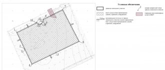
| Appendix 3.6 BOUNDARIES DRAWING | |||||||||||||||||||||||||
| land plot N | |||||||||||||||||||||||||
| The withdrawal was made " | « | 199 | based on | ||||||||||||||||||||||
| administration resolutions | district | ||||||||||||||||||||||||
| Total area of the plot | |||||||||||||||||||||||||
| Geodata: | |||||||||||||||||||||||||
| Name and numbers of items | Rumbas or directional angles | Line length, m | |||||||||||||||||||||||
| Scale 1: | |||||||||||||||||||||||||
| Description of the boundaries of adjacent land uses | |||||||||||||||||||||||||
| from | before | with lands | |||||||||||||||||||||||
| from | before | with lands | |||||||||||||||||||||||
| from | before | with lands | |||||||||||||||||||||||
| APPROVED Chairman of the Committee on Land Resources and Land Management | The withdrawal in kind was made by: | ||||||||||||||||||||||||
| district | « | « | 199 | G. | |||||||||||||||||||||
| region | The plan was: | ||||||||||||||||||||||||
| « | « | 199 | G. | « | « | 199 | G. | ||||||||||||||||||
| M.P. | |||||||||||||||||||||||||
| Appendix 3.7 APPROVED Chairman of the Committee on Land Resources and Land Management | |||||||||||||||||||||||
| M.P. | (district, city, region) | ||||||||||||||||||||||
| (signature, surname, initials) | |||||||||||||||||||||||
| « | « | 199 | G. | ||||||||||||||||||||
| ACT of state control over the establishment and preservation of boundary signs | |||||||||||||||||||||||
| Boundaries have been established | |||||||||||||||||||||||
| (name of organization, enterprise) | |||||||||||||||||||||||
| from the lands | |||||||||||||||||||||||
| (land use) | |||||||||||||||||||||||
| district | areas. | ||||||||||||||||||||||
| As a result of state control, it was established: | |||||||||||||||||||||||
| 1. Technical project (task) for land surveying | |||||||||||||||||||||||
| approved | |||||||||||||||||||||||
| (by whom, when) | |||||||||||||||||||||||
| 2. The act of establishing and agreeing on the boundaries of a land plot | |||||||||||||||||||||||
| designed in accordance with established requirements and | |||||||||||||||||||||||
| approved | « | « | 199 | G. | |||||||||||||||||||
| (by whom) | |||||||||||||||||||||||
| The supporting boundary marks (OMS) have been submitted for safety monitoring. | |||||||||||||||||||||||
| 3. Drawing of the boundaries of the land plot | |||||||||||||||||||||||
| meets accepted requirements and is approved | |||||||||||||||||||||||
| (by whom, when) | |||||||||||||||||||||||
| 4. The survey file is drawn up, bound and prepared for transfer for permanent storage to the archive. | |||||||||||||||||||||||
| The case was accepted by: representative | paradise(mountain)komzem | ||||||||||||||||||||||
| (job title) | (signature) | (surname and initials) | |||||||||||||||||||||
| The case passed: the work manager | |||||||||||||||||||||||
| (job title) | (signature) | (surname and initials) | |||||||||||||||||||||
The purpose of cadastral work is to link the property to the locality, describe this object, and determine the boundaries.
The result of the work declared by the customer in relation to the land plot is a boundary plan.
Only the presence of a boundary plan makes it possible to contact the cadastre services with a statement:
- to register the land plot in the real estate cadastre;
- on amendments to accounting data in connection with changes in the boundaries of the site;
- on registration of part of the site.
There are several stages of work that are included in the concept of “surveying”. This:
- topographic survey;
- fixing the land location diagram on the cadastral map;
- boundary plan and cadastral registration.
Weather conditions are not an obstacle to carrying out cadastral work. Geodetic surveying of a snow-covered surface is much faster, since vegetation or fallen leaves do not interfere.
But coordinating boundaries with neighbors in winter can cause some inconvenience. Firstly, not all landowners live near their plots in winter. Secondly, under the snow it is difficult to determine the location of the boundary and agree on the boundaries with neighbors in order to sign the act.
We invite you to familiarize yourself with: Procedure and deadlines for paying land tax
Land surveying through the MFC: is it possible to speed up the process?
This date is calculated from the moment the documents are received by the Cadastral Chamber specialists. When submitting documents through the MFC, this period increases slightly due to the peculiarities of document flow between different departments. Upon accepting the documents, the MFC employee will give you a receipt and set a date when you can pick up the completed documents. Is it possible to speed up the process? The need to speed up the process of obtaining documents can be caused by various reasons. For example, you are planning to sell your property or provide it as collateral to a bank. You can speed up the procedure, but remember that no one can change the deadlines determined by law.
Is it possible to arrange land surveying through the MFC and how to submit documents
For more than 10 years, Multifunctional Centers have been operating in almost all major cities of the country. In the last couple of years, “My Documents” branches can be found even in remote villages. The list of services provided is constantly expanding. Now you can order land surveying and boundary setting services from the MFC.
Attention! The MFC itself does not provide any services directly related to geodesy and cadastral work. The functions of its employees are limited to receiving documents and transferring them to the organization providing cadastral services.
The MFC does not work with all cadastral organizations, so only those who need the services of an engineer offered by the center can apply here. The client can select it from the list proposed by the center employee.
Here the land user can conveniently contact the “one window” service. The center staff will tell you what certificates are needed and check whether everything is available.
Some documents can be ordered here. After receiving the documents, the customer will receive a receipt indicating the date of the decision.
The registration procedure is simple. User:
- Takes a coupon for the service. If you have difficulty choosing a service, the information desk administrator will tell you how to use the terminal.
- Waiting for his turn. The number from the coupon will appear on the display.
- Hands over the package of documents to the MFC employee, who checks whether everything is available.
- Receives a receipt indicating the date the decision was made.
What is the price and validity period of the land boundary plan?
His task is to survey and determine the coordinates of turning points. All measurements are carried out using geodetic equipment. The survey is carried out using GPS devices, and coordinates are determined via satellite. Then, based on this information, the cadastral engineer will prepare a boundary plan. If necessary, he can request additional information from the cadastre authorities about neighboring areas. An obligatory step is the signing of the border approval act.
This document confirms that your neighbors have no complaints and agree with the established boundaries. The act is signed by the customer, neighbors and a representative of the municipality. There is no need to draw up an act of consent if the neighboring plots were demarcated earlier.
This is interesting: Can SNT sell public land?
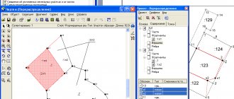
Obtaining a boundary plan
Having the results of geodetic survey and the act of approval of boundaries available, the cadastral engineer prepares a boundary plan.
The boundary plan must be provided in two copies - paper and electronic. The customer keeps the paper copy for himself, and delivers the one recorded on disk to the Cadastral Chamber to register the plot and assign it a cadastral number.
Sample boundary plan:
Deadline for submitting a land survey plan to the MFC from the date of production
- Land surveying: step-by-step instructions
- Land surveying through the MFC: is it possible to speed up the process?
- What is the price and validity period of the land boundary plan?
- What is the deadline for registering a land plot with cadastral registration?
- Is it possible to survey a plot of land for free?
- Deadline for submitting a land survey plan to the MFC from the date of production
Land surveying: step-by-step instructions Important The Multifunctional Center is an intermediary between the Registration Chamber and the owner. Cadastral registration at the MFC If you need to issue not an old certificate, but, for example, a cadastral extract as a result of land surveying, then you come to the MFC with a disk with the survey file that the cadastral engineer recorded for you. When your number lights up on the board, you also go to this window.
It is also necessary to take into account that the location of the boundaries of the land plot is established by determining the coordinates of the characteristic points of such boundaries, that is, the points of change in the description of the boundaries of the land plot and dividing them into parts. Requirements for the accuracy of determining the specified coordinates are established by order of the Ministry of Economic Development of Russia dated March 1, 2016 N 90 "On approval of the requirements for accuracy and methods for determining the coordinates of characteristic points of the boundaries of a land plot, requirements for accuracy and methods for determining the coordinates of characteristic points of the contour of a building, structure or unfinished construction site on land plot, as well as requirements for determining the area of a building, structure and premises.” If the requirements for accuracy and methods for determining coordinates change, it will be necessary to re-perform geodetic measurements (and subsequent adjustments to the boundary plan).
Having in hand the cadastral passport of the plot, a document for the land, a passport of a citizen of the Russian Federation and SNILS, as well as a notarized power of attorney (if the applicant is not the owner), you need to contact the Rosreestr branch (in the old way - justice) to register property rights. An alternative to justice is the increasingly popular multifunctional centers for the provision of public services, where you can also submit documents. To get an appointment, as in the case of the Cadastral Chamber, you must first take a coupon. When submitting an application, you need to fill out a form (basic information about the site and the applicant), which will be provided on the spot, and pay the state fee according to the issued receipt. The state duty at the beginning of 2015 is 350 rubles. After completing these procedures, within ten working days, information about the site is entered into the Unified State Register of Rights.
Receive a copy of the boundary plan for the land plot
Answer: If the rights of a given house are registered in accordance with current legislation, then information about the right holders is contained in the Unified State Register of Real Estate (USRN). In order to obtain the information of interest, it is necessary to make a request in the form of an extract from the Unified State Register of Real Estate, which, in addition to the main characteristics of the property, also contains information about the owner of the requested property for a residential building or land plot. You can request this information at any office of the multifunctional center (MFC), or collection and delivery points of the cadastral chamber. Moreover, the requested document can be received both in paper and electronic form, while the fee for documents in electronic form is significantly less than on paper.
We recommend reading: Do you need a building permit if you own the land?
Question: Hello, I am establishing the boundary of my land plot, but when performing cadastral work it turned out that inaccurate information was included in the documentation of the neighboring land plot. To correct this error, a boundary plan for the neighboring plot is required to enter information into the Unified State Register. How can I get a copy of the boundary plan for a neighboring plot of land?