Home / Real estate / Land / Land surveying
Back
Published: 02/28/2017
Reading time: 14 min
0
1327
In connection with the changes in land legislation that have come into force, land surveying has become a mandatory procedure, without which it will be impossible to sell, divide, merge or carry out other actions to dispose of the land.
If earlier land boundaries were determined only roughly, today it is a complex of geodetic work, during which certified employees go to the site, establish exact coordinates and draw up legal documents for the land.
Our article provides detailed instructions on land surveying.
- What is land surveying?
- Legislation
- Required documents
- How to carry out land surveying stage 1
- Stage 2
- Stage 3
- Stage 4
- Stage 5
- Stage 6
Why is land surveying necessary?
In order to register a real estate property - land, dacha, garden plot, residential building, dacha, garage, apartment - with the state cadastral register, a land surveying procedure is required. Land surveying is work to establish on the ground municipalities and other administrative-territorial entities, the boundaries of land plots, securing such boundaries with boundary signs and determining coordinates.
Only registered land plots are subject to land surveying. Leased land cannot be demarcated.
The procedure is mandatory for the following types of land:
- Transferred for permanent use from state reserves;
- Subject to distribution due to various circumstances;
- Requiring division, consolidation or allocation of a share.
I don’t want to burden you with the technical side of the process. I will not go deeper into the legislative basis of land relations. If interested, read: Land Code, Federal Law No. N 221-FZ “On the State Real Estate Cadastre” (which regulates the procedure for land surveying), as well as the new law “On Amendments to the Land Code of the Russian Federation” dated June 23, 2014 No. 171-FZ - which simplifies the procedure for legitimizing garden plots, carried out in accordance with land surveying free of charge under the dacha amnesty from June 1, 2015, valid until December 31, 2020.
Please note that according to the actual amendments, the provision of paragraph 1 of Art. 19 (Federal Law “On State Registration of Real Estate” dated July 13, 2015 N 218-FZ July 2021) - citizens have the right not to survey their own land plots for sale, purchase or inheritance until the beginning of 2021. After this date, the procedure will become mandatory.
New changes
New amendments were made to Federal Law No. 218 “On State Registration of Real Estate”, which came into force on January 1, 2018. These changes concern the timing of registration of ownership of any real estate, including land.
Such land plots include
the following types :
- plots under C;
- private household plots land;
- areas that belong to SNT;
- for country residence;
- for garage construction.
If a plot of land was registered in the cadastral register more than 5 years ago, but data about it was not entered into the Unified State Register of Real Estate, then it is removed from the cadastral register.
In this case, the municipality will be recognized as the owner of the vacated plot of land.
Another change is that abandoned land, which has been empty for more than 5 years, also becomes municipal property . If the owner is found before the expiration of this period, then he must urgently register his ownership of this land (through the procedure of land surveying and registration).
Otherwise, the issue of transfer of ownership is considered . An application to recognize land as ownerless is submitted by a special department of the municipality in whose territory this site is located.
This category of citizens will primarily include summer residents, many of whom have never registered their property rights. Even if land surveying has been carried out, sooner or later you will have to register the garden plot with Rosreestr so as not to lose it.
Now, according to the law, the land surveying procedure can be cancelled. The essence of the cancellation is not in controversial issues regarding the definition of boundaries, but in the time that has passed since the date of the procedure.
Reasons for the procedure
The establishment of the boundaries of a land plot on the ground is carried out on the basis of an application submitted by the owner or person owning the land under the following conditions:
- permanent (unlimited) use;
- lifelong inheritable ownership.
Applicants may include both individuals and legal entities. Also, ownership can be not only individual, but also joint:
- with allocation of shares in the right to land plot;
- without allocation of shares.
In case of common (joint) ownership, each owner of the share must submit an application. The mediation of a representative acting in the interests of the owners of the land plot is also allowed.
The legality of the application is documented.
The territorial boundaries of a land plot are determined based on:
- formation of a site when allocating a land plot;
- registration of cuttings;
- preparation for a property transaction;
- merger or division of plots;
- disputes with neighbors during land surveying (imposition of land plot boundaries, etc.).
Legislation
The land surveying procedure is regulated by the Land Code of the Russian Federation, the Town Planning Code of the Russian Federation and other special acts of federal and local significance. The above-mentioned “Instructions for land surveying” dated April 8, 1996 are still in effect.
General provisions “Instructions for land surveying” defines some basic provisions of land surveying, on the basis of which this procedure takes place:
- Boundaries on the ground are established and secured when citizens and legal entities receive new land plots (purchase and sale, exchange, donation of an entire plot or part of the land), as well as at the request of individuals or legal entities, if the documentation confirming the rights to their land plot was provided without establishing and securing boundaries on the ground;
- The boundaries of a land plot are restored if there are boundary disputes, as well as in the presence of requests from citizens and organizations in case of complete or partial loss of boundary signs and other signs of the boundaries of their lands on the ground;
- Land surveying is carried out by design and survey organizations of Roskomzem, as well as by citizens and legal entities who have received a license to carry out such work in accordance with the procedure established by law.
Surveying is carried out for the following purposes:
- Registration of land ownership;
- Concluding a purchase and sale agreement;
- Dividing a plot or combining several into one;
- Renting out a house or plot of land;
- Privatization of land.
From 2021, a ban will come into force on the purchase and sale, donation, inheritance and other transactions with land on which the survey procedure has not been carried out.
Land surveying should also be carried out in accordance with the procedure established by the Federal Law of June 18, 2001 No. 78-FZ “On Land Management”, Methodological Recommendations for Conducting Land Surveying of Land Management Objects, Regulations on Territorial Land Management, Regulations on the Procedure for Establishing Land Use Boundaries in Urban Development and others settlements, as well as other legislative acts in the field of territorial land management.
Regulations for land surveying of land management objects
Important! Determining the boundaries of a land plot in accordance with the Land Surveying Instructions is mandatory for state registration of ownership of the plot. This is especially true for those who apply to register land under the dacha amnesty program, valid until the end of 2021.
1996
, is still fundamental to this day who carry out the procedure for determining the boundaries of a land territory.
In addition to the basic provisions, the Instructions for Land Surveying define the procedure for preparatory procedures for monitoring geodetic support, drawing up a technical plan, a drawing of boundaries and the procedure for their approval, and appealing the results of border registration.
The instructions for land surveying are also supplemented by several appendices - samples of technical specifications, drawings and documents that form a package of documents.
2003
In 2003, the Federal Land Cadastre Service of the Russian Federation approved additions to the instructions in the form of “Methodological recommendations for carrying out surveying of land management objects.”
In their edition dated April 18, 2003, some clarifications were proposed to the requirements for how the technical project is prepared, accuracy in the procedure for determining the boundaries themselves, amendments to the design of the site map, etc.
What is the difference between these two guidelines?
The methodological recommendations for conducting land surveying of land management objects given above differ from each other. The main difference between the two regulations that guide cadastral engineers in the procedure for determining the boundaries of land plots is the guidance of the main and auxiliary documents.
The Roskomnadzem instruction, as amended in 1996, is to this day the main regulatory document that serves as the basis for formalizing all delimitation actions.
Methodological recommendations from Roszemkadastr, approved in 2003, are expanded additions to the existing regulatory procedure set out in the 1996 Instructions, but, basically, do not contradict it.
Attention! Despite the fact that the Land Surveying Instructions are a guideline in the procedure for determining the boundaries of plots, its provisions are not used in the part that contradicts Federal Law No. 78-FZ “On Land Management” dated June 18, 2001, as well as the Methodological Recommendations themselves for organizing procedures, that is the latter in relation to the Instructions are an update of some of its points.
To survey a land plot, documents are required. In our articles you can familiarize yourself in detail with information about the land survey act and the power of attorney.
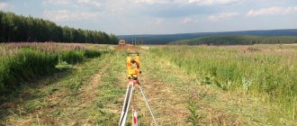
How is the land survey day going?
As a rule, on the day of surveying, a call is received from a specialist from a geodetic company notifying him of a visit to the site. They inform both the customer and neighbors. We will return to the issue of informing neighbors before land surveying.
So, upon arrival at the site, the cadastral engineer or his assistant:
- Will make a general measurement of the land plot;
- Determines the coordinates of boundary markers;
- Determine the boundaries, coordinate them with adjacent land users and document the agreement (act of land survey approval). If there are no complaints, the on-site surveying procedure is completed.
As a rule, land surveying takes place autonomously (without your participation). If you want to participate, plan to spend 1-2 hours on the day of surveying.
How to choose an engineer for land surveying in 2021
The qualifications and experience of the engineer involved directly affect the compliance of the finished package of documents with the legislation in this area. Accordingly, to the question: “how to survey a plot of land?” The answer is to find a professional.
Federal Law No. 221 specifies a list of requirements for specialists:
- presence of Russian citizenship;
- availability of higher education and a certificate that confirms qualifications;
- not convicted;
- the candidate must have at least 2 years of experience as an assistant specialist in this position;
- the employee must be a member of a self-regulatory body of specialists in this profession;
- have a valid compulsory insurance contract;
- availability of a compulsory civil liability insurance contract;
- not disqualified for this specialization.
In addition, it is worth paying attention to these aspects of hiring a surveying contractor:
- It is advisable to familiarize yourself with the activities of the SRO in which the hired specialist is a member.
- pay attention to the reviews of those who have previously applied to this organization;
- study the result of previous work, due to the need for experience in the active application of knowledge and theoretical training of the employee.
Despite the importance of the cost of cadastral engineer services, there is no need to give priority to this indicator. It is more important to ensure the professional skills of the engineer who is entrusted with the work of determining the boundaries of the sites. The absence of complaints is a marker of a good CI.
Required documents
For individuals, the following documents will be required:
- A document proving the identity of the applicant or a power of attorney to represent the interests of the customer and his passport.
- Title documentation for the land plot: Municipal resolution on the allocation of a land plot, terms of reference (certified by the general department of the local government);
- Land purchase and sale agreement;
- Land donation agreement;
- Certificate of legal right to inheritance;
- Certificate of state registration of rights;
- Documents from BTI.
Legal entities must prepare:
- Title documentation for the land plot: Municipal resolution on the allocation of a land plot, terms of reference (certified by the general department of the local government);
- Land purchase and sale agreement;
- Land donation agreement;
- Certificate of legal right to inheritance;
- Certificate of state registration of rights;
- Documents from BTI.
- Documentation confirming the competence of a representative of a legal entity (power of attorney, charter);
If any of the above documents are missing, this does not mean that land surveying will be impossible. Everything is discussed individually.
Programs
Land surveying programs were introduced for the reason that many lands of economic importance were empty (not cultivated, not used for enterprises).
The content of these programs is aimed at increasing the efficiency of land resource use and investment.
Departmental
Many land plots located on the territory of municipalities do not have documents confirming that these real estate properties belong to the municipality.
But at the same time, such land could be serviced from local budgets.
To ensure that such facilities are not left unattended, additional funds are allocated for their maintenance on the basis of a departmental program.
This program provides for the transfer of undocumented objects to municipal ownership and registration of ownership . As well as the allocation of additional funds for routine repairs and maintenance.
These works must be carried out as soon as possible and at the expense of the state budget .
The losses caused by the absence of the owner for many years exceed the costs of registering and maintaining land plots.
Municipal
Municipal programs are aimed at implementing the procedure for registering land under apartment buildings in a short time.
At the moment, all the plots that are occupied by such houses according to documents belong to municipalities. The owners of the apartments are their full owners only in words.
In fact, they are only the owners of the area within which their apartment is located.
The municipal land surveying program provides for apartment residents to receive shared ownership of the land that belongs to their home. Funds are allocated for this, as well as for the formation of the tax base for land tax on this land.
Why is the land surveying procedure carried out?
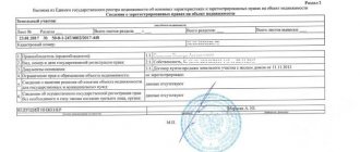
After the procedure, the owner of the land plot receives a boundary card, which contains all the necessary data about his allotment. In particular, the area, coordinates of the end points, as well as a diagram of the territory are indicated. In addition, land surveying is resorted to in the following situations:
- If you need to highlight the boundaries of the allotment, as well as their designations.
- When it is necessary to generate unified information in the cadastral registration database.
- To carry out any transactions related to land (sale, re-registration of rights, privatization, and so on).
In addition, the results obtained can be useful in various types of legal proceedings, for example, when challenging the cadastral value of a plot and so on.
Land surveying: what is it and why is it necessary?
Land surveying is one of the types of cadastral work aimed at defining, clarifying and restoring the boundaries of a site, as well as establishing its coordinates. This procedure is mandatory and regulated by the following regulations:
- codes - Land and Town Planning (Land Code of the Russian Federation and Civil Code of the Russian Federation);
- Federal Law No. 218 “On Registration”;
- “Methodological recommendations for conducting land surveying” (approved by Roszemkadastrom on February 17, 2003);
- Instructions for land surveying (approved by Roskomzem on April 8, 1996);
- action plan “Improving the quality of government. services in the field of state cadastral registration of real estate and registration of rights" (Road Map).
Without carrying out such cadastral work, it is impossible to determine the location of the land, separate it from the adjacent territory, combine several plots into one or, conversely, separate them. Therefore, without defining the exact boundaries, it will not be possible to carry out legally significant actions with the land:
- registration of land plots for cadastral registration;
- buying and selling;
- donation;
- privatization;
- registration of inheritance (find out all the nuances of inheriting land plots);
- construction and registration;
- other.
If land surveying was previously carried out and data correction is not required, then the customer has the right to refuse to repeat the procedure.
Land surveying is also carried out if land disputes arise between neighbors. In this case, a forensic expert will survey the disputed areas, and a decision will be made based on the data obtained.
Have your neighbors installed a fence on your property? Write to our specialists in the chat on the right, and we will definitely help solve your problem. Also read: list of actions if a neighbor has seized part of the land plot.
In addition to the indicated cases, land surveying is necessary when connecting gas, electricity or water supply to the house, since the geodetic survey carried out during land surveying will be needed to draw up a situational plan.
Find out what a situational site plan is.
Based on the above, land surveying has significant advantages:
- unhindered disposal of the site;
- absence of controversial issues with neighbors;
- paperwork for carrying out any procedures is much faster (for example, obtaining a building permit).
Land surveying also allows you to select a specific area from the entire territory.
However, there is also a negative point in the demarcation - the price. In most cases, this service is provided for a fee, but we will talk about this below.
How much does land surveying cost?
The activities of cadastral engineers are non-departmental, therefore prices for land surveying are not regulated by the state. There is a method for calculating the cost of cadastral work, but only municipal organizations adhere to it, and the speed of completion of work is not the highest.
Private firms set their own prices, focusing on the supply and demand market. The cost of land surveying is influenced by: region, category of land, area, location and shape of the site (simple, complicated, geometrically complex, etc.).
Often, in order to develop a client base, “young” companies try to keep prices below market prices, but the quality of services is in no way inferior to experienced companies. In any case, do not stop at the first surveying organization whose advertisement caught your eye.
The cost of land surveying in the Moscow region varies from 10,000 to 30,000 rubles. In the Leningrad region 7-15 thousand. In the regions, land surveying costs about 5 thousand rubles.
You may be able to agree on payment for the work in advance, for example: 50% upon conclusion of the contract and another 50% upon completion of the work. Don't forget to keep your receipt and payment receipt.
Deadlines for land surveying
The timing of land surveying is usually limited to a time period of 1 to 5 months, depending on the level of complexity of the work. Sometimes it is increased, so it is impossible to say exactly the period of land work. Much will depend on the area, complexity of the terrain and territorial extent.
The surveying procedure can be carried out at any time of the year. Weather and seasonal conditions have absolutely no impact on the duration of work. The vast majority of surveying companies use modern equipment that can work even in adverse weather conditions.
What difficulties may arise during land surveying?
Each survey of a land plot requires a special approach from its owner.
The main thing here is not so much the presence of a large number of legislative acts in the field of establishing boundaries, but rather objective factors, that is, the specific features of the land to be surveyed.
Here are a few of the features that can create problems for the owner when carrying out land surveying:
- The land plot is located in a protected area;
- The land plot is located within the boundaries of public use;
- The presence of legal claims in relation to the land;
- Hereditary moments;
- Self-capture of a site and so on.
The above features are more decisive when carrying out land surveying than specific legal requirements.
It is important to take into account that the main provisions of land surveying are common for the entire territory of Russia, however, each region, district or big city (Moscow, St. Petersburg) establishes its own special rules for conducting the land surveying procedure.
How to notify neighbors about land surveying
An important point is to notify the neighbors with whom the land plot borders about the date and time of the specialist’s arrival before the survey begins. By taking your civil passport with you, your neighbors will have to confirm their agreement with the new boundaries of your land plot. If the land plot is located on the territory of a dacha or garden partnership, then the consent of the Chairman of the Board will be required.
As a rule, informing neighbors falls on the shoulders of the contractor and must be specified in the contract. You can notify your neighbors by phone, but it will be more reliable in writing - by sending a registered letter with acknowledgment of delivery via Russian Post.
However, the neighbor has the right to refuse to sign the deed...
Is it possible to do land surveying yourself?
Land surveying determines the exact boundaries of a land plot. Surveyors take measurements of the area of the site. It is impossible to do land surveying yourself, not only because of the need for special knowledge and skills, but also because of the requirements for qualification certification.
Land surveying is a procedure not only of a technical nature, but also of a legal nature. The company that carries out land surveying has the official right to assign an individual state identification mark to a land plot. The assigned state sign is subsequently entered into the register of land plots.
Therefore, carrying out land surveying on your own is simply unacceptable by law.
Is it possible to do land surveying for free?
In accordance with the general rules, boundary work of land plots is carried out according to the technical specifications of the owner on the basis of a drawn up contract. The form of contractual relations implies a paid nature of the service at the expense of the ordering party. The parties set the price for the services provided independently.
However, citizens have the opportunity to carry out land surveying at municipal expense, that is, free of charge. Such an event can be carried out during complex work on cadastral registration, where the municipal entity acts as the customer.
For more information about the cost of land surveying, read our article.
The following features are worth noting in this procedure:
- the owner of the site does not have the opportunity to influence the deadline for completing the work, since it depends on the decision of the municipal authority;
- complex work is fraught with errors made in the process of clarifying the boundaries of a particular site;
- a land owner who does not agree with the result of land surveying may file an appeal to a special commission on this issue.
To clarify the timing of the free procedure, a citizen must monitor publications in the official source of the municipality.
What to do if your neighbor doesn't agree
N-e-e
When surveying a plot of land, disputes with neighbors are common, but you will still have to seek a compromise. In my opinion, it is better to give in a little to an intractable neighbor in order to end the process (give less to get more), since going to court to resolve a dispute is not a quick process, nor is it free (from 15 thousand). In general, my advice to you is to document any refusal, it will come in handy. If it comes to court, be prepared to raise the story of who, to whom and within what boundaries the plot was transferred earlier.
Result of surveying and registration in Rosreestr
The owner of the site - the customer of the service - receives a ready-made survey plan or survey report, which must be signed by the surveyor, the customer himself and the neighbors who were present during the measurements. Documents are submitted to Rosreestr for state registration and entering data into the Unified State Register of Real Estate. And the cadastral engineer draws up the survey file and submits it to the Committee on Land Resources and Land Management. It will be archived permanently.
Any citizen will be able to find out that land surveying was carried out and who the cadastral engineer was. To do this, you can use the public map of Rosreestr for free and enter the cadastral number of the plot in the search. Information about the requested territory will appear in the window that opens.
To register ownership of a demarcated land plot, you need to pay a state fee, the amount of which is 350 rubles. for garden, summer cottage plots and lands for individual housing construction, private household plots. Registration is carried out by personally contacting Rosreestr or on the official website, at the MFC or through the State Services portal, as well as through a representative by proxy.