In the process of determining the boundaries of a land plot that has a boundary plan drawn up earlier, situations sometimes arise in which the boundaries determined by the cadastral engineer differ from those indicated in the register .
In this case, there is a need to make changes to the boundary plan and, in parallel, the issue of the legality and possibility of changes to the boundaries of the land plot will be considered.
What it is?
Clarifying the contour of the plot consists of documenting deviations of the received data from those contained in the previously drawn up boundary plan.
In fact, changing boundaries may involve the following actions :
- Changing the configuration of the contour line defining an area of land while maintaining the value of the original area. In such a situation, when entering data, part of the area in a certain place of the formed figure decreases, in another it increases, and in general the value remains identical to that indicated in the cadastral passport. In parallel with this lack of a procedure for affecting the value of the area may mean that in fact the area remains the same, and only the data in the boundary plan will change, which for a number of reasons contains erroneous information;
- Changing the boundary while simultaneously clarifying the values of its area. In such a situation, existing cadastral registration errors can be corrected or boundary changes can be made directly on the ground while simultaneously adding ownerless territory as an “addition” to the extent permitted by the Land Code.
Changing the boundaries of a land plot
- In case of cadastral error. Then the geodetic company that made a similar error in the documentation carries out the land surveying work again and draws up a new cadastral plan with changed land boundaries.
- At the initiative of the owner. When one plot is divided into several, as well as when two or more plots are combined into one. And in this case, it will be necessary to carry out boundary work again.
- When clarifying the boundaries of the land plot. The owner resorts to the procedure for changing the boundaries of a plot of land if, when clarifying the boundaries, it turns out that the actual area of the plot differs significantly from that indicated in the documents. To avoid having to register a change in the boundaries of the site, the deviation in area cannot be more than 10%. If this indicator is exceeded, the owner has no choice but to change the boundaries of the land plot.
We recommend reading: Calculate the amount of VAT 18% for several items
In such a situation, it is necessary to officially approve the newly emerged boundaries with changed parameters. Here it is impossible to do without carrying out a special type of work on the site. It is about changing the boundaries of a plot of land and what needs to be done for this that will be discussed in this article.
In what cases might it be necessary?
The need to replace the boundaries of a land plot may be associated with various reasons, and the procedure for entering new data and grounds for such an action will be slightly different.
Cadastral error
If cadastral errors occur, the data contained in the register will have different boundary values from what the land actually has .
Cadastral errors can occur due to the engineer entering incorrect data, using faulty equipment, or making errors in calculations.
You can find out more about the causes of cadastral errors and how to eliminate them in our article on this issue.
Owner's initiative
Redistribution of the boundaries of a land plot may be permitted at the initiative of the owner of the plot.
In this case, the owner has the opportunity to apply both
to clarify the line limiting the site, when valid data is restored in the process, and to enter them into the plan and cadastral passport .
This becomes possible if, during the preparation of any documentation or direct use of the land, discrepancies were noticed in the data and the actual area or configuration of the boundary.
Clarification of boundaries
The boundary can be clarified on the following grounds:
- The need to update data in connection with the planned registration of transactions for the allotment or construction of real estate;
- In the absence of valid data on this plot in the state real estate cadastre;
- If errors are detected in the cadastre, which are associated with exceeding the permissible norms of deviations (errors) at boundary turning points and directly passing contours defining the area owned by an individual or legal entity;
- When the owner expresses an independent desire to determine the boundary.
Clarification of the boundaries of a land plot: procedure
The main reason for reducing the area of a site is the fact of encroachment on territory belonging to other persons or organizations. Errors in the plan (cadastral and boundary) are also reasons for clarifying the boundaries of a land plot with a decrease in area. The procedure is identical to increasing the boundaries, only the result is different - reducing the area.
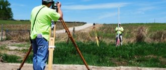
All actions must go in a certain order. The order is the sequence of clarification of boundaries, which is established by law. The law determines that the owner must give the cadastral engineer the opportunity to familiarize himself with all the necessary documentation for the land plot. This is done so that the engineer can understand whether it is necessary to carry out additional work (except for computational work).
Features of the change procedure
A change in the boundaries of an allotment may have characteristic features depending on whether, in connection with the clarification of the location of the line defining the boundary of the land plot, its area will also change.
Area-preserving transfer
Changing the contours of a land plot while maintaining its area consists of clarifying all turning points and drawing a boundary between them .
In most cases, such a procedure consists only of entering valid data on a land plot in situations where the national register contains information that does not correspond to reality.
In this case, the area of the plot remains unchanged, however, entering data on it requires compliance with the procedure, which consists of taking measurements, collecting cadastre data and agreeing on the boundaries of the plot with neighbors .
No saving
When changing or transferring boundaries with a simultaneous change in the area of the allotment, an important factor is to provide documentary evidence that such a process can take place.
The change in the area of the site itself may be due to the following reasons:
- Making mistakes when carrying out land surveying , when turning points were installed on the site erroneously and the passing boundary does not correspond to reality. In such a situation, problems may arise if the boundary that is subject to change was agreed upon with the owners of neighboring lands. On the other hand, by collecting the necessary documentation and providing conclusive evidence of the error, changing the area is possible;
- Changing the boundary by adding additional area to the main part of the land plot. Such an area has certain restrictions and cannot be larger than the size established by law, depending on the category of land use.
It is possible to add an area to a land plot only if such a plot is ownerless and there are no claims regarding its ownership or encumbrance.
How to change the cadastral boundaries of a land plot
To carry out the procedure, it is necessary to proceed from the motivating situation that caused this need. The fact that requires repeated land surveying must be officially justified , that is, the owner of the land plot presents, along with a package of documentation, one of the documents:
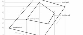
This is the drawing of boundary lines according to the coordinates of the specified area. Turning points are determined more accurately. When the configuration of the plot changes, its area remains unchanged. That is, there is a shift in part of the border of the land plot, which leads to the need for redistribution of land plots.
Who can apply?
An application for changing the boundary can be made from certain persons who have grounds for such actions.
Such persons include citizens, as well as individuals or legal entities who have ownership rights to the plot in relation to which the question of clarifying the passing boundary arises.
Also, those who are users of the allotment with the subsequent transfer of ownership of it may also have the right to change indicators.
However, in such a situation, most areas do not even have a boundary plan yet, so we will not be talking about changing the boundaries, but about establishing them.
Where to contact?
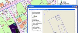
Changes in the boundaries of the site must be accompanied by the provision of data to Rosreestr .
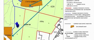
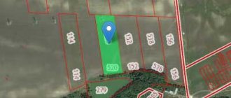
Such data is sent in the form of a compiled boundary plan containing the actual coordinates of the turning points through which the boundaries will pass with an acceptable degree of error, repeating those boundaries that exist in nature.
The preparation of such a boundary plan can be carried out by a cadastral engineer who has permission for this type of activity and is included in the register on the Rosreestr website.
How to change boundaries after surveying?
Changing the boundaries of a site after the land surveying procedure has already been carried out, and during the period allotted by law for requests from persons directly interested in clarifying the data, an application has not been submitted, the data on the site provided based on the survey results are entered into the state register data.
In such a situation, if it is necessary to change the boundary, first of all the owner of the plot contacts Rosreestr to be able to enter valid information.
The standard procedure is to refuse such an action, since the procedure for the formation of the boundary plan has been followed.
Next, the owner of the plot, in order to protect his rights, applies to a judicial authority , where, as a result of consideration of the application and attached documents, the legality of such an action is determined and a cadastral engineer from the organization where the owner applies draws up a new boundary plan.
If the court’s decision is positive, then the decision must be submitted again to Rosreestr, whose specialists, based on new data on the boundaries of the site, must enter information.
How to change the cadastral boundaries of a land plot
As a general rule, in order to make changes to the boundaries of a plot, it is necessary to obtain the consent of neighboring plot owners. More precisely, it is necessary that the owners of neighboring plots not express objections to this matter. When surveying, it is usually necessary to coordinate the established boundaries with the owners of adjacent plots.
In other words, this is a partial change in the location of the plot, when one of the owners expands the boundaries of his plot, while the neighboring plot moves exactly the same distance in order to keep its area unchanged. Based on the results of the shift, each of the newly formed areas will be assigned new cadastral numbers.
We recommend reading: Documents Required to Obtain a Tax Deduction When Purchasing an Apartment
If the land is owned, but there is no land survey
Often there may be a situation in which a certain person has title to land, but there is no boundary plan for it.
This may be due to the peculiarities of the transfer of ownership of the land, as well as the period of time in which this occurred - perhaps due to the lack of certain regulatory standards, the registration of the site occurred without action to determine the actual boundary .
In this case, the owner must understand that when trying to sell a plot, register a deed of gift for it, build a real estate property, etc., he will be faced with the need to provide data on the passing boundaries of the plot.
In such a situation, you should not hesitate , since establishing boundaries is a fairly lengthy procedure and if there are disputes regarding them, drawing up a boundary plan can take up to 6 months.