Many people affected by agricultural legislation do not know whether land surveying is really necessary.
Most sites claim this is true. Moreover, this must be done as quickly as possible. At the same time, they even refer to non-existent laws.
Using land surveying, the boundaries of the site are determined.
Only qualified personnel take part in it : surveyors and cadastral engineers who have a special certificate. The received data is entered into the Unified State Register of Real Estate.
What it is?
Land surveying is a procedure that includes several stages. After everything has been completed, you can get results with an accurate (to the centimeter) indication of the boundaries of the site.
Land surveying includes the following stages :
- study of land documents;
- judicial materials, results of land management examination (in some cases);
- processing old data (if any);
- geodetic work on the ground;
- coordination of boundaries with neighbors (not always);
- processing of received information and preparation of documents for Rosreestr;
- drawing up a land survey.
Borders are fixed with special boundary signs: pegs, posts, metal marks.
Surveying cannot be done independently . Here we need a specialist with a qualification certificate, a cadastral engineer.
What if the survey is not completed?
Only the residents of the apartment building will be left in the red. Here is a short list of the consequences of inaction in land surveying matters:
- Residents will not be able to demand from management companies basic cleaning of the territory, maintenance of yard landscaping and other privileges. In addition, there will simply be no responsible person;
- as a result of legislative amendments in 2010, an unregistered local area is the reason for the refusal of the entire house to participate in the capital repair program. It turns out that the residents will not receive either repairs, money, or the site itself;
- and the Town Planning Code of the Russian Federation itself states that such a house with confusion over the ownership of the territory cannot be overhauled, reconstructed or other large-scale work.
You should not lose sight of the obstinacy of the residents of neighboring houses - if the land surveying is not properly formalized, “friendly” neighbors will happily and legally be able to take away the adjacent territories from the residents. But if you try to defend your case in court without having documentary support, you will have to wait ten years, and then without any guarantee of victory!
Why is this procedure needed?
The main purpose of boundary work is to determine the exact boundaries of the land plot.
There are several reasons why a land owner uses the services of a cadastral engineer:
- Find out the boundaries of your site and its exact area . It is the natural desire of every person to know exactly what is his property. Sometimes this need coincides with the intention to put a fence around the perimeter of the site. Then the expensive land surveying procedure does not seem so, since demolishing or rearranging the fence and outbuildings may be more expensive.
- Sale . It is known that the buyer prefers to purchase not a pig in a poke, but real property with exact outlines. This can be confirmed by a boundary plan with border coordinates.
- Share allocation. If the plot is registered to several owners, but is not demarcated, then the sale of one part must be preceded by a land surveying procedure, with the help of which it is possible to determine exactly where the boundaries of the share lie.
- Disputes with neighbors about boundaries . A common reason for contacting a cadastral engineer.
- Building a house . Before starting, you need to obtain a building permit. To do this, among other documents, it is necessary to provide a boundary plan containing a graphic part (site drawing). Therefore, the land surveying procedure in this case will be mandatory.
You can find out whether land surveying took place from documents: cadastral passport, Certificate, extract from the Unified State Register or on the official website of Rosreestr.
When is land surveying necessary?
So is it necessary to survey the land? The need to survey a land plot arises, as already mentioned, in the following cases:
- discussions with neighbors regarding the boundaries of the site;
- privatization;
- your land is adjacent to an ownerless one and you decide to expand your plot to include “uninhabited” territory;
- you are going to build a permanent structure.
If you are the owner and have a cadastral passport, land surveying is not necessary.
There is nothing complicated in the procedure itself - a contract is concluded with a licensed geodetic company, which creates a land survey and draws the boundaries of your territory. However, there is one difficulty here - you are obliged to notify your neighbors about the procedure. Whoever they are - land owners or just users, their opinion must be taken into account.
To do this, you need to send them a written notification by registered mail with notification. If they don’t come, then, in principle, you can do without their participation - but where is the guarantee that your neighbor will not later declare that you are violating his rights?
One can be considered completely insured against such a case only if the neighbors have not appeared at home for a long time and no one knows where to look for them, as well as whether they are even alive. So we still have to negotiate. And here the following difficulties may lie in wait:
- the neighbor refuses to sign the preliminary plan and does not justify this in any way - then you will just have to wait until he refuses twice, or still gives reasons;
- the neighbor refuses to sign and justifies his position.
In the second case, the issue can only be resolved in court. It is written here about whether it is necessary to obtain the signatures of neighbors and what to do if they refuse this.
Is it necessary to comply with the law?
The dacha amnesty has been extended once again. This time until 2021 . This means that it is possible to register ownership of land plots using a simplified system. Let's take a closer look at this process.
In order to register a land plot under the dacha amnesty, you will need a minimum package of documents :
- passport;
- land allocation act;
- technical plan of the land plot.
All documents along with the application are submitted to Rosreestr. The information is processed and the site is entered into the USRN database.
The ownership of a plot is not only registered. It is assigned a cadastral number. This means that from now on it is on the cadastral register. That is, in fact, all the documentation for the sale of this plot is available.
Not all owners have the right to a dacha amnesty .
This applies to land plots that were provided before 2001 for individual housing construction, dacha and garden farming, and private household plots.
Land marking cannot be avoided. The dacha amnesty has been extended until 2021.
- What to do if the land lease agreement has expired
- Changing the purpose of garden plots
- Expedited receipt of an extract for a house plot apartment in Istra
- Land surveying in Krasnogorsk
- How to register a house without a building permit in 2021
- Legalization of the construction of a residential garden house
- How to register an addition to a land plot in 2021
- Registration of a residential building on a land plot in 2021
- BTI technical passports lose their validity
- Urgent extracts from BTI technical passports
- How to obtain a BTI Technical Passport
- Is it necessary to change the technical passport for a house or apartment?
- Why do you need to survey land plots by clarifying their boundaries in Rosreestr?
- Is it necessary to survey the boundaries of summer cottages in 2021?
- The need to survey land plots in 2021
- Description of the stages and methods of land surveying
- Construction and registration of houses and outbuildings on individual housing construction sites
- Use of real estate located in a zone with special conditions for the use of the territory
- New rules for transferring an apartment to non-residential premises
- How to obtain permission to build a gas station in Moscow and the Moscow region
Peculiarities
Land surveying consists of several stages. First you need to find out whether this procedure was really not carried out on your site . Then collect all the documents for the site and conclude an agreement with the organization of cadastral engineers.
Is it necessary to do this if the plot is registered in the cadastral register?
According to Russian legislation, land surveying is carried out only at the request of the owner of the site. If the land plot was registered in the cadastral register according to a simplified system, without carrying out a land surveying procedure, then it is not necessary to do it before selling it (for more details, see here).
Currently, in order to sell a plot,
you need to provide the following to Rosreestr :
- Owner's passport.
- Certificate of ownership or extract from the Unified State Register of Real Estate.
- Technical documentation (landmark plan, technical plan).
- Contract of sale.
Technical documentation, including a cadastral passport, is needed only for entering data into the Unified State Register of Real Estate.
To transfer ownership from the seller to the buyer, these documents are not needed. Brief cadastral information is available in the extract from the Unified State Register of Real Estate.
From 2021, instead of a Certificate of Ownership made on special paper, an extract from the Unified State Register of . It is printed on plain paper and contains cadastral information about the property.
It also indicates the ownership of the property of the specified person. The certificate and extract are legally equivalent.
If the land is owned
What if the land is owned, but no land survey has been carried out on it? The answer to this question must be given by the owner himself. After all, the determination of boundaries is a voluntary procedure and is carried out in the interests of the owners (read more here).
If the previously registered plot does not need to be sold, donated, or bequeathed in the near future, then you can wait with land surveying. Before selling, there is also no obligation to call a cadastral engineer if you are sure that you can sell it for the real price anyway.
Summer residents will save on cadastral work
During land surveying, the boundaries and area of the land plot are determined. It is this data that is of practical importance when making transactions with land and drawing up purchase and sale agreements, leases, etc. Having the information obtained during land surveying, the owner will always be able to distinguish his plot from neighboring ones, as well as use various ways to protect his rights.
Why is land surveying necessary for site owners? The most relevant areas for using the results of such work can be identified:
- when it is necessary to register rights to a new plot when allocated by authorities;
- when one plot is divided into several new ones, or, on the contrary, plots are united into a single land mass;
- when it is necessary to clarify the boundaries to resolve a dispute between the owners of neighboring plots.
The boundaries established during land surveying can always be visually displayed on the ground. For this purpose, boundary signs, fences and other types of fencing are used.
Expert advice . Land surveying allows you to resolve a dispute between the owners of adjacent plots regarding the boundaries of the area. To do this, a boundary approval act is drawn up, and if there is a conflict, boundary documents will be used as evidence in court.
To carry out land surveying, the customer must contact a cadastral engineer to conclude a contract. To do this, the owner of the site must submit:
- documents confirming the existence of a legal right to the site (agreement, resolution of authorities, certificate of inheritance, etc.);
- identification documents of the customer.
The engineer will receive all the other necessary information as a result of survey work on the ground, as well as from previously collected cadastral information about adjacent areas.
Expert advice . In some cases, land surveying is not required to register land rights. For example, the “dacha amnesty” program, approved by Federal Law No. 93-FZ, allows for a simplified procedure for registering a number of objects (plots for garages, dachas, etc.) without land surveying. However, to dispose of such objects after January 2021, it will still be necessary to carry out boundary work.
In accordance with Art. 22 of Federal Law No. 78-FZ “On Land Management”, boundary (land management) business includes land management documentation for each property. The composition of land management information is determined by the Roskomzem Instruction dated April 8, 1996.
The survey file is subject to approval after its formation, and then sent to the state archive for storage. In case of changes in information about the site, which required additional survey work, changes are also made to the survey file.
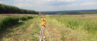
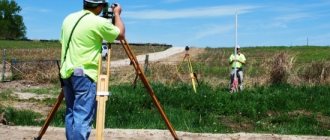
Land surveying work in Moscow and St. Petersburg, as in other regions of the country, can only be carried out by cadastral engineers who have a professional certificate. Each cadastral engineer must be a member of a specialized self-regulatory organization (SRO).
Based on the results of the work performed, the cadastral engineer sends the boundary plan to the following authorities:
- for Moscow – Federal State Budgetary Institution “FKP Rosreestr” for Moscow;
- for St. Petersburg - FSBI "FKP Rosreestr" for St. Petersburg;
- The Leningrad region and the Moscow region are similar cadastral institutions under the Rosreestr Administration.
In order to quickly and efficiently carry out land surveying, you need to choose a cadastral engineer wisely.
Only a specialist can carry out the process of establishing the boundaries of the site, its area and exact location. This is what a cadastral engineer is. This can be any person (individual, legal entity or individual entrepreneur), but must have an official document.
A certificate issued and registered in Rosreestr is confirmation that he has sufficient qualifications to provide such a service.
To obtain such a certificate, candidates are required to meet a number of requirements:
- it is necessary to have a professional education;
- pass exams to confirm qualifications;
- An engineer will be allowed to work independently only after a two-year internship as an assistant cadastral engineer with experience.
Next, all that remains is to register the plot of land, for which you will need to prepare several more documents that will need to be presented to the registration authority.
In addition to the boundary plan, you need to take with you your passport and documents confirming the right to the site. An application in the prescribed form can be filled out directly at the Rosreestr authority. If the interests of the owner are represented by a trustee, then it is necessary to submit a corresponding power of attorney.
All that remains is to pay the state fee (cost 350 rubles) and wait for changes to be made to the database. The registration period is established by law and cannot be more than 10 days. The result of completing the registration record will be an extract from the Unified State Register.
A quarrel over the division of land turned two neighbors into enemies
There is no legal deadline for completing land surveying work. It is formed from several criteria:
- terrain features,
- terrain complexity,
- number of areas for land surveying,
- allotment area.
If the boundaries of a plot for individual use, as well as a dacha plot, are marked, and there are no disputes regarding the marking with neighbors, then the process takes approximately 15-20 days . The exact date of completion of the work by the cadastral engineer can be specified in the contract.
The cost of surveying services is set directly by the organization that has the right to perform such work. Therefore, before concluding a contract, read the price list.
The price is formed from the list of works that need to be performed by the engineer. We list approximate prices. They can differ significantly not only in different regions, but also within the territorial unit itself.
Price
Land surveying is a rather complex process that includes a whole range of activities. The final price for the services of a cadastral engineer will depend on their quantity.
Also among the circumstances that affect the cost of surveying are:
- Land area . The larger it is, the correspondingly more work the specialist has to do and the higher the price.
- Region . Each region has its own price for cadastral work. For example, the cost of the same services in the Moscow region and the Smolensk region may differ by double or more.
- Configuration _ If the site has a simple rectangular shape, then its boundaries are much easier to determine.
- Landscape . Ravines and hills greatly complicate the work of a cadastral engineer.
- Availability of objects on the ground . This includes the house, outbuildings, trees and other plantings.
- Distance from the cadastral engineer's office . Sometimes the land plot is located very far from a large populated area where cadastral engineers work.
In general, the average cost ranges from 5 to 15 thousand for a standard dacha plot of 6 acres.
It is necessary to discuss in advance all the nuances of the estimate for boundary work. Preferably before signing an agreement with the company, which includes the cost of land surveying.
Why is land surveying needed in 2021 - 2021 and how to find out if it was carried out
Important! Coordination through submission of advertisements to the newspaper can only be carried out in the case when you cannot find neighbors, and there are documents confirming this fact
- Fourth stage. Your cadastral file is generated in electronic form, containing scans of all documents, a boundary plan and certified by the electronic signature of a cadastral engineer. The data is recorded on a CD for transfer to Rosreestr.
- Fifth stage. Submission of data to the MFC (hand over the disk) is carried out by the owner or his authorized representative using identification documents. A fee of 350 rubles is paid for individuals.
Rosreestr has entered into agreements with 13 regions, which received subsidies from the federal budget for the implementation of complex cadastral work within the framework of the Federal Target Program (FTP) “Development of a unified state system for registration of rights and cadastral registration of real estate (2014 - 2021).”
What will the owner of the site receive as a result?
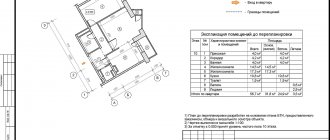
After the specialists have completed all the necessary work, the owner is provided with a boundary plan. This document consists of text and graphic parts. The text part contains the following information:
- initial data;
- boundary changes;
- area and coordinates of the site;
- conclusion of a cadastral engineer.
The graphic part includes:
- allotment diagram;
- geodetic constructions;
- diagrams of constructed objects;
- border drawings.
Help: if after the completion of the measurement the boundaries or area of the site have changed, then the owner must submit the boundary plan to the land resources committee.
Why is land surveying necessary?
The most common reasons for such work are highlighted:
- To register rights to a plot that was allocated by authorities.
- When dividing a large plot into several small ones or, conversely, combining small ones into one large one.
- If disputes arise between the owners of neighboring plots.
Fences, barriers and various types of markings are boundary signs that establish boundaries.
Land surveying is also necessary to establish any type of real estate for state cadastral registration. The procedure can only be carried out on those plots that are owned. Land surveying is prohibited on leased areas.
For some types of land the process is required:
- For plots transferred for permanent use to the owner from the state.
- If subject to division in light of various circumstances.
- Plots that urgently require division or allocation of some part.
According to the law, citizens have the right not to survey their plots when making purchase and sale transactions or transferring property as an inheritance. However, the law is valid until 2021, and then loses its force.
Is it possible to do land surveying for free?
In accordance with the general rules, boundary work is carried out according to the technical specifications of the owner on the basis of a drawn up contract. The form of contractual relations implies a paid nature of the service at the expense of the ordering party. The parties set the price for the services provided independently.
However, citizens have the opportunity to carry out land surveying at municipal expense, that is, free of charge. Such an event can be carried out during complex work on cadastral registration, where the municipal entity acts as the customer.
For more information about the cost of land surveying, read our article.
The following features are worth noting in this procedure:
- the owner of the site does not have the opportunity to influence the deadline for completing the work, since it depends on the decision of the municipal authority;
- complex work is fraught with errors made in the process of clarifying the boundaries of a particular site;
- a land owner who does not agree with the result of land surveying may file an appeal to a special commission on this issue.
To clarify the timing of the free procedure, a citizen must monitor publications in the official source of the municipality.