Work carried out for the purpose of drawing up plans or maps of a certain area is called topographic survey.
They are a necessary part of the procedure for land surveying, necessary for the construction of capital construction projects, the implementation of cuttings, as well as for concluding any legally significant transactions with a land plot.
However, in order to obtain a correctly drawn up plan of the territory as a result, it is necessary to carefully follow the rules for conducting topographic surveys of the land plot.
In this article we will tell you what a topographic survey of a land plot is, who does it, whether this service can be ordered online, what a sample of the finished document looks like and its validity period.
What does the sample look like?
The result of topographic work on the site is a terrain plan drawn up with reference to the current coordinate system.
The document must be displayed:
- Hydrological resources;
- Soil type and presence of vegetation in the assessed area;
- Relief features of the area;
- Location of communication networks;
- Location of transport junctions and hubs;
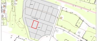
- Boundary points of the land plot;
- Structures erected on the site.
The information obtained during the topographic survey is summarized, analyzed and displayed in the form of a site plan .
In general it looks like this:
topographic survey of a land plot and get acquainted with its key elements in more detail
.
Where to get a situation plan for gasification
In order to ensure gas supply to a home, gas supply services must be provided with a situational plan linked to the territory on A4 paper. Contact the gas service at your place of residence - they will explain which organization should issue a situation plan for your specific area.
To apply, you only need the exact coordinates of the site. If there are no such coordinates, then there are two more ways:
- Seek help from a specialized architectural organization that can take spot measurements and draw up a plan on a scale of 1:2000;
- Make a situational plan yourself. You can take, for example, high-resolution satellite images as a basis. We will return to the question of how to draw up a situational plan of a land plot for free. However, I recommend that you notify the organization for which you intend to prepare the document in advance of your intention to compile it yourself.
Description of the procedure
The assessment of the terrain required to draw up a topoplan is a labor-intensive process consisting of certain stages.
To carry out such studies of the area, you should attract a qualified specialist from a geodetic company who has knowledge and experience and has the equipment necessary to carry out measurements.
Who does the topographic survey
On-site measurements are taken by a cadastral engineer who has the appropriate certification.
A non-specialist will not be able to perform such work: topographic survey requires
special skills and knowledge .
In addition, the engineer must be able to use:
- Navigators operating in the GPS system;
- Electronic tacheometers;
- Special flying devices that allow shooting from a height.
In addition, modern topographic surveys involve the use of satellite measurements.
You can order a topographic survey of a land plot from any company accredited for such work .
In this case, measurements must be carried out taking into account the provisions of the following regulations:
- Town Planning Code of the Russian Federation.
- Orders No. 518 and No. 582, issued by the Ministry of Economic Development.
- Federal Law No. 221.
- SP No. 11-106-97.
- SNiP No. 11-04-2003
The application is submitted directly at the office of the geodetic company, or online, in the form of an electronic request via the Internet.
select a suitable organization taking into account the location of the land plot on the following online sites:
- https://geosync.ru, which is a detailed catalog of geodetic organizations operating in the Russian Federation with convenient search by region.
- https://www.geotop.ru/catalogue.phtml, which allows you to get acquainted with the most popular land management companies in the regions of the country.
Having selected the desired organization, you can leave a request on its official website to perform topographic work on the site.
Preparatory stage
Topographic survey of a land plot begins with the conclusion of an agreement between the owner of the land plot and the selected contractor. The agreement specifies the full scope of work, as well as the timing and cost of their implementation.
Before proceeding with direct measurements of the territory, specialists from the selected company draw up a technical work plan.
Document paragraphs are formed based on :
- Customer wishes;
- Data from archival documents,
- Information contained in existing topographic maps of the area, including building plans.
In accordance with the information received, the scale of the future site plan is selected , and the need to use one or another type of tool is identified.
An important part of the preparation is obtaining permission to conduct filming from the territorial department of the Department of Architecture and Urban Planning.
If the procedure is carried out as part of land surveying, then the preparatory measures also include notifying the owners of plots located in the vicinity of the plot being studied.
Work on the ground
After approval of the technical plan by both parties to the agreement, a date is set for the cadastral engineer to visit the area to carry out direct work on measuring the site.
The general activities carried out directly on the territory of the land plot include :
- Determination of allotment coordinates.
- Creation of a geodetic network.
- Fixing specified coordinate points on the ground using special signs.
- Geodetic measurements of the territory.
- Search and survey of utilities located on the territory.
Depending on the purpose of the topographic survey, these actions may be supplemented .
For example, when ordering work for the subsequent construction of structures, cadastral engineers must not only display objects and terrain features on the plan in a general form, but also plan the verticals and horizontals of the future construction site and the required volume of earthworks.
Planning
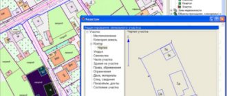
The data obtained during the topographic survey is recorded by cadastral engineers on electronic media.
After completing the work, they transfer this data to the office department , which is directly involved in drawing up a plan of the territory.
All objects discovered on the territory, linked to specific coordinates, are placed on a map , the scale of which is agreed upon in advance with the customer before the start of work.
In essence, a topographic plan is a digital model of a land plot , which is also subsequently transferred to paper. It is included in the technical report as a graphical part.
Then text paragraphs of the document are generated containing basic information about the site, an expert’s opinion, as well as information about the organization performing the work and the deadline for its completion.
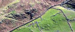
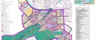
Topography and site plan
The most important designations on a topographic survey are the outlines of buildings.
Placing a structure on a plan records its existence at a given point in time and provides evidence in the event of litigation about the status and period of existence of the structure. The nature of the structure is indicated by a code in which the letter “Zh” refers to residential buildings, and the letter “N” to non-residential buildings. The symbols provide signs and codes for wooden buildings. These detailed lists of symbols are intended to cover the topography of any object that can be classified. When topographically surveying a separate area, the specialist must include on the plan all buildings, including wooden ones, such as barns, sheds, toilets, sheds, etc.
We recommend that you read:
Symbols on topographic maps
These objects affect the inventory value of home ownership.
Using the symbols on a topographic survey, you can determine the correspondence of real objects to their contours on the plans. Outdated plans may contain objects that no longer exist in reality, or there may be no objects built after the plan was drawn up.
Thanks to topography, it is possible to establish such characteristics of a building as:
- coordinates;
- dimensions;
- material;
- appointment.
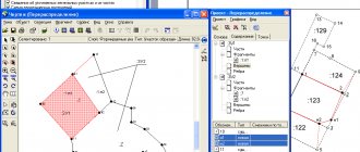
Formation of a plan based on theodolite survey data
Surveying using a special device for measuring vertical and horizontal angles - a theodolite, with the simultaneous use of various lengths (roulette or tape), allows you to obtain a contour plan of the territory .
Typically, the formation of a plan based on theodolite measurement data is carried out when it is necessary to obtain a situational plan for a relatively flat area on a large scale.
is used :
- In populated areas;
- At construction sites;
- On highways or when measuring agricultural land.
Such work helps to result in a special plan - a situation, with a detailed designation of all the objects available on the site.
Peculiarities
The basis of the measurements is a system of theodolite traverses, which are lines folded into polygons. Measuring their lengths, as well as rotation angles, allows you to draw up a situational picture of the area.
There are
several methods used when conducting theodolite surveys:
- Perpendiculars;
- Svorov;
- Linear serif;
- Polar coordinates;
- Corner serif.
The choice of a specific method depends on the characteristics of the measured area .
A feature of this type of survey is the need to measure all objects located on the site. In this case, the relief is not taken into account: if necessary, its image is additionally leveled.
Construction
The results of measurement work carried out during theodolite survey are transferred to the outline. This name means a drawing or diagram with records of angular and linear measurements .
Drawing up a plan begins with drawing a coordinate grid. It looks like a series of digitized lines drawn horizontally and vertically.
Then the coordinates of the vertices of theodolite traverses are calculated and plotted on the existing grid. In accordance with them, the situation obtained during measurements on the ground is drawn.
Methods of applying natural and artificial objects
All terrain objects are displayed on the plan compiled during the theodolite survey. However, in accordance with the accepted system of symbols, the designation of artificial and natural objects differs.
Clear outlines are used to display man-made structures . Similar lines indicate:
- Capital buildings;
- Fences;
- Wells;
- Other terrain features with clearly identifiable boundaries.
Natural objects are indicated using fuzzy outlines .
Similarly, the plan displays:
- Plowland boundaries;
- Contours of the forest;
- Crossing dirt roads or paths;
- Edges of rivers and other water bodies.
This designation is explained by the constant variability of the boundaries of natural objects .
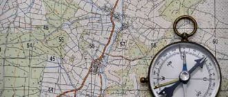
How to choose a card depending on your tasks?
Topographic maps are a type of geographical map. They carry detailed information about the layout of the area, indicating the location of various technical and natural objects relative to each other.
Working with a topographic map is not difficult, the main thing is to know where to start and what you need to pay attention to. This helps solve any problems related to obtaining the necessary information about the area.
Topographic maps vary in scope. All of them carry less or more detailed information about the area, so depending on the tasks at hand, you need to choose the right map.
The map scale is indicated on the side or bottom of the map. It shows the ratio of sizes: indicated on the map to natural. Thus, the larger the denominator, the less detailed the material. Let's say a 1:10000 map will have 100 meters in 1 centimeter. To find out the distance in meters between objects, use a ruler to measure the segment between two points and multiply by the second indicator.
- The most detailed is the topographic plan, its scale is 1:5000 inclusive. It is not considered a map, and is not as accurate, since it does not take into account the assumption that the Earth is round. This somewhat distorts its information content, however, the plan is indispensable when depicting cultural, everyday and economic objects. In addition, the plan can also show micro-objects that are difficult to find on the map (for example, vegetation and soil, the contours of which are too small to be depicted in other materials).
- Topographic maps at a scale of 1:10000 and 1:25000 are considered the most detailed among maps. They are used for household needs. They depict populated areas, industrial and agricultural sites, roads, hydrographic networks, swamps, fences, boundaries, etc. Such maps are most often used to obtain information about areas that do not have significant forest cover. They depict business objects most reliably.
- Maps with a scale of 1:50000 and 1:100000 are less detailed. They schematically depict the contours of forests and other large objects, the image of which does not require much detail. Such maps are convenient to use for air navigation, drawing up road routes and so on.
- Less detailed maps are used for military purposes to carry out assigned tasks for planning various operations.
- Maps with a scale of up to 1:1000000 allow you to correctly assess the overall picture of the area.
Having decided on the task at hand, choosing a material seems to be an absolutely simple task. Depending on how detailed information about the area is needed, the required map scale is selected.
How to make a topographic survey yourself
An accurate assessment of the area can only be made by a certified specialist who has a set of expensive measuring equipment.
Only a plan drawn up, certified in accordance with the requirements of the law, will be considered an official document confirming the conduct of land management work.
However, for your own needs, you can use a land plot plan drawn up with your own hands. It allows you to make the calculations necessary for minor changes in the appearance of the site, for example, laying paths or creating artificial reservoirs.
Required Tools
The set of tools required for taking measurements is quite simple. To carry out your own topographic survey you will need :
- Heavy hammer.
- 1.5 meter wooden stakes.
- Construction level or laser pointer.
- A tape measure designed for at least 30 meters.
- Long ropes.
It should be remembered that the results obtained using such tools are approximate and it is impossible to build capital structures based on them.
Order of conduct
Prepared wooden poles are installed at base points, which are the corners of the site. A rope is stretched between them, which should not sag.
The attachment point is located at a height of a meter from the earth's surface. You can determine the exact position using a building level. Next, use a tape measure to measure the distance from the ground to the stretched rope and record the results on the terrain drawing.
The next step is to compare the results obtained with a specific site plan, which can be downloaded from the Rosreestr website. It is important to take into account the scale of your own drawing and the official map.
Objects that are planned to be built must be located taking into account the red lines.
How to draw up a situational plan of a land plot yourself
Step 1 - download the SAS.Planet program
On the website https://sasgis.ru/sasplaneta/ download the SAS.Planet program for free. With its help, you can pull almost any cartographic and satellite maps from the Internet in the form of source data. Since data sources are constantly updated, in addition to the installation file, you will have to download and install ZMP packages that ensure stable operation with updates to open data sources.
Step 2 - setting up and selecting a map source
SAS.Planet makes it possible to save any section of a satellite image into a file with the resolution required for the situational plan. For the resulting snapshot file, there are several binding options for MapInfo. The public cadastral map of RosReestr can be obtained with a resolution of 3-5 cm per pixel.
But you need to keep in mind that all sources of maps on the Internet (Yandex, Google, 2GIS, RosReestr) produce a raster exclusively in the transverse Mercator projection, and a cadastral map is a local coordinate system in the Gauss-Kruger projection with an exact indication of the central meridian and displacements along north-east. Therefore, for small areas of the situational plan, you can use manual snapping and rotate the image by a small angle without raster transformation. This will give some error, which can be corrected based on the results of geodetic surveying on the ground.
Step 3 - Raster Transformation in GlobalMapper
To avoid geodetic surveying, you can use precise mathematical referencing. Then a high-resolution raster will provide an accuracy of 0.5-2 meters on the plain and 3-5 m on rough terrain. To do this, you will need to transform the raster using the georeference file obtained from SAS in the GlobalMapper program.
Using a datum (PRJ), you can obtain a correctly transformed raster with an accurate georeference file already in the local coordinate system, and then load it into MapInfo. In this case, it becomes possible to even detect gross errors in geodetic surveying.
Validity of results
It is widely believed that topographic survey results are valid for 2 years , as reported in paragraphs 189-199 of SP 11-104-97. However, it is a mistake to assume that the validity of topographic survey results is tied to a specific time frame.
Even after 2 years, with minor changes in the area, it is not necessary to carry out the work again : it is enough for the surveyors to sign an Act on the reliability of the information already available.
On the other hand, even a recently conducted topographic survey can quickly become unreliable. A similar situation is observed when the relief changes sharply by more than 35% .
Accordingly, the measurement results will be invalid and the procedure will have to be re-initiated.