In a general understanding, geodesy of a land plot is complex of measuring works, allowing you to determine the size and shape of the plot, analyze existing objects, soil structure and underground communications.
As a result of modern geodetic research, a three-dimensional coordinate system , which subsequently allows you to see a mathematical model of a specific area.
The main goals of geodetic work
Geodesy of a land plot is necessary not only in the case of construction work, since the scope of practical application of research results is much wider.
It is worth noting that land surveying is required in the following cases :
- Land surveying
- Cadastral registration
- Merger or division of plots
- Imposing new boundaries
- Sale/purchase of land
- Registration of ownerless land by allotment
As you can see, geodetic work is generally required in almost any legal transaction with land. Such procedures are performed primarily to obtain specific data and bring them into accordance with the general topographic plan of the area.
Site geodesy is used not only for lands intended for individual housing construction, but also for others belonging to different categories: for farming, recreational resources, and so on.
You need to understand that land geodesy is one of the stages of cadastral work, before which there is preliminary planning, and after that there is desk processing of the received data.
Laws and orders
All geodetic work on the ground is carried out in strict accordance with the requirements set out in regulatory documents, the main ones being the following :
- Federal Law 122-FZ “On State Registration of Rights”
- SP 47.13330.2012 Engineering surveys for construction. Basic provisions. Updated version of SNiP 11-02-96
- SNiP 11-04-2003 “Instructions on the procedure for development, coordination, examination and approval of urban planning documentation”
- Order of the Ministry of Economic Development of the Russian Federation on approval of types of boundary signs No. 582 dated December 31, 2009; Order of the Ministry of Economic Development of the Russian Federation (Requirements) No. 518 dated August 17, 2012.
Work on land geodesy should only be carried out by specialists who have the appropriate education and work in a licensed company .
Only in this case, the results of measurements and research can be formalized in the form of documents that have full legal force.
What does geodesy study?
Modern geodesy is a multifaceted industry that develops as a result of scientific and educational relations, production and technological processes between individuals and legal entities, government agencies and various organizations dealing with issues related to the study and use of the earth's surface in various directions and mandatory geodetic control.
The subject of study of geodetic science is:
- the shapes of the Earth, with periodic determinations of their sizes;
- the physical surface of the Earth with measurements taken on it;
- geodynamic processes occurring in the earth's surface;
- determination of the action of the Earth's gravity at its different points;
- establishing points and reference systems, coordinates for the entire territory of the state and the planet, required for a single spatial position in order to solve systemic planetary problems of a multifaceted nature;
- mathematical methods for constructing geodetic networks to form the unity of coordinate systems on the earth's surface;
- physical and mathematical methods of geodetic measurements;
- mathematical methods for processing field measurements and their theoretical equalization calculations.
Features of geodetic surveying
All the work performed by surveyors can be divided into several stages, following one after another:
- Topographic survey . Here, a specialist goes to the site to inspect the site, takes soil samples, determines the presence of groundwater and makes topographic measurements.
- Geodetic works . In the territory where research is being carried out, underground and above-ground communications may be located, including electricity supply, heating mains, telephone and Internet cables, and others. In addition, at this stage of the work, slopes and elevation changes are determined, and recommendations are provided regarding the location of future buildings along the cardinal directions.
- Work to coordinate the identified underground communications with the relevant utilities.
- Engineering and geological activities . Here, a thorough study of the soil is carried out both on the ground and in laboratory conditions. Based on the calculation, a written conclusion is provided regarding the bearing capacity of the soil in the study area.
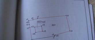
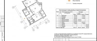
- Drawing up a boundary plan . The creation of a plan involves the drawing of actual boundary marks on the site, which makes it possible to determine its actual boundaries with high accuracy.
- Reviewing the design of the future building and comparing it with the results obtained to check compliance. If necessary, adjustments and amendments are made, valuable recommendations are given regarding the depth and type of foundation, and the exact location of the house.
Work on the geology of a land plot is usually carried out by a team of several people, which includes a cartographic engineer, a topography specialist and a surveyor.
Geosurveying of a land plot is the basis for a wide variety of construction, architectural and cadastral works . Satellite imaging has the highest measurement accuracy.
Scope of work on land plot geodesy:
- Research of landscape features of the area
- Determination of the exact boundaries of the land plot, which is revealed as a result of land surveying
- Identifying turning points
- Analysis of located communications (including abandoned – unmaintained)
- Photography of construction projects located on the site
In terms of time, all geodetic work usually takes about 3-4 weeks , but everything depends on the area of the plot, time of year, weather conditions, and so on.
Surveying Tools
When working on sites, surveyors use specialized tools. With their help, accurate calculations are made, measurements are taken in compliance with the required scale.
Such tools include:
- A level is a device used to measure points on an object during construction.
- A total station is a tool for measuring the heights and angles of points in space. Often an electronic device is used that stores information and then sends it to a computer.
- A theodolite is a device for measuring angles. It can be optical and electronic. In order to install it securely, you must have a special tripod.
Geodetic work is a method of precise design. Their task is to bring the structure to life as accurately as possible. All measurements are entered into special geodetic documentation, which is maintained from the moment construction begins until the stage of putting the structure into operation.
Registration and registration with government agencies
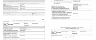
According to the requirements for geodetic work, the research results must be documented in the form of conclusions . They must be registered with the Architectural Bureau at the location of the shooting, before they are approved.
Scheme of work of the geodetic organization:
A company providing surveying and research services must have the appropriate license to perform such work. Only in this case can their conclusions undergo all approval procedures and be registered with the relevant authorities.
Interaction between the customer and the company is carried out on the basis of a written contract for the provision of services .
On average, the following stages :
- Conclusion of an agreement
- Departure of a team of surveyors to carry out work on the ground
- Performing surveys using special equipment
- Drawing a topographic map of the site
- Presentation of the results obtained in writing
- Payment and transfer of results to the customer
- Work on coordinating geodetic surveys
The sequence and stages can be adjusted depending on the specific conditions, goals and objectives of the customer, so the diagram is approximate.
Types of geodesy
Geodetic work is divided into several types. Each of them is responsible for a certain category of measurements and surveys.
Types of geodetic work:
- Topography is a description of the earth's surface. This type is engaged in surveying of various scales, updating topographic maps and plans, surveying utilities, underground and above-ground buildings. When conducting a survey, a mandatory requirement is the use of established scales and compliance with them. It is necessary to carry out such work during the construction of high-rise buildings, if it is necessary to carry out redevelopment, reconstruction of large-scale engineering and technical structures, and carry out work on landscaping parts of the city. The most accurate scale is used for measurements in populated areas, when planning the construction of a highway, transport interchanges, and large industrial production companies.
- Engineering or practical geodesy is a set of works consisting of studying and surveying the terrain in the area where construction is proposed.
- Hydrography is a type of work that deals with the description of water space.
- Staking work is a type of activity of surveyors, which involves the placement of specialized signs for reference to the state geodetic network. These signs are placed and maintained until the completion of all construction. This allows you to control the quality of construction work. When carrying out marking work, drawings are drawn that are linked to the actual terrain. After drawing up the drawings, the actual production takes place. To do this, key points are fixed directly on the ground. The results of the work performed are sent to the design surveyors with all graphs and drawings.
- As-built surveys are work that is carried out until the completion of construction. With the help of surveys, you can control the order of construction of the building and compare it with the planned drawings. Increased attention is directed to that part of the object that is the load-bearing one and the main focus of the entire structure. In other words, this part of the building or structure completely ensures the stability of the entire structure. All possible deviations that arise during the period of work are compared with the established rules and regulations of GOST. Based on the results of the filming, acceptance certificates are drawn up.
- Control over the deformation of structures - this type of measures is carried out not only at the construction stages, but also after its completion. Monitoring is carried out during the laying of the foundation, and so on every five floors. At the end of construction, a control inspection is carried out, and then an operational inspection. The shrinkage of the building, the flexibility of structures and individual parts of the entire monolith are controlled. In addition, surveyors conduct research into how the erected building affects nearby buildings and structures.
- Surveying underground networks - there are many factors that can influence the shrinkage of a constructed building. It is impossible to predict them all. In this regard, it is necessary to constantly measure the condition of underground networks. This type of control is carried out using photography, which records the position of all communication networks, drainage, wells and sewers. The results of such a study are the drawing up of a situational plan.
In addition to the above types of work, surveying work, which deals with measurements during the construction of tunnels, underground roads, and structures in the mining industry, will stand out. Geodesy also deals with cadastral work, which citizens who have a plot of land have to deal with.
It is very important to remember that when ordering work, you need to take into account the level of skill and experience of the surveyor. If the company is not well-known or has negative reviews, you should not contact this organization, as there is a high probability that the work will be carried out poorly. As proof of professionalism, you can ask the surveyor or geodetic service employee to show a document confirming his qualifications. Geodetic work must be carried out by a qualified specialist.
We recommend that you read:
What kind of work is carried out during engineering and construction surveys?