Home / Real estate / Land / Cadastral registration / Cadastral number / Information about land by cadastral number
Back
Published: 06/30/2017
Reading time: 6 min
0
1558
The coordinates of a parcel of land are the latitude and longitude of each of its turning points. The location of these points (corners of the site) is recorded in the cadastre. Thanks to the availability of exact coordinates, it becomes possible to mark the land on the Public Map of Rosreestr.
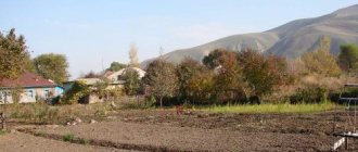
There are often cases when a citizen is informed only of the cadastral number of a land plot. The recipient of the land does not have the opportunity to see the plot in situ.
- Map with search
- Rosreestr website
- Google as a converter
- Extract from the Unified State Register of Real Estate
What is it needed for?
Each land property must be registered in the Unified State Register of Real Estate , where it is assigned an individual cadastral number. For this procedure, the owner must provide a package of documents, including a cadastral plan of the land plot.
Without a document it is impossible to carry out transactions with land:
- registration of encumbrances (how to find out the presence of encumbrances by cadastral number?);
- acquisition;
- sale;
- transfer of rights by gift;
- rental.
The cadastral plan is the basis for state registration of real estate. The status of the memory and its characteristics, for example, cost, depend on the correctness of its preparation.
The functions of a document depend on its type:
- The boundary plan consists of two blocks: text and graphic. It is necessary to register the land in the cadastral register and assign it a service cadastre number. The paper is drawn up during land redistribution: separation or unification of territory, adjustment of boundaries and errors made in official documentation.
- The technical map also consists of two parts. The graphic part contains diagrams and drawings, and the text part contains the characteristics of the memory and information about its location.
- In the derived map you can find information about the territory as a whole, indicating social, natural and economic processes.
- The public plan is posted on the Internet so that everyone has the opportunity to find information about the land plot at its address.
- The duty card reflects data on the territorial zone of the storage facility's location. The information is presented in the form of diagrams and text blocks.
Where can I see the boundaries of a land plot?
Online way to obtain information
You can determine the previously established boundaries of a land plot (LP) registered with the cadastral register on the website. This is done as follows:
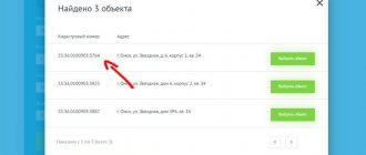
- Find the area you need on the map.
- Or having a cadastral number/address, etc. In the upper left part of the screen, select the “Magnifying glass” tool and then “Plots” - enter the cadastral number in the field that appears and click the “Find” button.
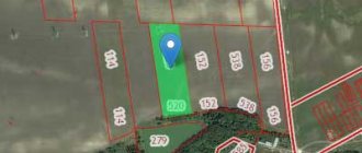
This is what your borders will look like:
If disputes arise with your neighbors, you can show them a screenshot of the boundaries indicated on the map. You can also use them as an appendix to the rest of the documentation defining the boundaries. But this information also does not have independent legal force.
If the plot is not registered with the cadastral register, online information will not be provided. The same applies if they are not included in the current program.
If you want to expand the boundaries with the help of clarification, then our other material will contain useful information for you.
Study the available documentation for the memory
If the owner or other title holder of the land has drawn up documents for the land in good faith, then they can contain information about the boundaries of the land plot. Such documents include:
- certificate of the form of right to land plot;
- cadastral passport of the land plot;
- land surveying;
- other cadastral documentation.
Copies of these documents and their originals are fully legal to resolve land disputes, including in court, and determine red lines before the start of construction.
The main documents are the papers drawn up by the cadastral engineer during land surveying:
- the act of agreeing on boundaries with neighbors;
- act of transfer of boundary marks;
- cadastral plan of the land plot.
Act of approval of the boundaries of a land plot: form, sample filling.
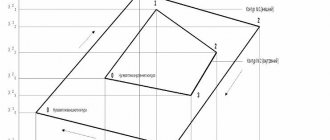
Example of a cadastral plan for a land plot
From them you can obtain completely reliable and legal information to resolve all issues related to the passage of boundary boundaries.
How to find out the boundaries of your land plot in Rosreestr?
If the cadastral passport was received more than three years ago, or at the request of the authorized authority, a cadastral extract indicating the coordinates of the turning points is presented. This information is received by the State Real Estate Cadastre (GKN) in accordance with the Federal Law adopted on July 24, 2007 under No. 221-FZ.
To obtain it you need:
- Go to the cadastral office or multifunctional center (MFC) at the location of the plot.
- Get an electronic queue coupon. It is permissible to make an appointment in advance by filling out an application on the government services website.
- Pay a state fee of 200 rubles.
- According to the coupon or registration time, go to the registrar window and write an application for the issuance of information about the location of the boundaries of the storage area.
- Present your civil passport and certificate of ownership of the land plot.
- After 5 working days, come for a follow-up appointment and receive the completed document.
The resulting extract will contain current and legal information about the boundaries of the allotment. But if the boundary of the land plot has not been established earlier, the extract will indicate that the boundaries of the plot at the corresponding address have not been established.
Unlike information posted on the website in the public domain, information from the State Property Committee is not disclosed to third parties.
Sample cadastral extract about land plot
What does a plan map look like and how to read it?
The cadastral plan of the land plot is located on several sheets. On the first you can find the main characteristics of the land:
- number from the USRN (how to find out the number via the Internet?);
- location or address of the storage unit (can you find out the address by the cadastral number?);
- category to which the land is classified (how to determine the category of land by cadastral number?);
- type of use of the site;
- date of registration of the object;
- storage area (read how to find out the storage area by number in the cadastre?).
Information about the author of the document and his contacts is also provided here. On the next page there is a map of the area with the site configuration and turning points. Linking to neighboring plots is carried out to avoid overlapping boundaries. Information about encumbrances is entered only if they exist. The remaining sheets contain explanations for the first two sections.
The design lines on the cadastral plan correspond to the boundaries of the plot and are a symbol. Particular attention should be paid to the red lines that indicate the existing boundaries of territories and have legal force. They may appear on the updated scheme due to the appearance of a highway or other elements, as well as in the event of detection of illegal redevelopment.
What a land plot plan looks like is described in more detail in this material.
Online
In addition to the possibility of using a public cadastral map, it is possible to obtain information about a land plot by contacting specialists online. To do this, an electronic request is made on the official website of Rosreestr or on the State Services portal.
The document will also be provided in electronic form . The state duty for this service is 150 rubles for individuals, 300 rubles for legal entities.
You also need to provide scans of the remaining documents listed in the previous section.
Search via PKK
In order to find out the size of a land plot, having an address, coordinates or cadastral number, you can use the capabilities of the Public Cadastral Map of Rosreestr. This is a unique online service, using which an interested person can obtain all the necessary information about the requested object .
This web application is located on the official page of Rosreestr https://pkk5.rosreestr.ru.
In the search window, which is located in the upper left corner of the map, you need to select the “Plots” subsection and enter the cadastral number of the land plot.
By clicking the “Find” button, the user will see that the map in auto mode will find and show the boundaries of the storage area in yellow, and in the adjacent window that appears, information about the object will appear, including the area defined in square meters.
The “Zap plan” option will help you save a drawing of the site.
If data about the site is not available on the PKK or the message “Without border coordinates” is displayed, then in the help window you need to contact a cadastral engineer to clarify the necessary parameters of the site.
In the process of executing the request, the dimensions and area of the plot will be clarified and provided to the user.
The dimensions of the area on the interactive map can be taken manually using the “Measurements” item in the left menu of the map. Next, without releasing the right mouse button, you need to mark the boundary line that needs to be measured. The result will be displayed under the “Measurements” button.
How to find according to the cadastral plan
A cadastral plan (passport) of a land plot is a document with legal force, which reflects data on the characteristics of a particular land plot.
The cadastral plan can be obtained on paper or electronic media through Rosreestr or MFC through an official request.
It is divided into 5 separate specific parts.
Each of these parts displays a specific type and type of site data.
The first section is devoted directly to information about the land:
- Assigning a cadastre number to the plan and site;
- Coordinates and address of the land plot, area, boundaries and other physical characteristics of the territory;
- Date of creation of the passport, date of entering detailed information about the object;
- The authorized body by which the registration was carried out;
- Data on entities authorized to conduct operations with the site.
The second section is a plan diagram of the territory on which the plan was drawn up, with a detailed description of its boundaries.
The third section contains information in the form of text about the reasons for placing the described site in a specific territory, and also mentions neighboring land plots.
The fourth and fifth sections clarify information about the objects located on the site.
Where and how to get it?
To obtain a cadastral plan, you need to contact the MFC or Rosreestr. You can visit the organization’s office in person by taking a paper form from an employee and entering the name of the sender and recipient, storage data, purpose of receipt, and the required number of copies of the document. The finished plan can be picked up after 5 days if you contact Rosreestr and after 5 days - at the MFC, upon presentation of your passport and receipt of payment of the state duty for each copy.
The application can also be submitted through the website https://rosreestr.ru/. You can find it at the link https://rosreestr.ru/wps/portal/p/cc_present/EGRN_6. Any interested person has the right to submit a request for a copy of the document. We talked about how to get a cadastral plan by number online here.
Reference! The price of the paper version of the cadastral plan is 800 rubles. for individuals and 2400 rub. for YUL. The cost of a document in electronic form is 150 rubles. for individuals and 300 rub. for YUL.
Every land owner has to deal with a cadastral plan. Without it, it is impossible to legally complete any real estate transaction. Obtaining a document is simple - just contact the MFC or Rosreestr, fill out an application and pay the state fee.
Rosreestr website
Unfortunately, the Public Map on the Rosreestr website will not be able to tell you the exact coordinates. This functionality is not included in it. But it is possible to determine the coordinates with some degree of error.
Step 1. Open the map and find a button with a magnifying glass on the left. It is usually at the very top of the menu. Click on the magnifying glass and get a search bar. By default, it is intended specifically for searching for land plots.
Step 2. In the search field, enter the cadastral number known to us. In our example it will be .54:20:022620:16. We press the blue “Find” button and immediately get the area we need. It is marked in yellow.
Step 3. Zoom in as much as possible by clicking on the plus sign in the bottom right menu several times. This will reduce the final error.
Step 4. Gently click on the right corner of the area with the cursor. Please note that the numbers in the search string have changed. These are the desired coordinates of the point.
Step 5: Repeat for the remaining three points. To do this, you may have to move the map while holding down the left mouse button.
What method do you use to obtain the coordinates and address of a plot by cadastral number?
I go to the Rosreestr website. I look at the Unified State Register of Registration (USRNS) extract. I’ll write my answer in the comments.
How to find out the coordinates of the site?
Often the citizen is only informed of the cadastral number of the land plot. To find out the coordinates of the boundaries of a land plot or the size of the plot by coordinates, you need to go to the website of the public cadastral map. It has a number of tools:
- Search for objects
- Objects at a point
- Card management
- Drawing
- Measurements
- Favorites
- Print map
- Background information
- Feedback
Using them, you can find out various data about the site. Such as GPS coordinates of the site, length of the site by coordinates and many others.
Additional functions of the public cadastral map
Good to know! Cadastral map developers provide the opportunity for smartphone users to download an application for a mobile device or tablet. It has the same functions as the “full-fledged” program, but is adapted for use on smartphones.
The public cadastral map has convenient tools that make spatial search for a given land plot much easier. For example, it is possible to calculate the area and determine the distance between points. For ease of use, you can save the information found in Excel format.