First, let's define the concepts:
- A topographic map is a map that contains complete information about the relief, location of water bodies, soils and vegetation.
- A topographic plan is a large-scale drawing with symbols depicting a specific territory.
Using a topographical plan of the area and a map, you can display the relief and identify objects for various purposes.
Definition
Let's start the article with definitions:
- A topographic plan is a document that is drawn up based on the results of a topographic survey of the area. This is the name of a drawing of elements of a situation, relief, as well as other objects on the ground with their technical and metric characteristics, which is executed using approved symbols.
- A topographic plan is a type of large-scale drawing that depicts any section of the earth's surface on a plane in conventional symbols. It is constructed without taking into account the curvature of the level surface. Here, a constant scale is maintained in all directions and at any point.
The main feature of the topographic plan is its altitude component. That is, at any point in the image you can determine the height of the object drawn there. In addition, on a topoplan you can measure linear parameters and coordinates of objects (taking into account the scale).
All of the above data can be easily obtained on both paper and electronic versions of the plan. Thus, a topographic plan is not only a visual representation of a certain area, but also a starting point for modeling and design.
Reading sequence
Reading a map makes it possible to most competently and completely understand symbols and conventions, to recognize types of objects in a short time and without errors.
In addition to reading, it is important to visually perceive the relationship between objects located at a certain distance in space.
To gain such knowledge, you need to practice reading and draw out fragments with symbols. In addition, it is important to train on maps of different scales.
The following sequence is recommended for reading topographic maps and plans:
- Definition of scale.
- Search for various objects and identify their type, such as bridges, factories.
- Determining the location of communication and power lines, as well as other types of communications.
- Identification of vegetation using designations that allow one to determine the type of tree, its rarity or density, size and area occupied.
- Identification of hydrography, which includes rivers and lakes. Their characteristics are established.
- Definition of relief with its characteristics - the presence of mountains, slopes, cliffs and ravines.
- Relief detection when moving along a given route.
Difference from the map
How will the topographic plan of the site differ from the same map? These documents cannot be called identical. Map development involves the use of small scales. Maps are created to cover larger areas than topographic plans.
There is one more difference: when creating a map, the compiler takes into account the curvature of the surface of the globe, but when creating a plan, he does not. The latter is characterized by the use of large scales - from 1:5000 to 1:500.
In addition, the plan will differ in the depiction of the following objects:
- Terrain.
- Engineering and technical structures.
- Boundaries of available land.
- Availability of connected communications.
Also, the topoplan stands out not only with a graphical representation of existing objects, but also with detailed information about their parameters: elevation, quality and quantity.
Drawing up a document
Topographical plans of land plots are prepared by surveying engineers. To work in this niche, it is no longer enough to graduate from university, receive a diploma and purchase professional equipment for topographic surveys. The specialist must work in an organization that has membership in the relevant SRO (self-regulatory organization).
This regulation has been in force in the Russian Federation since 2009. Its introduction was due to the desire to increase the responsibility of surveyors and strengthen their preparedness.
All devices used by specialists undergo appropriate certification. They must have certificates of passing the necessary metrological checks. Processing of materials obtained from topographic surveys and measurements is carried out today using licensed specialized software.
Why are topoplans needed?
Why are conditional plans for topographic plans developed? In fact, this is a necessary pre-design document for the start of any construction. Let us indicate in which cases it is necessary:
- Obtaining documentation and construction permits.
- Design of work during the construction and reconstruction of buildings and structures. This also includes the design of communication lines and their reconstruction.
- Registration of ownership, lease of a newly formed land plot.
- Vertical layout of any territory.
- Landscape design on land plots.
Validity
To clarify the validity period, you should refer to the Code of Practice - SP 11-104-97 “Engineering and geodetic surveys for construction”. According to them, if the relief and contours of the area do not change, then the topographic survey data is valid for two years without confirmation. Then an “Act of Approval” is required.
If for some reason more than 35% of the relief has changed, then the topographic plan is subject to change, regardless of how long ago it was compiled.
Topographic survey not only displays the boundaries of land plots, but also fully shows the communications and objects available on it, as well as the distance between them, height and other quantitative data. Without this document, it is impossible to obtain permission for the construction or reconstruction of buildings. Topographical work is carried out by geodetic companies. The quality of the result directly depends on the accuracy of the equipment used.
We tried to write the best article. If you liked it, please share it with your friends or leave a comment below. Thank you! Great article 0
Required documents
If the customer of the topographic plan is an individual, then it is enough just to indicate the location of the required object (cadastral number or address of the site), and then verbally agree with the specialist on the need to carry out certain works.
In the case when a legal entity orders a service, it is necessary to draw up an agreement and an acceptance certificate. The customer must also provide the surveying company with the following documents:
- Situational plan of the required object.
- Terms of reference for carrying out geodetic and topographical work.
- Information about previously completed topographic work.
- Other documents that may contain cartographic information about this object.
Where to order a topographic plan - review of the TOP 3 geodetic companies
Companies involved in the development of topographic maps provide a range of services for as-built surveys and other types of surveys for construction and registration of land ownership.
When choosing a company, inquire about the work experience of the employees and look at examples of work performed. Any professional takes pride in a job well done.
An honest topographer has nothing to hide behind nomenclature.
1) Geotope Engineering
A company providing services in the field of geodesy, geology and cartography. Conducts engineering surveys for construction throughout the Moscow region . The company's main clients are individuals and budgetary enterprises.
On the company’s website you can order a free call and consult on any issue you are interested in, draw up a preliminary estimate and make an application to remove the boundaries of the land plot in kind.
The company constantly holds promotions for its work. You can get a discount on a topographic drawing of your site by simply contacting Geotop Engineering.
2) Sovzond
The largest Russian company in the geoinformation services sector. Founded in 1992, the company provides innovative approaches to the development of geoprojects. The focus of the company's work is modern technologies in geodesy.
Sovzond is implementing a partnership program, inviting companies operating in the field of geoinformatics to cooperate.
The company offers services:
- on the development of geographic information systems;
- satellite imagery of the territory;
- aerial photography;
- geomodelling;
- and much more.
Sovzond - objective information about the state of the world around us!
3) KadGeoBuro
A universal enterprise providing geodesy, topography, cadastral work and land surveying services. In their research, the company's employees use the most modern equipment and current work methods.
The company's flexible and open pricing policy attracts a wide variety of clients. Ordering is simple, fast and easy. One call or sending an application by e-mail is enough, and you will be pleasantly surprised by the professionalism of the company’s specialists.
The advantages of the organization include the full cycle of work carried out. All necessary measurements are carried out and the entire portfolio of documents related to land and property relations is drawn up.
"KadGeoBuro" - the highest measurement accuracy!
What does the plan look like?
Today, a topographic plan is not just a paper document. Its representation in the form of a DTM—a digital terrain model—is gaining popularity. You can also order a version of the plan in the popular PDF format.
But we must remember that few operating and controlling organizations have the ability to work with a document in this form and certify it with electronic signatures. Hence, for approval and affixing the necessary stamps, a printed version of the topoplan is needed.
About the scale on the plan
A topographic plan is a document drawn up on a scale from 1:10000 to 1:100. Depending on this, the accuracy of the depicted objects will also be different. For example, on a small scale it is almost impossible to depict trees or communications - they will merge into one spot.
In this area, there are also generalization rules: the smaller the scale, the larger and more significant objects should appear in the image.
The most popular scales regarding topographic plans are 1:500 and 1:1000. They are used in design and construction. Any such topoplan will consist of a drawing and other auxiliary images.
Accuracy
With the naked eye, a person can distinguish a segment of no more than 0.1 mm on the map. This means that the error, depending on the scale, is a distance equal to 0.1 mm on the map. For example, for a scale of 1:1000:
- 1 cm on the plan – 1000 cm in reality – 10 m;
- 1 mm on the plan – 1 m;
- 1 – 10 cm.
Therefore, for a plan with a scale of 1:1000, the permissible error is 10 cm.
Main graphic part
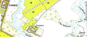
Let us now move on to the symbols for topographic plans. They are applicable specifically for the graphic part of the document. It is important to highlight the following groups:
- Relief. It is depicted using basic and thickened horizontal lines. They are supplemented by marks on the height of the area. The latter are indicated in format 111.22, in meters above sea level. Interestingly, in Russia the Baltic height system has been adopted, and only in the capital is the Moscow system used. It differs slightly from the first one - by +/-92 mm. Contour lines and marks allow you to judge the terrain - it is possible to identify pits, mountains, hollows, ridges, saddles, etc.
- Vegetation and soils. Signs of topographic plans necessarily “tell” about the views of both.
- Hydrography. Using symbols of topographic plans, rivers, lakes, swamps and streams are depicted. The name of the water body, the direction of its flow, depth and speed must be written down.
- Road network. Road, pedestrian, railway and tram routes are marked. Contains information about their coverage and width.
- Network engineering. Conventional signs for topographic plans 1:500 are designed to tell about underground and surface communications - power lines, gas pipelines, sewerage, water supply, communication lines, etc.
- Fencing. This is a display of all types of hedges, fences, etc.
- Structures and building. Such objects are provided with signatures describing their number of storeys, their belonging to the residential sector, and information about materials.
- Boundaries. Topographic plans must indicate the boundaries of settlements, cadastral limits of land plots, as well as the boundaries of the topographic survey itself.
Topographical survey for electrical connection
Topographic surveys for electrification are ordered when supplying electricity underground. For the air method, a situational plan is sufficient. Providing a topographical plan will protect you from any problems related to connecting to electricity, and from conflict situations with neighbors and the supply organization.
To connect to the power grid, topographic surveys are carried out and maps of the area are drawn up indicating the location of connection to the power supply network. The plan indicates all above-ground outbuildings that are planned to be electrified. A topoplan and situational plan are necessary to develop a power supply scheme for the site. The plan is drawn up on a scale of 1:500.
The document contains information about:
- boundaries of the site
- permanent and temporary buildings
- power lines
Typically, a plan for electrification is drawn up before building a house. It is part of the documentation for obtaining a construction permit and putting the house into operation.
Cost of topographic survey 1:500
| 1 plot | 3 hours | from 10,000 rub. |
| 2-5 plots | 1 day | from 8,000 rub. |
| 6-10 sections | 2-3 days | individually |
Order
Our company carries out topographical and geodetic work within 5 days to connect to utility networks. We have all the necessary permits and licenses, as well as verification of geodetic equipment. The work is carried out by surveyors with at least 5 years of experience. Equipment is used with an accuracy of 1 mm and higher. All work is carried out in compliance with legally established norms and SNiP regulations. Documents are drawn up and agreed upon in accordance with current legal requirements.
Auxiliary symbols
In the case of topographic plans, auxiliary images include the following:
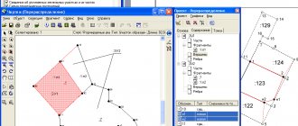
- Mathematical basis. That is, the image of crosses and the designation of their coordinates. This allows you to clearly link the drawing to coordinates on the real terrain.
- Conventions. If any symbols are used on the topoplan that are not related to generally accepted symbols, then they are deciphered on the drawing itself. If the document contains only standard characters, they are not decrypted.
- Main stamp. A place on the document where you can find all the additional information about the drawing - scale, location of the object, information about the artist, etc.
Necessary equipment
The preparation of a topographic plan of a land plot is preceded by a topographic survey. It requires the following equipment:
- Optical levels. Allows you to accurately measure the plane of the area.
- Electronic tacheometer. A high-precision device for measuring altitude parameters, determining rectangular and polar coordinates, measuring the area of land plots, and processing the obtained data.
- Rangefinders. Today these are laser electronic tape measures that allow you to quickly, accurately and effortlessly determine the distance between objects.
- Satellite equipment.
This concludes our acquaintance with the most important characteristics and features of topographic plans. You also now know how such documents differ from maps and geobases.