When is it necessary to remove site boundaries?
Laying out a plot, or setting out boundaries in situ, is topographical work that is often required by land owners when various disputes arise with neighbors. To resolve an existing conflict or avoid it, they turn to specialists - topographers. The engineer studies the available information about the disputed territory in the State Real Estate Cadastre (State Real Estate Cadastre) and breaks down the boundaries (installs special boundary markers) using special equipment.
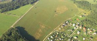
Also, taking out the site may be necessary when selling, purchasing a plot or concluding a long-term lease agreement. In this case, the work will allow the buyer (tenant) to determine the reliability of the data contained in the documents: from the point of view of assessing the area of the site, its location and real boundaries on the ground. It happens that the actual boundaries do not correspond to those indicated in the cadastral passport. This may arise due to unlawful actions of neighbors to seize someone else's territory (possibly not intentionally) or the loss of old boundary markers.
Removal of the boundaries of the site is also required before the construction of buildings, structures and permanent structures (including fences) on it. This will allow you to protect yourself from losses associated with the possible demolition of the object in court, for example, when these actions are challenged by neighbors).
Removing the boundaries of the site in nature is required:
- When clarifying the boundaries of adjacent territory with neighbors.
- Before the construction of buildings, structures and permanent structures begins.
- In the event that boundary signs installed earlier have been lost.
- When buying and selling a plot.
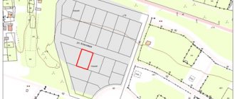
Setting out points, boundaries and land plots.
Dmitrov, Yakhroma, Abramtsevo, Autopolygon, Agafonikha, Akishevo, Akulovo, Alabukha, Aladino, Alexandrovo, Aleshino, Andreykovo, Andreyantsevo, Arbuzovo, Arevskoye, Arkhanovo, Assaurovo, Astretsovo, Afanasovo, Ashcherino, Babaikha, Babkino, Bazarovo, Banino, Batyushkovo, Bezborovo, Beklemishevo, Bely Rast, Bestuzhevo, Beshenkovo, Birlovo, Annunciation, Annunciation, Grace, Middle, Bobrovo, Bogdanovo, Bolshoye Prokoshevo, Borisovo, Bornosovo, Borodino, Bortnikovo, Bortsovo, Bunyatino, Buslavl, Bukharovo Station, Bykovo, Vaganovo, Vankovo , Varvarino, Vasilevo, Vasnevo, Vedernitsy, Vekshino, Verbilki Station, Vlaskovo, Vnukovo, Voldynskoye, Voronovo, Vysokovo, Gavrilkovo, Glazachevo, Glazovo, Glebezdovo, Glukhovo, Goveynovo, Golikovo, Golovino, Golyavino, Golyadi, Goncharovo, Gora, Gorbovo, Goritsy, Gorki, Gorki Sukharevskie, Gorki-25, Gorchakovo, Gorshkovo, Grigorkovo, Grishino, Gulnevo, Davydkovo, Danilikha, Rabochiy Dedenevo, Dedlovo, Demyanovo, Dmitrovka, Doronino, Drachevo, Drochevo, Dubrovki, Dubrovo, Dumino, Dutshevo, Dyakovo, Dyadkovo, Dyatlino, Elizavetino, Ermolino, Erykovo, Zhestylevo, Zhivotino, Zhirkovo, Zhukovka, Zhukovo, Zaramenye, Zverkovo, Zuevo, Ivanovskoye, Ivanovskoye village, Ivantsevo, Ivashevo, Ivlevo, Ignatovka, Ignatovo, Izmailovo, Worker Iksha, Ilyino, Ilyinskoye village , Isakovo, Kamenka, Kaporki, Karavaevo, Karamyshevo, Karpovo, Kartsevo, Kekishevo, Kikino, Kindyakovo, Klusovo, Klyushnikovo, Knyazhevo, Koveryanki, Kovrigino, Kolotilovo, Komarovka, Konchinino, Kopylovo, Kopytovo, Korgashino, Kosynka, Kostino, Kostyunino, Kochergi but , Kromino, Kruglino, Kuznetsovo, Kuzyaevo, Kulikovo, Kulpino, Kuminovo, Kunisnikovo, Kurovo, Kurkovo, Lavrovki, Levkovo, Lesnoy, Lipino, Lifanovo, Lishenino, Lotosovo, Lugovoy, Lukyanovo, Lupanovo, Lutkovo, Luchinskoye, Malaya Chernaya, Maloe Nasonovo , Maloe Rogachevo, Maloe Teleshovo, Malygino, Malye Dubrovki, Manshino, Marinino, Martynovo, Matveevo, Matveykovo, Medvedkovo, Melenki, Melikhovo, Melchevka, Mikishkino, Miklyaevo, Mineevo, Misinovo, Mitkino, Mikhailovskoye, Mikhalevo, Mikheevo-Sukharevo, Mishukovo, Morozovo, Motovilovo, Muravyevo, Mukhanki, Myshenki, Nadezhdino, Nadmoshe, Nazarovo, Nasadino, Nasonovo, Nastasino, Nepeino, Neroshchino, Nesterovo, Nestertsevo, Nefedikha, Nechaevo, Nizhnevo, Nikitino, Nikolskoye, Nikulino, Nikulskoye, Novinki, Novlyanka, New Grishino , Novoe Selo, Novoe Seltso, Novokartsevo, Novoselki, Novosinkovo, Noskovo, Ovsyannikovo, Ovchino, Ozeretskoe village, Olgovo, Olsovo, Olyavidovo, Orevo, Orudyevo, Ochevo, Panteleevo, Pankovo, Paramonovo, Peresvetovo, Sands, Petrakovo, Peshkovo, Pletenevo, Podvyaznovo, Podgornoye, Poddubki, Podmoshye, Podosinki, Podsosenye, Podcherkovo, Podyachevo, Pozdnyakovo, Pokrovskoye Selo, Popadyino, Popovka, Popovskoye, Postnikovo, Pokhodkino, Pritykino, Prudtsy, Ponds, Pulikha, Purikha, Pustyn, Pykhino, Ramensky, Ramenye, Revyakino . Sikhnevo, Skriplevo, Slobodishchevo, Sokolovsky Pochinok, Sokolniki, Sofrygino, Spas-Kamenka, Spiridovo, Kostino Station, Staro, Starovo, Stepanovo, Strekovo, Stupino, SU-847, Surmino, Sysoevo, Sychevki, Tatishchevo, Teleshovo, Tendikovo, Terehovo, Teryaevo, Tefanovo, Timonovo, Timofevo, Timoshkino, Titovo, Tishino, Torgovtsevo, Trekhdenevo, Troshcheikovo, Labor Station, Trunevki, Turbichevo, Tyutkovo, Udino, Ulyanki, Ust-Pristan, Fedorovka, Fedorovskoye, Fedotovo, Filimonovo, Fofanovo, Kharlamovo, Khvostovo , Khlyby, Khoroshilovo, Khoryakovo, Khrabrovo, Tseleevo, Chainikovo, Cheprino, Cherneevo, Cherny, Shabanovo, Shadrino, Shelepino, Shikhovo, Shukolovo, Shulepnikovo, Shulgino, Shustino, Shchepino, Shchetnevo, Eskino, Yurkino, Yuryevo, Yazykovo, Yakovlevo, Yakot , Yarovo.
What is required for the work?
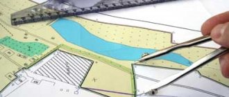
An important condition for starting work is preliminary land surveying. It is necessary that data on the coordinates of its turning points be entered into the state cadastre of real estate objects (GKN). They may also be contained in the boundary plan, on the basis of which the cadastral registration was carried out. However, in some cases they may differ, so it is better to use the current USRN extract.
If land surveying has been carried out on the territory, the surveyor receives a cadastral extract with the coordinates of turning points, which are required to map out the exact location of its boundaries on the ground and secure them with boundary signs. If land surveying has not been carried out previously, it is necessary to additionally carry out this work, since it is impossible to map out the boundaries of the land plot without this information.
IT IS IMPORTANT TO KNOW!
Before the breakdown, it is necessary to carry out land surveying - determining the coordinates of the site on the ground and entering them into the electronic database of the State Property Committee (state real estate cadastre).
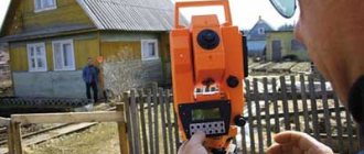
Setting out points using GPS equipment
At least two sets of geodetic equipment are used in the work. The main receiver (base) is installed at a point with known coordinates, and the auxiliary receiver (rover) moves around the site. Both receivers are equipped with a receiver, antenna, controller and GSM or UHF (VHF) modem for transmitting correction data from device to device online.
The calculated coordinates of the points are entered into the rover's memory. As it moves around the site, there is an active exchange of data with the “base”, and the device indicates to the engineer in which direction the receiver needs to be moved in order to be at a given point.
Features of the surrounding terrain can interfere with the satellite signal that GPS equipment is guided by, which can affect the accuracy of point determination, so this method is used primarily for determining coordinates with the possibility of error.
How accurate is the breakdown?
The process of drawing out the boundaries of the site begins with calculating the coordinates of the base points using a geodetic GPS receiver. After laying the basis, or geodetic justification, specialists move on to determining the geodetic coordinates of the points of the land plot, which are indicated in the cadastral extract. This work is carried out using a tacheometer.
When carrying out work on removing points, it is important to strictly comply with state standards. Thus, within a populated area, the required accuracy of determining coordinates is 10 cm, and for agricultural lands - 20 cm. At the same time, most modern geodetic equipment provides a breakdown accuracy of up to 5 cm. You should also additionally take into account the error when registering a site for cadastral registration. When performing land surveying (determining the coordinates of turning points), it can range from 10 to 30 cm.
Thanks to the use of modern equipment, the procedure for checking the boundaries of the site and installing boundary signs (if an extract is available) can be completed within a period of 1 day.
Accuracy of determining coordinates according to state standards:
- 10 cm - within a populated area.
- 20 cm - for agricultural land.
- 10 to 30 cm - additional error (when registering in cadastral register).
Who has the right to carry out boundary removal work?
Only employees of geodetic organizations or cadastral engineers can carry out the removal of boundaries. To accurately take the necessary measurements, a regular tape measure is not enough. To carry out work to determine and secure the boundaries of a land plot, geodetic equipment must be used. Therefore, this work can only be entrusted to a specialist knowledgeable in the field of geodesy and cadastre. A list of organizations can be found in the catalog of cadastral service providers. After all, factors such as the placement of buildings on the site in the future, installation of a fence, and planting of trees depend on correctly taken measurements. When registering ownership of buildings, a technical plan is drawn up, which indicates the connection of the house or other premises to the land, and if it turns out that the structure goes beyond the permitted limits, then the structure may be considered unauthorized and even required to be demolished. Therefore, in such a matter as removing boundaries, you should not skimp, but only contact qualified and proven specialists.
Types of boundary signs
If you plan to install a fence in the near future after the breakdown, you can use temporary boundary signs (rebar). However, please note that they can be easily destroyed or rearranged. Therefore, if the construction of capital structures on a site is postponed indefinitely, it is recommended to install long-term signs. In this case, a hole up to 1 meter deep is drilled, into which a metal pipe is laid (about 1.5 meters long and 80-120 mm in diameter). At the top there is a sign indicating the number of the boundary mark. At the same time, the cost of the work increases slightly, but such signs remain much longer.
Boundary signs are:
- Temporary (reinforcing bar).
- Long-term (concreted hole with metal pipe and sign).
Fixing the boundaries of a land plot on the ground
Why do you have to restore boundary signs? The fact is that the law does not oblige, when determining the boundaries and turning points of a site, to immediately install fundamental structures in the form of fences and enclosures. According to the instructions, boundary markers are either wooden pegs about 80 cm high or iron pins and pipes driven into the ground to a depth of about 40 cm. It is not surprising that such objects can easily be lost during construction or other work. But in order to restore the borders again, a specialist with geodetic equipment will be required. Boundaries are established according to the coordinates of the site, relative to geodetic points in the local coordinate system.
Can I do the breakdown myself?
In principle, it is possible to make a breakdown of the boundaries of the site yourself. This will also require preliminary land surveying and a cadastral extract indicating the coordinates of the reference points. Having some knowledge of geometry and a tape measure at least 20 m long, you can mark out the site, that is, transfer its configuration to the terrain. However, there are situations in which marking work is impossible without special instruments, for example, if the site has a complex geometric shape. A tape measure alone is not enough here. In addition, the owner of the site may encounter difficulties in determining the location of the site on the ground, especially if there is no fence, buildings or structures on it (this requires a modern GPS device). Therefore, to eliminate errors in breakdown and unplanned costs, it is better to entrust the work to a qualified expert who will carry out the survey using high-precision equipment.
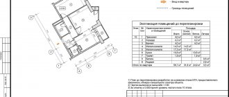
Transferring the project to the locality
Transferring the project to the site is one of the most important stages of any construction. Through marking work, specific points, marks and axes are marked and fixed on the land plot, which subsequently determine the compliance of the position of all elements and structures of the object with the design documentation. The accuracy of the implementation of design solutions is regulated by the project itself and generally accepted regulatory documentation.
The implementation of the project is carried out in several stages:
- creation of external and internal distribution networks;
- detailed breakdown: determination of the levels of design heights, breakdown of the longitudinal and transverse axes of the object (or objects);
- breakdown of technological axes of equipment.
There are several ways to transfer points of a design structure to the terrain:
- linear;
- direct angular notching method;
- rectangular and polar coordinates.
What determines the cost of the work?
The cost of carrying out these works largely depends on their volume: the number of points, determined by the configuration and size of the study area. Accordingly, the more points, the higher the cost. The price is also influenced by the customer’s requirements for the preparation of a Stakeout Certificate (simple, with a photo report or a diagram for linking boundary points) and the type of boundary signs (temporary or long-term). In addition, factors such as the location of the study area, the speed of work, etc. are taken into account. The cost of work will be higher if land surveying is additionally required before removing boundaries.
What affects the cost of work?
- Number of points, configuration and size of the site.
- Requirements for drawing up the Take-Out Certificate.
- Type of boundary signs.
- Site location.
- The need for additional work (land surveying, cadastral registration).
Cost and terms of work
The time frame for carrying out work to carry out the boundaries depends on the complexity of the landscape and the geometric shape of the site.
The work itself takes place within 1-2 days. But the preparatory stage may take about 1.5 months. All documents are completed within a week.
The cost also depends on the complexity of the work performed and the number of boundary signs installed.
For the installation of one boundary, the price in different regions ranges from 500 to 1,500 rubles. For a plot of regular rectangular shape, it will be enough to install 4 boundaries. Therefore, the minimum cost is determined by the amount of 15,000 rubles, which also includes the preparatory stage and paperwork after the work is completed.