A cadastral plan is a document that is necessary when registering a land plot with cadastral registration in Rosreestr (USRN), as well as to confirm the legality of the formation of its boundaries.
Without this document, it will be impossible to carry out any transactions of purchase and sale, donation, lease and others that require official registration.
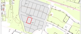
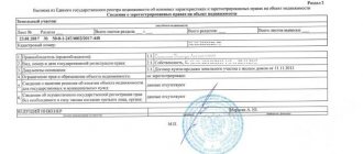
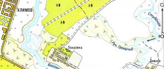
It is a diagram (map), with clearly marked boundaries of the plot , as well as its location relative to neighboring plots or real estate objects. Consists of graphic and text sections.
Contents and sections, what the CP looks like
The cadastral plan (CP) includes the following sections and information :
- Written information about the boundaries of the plot, its size and area;
- Data on the location of the site relative to nearby objects;
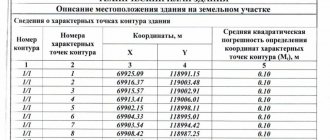
- Cartographic diagram of the allotment indicating clear boundaries, as well as coordinates of nodal and turning points;
- Outlines of real estate objects located on the land plot;
- Site identification number;
- Information confirming land ownership;
- Information about the government agency and their specialist who draws up the plan;
- Text description of neighboring areas;
- Cadastral numbers of neighboring plots;
- Information about the purpose of land: agricultural, residential, development, etc.
It looks like the photo below:
How to find out information through Rosreestr
Every citizen of the Russian Federation has the right to find out the cadastral number of any real estate property. Among other options, this can be done via the Internet by submitting an electronic request to the database on the official Rosreestr web page.
Let's look at step-by-step instructions for performing this operation:
Go to the Rosreestr page on the Internet https://rosreestr.ru/site/.
From the list.
Next, you need to enter the address and click the “Generate request” button.
Thus, the system will provide all the information of interest to the user: the address of the land plot and its cadastral number.
If necessary, from this last received page you can submit a request to the state cadastre to obtain an officially issued document on the property. The statement is provided in paper or electronic form. This service is provided for a fee.
Preparation of documents for submission to Rosreestr
To register with Rosreestr and obtain a cadastral plan, you will need to prepare the following documents :
- Application for registration written by the owner of the land plot;
- Owner's ID;
- Boundary plan of the site;
- Certificate confirming ownership – original and notarized copy;
- The act of agreeing on the boundaries of the land with neighbors;
- Receipt for payment of state duty;
- Certificate of allotment belonging to one or more land use categories;
- If ownership has not yet been formalized, you will need a power of attorney issued by the body for the distribution of state property.
In each individual case, at the discretion of Rosreestr employees, or copies thereof may be required All copies must be certified by a notary.
Cadastral plan of a land plot - what is it?
The cadastral plan (or boundary plan) of a land plot is an official document confirming that it has undergone the land surveying process. It contains complete information about the site, as well as the boundaries and designated objects located on it.
In essence, the cadastral plan is a technical document and is presented in the form of a map on which marks with symbols are applied. In addition to this document, when making transactions with the property, you will need to provide a complete cadastral passport.
The presence of a cadastral plan and passport is also a prerequisite for the ability to build a residential building on a given land plot and register it. And also for other legal actions, including changing the category and purpose of land, registration of encumbrances, litigation surrounding this property.
As a result of registering a plot of land in the cadastral register, the state can control land transactions. Therefore, it is imperative to survey areas and register them with Rosreestr.
In the absence of a cadastral passport, the site, in fact, does not exist either for public utilities or for government bodies. Even if you have property documents, this does not make it possible to receive support from the state in the event of, for example, a natural disaster.
Particularly important is the fact that amendments have been made to the Land Code, according to which, with the onset of 2021, it is prohibited to conduct any transactions with land plots that do not have a cadastral passport. And it is prepared on the basis of the cadastral plan. The plan is a graphic component of the passport and an integral part of it. Without it, it is impossible to register the allotment.
It happens that a plan has been made, but quite a lot of time has passed and a lot has changed on the site, for example, buildings have appeared, the configuration of the plot has changed, or a share has been allocated. Then we should say that the data is outdated and requires correction. In this case, you need to update the plan and, based on it, make changes to the cadastral passport in order to avoid subsequent difficulties before the sale.
Receipt procedure
First you need to carry out land surveying and draw up a land survey plan .
After collecting all the necessary documentation, you can contact the relevant authorities to obtain a cadastral plan.
You can receive it in person or order it online.
You should contact Rosreestr or the MFC (Multifunctional Center), or the Unified State Register of Lands.
To receive a document in person, you should follow the following steps :
- At Rosreestr or at the MFC at your place of residence, take an application form and carefully fill out all the necessary points. Be sure to consult with an employee of the institution on how to fill out the form correctly. Don't forget to indicate the number of copies of the CP you need.
- Provide the registrar with all the necessary documents that you brought with you.
- After checking that the form has been filled out correctly, the registrar must give you a receipt stating that he has accepted your documents and list their names and number of copies.
- Pay the state fee for each copy.
- In a few days (usually 5-7, but sometimes longer, but not more than a month) the documents will be ready. If everything was completed correctly and government employees do not have any complaints or additional questions against you, then you can safely receive them in your hands by presenting a receipt and a passport of a citizen of the Russian Federation.
To receive online via the Internet , do the following:
- On the official website of Rosreestr, go to the “Individuals” tab.
- Click on the tab “Obtaining USRN information”
- Next, go to the tab “Get cadastral plan of territories from the Unified State Register of Real Estate”
- The USRN information request form will open. We fill in all the required fields. In the “In form” column, select what document format you need: a link to an electronic document, a paper document by mail, or a paper format in the territorial department of Rosreestr. We also indicate the public cadastral number and address of your site.
- Go to information about the applicant by clicking in the lower right corner of the form.
- Here we select whether you are an individual or a legal entity, as well as the category of the applicant (you can indicate “Other person”). Fill in all required fields marked with a red exclamation mark. We enter passport data or data from another identification document of the applicant.
- We submit a verification request form, having previously agreed with the transfer of personal data to Rosreestr. After this, you will receive an email with an approximate production time for the CP.
Deadlines
The standard production time for a cadastral plan is 3 working days. This duration is established when applying directly to the Rosreestr branch.
If the request is submitted through the Multifunctional Center, the procedure may take longer. Since MFC employees must send the received documents to the responsible authority, what follows is waiting for the plan to be prepared and sending it back to the MFC for issuance to the applicant.
That is, when issued through the MFC, the issuance period will consist of the standard three working days and the time for transferring documents between structures.
If documents are submitted through government services, then the registration process will also be longer - 3 working days plus the time to transfer documents to the registrar.
How much does it cost and is it necessary to do land surveying?
A prerequisite for drawing up a cadastral plan is land surveying.
Without it, it will not be possible to clearly set boundaries.
An institution called the State Cadastre and third-party cadastral organizations are engaged in this activity.
The survey service on the State Cadastre website at the time of writing costs from 8,000 rubles .
This includes:
- Clarification of the boundaries of the site;
- Division of land;
- Redistribution of allotment.
And a number of other actions indicated on the website in the “Services” section. Depending on the number of services you need, the total cost of land surveying will be determined, starting from 3,500 rubles.
Also, the total cost of the cadastral plan includes the state duty for each copy and the cost of the forms.
Where can I get a cadastral plan?
The cadastral plan can be obtained:
- by personally contacting the Rosreestr authority with a written application;
- through an electronic request form on the website of this government agency;
- by writing a statement at the nearest MFC.
If all the data on this land plot is available in the database, the document will be produced within five calendar days .
The situation is different when there is no information on the allotment in Rosreestr. Then you will need to collect a number of documents and submit them for registration of the site. First you need to indicate the exact coordinates of the site on the ground.
To mark the boundaries of your plot in order to ultimately obtain a cadastral plan, you need to contact cadastral engineers who have the appropriate certificate. Then the finished plan, as part of a number of other required documents, is submitted to Rosreestr for registering a new site or making changes to an existing one.
Features for forest area
According to the current legislation of the Russian Federation, the cadastral registration of forest lands can only be carried out if they are used for recreational activities .
For the uninitiated, this is an activity related to wellness procedures, such as:
- Sanatorium rest;
- Tourism;
- Sports fishing, etc.
Drawing up a cadastral plan directly in this case will not differ much from the actions described above, since legally forest lands are equated to land.
You just need to indicate in the appropriate section the desired category of land use, such as forest lands.
How to read it?
Reading the document is made easier by the fact that it is compiled on several forms, from which you can quickly select the required information. Their designation according to functionality is recorded in the top line of the form.
- The first form indicates the essential cadastral and technical characteristics of the object. Information about the project executor and details of the legal entity are also provided here.
- The following form contains the general configuration of the site indicating the coordinates of the turning points of the memory. It is included in the general array, but separated from it by a special line. Here is information about how boundaries should be positioned, not taking into account the possibility of self-capture, overlapping boundaries and other nuances that require correction.
- In the third section, the previously indicated topographical information is given in text form, in the form of a description of the memory.
- The last two sections are used as necessary if the site has special parts allocated during design or when it is encumbered with an easement.
Each form corresponds to a specific section in which the listed information is classified.