The cadastral number (CN) of a land plot (LP) is a special unique code that does not repeat over time , consisting of several multi-digit numbers separated by a “:” sign and written in the format “XX: XX: XXXXXXXX: XX”.
Each of these numbers is not random and has its own meaning and interpretation.
A cadastral number is assigned when registering a land plot in Rosreestr.
In what documents is it indicated?
If you need your cadastral number, then it will not be superfluous to know in which documents it is indicated.
- Cadastral passport of the land plot;
- Any documents defining ownership of land.
If any legal transactions were carried out in relation to your site , for example:
- Purchase and sale;
- Rent;
- Registration of inheritance;
- Alienation of property, in this case a land plot;
- Donation, etc.
These transactions could not be carried out without registration, which means the cadastral number is already available and is registered in any of the documents drawn up for these transactions.
In some cases it may also be indicated:
- In cadastral terms;
- In terms of boundaries.
Varieties
The cadastral number and its individual parts have their own structure and interpretation. They come in old and new styles, have a certain number of numbers and digital blocks, each of which has its own definition.
Read about all this below.
Old and new
In 2007, further changes were made to the land legislation of Russia, which entailed the introduction of a modern format for the cadastral number and the term itself.
This happened against the backdrop of the reformation and renaming of the country’s main cadastral body into the modern State Real Estate Cadastre - State Real Estate Cadastre.
Before this legislative reform, the cadastral number did not exist in our usual form, and since 1992 it was designated by an accounting code, similar to the modern one, but with several more digital blocks.
If the current code looks in the format “ХХ:ХХ:ХХХХХХХ:ХХ”, then in those days it looked like this: “ХХ:ХХ:ХХХХХХХ:ХХ:Х:Х”, where the last two “:Х:Х” are digital designations of specific buildings on a given site (house, barn, garage, etc.).
Thus, by its appearance, focusing on how many digits are in the code, you can understand whether this is a new cadastral number or an old one.
In the modern version of the cadastral number, buildings on a land plot are not taken into account , since a separate numerical identifier is now provided for them.
Format and transcript
As you saw in the example, the new cadastral numbers consist of four digital blocks , arranged in a strictly defined order. Each of them has its own function to designate.
For example, let’s take a random plot found on a public cadastral map (there is a separate article about it), and decipher its cadastral number - 13:19:0202001:53.
- Block one (13) – the first is always the numerical code of the cadastral district . In our case, this is the code of the Republic of Mordovia.
- Block two (19) – the second is the number of the cadastral district defined for this district. In our case, this is the Temnikovsky district.
- The third numerical block (0202001) means cadastral quarter .
- In the last, fourth block (53) the numeric code of the land plot itself .
The first block of the cadastral number contains 2 digits, the second - the same number. The third block has 7 digits, the fourth block has 2. In total, 13 digits in the entire KN.
Cadastral number: formation, structure and decoding
Below we will talk about how the cadastral number is formed and how it is deciphered, but first we will have to introduce several concepts with which it is directly related. This must be done so that the reader understands what the author means when using this or that concept.
You may like => Privatization Algorithm
That is, the number contains complete information about the location of the site, in which subject of the Federation, in which district, municipality it is located and registered. Combinations of numbers in a number are separated from each other by a colon. In the example you will see what it consists of.
Despite the identical composition of the information, receiving free information about the property identification code will not allow citizens to use it to carry out legally significant actions. Information provided free of charge will make it possible to establish certain facts about the object of interest (its location, area, etc.), including violations committed when registering it with the departments of Rosreestr.
Searching for the specified indicator allows you not only to familiarize yourself with information about the selected object, but also to save the information of interest in various types of files, note comments in the technical description of this type of property in the notes, or send a message about a technical error to the accounting information.
- AA – cadastral district. The territory of Russia is divided into 91 districts, which are assigned two-digit numbers. The first block contains information about the region or area where this site is located.
- ВВ – cadastral region. Their number differs in each district, and they also have two-digit designations.
- SSMMTT – cadastral quarter. These numbers indicate small settlements, city districts, etc. Depending on the area of the district, the block consists of 6 or 7 characters.
- KK – land allotment number. It is assigned by Rosreestr employees when registering an object. Depending on the number of plots located in the territory of the block, it contains one or more numbers.
One can talk for hours about the meaning of such a concept as a number in the cadastre. Certainly, if you are far from this issue, you will not be able to appreciate its full importance. Thus, without such a number it is almost impossible to register ownership of a specific property.
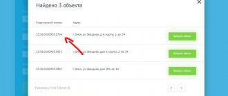
Where can I get a cadastral number for an apartment? You can check this number at the apartment address through the online system. The most convenient way is to search in the Rosreestr database - the Federal Service for State Registration of Cadastre and Cartography.
- View in the cadastral passport. The fastest and easiest way, but the document may contain errors and the code itself may change.
- Through the Rosreestr website. You just need to fill out the form on the page and submit your request. The answer will be sent by email.
Search for land data
What does knowing the cadastral number of a plot give us? Knowing your cadastral number, you can easily locate it on the map, as well as find out a number of basic data on it, which are in the public domain.
How do I locate an allotment on a public map?
To do this, just find a public cadastral map on the Internet and enter the KN of the desired land plot in the search bar .
The map itself will redirect you to the desired area, where its boundaries and nearby neighboring plots will be indicated.
We have written about this in more detail in a separate article.
Purpose
In the descriptions of land plots there is a clause “Land Category”, which indicates the purpose of the plot for which it should be used.
You can find out this on the same public cadastral map, or in the database of cadastral numbers.
This procedure is also described in detail in a separate article.
What is a building cadastral number, what does it mean and what does it consist of?
- legal affiliation (private person, state, municipality);
- information about the current owner and former owners;
- the serial number assigned upon registration of the object;
- current property boundaries and structure;
- existing encumbrances (legal and financial).
The first three indicators are universal and indicate the address of the property - region, district and quarter. Street names and house numbers are data that is not publicly accessible. The last digit is a serial number, which will be individual for each individual object.
May 09, 2021 polrostov 187
Share this post
- Related Posts
- Working Conditions Harmful? Electrician for Repair and Maintenance of Electrical Equipment
- How the Status of a Large Family Tyumen is Confirmed in the Russian Federation
- Alimony on Vacation Without Maintenance
- How long does it take to replace a water meter?
Non-standard situations
From time to time, private, non-standard situations related to the cadastral number occur. We will describe here the most common such legal incidents.
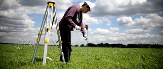
If a land plot does not have a cadastral number, it means that cadastral work related to surveying and establishing precise boundaries was not carried out in a timely manner. Data on such plots are not included in Rosreestr or another cadastral body and the ownership of it seems very doubtful, due to the legal dysfunction of all documents on it.
The absence of this numerical code for the imaginary owner of this property will be reflected in the impossibility of carrying out almost all types of transactions on the site, such as:
- Purchase and sale;
- Land lease;
- Donation agreement;
- Inheritance;
- Inheritance of a land plot under a will.
The absence of a cadastral number will make it difficult for municipal or administrative authorities and any interested third parties to interfere in legal transactions on this land plot.
Without a cadastral number, you can safely cross out all your property claims to this plot, since you do not have ownership rights to it. The only exception may be the situation when, instead of a cadastral number, your plot has a conditional number - their legal significance is almost identical.
Obtaining a land cadastral number and registering it with the State is a priority task for all landowners .
How boundaries change
Changing boundaries is the introduction of additions and adjustments to official documents on a land plot in connection with a decrease or increase in its size. There are the following reasons for changing the boundaries of the quarter:
- Error. In this case, the work is carried out anew, the boundary line is updated and a new cadastral plan is drawn up.
- When the boundaries of towns and cities increase, the merging or division of plots occurs at the initiative of local governments or government agencies.
The procedure for changing the boundaries of a block is labor-intensive and time-consuming. Its registration is completed in the cadastral chamber.
The chamber's work on changing boundaries begins with the submission of an appropriate application.
Assignment to a garden or dacha plot
Garden and summer cottage plots are one of the most common types of land, so the procedure for assigning cadastral numbers to these plots is no different from the standard one .
First, you should prepare a number of necessary documents for the cadastral authorities:
- A document (certificate) confirming ownership of a garden plot. These may be: a purchase and sale agreement, a lease agreement, a gift agreement, a certificate of inheritance, etc.
- If we are talking about the purchase of municipal property into private property, then there must be a corresponding purchase and sale agreement drawn up with the participation of administrative bodies;
- Extract from Rosreestr (USRE/EGRN);
- Boundary plan;
- Technical plan;
- Certificate of citizen of the Russian Federation (passport).
Having all the above documents in hand, you should contact Rosreestr or the Multifunctional Center .
Having paid the state fee and filled out the application form, within a month your garden plot will be assigned a cadastral number and all your rights to it will acquire real legal force.
Change
The need to change the cadastral number arises in cases where there have been any significant changes concerning the land plot.
For example:
- the site has changed its physical address;
- the boundaries of the allotment were changed during land surveying;
- The land plot was merged with other plots;
- the land plot was divided into several smaller plots.
The old number is canceled and is no longer considered valid.
Also, cancellation of the cadastral number of a land plot can be carried out on the initiative of local authorities , if within 5 years after registration with Rosreestr and assignment of the number, the rights to own the land have not been legally formalized.
To change the cadastral number, you should contact the Rosreestr branch at your place of residence, or the multifunctional center (MFC).
The following list of documents
is required :
- Landowner's ID;
- Certificate of ownership of the land plot;
- Land survey and cadastral plan;
- Cadastral passport;
- For buildings erected on the site, a technical plan is needed;
- Extract from the Unified State Register of Real Estate about the property;
- A document confirming the consent of municipal authorities to replace the CN.
Next, at the Rosreestr branch you should fill out an application form, either on the spot or by purchasing a form in advance, which can be downloaded from this link.
There you should indicate :
- The name of the cadastral authority to which the application is submitted;
- The reason why the cadastral number must be changed;
- Information about the applicant;
- List of documents you provide;
- Method of notification of a number change (by mail, in person, or electronically);
- Agree with the processing of personal data;
What is the cadastral number of a property and how is it assigned?
A cadastral number is a number that identifies a property. It is assigned by the rights registration authority when entering information about the object into the Unified State Register and does not change. This number is unique, since it is not repeated over time and on the territory of the Russian Federation (Part 1, Article 5 of the Law on State Registration of Real Estate).
This number is used for cadastral registration of real estate and state registration of rights to it and allows you to identify the property among others. If real estate is removed from cadastral registration, such a number will no longer be used, since it cannot be assigned to another object (clause 6 of the Procedure given in Appendix No. 2 to Order of the Ministry of Economic Development of Russia dated November 24, 2015 N 877). Let us note that the cadastral number must be indicated in all information resources (Part 6, Article 5 of the said Law). A cadastral number is assigned to each property (clause 2 of the Procedure given in Appendix No. 2 to Order of the Ministry of Economic Development of Russia dated November 24, 2015 N 877): · when it is registered for cadastral registration in connection with its formation or creation; · inclusion of information about a previously recorded object. A cadastral number is assigned to a property based on its location. For this purpose, the following division was carried out (clauses 2, 3, 4 of the Procedure given in Appendix No. 1 to Order of the Ministry of Economic Development of Russia dated November 24, 2015 N 877): 1) the territory of the Russian Federation is divided into cadastral districts; 2) cadastral districts - to cadastral districts; 3) cadastral areas - into cadastral blocks. Each division unit is assigned a unique registration number, and districts and districts are also given a name. Each subsequent unit of division includes the accounting number of the previous one (items 3, 4 of the said Order). All these units of division are reflected in the cadastral number of the property. In detail, the procedure for assigning cadastral numbers is given in Appendix No. 2 to Order of the Ministry of Economic Development of Russia dated November 24, 2015 N 877. Note that the cadastral number of a capital construction project does not depend on the cadastral number of the land plot on which it is located. The cadastral number of a property does not change when its characteristics change (Part 1, Article 5 of the Law on State Registration of Real Estate, Clause 7 of the Procedure given in Appendix No. 2 to Order of the Ministry of Economic Development of Russia dated November 24, 2015 No. 877). If the characteristics of an object have changed (for example, the area of a building, in particular as a result of its reconstruction, or the boundaries of a land plot), then changes are made to the information about it contained in the Unified State Register of Real Estate. In this case, only the characteristic of the object that has changed changes (clause 15 of the Procedure for maintaining the Unified State Register). At the same time, we note that if a real estate object is transformed (for example, divided or merged - clause 46 of the Procedure for maintaining the Unified State Register of Real Estate), then a new object (new objects) is formed. When registering for cadastral registration, it will be assigned a cadastral number as a new property (clause 1, clause 2 of the Procedure given in Appendix No. 2 to Order of the Ministry of Economic Development of Russia dated November 24, 2015 N 877). You can find out the cadastral number of a property: 1) from an extract from the Unified State Register of Real Estate. If you yourself applied for registration of a property in the cadastral register or for entering information about a previously registered property (or registered rights to the property), then you were given an extract as confirmation (unless you refused to receive it). It must indicate the cadastral number; 2) using a public cadastral map - by the address of the object or by selecting its location on the map itself. The conditional number is not a cadastral number. It was assigned to real estate objects by the rights registration authority before January 1, 2021 in the event that the object was not assigned a cadastral number (clause 3 of Article 12 of the Law on Registration of Rights to Real Estate N 122-FZ in the previous version). At the same time, we note that land plots were assigned such a number only until January 1, 2005 (clause 2 of the previously in force Instruction, approved by Order of the Ministry of Justice of Russia dated December 8, 2004 N 192). You can distinguish a conventional number from a cadastral number by the sign that separates the parts of the number. In the conditional number this is the sign “-“, and in the cadastral number it is the colon “:”.
You may like => Refinancing Consent
What to do if two numbers are registered for one memory
Sometimes it happens that when viewing your plot on a public cadastral map, two or more cadastral numbers are indicated for the same plot.
In most cases, this is the result of a technical error by Rosreestr employees .
It is recommended to make an extract from the Unified State Register, which should contain more accurate data.
You should also submit an application to correct the cadastral error.
How to do this is described in detail in a separate article.
Assignment when merging two plots into one
There is a legal possibility of combining two or more plots into one, with the simultaneous cancellation of their cadastral numbers and the assignment of a new single CN.
This is possible in cases where the plots are adjacent, with common boundaries.
During this procedure, a number of nuances should be taken into account :
- If there is one owner of all adjacent plots, then he becomes the sole owner of the plot. In most cases, this is exactly what happens. If there are several owners, then you can register joint ownership for them.
- Both or several land plots must be from the same use category. The same category remains with them after the merger.
- If one of the plots is located in another territorial entity, for example, in another cadastral region, then merging these plots is not possible.
- If land plots are used under the rights of temporary free use or perpetual use, then all merged plots must have one owner. In this case, the right of joint ownership is unacceptable.
- All data on the merged plots must be previously entered into the Unified State Register of Real Estate and correspond to reality, and also not have cadastral or technical errors.
The merger procedure itself consists of the following steps :
- After checking all the data and making sure that you do not have any legal contraindications for carrying out this procedure, you should contact Rosreestr, MFC, or other authorities authorized in your territory. Submit an application for the consolidation of land plots and sign the necessary agreement with the administrative authorities.
- Afterwards, an engineer should be sent to you to carry out cadastral work: land surveying, drawing up a cadastral plan, etc.
- After all cadastral work has been completed, the engineer sends all new data to Rosreestr for registration.
- After five days, your land plot will be provided with a new cadastral number, after which you must appear at Rosreestr and register the new plot as your property.
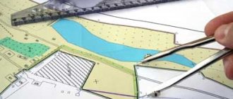
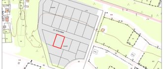
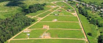
The concept and purpose of the cadastral plan of the territory
Data about each piece of land, as well as its location, are reflected in the general plan of the territory. It is a text document accompanied by an image of a map of the area with designated boundaries and neighboring objects.
In turn, the plan of the cadastral quarter contains aggregate information about the plots included in its composition, as well as their boundaries. This plan consists of text and graphic parts, which include:
- number, area, composition of the block and zones located on its territory;
- brief information about each site;
- a diagram indicating the location of the plan sheets;
- diagram, plans, drawings of sites.
A similar QC plan may be needed when changing the boundaries of plots, as well as when preparing and conducting land surveying. It can be obtained online. To do this you need:
- Go to the Rosreestr website.
- Open the tab “State class=”aligncenter” width=”1337″ height=”524″[/img]
- Select “Get cadastral plan of the territory.”
- Fill out the form and send a request.
- Get documents.
More about why mapping of land plots is necessary.