What is it and why is it needed
If you have the coordinates of the PT, you can establish reliable boundaries, which will be determined with the minimum error permissible when preparing cadastral documentation and carrying out a number of works regarding the sites. In fact, the PT designates with its coordinates the place where the drawn boundary of the section loses the properties of a straight line and bends.
To maintain accuracy and eliminate errors, the boundaries of areas are displayed exclusively using straight lines. At the place where one line stops and, due to the nature of the terrain or the characteristics of the plot itself, the second begins.
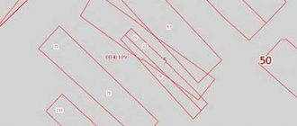
Example PT
By sequentially connecting such points, a closed loop is formed that limits the property limit of the person who has the right to own the site. By applying and taking into account the PT, the following cadastral works and actions related to plots are carried out:
- establishing the boundaries of the land plot ОPrav _ 169-170;
- identification of errors that resulted in the intersection and displacement of the boundaries of ОPrav _ 171;
- removal of site boundaries ОPrav _ 167;
- clarification of the boundaries of the site ОPrav _ 174.
The minimum value for the number of PTs of the section will be four - this way the plot will look perfectly flat with the complete absence of bends and numerous turns.
Such forms are a priority when setting boundaries, but in practice, due to clarifications and the need to place points with reference to the terrain, as well as subsequent adjustments, this ideal form may undergo some changes.
Such changes lead to curvature of the boundaries of the sections and the need to establish the coordinates of additional points, which simultaneously become the end of some straight lines and the beginning of others.
PT designations are entered into the relevant cadastre records and can be in the following forms:
- on electronic media;
- on paper;
- in topographic form.
Layout of PT boundaries of the site
In practice, areas with a significant number of PT are in most cases located in areas where there is a complex topographic pattern and the placement of additional ones (except for the minimum permissible value of 4 units) is necessary.
On the other hand, additional PTs caused by necessity sometimes, on the contrary, lead to the presence of errors in the laid boundaries - if even the slightest error is made regarding just one point of the plot, part of the entire plot can significantly shift to the side.
Such minor inaccuracies sometimes even lead to such incidents that as a result of drawing lines along the coordinates of the PT, one section actually overlaps the adjacent one.
When is turning point restoration required?
The Unified State Register of Real Estate stores data about the land plot, with the help of which the location of turning points is identified, and land survey signs are installed that record the boundaries of the allotment . Let's take a closer look at what it is and why it may be necessary.
Turning points of a land plot are places where surveyors install survey signs necessary to further identify the coordinates of the territory.
According to their location, officially recorded in the technical plan and the State Property Committee, the following is established :
- location of the object or terrain;
- the person who owns the land.
installed signs at characteristic points in the absence of surveying engineers .
There are many situations in which outlining boundaries is necessary:
- Construction of a new building . Survey signs indicate the coordinates of the land plot and help determine the shape and area of the plot in order to prepare for work.
- Acquisition of territory from the previous owner. All transactions related to land carry a certain risk: the data specified in the contract does not correspond to the real parameters of the site. In order to prevent possible disputes with the owners of adjacent territories and problems with purchase and sale, it is necessary to restore the boundaries of the land plot in the area to their previous values, that is, those that were recorded in the register.
- Division of real estate between several owners. Mapping out all points of the allotment will help determine the exact limits and avoid shortcomings when making a transaction.
- Loss of land survey signs . Very often they are rearranged or lost, for which the law provides for a fine of 5 thousand rubles. The procedure for restoring boundaries will help determine the coordinates and shape of the site on the ground.
- Landscape works . When landscaping a land plot, the area and configuration of the plot are of great importance. Having installed land surveying signs, you can begin to design the territory.
The purchased property must be registered. After the data indicating the survey points are reflected in the State Property Committee, the plot will be assigned a cadastral number. After this, the plot of land is an independent unit, and the owner is its legal owner.
The procedure for restoring coordinates on the ground should be approached with all responsibility .
Due to lack of qualifications and experience, specialists make mistakes when determining the boundaries of the plot. As a result, the land survey plan and other documents contain incorrect data.
What it is
PTs belonging to one site must be fixed with special signs, which are called boundary signs. Such points are indicated both directly on the ground and entered into documentation - they are enshrined in an official act signed by a cadastral engineer.
After the coordinates of the points are fixed, their unauthorized transfer in any direction (that is, changing the value reflected in the documentation) is strictly prohibited.
If the owner or user of the site commits such an action without additional approval, this may result in prosecution and the imposition of a serious fine.
After the coordinates are established, a boundary is determined between them, indicating the limits of the person’s property. The result of this action is the drawing up of a special boundary plan, which, as confirmation of accuracy, must have an attached act signed by authorized persons.
Also attached to the boundary plan is a topographic map, which also determines the coordinates of the boundaries with neighboring or adjacent areas. If we take large volumes of land, then the general view of the demarcated areas is presented in the form of a large-scale geodetic network of the Russian Federation, on which you can obtain data about any area that has been allocated from the total mass and find out the specific coordinates of its location.
Act of removal of PT
The coordinates of the borders and PT plots are translated into special codes - each of the selected plots, which has a unique cadastral code value assigned to it, also has its own unique coordinates, data about which is contained in the general database for the Russian Federation - the state real estate cadastre.
In case of discrepancies in the coordinates or the presence of obvious contradictions, the interested person must submit an application to the specialists of this body for clarification or elimination of errors.
What are the coordinates of the memory boundaries?
Turning points are reinforced with special boundary signs, which are transferred to the customer under his responsibility by a special act. Once they are established, arbitrary movement along the area of the boundaries of the landfill or in any other direction is prohibited. For failure to comply with this rule, the violator faces a serious fine.
The fact is that a line is drawn through the designated points , which turns in accordance with the signs established for this. This is a sign of a reliably established boundary line.
After its restoration in kind (on the ground) and the signing of the act, a boundary plan is drawn up. A topographic document is included in the boundary plan, defining the coordinates of the boundary lines or boundaries between adjacent areas.
The boundaries of the land plot are determined by a cadastral engineer who carries out geodetic and topographical work on the site. After the formation of a package of land surveying documents, based on the cadastral plan, the coordinates of the boundaries of the plots are entered into the records of the State Property Committee.
The GKN activity system includes all information about the boundaries of sites and their coordinates as a whole. In the context of regulatory designations, they are defined as a geodetic network of lands of the Russian Federation. And the border coordinates are encrypted into specialized codes, which can be used to find any of the plots and on the basis of which land plots acquire their unique address - cadastral number.
If you encounter discrepancies regarding the boundaries of land plots on the part of various companies or organizations authorized to inventory land, check the data with the State Property Committee.
This organization contains the most reliable information about any of the sites; work on the country’s geodetic network is carried out in the records of the state real estate cadastre systematically, at the highest level, using high-tech equipment and sophisticated calculation methods.
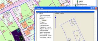
Coordinates of turning points
The coordinates of the control point, which are actually recorded on the site in the form of established boundary signs, are displayed in a special table on the corresponding site plan. It is worth noting one feature - they cannot be included directly in the cadastral plan - if it is necessary to use such points, you will need to request an extract from the Unified Land Management.
Such an extract is presented in the KV6 form; on the first page of this form the coordinates of the points of interest on the site will be written out. Each of these points is indicated by two coordinates - one of them is displayed along the X-axis, the second along the Y-axis.
Form KV6 from the cadastral extract
It is worth noting that even the available information about what coordinates the PT has, for people who are not specialists in this matter, will not provide much assistance in independently checking or establishing boundaries - such data can only be used by a qualified cadastral engineer.
When determining coordinates, the following actions are performed:
- The position of the contour points is determined directly at the site of their installation. Moreover, each place in which the line ceases to be straight and breaks must be indicated by placing such a point;
- places are marked directly on the ground - often temporary pegs are simply placed on the site;
PT construction process - replacing temporarily installed pegs with permanent signs that meet established standards and requirements;
- entering marks into accounting documentation;
- carrying out special calculations that make it possible to establish the location of the intersection lines by coordinates at each of the intersection points;
- establishment.
When determining, several existing methods are used:
- geodesic;
- satellite measurement method;
- photogrammetric method;
- cartometry method;
- analytical.
When transferring the obtained coordinates into topographic documents, they are described in a coordinate system that is used exclusively for designations in the cadastre.
What are the coordinates of turning points and how to determine them?
Any plot of land has boundaries, and its configuration is fixed by a specialized line on the cadastral plan.
If the territory in certain places has bends and turns or its perimeter changes direction at an angle, forms a roundness, the change in direct movement on these sections of the border is fixed by boundary markers or topographic signs on the cadastral plan (map), which are the coordinates of turning points on the ground. These markers in the form of boundary signs installed at turning points are prohibited from being removed or changed in their location.
Thus, the coordinates of turning points are entered with a detailed description into a special table located in the information bank of the State Real Estate Cadastre.
To enter, a standard registration card is used, with the help of which the boundaries of a certain territory must be entered into the electronic database of the land cadastre, and the data is also recorded in the catalog of coordinates of boundary signs and restrictions. Using the information stored in these documents, it will not be difficult to identify errors and violations of the boundaries of the site by the owner or his neighbors.
Rosreestr is responsible for information recorded by these methods, and the legality of entry, correctness of description and rules for storing data are regulated by Federal Law No. 221.
About keypoints
A characteristic point of the boundary of a land plot is a designation that helps determine the boundary line of a separate territory; it is at these points that boundary signs are installed.
The location of characteristic points is recorded in the survey file, which is transferred by the cadastral engineer to the State Real Estate Cadastre (GKN).
This helps to highlight the location of the site on the ground, separating it from the rest of the areas surrounding it, and also to record the person or persons who own the territory or parts of it.
Nodal outlines
The section “Outlines of land plot boundary points” is included in the boundary plan in the case when the plots have contact coordinates that are common to three or more plots (nodal points) and within a radius of 40 m from the nodal point there are three or more terrain elements (power line supports , buildings, structures and their elements).
Determining coordinates
The presence of turning points on the plan allows you to reliably fix the boundaries. In those places where the boundary of the territory bends, losing the shape of a straight line, and where the lines turn, characteristic points are placed.
Turning points
The cadastral engineer, having completed an application to remove the boundaries of the land plot in kind, begins to prepare the technical specifications, which, in the future, will be used by surveyors to work on the ground.
To compile it you need:
- obtain an extract from Rosreestr;
- study the map (plan) of the storage facility;
- find out where the turning points are located in the surrounding areas;
- determine where these marks will be located on the perimeter.
At the next stage, surveyors, working on the ground, carry out the following actions:
- carrying out topographic measurements;
- checking the correctness of the land plot plan;
- fixing the locations of the planned turning points (arrangement of pegs).
Next, the cadastral engineer checks the work performed and also receives a report with measurements from surveyors. Having checked the correct location of the turning points, he draws the boundaries of the land plot.
Determining boundaries by coordinates
After the boundaries of the site are determined on the plan, they are taken out into the area, while separating the land area from the space that is no longer part of it. Cadastral work is carried out both on the ground and on the land plan.
Guided by the technical specifications, which contain all the data on the boundaries of the site, preliminary markings are carried out, after which the land survey lines are determined.
Sequence of cadastral works on the ground:
- At the turning points noted in the technical specifications, either permanent signs with plates or temporary signs (pegs) are placed;
- Lines are drawn between the pegs, building the contour of the boundary line;
- The surveyor ensures that the line between the pegs remains level, because if the line is drawn incorrectly, it may be displaced on the ground.
After all of the above actions, the boundary boundaries of the site indicated on the diagram are checked with the territory line on the ground. An electronic report is sent to Rosreestr, and the customer receives a boundary plan on paper. The type of boundary plan depends on the purpose of the survey.
Defining boundaries
Determination of limits by coordinates is carried out by obtaining these documents used to confirm ownership of a specific plot. It is worth noting that any action as a result of which the land surveying procedure is carried out allows for further corrective actions and clarification of data for each site.
The procedure for drawing the boundaries of an allotment is necessarily preceded by cadastral work carried out by engineers, on the basis of which the coordinates are determined, which become the basis for the boundaries of the future isolated plot.
Extract from the Unified State Register of Real Estate about the site
Based on the document data, the owner of the plot or his authorized person orders an extract from the cadastre containing all existing changes.
Next, directly at the location of the site, the specified data is verified and the possibility of placing the points in this way is determined. If necessary, taking into account the characteristics of the territory, adjustments are made, in connection with which new PTs are installed, for which cadastral registration data will be entered.
When surveying coordinates, the following types of actions can be performed:
- their original definition;
- clarification of the coordinates of subsequently identified inaccuracies or special requests from land owners;
Cadastral extract describing the location of the boundaries of the land plot - change. Such an action can be carried out in connection with changes to the configuration, adding additional area, etc.;
- recovery when, as a result of actions or work performed, data may be inaccurate or completely lost;
- elimination of disputes between owners of adjacent territories when clarification or adjustment is carried out.
Accuracy and error
When establishing points, the concept of data accuracy and the existing error in it is actively used. In practice, depending on the category of the site, a certain error in the data provided is allowed; if this is exceeded, additional actions must be taken to clarify it.
For what reason does the category of land ownership or its purpose have different acceptable error values? This fact is due to the fact that if certain lands are not allocated to private ownership and are quite large in size, for example, a wide forest area, then greater accuracy does not matter.
Errors and inaccuracies during surveying
On the other hand, plots for construction, summer cottages, and gardening require high levels of accuracy, since sometimes even a few centimeters become the subject of a dispute between the owners of adjacent plots and the cause of litigation.
Land legislation defines the following values of permissible errors in relation to various types and types of land plots:
- areas located within populated areas - no more than 10 centimeters;
- lands whose purpose is agriculture, construction of garages, summer cottages, personal farming, etc. – no more than 20 centimeters;
- lands used for growing agricultural crops and cultivation (without the construction of residential buildings) - up to 250 centimeters;
- lands that are intended to accommodate various enterprises and energy facilities - up to 0.5 meters;
- areas belonging to the water fund, forest - up to 5 meters.
Such standards must be observed, and the presence of errors exceeding acceptable values entails a clarification procedure. The maximum accuracy of the measurements taken is currently achieved thanks to the availability of equipment that takes photographs with a high level of accuracy and the ability to enlarge images. As a result of obtaining such reliable images, coordinates can be transferred to real areas (in situ).
Outlines of nodal points of land boundaries
Separately, when creating a boundary plan of a land plot, such a concept as an outline is used. Under its definition lies a list of data on the location of these points on the site, which can be changed or clarified directly on the ground and such an action may be associated with their binding to certain solid elements.
Such data is presented as a separate part (section) of the boundary plan and must be reflected in the following situations:
- in the event that during the formation of one or several plots through their division, allocation, redistribution, a new point is formed that is related to a large number of adjacent plots (at least three);
Example of outlines - in situations where, through the implementation of cadastral work related to the clarification of data on the position of the border, in parallel with such an action, data on the location of a point on coordinates that is common to at least three separately located but adjacent areas is clarified.
There is one peculiarity regarding outlines - they are compiled exclusively for points that are new and must contain at least three terrain objects within a radius of up to 40 meters.
Such objects must be durable in nature and clearly and easily identifiable. For example, these may include construction sites, buildings and permanently installed structures of a non-temporary nature, supports of power lines passing close to areas.
Also, when installing outlines, the following features should be taken into account:
- the outlines indicate the distance values from the most established point to the objects to which they are attached;
- each nodal point is subject to entering data about its coordinates separately;
- on one drawing sheet it is allowed to place outlines relative to several nodal points.