Algorithm of actions in 2021
When a situation arises when cadastral inspection specialists discover erroneous data, according to the regulations, they are obliged to stop all work on a given plot until the inaccuracies are corrected.
In addition, the incorrectness of the data can be determined by the owner or cadastral engineer. Then you need to declare an error in the boundary space and demand that the violations be corrected.
According to the regulations, technical errors are subject to correction based on their detection by cadastral authorities.
Persons holding senior positions in the specified body can initiate the correction of such data. Management receives information regarding errors in the prescribed form.
In the event that an application is received containing a request to correct errors regarding the imposition of limits, the cadastral authority has the authority to make a decision to refuse to consider such an issue. This applies to situations where the errors are not obvious.
The competence of the cadastral service does not include solving the problems under consideration, but without its participation the records cannot be corrected. In accordance with the state of affairs that may exist today, rules have been developed that make it possible to preserve the rights of all persons who have an interest in this issue. In addition, legal norms for resolving this issue are observed.
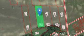
An example of overlaying the boundaries of settlements and land plots
In the event that a person has discovered the fact that restrictions have been imposed on the plot belonging to him, he should contact:
- with a statement containing a request to correct erroneous data on the imposition of boundaries to the cadastre department, which sets out in detail the existing violations;
- You can contact a neighbor who has violated the boundaries.
The listed actions can help lead to the desired result in a situation where the following actions will be taken by persons who have been warned about the detection of violations:
- employees of the cadastral authority make a decision on the need to correct the detected deficiencies and restore the proper location of boundary boundaries and corresponding signs;
- persons who have rights to the neighboring plot will agree with the applicant’s arguments and propose to carry out a joint land surveying procedure with the further restoration of previously established boundaries and boundary signs.
Causes
In a situation where there is a fact of imposing limits, there are obvious errors. At the state level, it is allowed to enter erroneous data into the register based on the results of accounting and geodetic work, the condition being that they will be corrected after they are discovered. Errors introduced into accounts can be classified as:
- technical - such errors are introduced due to typos, clerical errors, or through unintentional substitutions of symbols during codification;
- cadastral – allowed when cadastral boundaries are established incorrectly (this is done when carrying out topographical or cadastral activities).
In any of the presented cases, errors can lead the geodetic network away from the direction that is considered appropriate. This occurs through a digital glitch in encryption, or as a result of erroneous calculations made on site or during the preparation of plans.
The need to file a claim
It should be noted that the above actions will need to be carried out in any case, even when the owner is confident that people living in the neighborhood will refuse to resolve the issue peacefully.
These actions are a mandatory step towards considering the case in court, provided that the person was unable to restore justice in any other way. Before going to court, it is mandatory to make two appeals: to neighbors and to the cadastral authority.
In a situation where a submitted appeal, which is drawn up properly, is ignored by these two parties, a person has the right to appeal to the court. The fact of pre-trial treatment must be documented. If the owner ignores the appeal to any of the parties, his claim will not be accepted for consideration by the judge.
About solutions
The simplest situation will be for landowners whose problem will be discovered at the stage of preparing cadastral documentation. At this stage, the registering authority can independently detect the inaccuracy and eliminate it, having sufficient competence to do so. Rosreestr has an obligation to respond to information about errors provided by copyright holders or their authorized representatives. As soon as minimal doubts arise about the correctness of the position of land ownership boundaries, they resort to removing the boundaries of the land plot. If such doubts do not arise, but boundary measures have not been completed, it is extremely important to organize them in the shortest possible time. If any violations are discovered during the removal of boundaries, a qualified cadastral engineer is involved in the work. He generates a report based on the results of the geodetic survey he organized. It is difficult to overestimate the role of a specialist in this matter.
As soon as an actual overlap of the boundaries of the land plot is discovered, you must immediately go to one of the MFC representative offices to submit an application to the management of the State Cadastre. The form will contain a request to organize a verification of information regarding a specific land ownership. The official is obliged to assign the appropriate status to the application within five days. There are only two acceptable statuses for such cases - rejected and referred for review. If the application is accepted for consideration, a response may be provided within a calendar month. It is important that during the period of execution of the application no legal proceedings are initiated against the object. Representatives of Rosreestr are authorized to correct situations reflected in the Law on the State Property Committee No. 221-FZ of 2007. In other cases, going to court cannot be avoided.
Documentation
It is necessary to engage in the process of collecting the necessary papers until the claim is filed. A photocopy is made of all documentation, which is attached to the claim and listed in the application as an attachment. It is imperative to provide documentation confirming that the person has ownership rights in relation to the allotment. Cadastral documentation is also subject to collection.
Cadastral passport of the land plot
The plaintiff must ensure that there is evidence that he has followed the conciliatory boundary setting procedure. You need to prove it by contacting the persons whose plots are located in the neighborhood, as well as the cadastral authority. Also subject to collection are various certificates and acts that can confirm the validity of the stated claim.
Evidence expressed in writing and capable of reflecting the reason for filing a claim is used as evidence.
It is required to collect all the papers that are relevant to the case under consideration. Efforts also need to be made to find witnesses who can confirm the truth of the plaintiff’s words in a judicial body.
The conclusion issued by the cadastral engineer is considered as important evidence. An extract from the cadastre is also provided indicating what boundaries are established.
How to write?
According to the legal rules, the claim must be filed in the district court where the plot is located. When drawing up a document, it is required to indicate information about the plaintiff and the defendant, and who the owner of the neighboring plot is. When the imposition may be in relation to several plots, all persons are defendants:
- with whose allotments the overlap takes place;
- those who received a warning;
- those who refused to cooperate in a peaceful manner;
- persons who spoke negatively about the restoration of order regarding the restoration of borders.
In the event that there are more than two parties to the conflict, there may be various scenarios for the development of events during the trial, including someone who may support the point of view of the plaintiff, and the municipal administration may be recognized as one of the defendants. In this case, you need to proceed from the state of affairs that takes place.
Sample claim for establishing memory limits
When there are neighbors who support the applicant’s point of view, they can also be recognized as plaintiffs and indicated in this status in the claim. If the removal of the boundaries of a land plot (ОPrav _ 167) or another imposition situation occurred due to the fault of the administration, then the head of the municipality is listed as a defendant in the application.
The document also reflects the characteristics of the allotment and specifies the reasons why such an overlay was determined. The claims must contain: demands from neighbors regarding land surveying and restoration of boundaries. You also need to demand that the entries made in the cadastre be corrected.
During the process of cadastral survey work, a cadastral engineer may identify the intersection of the boundaries of a land plot with the boundaries of adjacent plots, information about which was previously entered into the Unified State Register of Real Estate, which can lead to disagreements between the owners (possessors) of adjacent plots.
If, as a result of cadastral work, the location of the boundaries of your land plot or the boundaries of adjacent land plots, information about which is included in the Unified State Register, is clarified, the location of the boundaries of land plots is subject to mandatory agreement between you and other persons who own adjacent plots of land by right of ownership or other property right ( regardless of the presence in the Unified State Register of Information about registered rights to the specified land plots or information about the coordinates of characteristic points of their boundaries or other description of the location of the boundaries). The subject of agreement is to determine the location of the boundary of the land plot, which is also the boundary of the neighboring land plot. If the reason for crossing the boundaries of land plots is a technical or registry error in the USRN information about a land plot, the cadastral registration of which was carried out earlier, it can be corrected in accordance with Art. 61 of the Law on State Registration. If you cannot resolve the issue of crossing the boundaries of a land plot through negotiations with neighbors, you will have to go to court. As the defendant in the case, it is necessary to indicate the owner of the adjacent land plot, and as third parties - the rights registration authority and the cadastral engineer who carried out the land survey. It is also necessary to correctly formulate the requirements for the court (Part 2 of Article 131 of the Code of Civil Procedure of the Russian Federation). The claims, depending on the circumstances of the case, may be as follows: - recognize the location of the adjacent border of the defendant’s land plot as a technical or registry error; — establish an adjacent border between land plots (as a rule, in accordance with the coordinates indicated in the conclusion of the cadastral engineer). The following must be attached to the statement of claim: - copies of the statement of claim according to the number of persons participating in the case; — copies of title and title documents for the land plot (certificate of state registration of rights, extract from the Unified State Register of Real Estate); — a copy of the boundary plan prepared by the cadastral engineer; — an extract from the Unified State Register of Real Estate about the neighboring land plot; — receipt for payment of state duty; - other documents, as well as copies of documents confirming your claims, according to the number of defendants and third parties. The claim is brought at the location of the land plot. When considering cases on establishing the boundaries of a land plot, the court may order a land management examination to establish compliance with the norms of the current legislation of the cadastral work carried out, as well as to determine the coordinates of the location of the adjacent border between the plots of the plaintiff and the defendant. After the court decision comes into force, you need to contact the rights registration authority to register the land plot in the cadastral register or to clarify the boundaries. The rights registration authority is obliged to correct the error and carry out cadastral registration.
Case review procedure in 2021
The process of considering the case is carried out in the order of holding debates between the parties. In this case, the plaintiff must, concisely, clearly and as non-emotionally as possible, convey to the court the essence of the situation that has arisen and justify the claim brought against the defendant. After this, the floor is given to the defendant so that he has the opportunity to express his opponent’s position.
Plaintiffs are advised to base their argument on facts that have been confirmed. After it is announced that the defendant committed a violation, the plaintiff must submit to the court a document confirming this. The transfer takes place through a bailiff.
The most important thing in a court hearing is to prove that a violation of rights took place. It is worth keeping in mind that it is precisely this moment that is considered to be the cause of legal disputes that arise. The judge must make a conclusion about whether the plaintiff’s claims are legal and have sufficient justification.
Making a decision
After the problem stated in the statement of claim is considered by the court, a reasoned decision is made. To do this, the judicial panel must obtain a clear picture of what happened. If the situation develops unambiguously, then the period allotted for making a decision will be no more than 2 months. The countdown begins from the date on which the claim was filed in court.
When judges have doubts about the facts stated in a claim, they have the power to adjourn or dismiss the claims. In such a situation, the period for consideration of the claim will be delayed.
If the court makes a decision that does not satisfy the plaintiff, he has the opportunity to appeal it within 10 days. The period begins to run when a copy of the court decision has been received.
When the court makes a decision to satisfy the demands made by the plaintiff, the latter has the opportunity, on the basis of this act, to restore the previously existing boundaries. This is done by carrying out boundary work and eliminating erroneous data from the register.
How to challenge the crossing of land boundaries
If the rights of a land owner are violated, he can solve the problem without going to court, taking into account legislative norms and amendments to the Land Code that facilitate the interaction of landowners with government agencies. Otherwise, you should file a claim in court.
Without going to court
According to legislative acts, if it is necessary to correct a cadastral error in the event of erroneous information on a land plot recorded in the past, the registering authority must make a decision regarding the suspension of cadastral registration for a time.
To promptly eliminate the intersection, it is possible to draw up a boundary plan with information regarding the allotment being specified/created, and the location of the border of the land plot.
The boundary plan is accompanied by an act of approval of the location of the boundaries of land plots whose location contains errors. Experts say that if, when they are eliminated, the configuration or area within the boundaries of the registered area does not change, then the approval act will not be issued.
Through the court
Most often, it is not possible to peacefully resolve the problem when crossing the boundaries of a land plot, since land disputes have been waged by people for a long time, sometimes degenerating into hostility between several generations of neighboring families.
Coordination of the location of plot boundaries in court in most cases is associated with the neighbor’s disagreement with the specified outlines. Land disputes of this kind in court most often drag on for a long time, so it is worth being patient.
In order to challenge the location of the boundary of a land plot in court, you should carefully draw up a claim, indicating in it all the data related to the case.
After the court makes a decision in favor of the plaintiff, you need to contact the local cadastral registration authorities, which decided to suspend cadastral registration to eliminate the intersection problem. Cadastre specialists take into account whether the court decision for the site contains a boundary plan where the exact coordinates are indicated.
Therefore, for the further successful work of employees, it is important that the boundaries of two adjacent plots are included in the documentation, which will affect the rapid introduction of changes. Lawyers believe that when drawing up a claim, it is important to require that the correct geodetic data, position and coordinates of the plots be included in the court decision.
Corrected information undergoes state registration based on an application. It must be submitted to the State Real Estate Cadastre (GKN).
If the boundaries of the site cross the boundaries of the village
Modern legislation states that if a crossing of the boundaries of land plots is detected, cadastral work should be suspended until this situation is corrected.
Situations often arise when the border intersects with a neighboring one. In this case, this may be the border of a populated area. In order to solve the problem, you will need to eliminate the intersection. The first thing you need to do is find out why such an intersection arose.
The problem in this case is subject to a simple solution - the cadastral authorities must make the necessary changes to the existing state of affairs. To obtain such a result, they will not have to spend either time or money. It is worth noting that the owner of the site may not take part in the process under consideration.
If a mistake is made by a cadastral engineer during work on the land, it can be eliminated out of court or in court. It is worth noting that the issue of clarifying the boundaries is resolved through a court hearing.
When the rights of a landowner are violated, he has the opportunity to solve the problem by using existing rules of law without resorting to judicial authorities. When municipal authorities do not want to resolve the issue peacefully, they go to court.
Why does the crossing of plot boundaries occur?
It happens that the border of a land plot intersects the neighboring one. The solution to the problem is to eliminate the intersection. First you need to find out with maximum accuracy the causes of this phenomenon.
It happens that the cadastral engineer made a mistake, for example, the information in the cadastral passport and the real estate register about the boundaries does not match or is noticeably different from each other.
The problem is solved quite simply: the organization of territorial registration by cadastral authorities must itself make important changes. Obtaining results does not require time or financial costs. In addition, the owner of the plot may not participate in the process.
Things will be different if an error was made by a cadastral land surveyor while working on the site.
Federal Law Art. No. 28 part 4. says that in this case the error is resolved as follows:
- in the form of information, when documentation with erroneous information included in the state register is similar to papers that were sent to cadastral registration for interaction in the information field;
- if the papers with an error refer to documents specified in Federal Law Article 22 on the cadastre;
- on the basis of a court decision received by the plaintiff immediately after the court hearing on the case.
In the first two situations, the error that caused the intersection is eliminated out of court. Then the clarification of boundaries occurs exclusively through the court.
In the presented video, the author talks about typical situations for correcting errors when one border crosses another territory.
And here is the second part of the video, which examines the intersection of two or more sections: