Pravozhil.com > Real estate registration > Land registration > How to change the boundaries of a land plot - basic rules and nuances
Any land plots have such individual characteristics as area, configuration, exact coordinates and boundaries.
However, for various reasons, the actual and previously established boundaries may not coincide. In this case, the question arises about their clarification. We'll talk about how to change the boundaries of a land plot below.
How to change the boundaries of a land plot?
Is it possible to change the boundaries of a land plot registered in the cadastral register?
Owners of individual plots of land quite often use their plots within the established boundaries.
Not many of them think of checking land documents and verifying data. However, sometimes they have to face such a problem.
For example, neighbors begin to argue, claiming that they have taken part of their land. Or, in the land documents, a discrepancy between the actual data and the information contained in the unified cadastre was discovered.
Or the owner wants to officially annex part of the used land to his plot. In all these cases, it will be necessary to clarify the boundaries of the existing site.
Based on the results of the clarifications made, they may change towards decrease or increase. In addition, the boundaries may move, but the area of the land plot may remain the same.
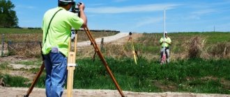
In any case, the owners cannot independently change the parameters of the plots they own. To do this, it is necessary to attract a specialist who will carry out a range of relevant work.
Basic Concepts
Changing the boundaries of a land plot is a set of measures aimed at clarifying the size of the territory and, if necessary, making changes to the current documentation. This is documented only if the territorial zone actually shifts in one direction or another.
Simply entering updated data is not enough; it is necessary for the government agency to record the declared changes. To do this, the document with adjustments is submitted to the state body - Rosreestr, which directly records the changes made and approves the declared data with a seal.
A document with measured boundaries is submitted to the branch of Rosreestr at the location of the limited territory.
Important! Despite the fact that Russian legislation provides permission to reduce and increase the boundaries of the allotment, it must be taken into account that if the margin of error is allowed to be exaggerated, then the entered information must be correctly documented.
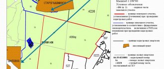
When changing the boundaries of a land plot, all data must be entered immediately onto a paper plan Source ndv.ru
Changing the boundaries of a land plot without changing the area
Site configuration - what is it?
Changing the existing boundaries of plots does not always lead to a change in their area. Situations are possible when, as a result of clarifying measurements, a shift in the boundaries of the existing site occurs.
In fact, the site itself remains unchanged in size and even configuration, but its location partly changes. This is not reflected in the area of the land plot.
However, it requires making appropriate changes to the technical and legal documents about the site. At the same time, most often the boundaries of the plots change upward.
The procedure for resolving disputes when agreeing on the location of site boundaries
The law of the Russian Federation provides for a procedure for pre-trial dispute resolution, during which all disputes between owners of neighboring land plots must be resolved through re-approval.
The owner of the site must:
- Go to the quarterly - the person who decides the issues of your street area.
- Contact your neighbor with him and try to negotiate peacefully where new boundaries should be established and for what reasons they were violated.
- Obtain personal written consent from the owner of the neighboring territory.
- If the owner is against it, then ask the police officer to write a document in which he confirms the appeal to the neighbor.
If for some reason the dispute could not be agreed upon, then the case should be considered in court.
Changing the boundaries of a privatized plot without the consent of the owners
As a general rule, in order to make changes to the boundaries of a plot, it is necessary to obtain the consent of neighboring plot owners.
More precisely, it is necessary that the owners of neighboring plots not express objections to this matter. When surveying, it is usually necessary to coordinate the established boundaries with the owners of adjacent plots.
Otherwise, disputes about the boundaries of adjacent lands will have to be resolved in court. And this is a rather unpleasant and lengthy procedure.
Legal basis and documentation for establishing boundaries of land plots
The settlement of relations that arise during the procedure of land surveying and establishing boundaries, as well as the formation of property in the state cadastral register, is accompanied by Federal Law number 221
, approved on July 24, 2007. This is the main document that regulates and controls this procedure and the work of specialists.
There is also an order from the Russian Ministry of Economic Development
, adopted on November 24, 2008, under number 412. It contains the requirements and rules for preparing a land survey plan, and also states the placement of markers on the boundaries of land plots.
Consequences of the procedure for changing the boundaries of the site
What should the owner of a land plot know?
As a result of clarifying the boundaries of the plots, certain changes occur in the characteristics of the real estate object itself, i.e. the plot.
Therefore, in order for the owner to be able to freely use and dispose of his land within established limits, these changes must be officially registered.
After registration, these changes will be binding for everyone. Their validity can only be challenged in court.
What it is?
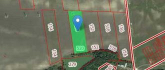
Clarifying the location of the boundaries of a land plot is a type of cadastral work intended to determine, in accordance with which the following is established:
- location of the memory in the surrounding context;
- its exact area;
- configuration.
Also, clarifying the boundaries of a land plot is an important and necessary procedure for the owner of the plot. During the procedure, it is allowed, in accordance with the norms of Federal Law No. 171-FZ, dated June 23, 2014.
Primarily arises as a consequence of disputes between owners of adjacent plots
. Sometimes it is identified by the registration authority as a result of registering a property transaction.
As a result of clarifying the boundaries, an increase in the storage area is allowed
, based on legal precedents.
It may also be reduced
if the territory of the allotment is arbitrarily and unlawfully expanded.
What does it mean to change the boundaries of a land plot without changing the area?
Changing the boundaries of a land plot without changing the area means drawing boundary lines along refined coordinates, which can be associated with a more accurate determination of the location of turning points.
In this case, changing the configuration is allowed, while generally maintaining the area. Or the location of the plot partially changes if one of the owners of adjacent plots has expanded its boundaries, and the adjacent lands have moved, maintaining the areas established for legal use. Refers to the legal and cadastral procedure for the restoration of borders
.
Such precedents predominantly arise when
. They are connected with the fact that due to an accidental or deliberately dishonest action of one of the owners, a precedent of squatting occurred on the basis of a violation of Art. 7.1 Code of Administrative Offenses of the Russian Federation.
Code of Administrative Offenses of the Russian Federation, Article 7.1. Unauthorized occupation of land
Unauthorized occupation of a land plot or part of a land plot, including the use of a land plot by a person who does not have the rights to the specified land plot provided for by the legislation of the Russian Federation -
entails the imposition of an administrative fine, if the cadastral value of the land plot is determined, on citizens in the amount of 1 to 1.5 percent of the cadastral value of the land plot, but not less than five thousand rubles; for officials - from 1.5 to 2 percent of the cadastral value of the land plot, but not less than twenty thousand rubles; for legal entities - from 2 to 3 percent of the cadastral value of the land plot, but not less than one hundred thousand rubles, and if the cadastral value of the land plot has not been determined, for citizens in the amount of five thousand to ten thousand rubles; for officials - from twenty thousand to fifty thousand rubles; for legal entities - from one hundred thousand to two hundred thousand rubles.
Notes:
- For administrative offenses provided for in this article, persons carrying out entrepreneurial activities without forming a legal entity bear administrative liability as legal entities.
- In the case of unauthorized occupation of a part of a land plot, an administrative fine, calculated from the cadastral value of the land plot, is calculated in proportion to the area of the unauthorized occupied part of the land plot.
Counting his legal area from erroneously established boundary lines, the owner shifts his plot. Or - it expands it at the expense of municipal lands - for example, giving it a rectangular shape instead of a square one.
Illegal use of space that does not belong to the owner leads to a violation of the registration procedure and property rights of neighbors (the municipality). Involves administrative liability and penalties (described in more detail about liability).
The procedure for changing the configuration of a land plot through the court
Changing existing property boundaries often causes a lot of controversy. If the owners of neighboring plots object to the changes, the dispute will have to be resolved in court. To do this, you need to file a corresponding statement of claim in court.
The claim must indicate the name and details of the parties to the dispute, all the circumstances of the case, information about the site, and the rationale for changing the boundaries. Such disputes are not easy, so when drawing up a claim and defending your position in the process, it is better to use the help of a lawyer.
Based on the results of consideration of the claim, the court may decide to change the configuration of the existing site. And this decision will already be the basis for making appropriate changes to the land documents.
Cost of land and proximity to facilities
There are man-made and natural objects, the proximity of the land to which can influence both the cost of acquisition and the mood of the owners. Let's look at some of them:
- Forest. It is usually regarded positively - berries and mushrooms grow there in the warm season, which helps to relax and even feed yourself.
- Railway. The tracks themselves usually only reduce the cost of land, because noise and vibration often disturb sleep, and trains do not stop in the middle of a forest or field.
- Water. A river or lake is one of the factors that increases the price of the surrounding areas: here you can fish, sunbathe on the beach, and walk.
- Social infrastructure. A kindergarten, a school, a place of work, medical institutions, shopping facilities - the more points mentioned above are nearby, the more expensive the land plot is valued.
Finally
The boundaries of existing land plots may change. However, to officially establish new boundaries, a certain procedure must be followed.
At the same time, you need to be prepared for the fact that the owners of neighboring plots will express their objections to this matter.
You can learn about the practice of resolving disputes about establishing the boundaries of a land plot by watching the video:
See also Phone numbers for consultation Nov 26, 2021 kasjanenko 1197
Share this post
Discussion: 2 comments
- Faina says:
04/22/2019 at 05:14please let me know where there are standard agreement forms
Answer
- 5master5 says:
04/28/2019 at 11:55
I think that while the dacha amnesty period has been extended, we should definitely take advantage of securing the boundaries of our plot. That is, formalize land surveying and settle all ambiguities with neighbors. In the future, if you delay this matter, you shouldn’t expect anything good.
Answer
Site relief assessment
The ideal option is when the purchased hectares are characterized by maximum flatness, without height differences. In practice, this is rare, although there may be some positive factors, such as the proximity of a river. They make the presence of slopes inevitable. In addition, the unusual configuration of the area will provide the opportunity to implement complex design developments.
You should think about where the water flows - it’s not critical if there is a slight bias in one direction, but if the beam is located at the bottom, water from all the surrounding areas will flow here and flood the area. The same applies to the presence of a hole in the center of the plot.
Configuration features also affect the cost of construction - depending on the conditions, you will have to pay attention to different types of foundation. Here are the general patterns of foundation types:
- Tape. Relatively inexpensive, suitable only for areas with a low probability of flooding.
- Pile. It is more expensive, quite difficult to implement, and will not withstand buildings, but it allows you to build even in a swamp and reliably protects against rising water levels.
- Slab. The most expensive option, but at the same time very stable and can withstand tens of tons.
Search: in person or with an intermediary?
An independent search usually costs significantly less, but only competent intermediaries can suggest the best solution - for example, like our company. The main field of our activity is the development of cottage settlements from scratch: we create cottage settlements with plots with all the amenities and communications necessary for a modern person, we develop infrastructure, and build our own roads.
What documents should I pay attention to?
It is important to check whether the purchase and sale transaction is carried out legally and legally.
Documents for the land plot:
- the seller’s right to the property (registration certificate, basis for registration, cadastral passport);
- documents confirming the legal possibility of sale (absence of arrest; absence of structures that are sold separately; consent of the spouse and certificate of legal capacity of the seller).
- certificate of standard value.
Documents for a plot for cottage construction
A plot of land for cottage construction is sold with all the above documents, also required:
- technical conditions for connecting communications;
- town planning permission for development;
- project documentation.
Although the owner himself can theoretically carry out the development, he must be sure that he will succeed. In some situations, his potential home will be left without water or electricity, in others he will not be allowed to build there at all. For this reason, it is recommended to go through all formalities only with the support of a real estate notary.
Solving the problem of crossing plot boundaries without going to court
Actions to eliminate identified cadastral errors without the participation of judicial authorities are regulated by the recommendation letter of the Ministry of Economic Development No. 4448-IM\D23, signed on March 27, 2009. In accordance with this letter, if the detected intersection of plot boundaries arose due to an error in the location of the border of a plot of land that was recorded earlier, the body that carried out the registration is obliged to suspend the cadastral registration process. To solve this problem, it is necessary to draw up a boundary plan in the form of one document, which contains information on the newly formed and on the previously recorded site, in the location of which an error was discovered.
The provided boundary plan must include a qualified opinion of a cadastral specialist, which substantiates the conclusion about an error in the location of the border of the land plot previously recorded in cadastral documents. Also in the plan, in the section on clarifying information, data on the location of the border is included.
The boundary plan must be accompanied by an act of approval of the location of the boundary of the site taken into account earlier, within the boundaries of which an error was discovered. Experts believe that if the physical parameters of the site have not changed during the elimination of the error, then there is no need to draw up an approval act.
After the error is corrected, information about the boundaries of the previously recorded plot is entered into the real estate cadastre. This happens on the basis of your submitted application for registration with the state. accounting of a plot of land or an application for changing a plot and a boundary plan, which includes additional data about the previously recorded plot, including its boundaries. In this case, the boundary plan should reflect new (corrected) coordinate values and characteristic points of the boundary.
If, as a result of eliminating an error, the area and/or configuration of a previously recorded land plot has changed, then the corrected data is entered into the real estate register only if there is an application for a state cadastral change of the previously registered plot. The application is submitted to the territorial cadastral registration body by the owner (land user) of this plot. After your application, the territorial cadastral registration authority, guided by the Letter of the Ministry of Economic Development, your application and the boundary plan with all additions, will correct the error made earlier.
Required documents
Before carrying out work to clarify boundaries, you need to collect the following documents:
- Certificate of right to use the plot;
- Cadastral document (if available);
- Allotment development plan;
- A copy of the territory surveying project;
- Copy of the passport.
The land surveying project is in the hands of the local executive authority, which previously provided the land for construction or development. If the land was provided to a garden or dacha partnership, then a copy of the land surveying project can be obtained from the SNT board.
A development plan is necessary to clarify the possible excess of the maximum proximity of future buildings to the updated boundaries.
You need to know that the following persons have the right to carry out work to clarify and redefine boundaries:
- Owners of plots;
- Tenants;
- Holders of the right to perpetual use of the allotment;
- Holders of the right of lifelong inheritable ownership.
These persons must have documents confirming the right to use the plot.
You should know that in accordance with Part 2, Clause 1, Art. 29.1 of the Federal Law “On Cadastral Activities” No. 221, a cadastral engineer may refuse to carry out boundary work if the customer provided an incomplete package of documents, or the documents contained inaccurate information.