Home > Services > Engineering and geodetic surveys > Geodetic survey of the site
Geodetic survey is a set of works as part of engineering and geodetic surveys to measure a section of terrain, determine distances and angles, and then transfer the data to a digital one. map. Work is carried out taking into account the reference to the map of a given territory, cardinal points and special marks. The reference points are structures made by human hands.
As a result of the survey, the location of heights, the exact placement of buildings, structures, linear objects, including underground ones, the coordinates of all points of each structure are determined, a brief description of the study area and the designation of its boundaries and corner radii are compiled. A geodetic map, unlike a topographic map, does not mark the terrain, and it is “flat” and not “volumetric”.
The data obtained as a result of the survey is sent to designers who will prepare documents for the plot of land, as well as determine the location of the building and communications, the type and level of foundation depth, materials, and draw up cost estimates.
What is geodetic survey
First, it’s worth finding out what land geodesy is. This is a set of measures that are carried out to accurately determine the characteristics of a specific area of the earth's surface.
Such activities include:
- clarification of the location of the site and the objects located on it;
- surveying the territory;
- card production;
- determination of relief and surface features.
Geodesy can be carried out at any stage of construction work, and sometimes after its completion. One of the main stages of the process is topographic survey of the territory, which is also called geodetic or executive survey.
Geosurvey of a land plot - actions to create a territory plan, including collecting information about the site and creating a topographic map based on the data obtained.
To create a ground plan, you need to obtain information about heights, angles, and distances between objects.
Most often, such work is carried out before the construction of buildings to determine the structure of the area and accurately draw up a construction plan.
What are the types of geodetic surveys - 5 main types
Topographical surveys of sites are carried out in cases of restructuring or reconstruction of structures to draw the general plan of the site and when transferring the construction project into operation.
Depending on the application, they are divided into several types.
Type 1. Topographic survey
Topographic survey includes measuring the elevation of some points over others, the distance between them, as well as angular measurements. The dimensions of all buildings and underground communications are noted. Water and plant objects, the presence of roads and access roads are highlighted.
Topographic survey is used to build an electronic model of the area, as well as for planning vertical structures and landscape design.
Type 2. Executive photography
Such work is carried out at the final stage of construction and represents a set of surveys aimed at comparing the actually completed structures with the initial design data. As-built surveying is also used at various stages of construction in order to monitor deviations from building codes.
Read a more detailed article on our website: “Executive filming.”
View 3. Facade photography
This is specialized executive photography. It is distinguished as a separate type because the work is carried out exclusively on the external surface of buildings.
As a result of the work, the plan displays:
- building coordinates;
- height of the structure;
- dimensions and height of parts of the facade.
Facade photography is used during the construction and reconstruction of buildings, when measuring the dimensions and area of structures, and when calculating construction estimates for the restoration of historical buildings. Such work is often associated with conducting a construction examination of buildings and structures.
View 4. Vertical shooting
This type of geodetic work is designed to study the terrain. The excess of some points over others and the determination of equal heights on a site is also called leveling.
As a result of the research, the following measurements are made:
- slope of the land;
- maximum and minimum height values;
- isolines with the same altitude indicators.
In practice, vertical surveying is used to determine the location where a future building will be most stable in a particular landscape. And also to determine the slope of the route profile - for example, when laying pipelines or similar trench structures.
Vertical surveys of land plots are usually carried out in conjunction with geological surveys.
View 5. Horizontal shooting
Similar type of work to the previous ones. The only difference is that during horizontal surveys the altitude range of the territory is not indicated. It is not possible to trace the relief here, but it is convenient to draw the outline of buildings.
Example
"Veselye Drawers" LLP will produce a geodetic map according to your drawing, without visiting the site and other unnecessary problems!
Horizontal or contour surveys are used to create plans for irregularly shaped areas or elongated, longitudinal areas. Most often, this type of topographic survey is used when studying streets and distances between buildings.
Goals of geo-surveying
Obtaining data on the terrain, green spaces and other objects is not all that land geodesy is needed for. Topographic survey is carried out in the following cases:
- updating information about the allotment in case of any changes in the territory;
- creation of design drawings prior to construction;
- planning transport and communication lines;
- obtaining a felling ticket;
- preparation of a master plan for the development of the site;
- determining the scope of land work;
- planning work on land improvement or landscape design.
Stages of engineering geodesy
Topographical surveying on the ground comes down to compiling a set of points, each of which differs in its own coordinates and has its own deviations in height. Geodetic points form coordinates that are determined by the Cartesian system. The height is determined by points called benchmarks.
The technique for conducting topographic surveys is approximately the same, but research is carried out in accordance with the following stages:
- Preparatory - registration of contractual relations between the customer and the contractor with approval of the technical specifications. At this stage, employees of cadastral companies study archive materials to obtain information about geodetic work that was previously carried out in the designated area.
- Field surveys - research of objects located on the territory, carrying out as-built surveys.
- Office processing is the final stage, during which topographic maps and specialized plans are drawn up indicating above-ground and underground communications, and reports on the results are written.
In the process of engineering and geodetic surveys, a grid with a fixed pitch is applied to the terrain plan, and a drawing of the alignment base is drawn up. One step is three times less than the smallest parameter of the object being built. The grid axes are parallel to the axes of the structure.
The drawings record in detail all differences in height and cardinal direction, and indicate the connection to local and national points. In its natural form, a set of reference points is formed, with which you can measure all the key points of the drawing from 2 positions.
In the process of marking work, the axes and boundaries of the object are determined. After fixing the planned and high-altitude arrangement of structures in the project, the following actions are performed:
- the zero point and boundary lines are plotted;
- the dimensions of the pits for the foundation are determined
- the location of auxiliary buildings is indicated;
- Landscape design poles are installed.
Geodetic survey is carried out at the stage of construction of the structure box . After the foundation shrinks or interfloor partitions are installed, a repeat executive survey is scheduled for the original key points. This is how the correspondence of the design forms, positions and forms with the natural ones is determined.
Control measurements are carried out in the same manner as topographic surveys, but only 2-5 years after the building is put into operation. The purpose of these studies is to confirm the structure and forms of the adjacent relief to the standards and the absence of deviations.
How does cadastral survey differ from geodetic survey?
Cadastral survey of the area allows you to obtain the most complete and reliable information about the plot. The result of this is a certificate of land cadastral registration. After receiving this document, you can make transactions with the site.
The difference between cadastral survey and topographic survey is as follows:
- Cadastral surveying can be carried out by one specialist with the appropriate permission, while geodetic surveying is carried out by a group of people in several stages.
- Cadastral surveying does not require special equipment, unlike geodetic surveying.
- Topographical work is more complex and requires more highly qualified performers.
The characteristic features of topographic survey include:
- its content;
- methods of execution;
- solved problems.
More information can be obtained from the article “Cadastral Quarter”.
Purposes of cadastral survey
The main tasks of cadastral survey include:
- Determination of site boundaries, boundary points and delimitation with neighboring plots.
- Determining the coordinates of built-up areas, as well as determining their area.
- Obtaining information about landscaped areas indicating their area.
- Determining the characteristics of objects located on the ground.
Geodetic survey of a land plot - what is it and by whom is it regulated?
Geodetic surveying is a government function. Accordingly, it must be regulated by laws and regulatory sources of various hierarchical levels.
- Codified laws: housing, forestry, land and town planning codes;
- Laws of the Russian Federation of a special nature: “On land management” dated June 18, 2001 N 78; “On state registration of rights to real estate and transactions with it” dated 07/21/1997 N 122-FZ (as amended on 07/13/2015, amendments and additions entered into force on 12/01/2015; “On horticultural, gardening and dacha non-profit associations citizens" April 15, 1998 N 66;
- Various regulatory sources of a departmental nature: Methodological recommendations for conducting land surveying of land management objects dated February 17, 2003, approved by Roszemkadastr; Methodological recommendations for conducting land management during the formation of new and streamlining existing land management objects, approved on February 17, 2003 by Roszemkadastr; Instructions for land surveying, approved by Roszemkadastr on April 8, 1996; Instructions on the procedure for control and acceptance of geodetic, topographical and cartographic works, approved by Roscartography dated June 29, 2000.
Carrying out geodetic work as part of government actions aimed at effective management of the territory and the formation of a transparent system of rights holders has a complex multi-level regulatory framework. Therefore, I propose not to focus on regulatory documents, but to move on to the issue of ordering work on geodesy of the site.
Types and methods of geo-survey
There are several ways to survey the territory and obtain geodata of the land plot. Their choice is influenced by the characteristics of the terrain, the characteristics of the available equipment, as well as the purpose of the exercise.
There are 5 main types of shooting:
- Topographical. Most often used. Provides general information about the subject and communications in the area.
- Executive. Allows you to detect errors and non-compliance with the design during construction.
- Facade. It is used during the construction, reconstruction or dismantling of objects. Helps create a model of the structure, which displays even minor details.
- Vertical. Designed to collect information about a vertical section of an object.
- Horizontal. Allows you to obtain a horizontal section of the area or object being photographed.
Each of these methods uses its own equipment and certain shooting methods, for example:
- Ground. Carried out from the earth's surface. This method allows you to clarify the details of images obtained using aerial photography.
- Aerial photography. It is produced from aircraft, and the resulting images are processed using special instruments to measure the coordinates and heights of objects.
- Space. It is carried out from spacecraft equipped with powerful equipment that provides good resolution of the earth's surface.
- Hydrographic. It is used for the needs of sailors, marine builders and geologists.
- On the shelf. It is carried out using special equipment installed on sea vessels.
Kinds
If we take as the basis for division the method that is used when using various kinds of measuring instruments, we can distinguish:
- surveys carried out on the ground;
- those carried out using aircraft;
- combines land and air transport;
- which are performed using satellites.
Types of surveys
In turn, surveys that are carried out on the ground can be divided depending on what the ultimate goal is being pursued and in what area it is applied:
- facade orientation;
- topographical;
- reference value;
- vertical or floor-to-ceiling;
- special varieties.
These surveys are usually ordered in order to carry out the design of various types of construction work and improve the territory. The goal may also be to ensure that a state land cadastre is formed, land management is carried out, and disputes that arise are resolved.
How much does geo-surveying cost?
The cost of land surveying depends on several factors that determine the volume and complexity of the specialists’ work:
- The area of the land. The larger the area where the work is carried out, the higher the cost.
- Building density. The presence of buildings complicates the procedure; sometimes it becomes necessary to combine several methods.
- Object type.
Taking into account the listed criteria, the timing of the work varies (a simple geodesy of a site takes 2-3 days) and the price of the service. As practice shows, geo-surveying in large cities is more expensive.
The estimated cost of the work will be:
| Square | Price |
| up to 15 acres | 8,000–9,000 rubles |
| from 15 to 25 acres | 9,000–11,000 rubles |
| over 25 acres | from 11,000 rubles |
In addition, cadastral specialists are ready to carry out other specialized work if necessary. To determine how much each additional service costs, you need to take into account the volume of tasks and their complexity in each specific case.
| Service | Price |
| Verification of the current boundaries of the site with the actual fencing of the territory | Up to 1,000 rubles |
| Coordination of the drawing with geodetic information | Depends on the volume and location of work |
| Surveying with determination of the exact coordinates of each tree in forests and forest plantations | from 12,000 rubles |
| Accurate determination of site boundaries | from 8,000 rubles |
Stages of work
- Preparatory. Collection of archival data about the land plot, review of technical specifications and documents submitted by the client. Development and coordination, approval of the work plan.
- Field. Before starting filming work, specialists carry out the following actions:
- A theodolite traverse is laid from the nearest points marked with benchmarks to a plot of land. If your work uses GPS equipment, then this step is skipped.
- One or more places on the site are selected from which the surveyor can observe the maximum number of desired points and carry out surveys. If there are several stations, then they should visually communicate with each other.
- By means of laser or optical centering, a total station or other device is installed, located directly above the station.
- An outline is drawn up - a visual diagram of the allotment, on which all existing objects and their characteristics are indicated on a certain scale. During the measurement work, the surveyor usually makes corrections.
- A geodetic survey of the land plot is carried out, as well as additional measurements - lines that were not visible from the station, underground communications, heights of buildings and green spaces.
- Cameral. Reviewing the results of field work, drawing plans, diagrams, projects, etc.
We will answer any of your questions! Call!
8
How much an engineering and geodetic survey of a site will cost depends on the type, complexity and urgency of the work, the location and area of the site, and the type of object.
in a short time, at a high level of quality and at competitive prices, he will carry out professional geodesy of sites and geological surveys in Moscow and the Moscow region . You can order a full range of work or individual services from us. You can ask questions, find out the cost, or submit an application by calling +7-495-135-15-75.
Land surveying and geodetic work
It is worth mentioning how geodesy of a land plot is done to draw boundaries between neighboring plots. The results of surveying and research of the territory using technical and measuring instruments are reflected on maps. It is on the basis of these maps that cadastral engineers carry out land surveying.
Land surveying is a method of determining the boundaries of a site, which requires work to establish and secure the boundaries of the territory, determine the location of the boundaries, the area of the site and display the obtained data.
In the process of land surveying, the following stages can be distinguished:
- Determination of the expected scope of work.
- Signing an agreement between the customer and the contractor on carrying out boundary work.
- Measurement of the land plot by a cadastral engineer.
- Coordination of boundaries with the owners of neighboring plots.
- Establishment of coordinates of geodetic signs.
- Drawing up a land survey plan.
The surveying procedure is very labor-intensive, since it requires detailed collection of information about the land and objects on it, verification with available data and documentation of the results obtained.
The specific dimensions of the territory help to determine the characteristic points of the boundaries of the land plot, which serve as landmarks. They will also be useful in coordination with the owners of neighboring plots.
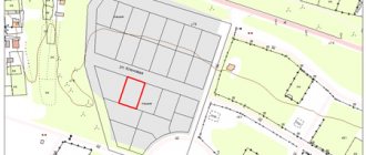
The completed survey plan should contain the following information:
- cadastral number of the plot;
- its size;
- territory boundaries;
- description of neighbors' boundaries;
- location of boundary signs;
- coordinate network;
- scale;
- if necessary, turning points.
It is not always possible to draw the boundary line between sections in a straight line; it can be interrupted and curved on the ground. In such cases, it is necessary to determine turning points that will be landmarks for changing the direction of such a line. If the boundary of the plot is heterogeneous, the boundary plan must include a description of the turning points of the boundaries of the land plot.
What is included in geodetic work
Geodesy is carried out according to the following plan:
- Preparation, which consists of collecting and analyzing documentation characterizing the land plot.
- Inspection of the plot on the ground, determination of the type and methods of work.
- Drawing up a work plan.
- Carrying out shooting.
- Determination of boundaries and their coordination with the owners of neighboring plots.
- Establishing the area of the land plot under study.
- Drawing up a drawing of the territory.
- Legal registration and registration of the results of the work performed.
- Carrying out cadastral surveys and entering information into the land cadastre.
Ordinary people can rarely correctly answer the question, land surveying and geodesy - what is the difference. To many, these concepts mistakenly seem to be synonymous.
The purpose of geodesy is to compile and clarify maps, study the deformation of objects, and other engineering work, which requires knowledge of the characteristics and topography of a certain area.
When surveying in the horizontal plane, the binding occurs in the form:
- establishing the exact location of the territory;
- definition of boundaries and area;
- detecting and indicating the coordinates of buildings and other objects.
It is impossible to carry out these procedures without special knowledge and equipment.
According to some, knowing where to get a catalog of coordinates of turning points of the boundaries of a land plot, you can independently carry out land surveying without the help of professionals. However, accessing such data is not easy. They are stored in the land cadastre database and in the electronic catalog of boundary signs and restrictions.
Only a certain circle of people have access to the catalog. This eliminates the possibility of unauthorized changes in the territories of plots and prevents fraud with land.
Carrying out geo-survey of the site
Geodetic survey is carried out in the following order:
- Studying the results of previous surveys.
- Formation of a plan for new work.
- Obtaining special permission to conduct filming.
- Inspection of the site on the ground and establishment of geodetic networks.
- Photography of all buildings and objects located on the site.
- Research and verification of the obtained data.
- Compilation of a report.
As you can see, to conduct a high-quality geodetic survey, you need an analysis of the available documents provided by the landowner, and a wide range of work carried out by a cadastral specialist.
Features of geodetic work
In accordance with current legislation, the participation of surveyors in construction is not limited to conducting geodetic surveys. Specialists of this qualification carry out a full range of work preceding topographic survey and organized after it.
At the stage of studying a construction project, surveyors study design documents, features of the future facility, and develop a work plan. All these activities are a preliminary examination before the geodesy of the site is carried out.
At the next stage, the topographic survey itself is carried out . Landscape features and other factors that could potentially influence construction processes and lead to changes in plan are examined.
Specialists check the area for the presence of unknown or abandoned communications - water supply or heating pipes, unused structures.
After the topographic survey, the plans are subject to correction, after which the final stage of surveying is carried out in order to clarify and verify the results obtained.
The control point of these activities is the development of a site plan with coordinates, which will allow the successful completion of the construction of the facility.
Surveyors also perform other types of work related to the examination of future construction sites . Thanks to their “field” experience, they can point out design errors, inaccuracies made by the architect, who usually does not take into account the nature of the soil and plans to build walls from materials that may deteriorate in performance due to unsuitable soil.
Specialists can also participate in all construction and installation processes, advise workers in laying communications and strengthening land slopes.
Characteristic features of the geodetic plan
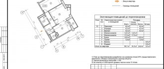
A geodetic plan of a land plot is a detailed map-scheme on which the plot is depicted, and its technical and metric parameters are also indicated.
The document indicates the distinctive features of the territory and objects:
- Relief showing heights and lowlands.
- Water bodies indicating the name, approximate depth and direction of flow.
- Communication lines: roads, electrical networks, gas pipes, communication lines.
- Boundary lines and turning points.
- Green spaces.
- Buildings and fences.
Where are geodetic survey results used?
Such work is necessary for processing documents and transactions during the privatization or purchase of land plots, land surveying of agricultural land.
When planning gasification, topographic and geodetic survey services are also used. Without this work, it is impossible to ensure safety and optimization when installing gas networks.
At the research stage, it is approximately determined:
- Location of gas supply networks.
- Location of existing utilities.
- Ecological environment background.
- Availability of road junctions.
- Depth of underground water.
- Description and assessment of vegetation.
The accuracy of the situational plan of the land plot depends on the accuracy of the survey. Thanks to the professionalism of the operators and the wide capabilities of specialized equipment, topographic surveys are carried out at a high level.
When gasifying land plots, special requirements are imposed on the quality of construction of plans for underground communications.
In order for the binding to geographic coordinates to be as accurate as possible, it is necessary to carry out this procedure using satellite imaging equipment.
What is topographic survey
Topographic survey - work on the study of a land plot to create maps of the area, construction of buildings and utility networks. After they have been carried out, calculations are carried out to make it possible to draw up a topographic plan of the territory in the form of a diagram with annexes containing textual explanations for the map.
Conducting topography is regulated by a number of legislative acts:
- .
- .
Topographic survey is carried out in the following situations:
- Registration of a site surveying project during the development of an allotment. The document indicates buildings, boundary lines and other objects. In this case, it is important to correctly set the points on the land plot along which the border between neighboring plots will pass.
- Laying utility networks. Before this procedure, you should draw up a situation plan for various types of networks. It is developed based on the customer’s request while maintaining the safety of their installation.
- Legal registration of additions to a land plot in amounts not exceeding 10%.
- Reorganization of the site. Most often this is the division of one plot or the combination of several plots into one.
We advise you to read the article “Topographic survey of a land plot”.
When geodetic surveying is necessary - an overview of the main situations
Why is a geodetic plan of a land plot needed? To refer to it in case of difficulties in determining the boundaries and location, coordinates of your property.
Let's imagine that we urgently need a plan for a plot of land. In what are the most common cases do surveyors turn to surveyors for help and is it possible to do it on our own?
Situation 1. Registration of a property for cadastral registration
Geodesy of a site is most often ordered by cadastral workers for registration. They need the exact coordinates of your site. It is almost impossible to make such measurements yourself.
To accurately measure the boundaries of a land plot you will need:
- special skills in working with surveying instruments (as well as the instruments themselves);
- certificates of conformity (your qualifications as a specialist);
- special knowledge on constructing and linking a site to a geodetic network and more.
This is why the demarcation of the territory is carried out by professionals, so that in the cadastral register one plot borders on another, and does not have cross lands. If the geodetic survey was done incorrectly and the coordinates were transferred to the cadastral engineer, there will be legal consequences.
Situation 2. Disputes with neighbors
Often, on dacha plots, neighbors dispute the territorial boundaries of their land plots. A geodetic plan provides for reference to specific coordinates, thanks to which it is possible to absolutely accurately draw the contour of a land plot on the ground. Or even better, remove the boundaries of the land plot in situ.
Let's watch a video on how to resolve neighbor disputes.
In addition, we should not forget about building codes. The construction of structures on a land plot must correspond to certain values and distances from public lands and neighboring territories.
Situation 3. Division or merger of plots
In this case, surveying is necessary for the legal redevelopment of the plots. Moreover, it is better to do this before starting work. Formally, nothing will change, but from the point of view of the law, the boundaries of your plot have been changed, and the cadastral entries in the register must be changed accordingly.
Changing the boundaries of plots is a change in the volume of property, which means it must be regulated by law. Otherwise, the boundaries can be challenged in court by any interested party.
Situation 4. Conducting property transactions with land
In this case, geodetic survey is part of the process of buying and selling real estate. The land must be assessed, and for this a site plan is needed.
In addition, you can sell part of the plot, rent it out, or provide a site for the construction of any structure - all this requires surveying, including engineering surveys for construction.
Situation 5. Determining the area of the site
The most banal and most frequently performed work. In 99% of cases, surveying is ordered to accurately determine the size of the plot and, accordingly, the amount of taxes.
Also, surveys of the area of land are carried out on abandoned lands and on newly developed ones. This work is most often carried out in combination with topographic surveying of the area.
Ways to find out the coordinates of an allotment by cadastral number
To save money, many land users figure out how to determine the boundaries of a land plot by coordinates themselves. It is extremely difficult for a person to do this without the appropriate knowledge and equipment, so it is better to turn to professionals.
There is no point in trying to draw conclusions based on an analysis of available documents, because this can lead to mistakes that will lead to problems in the use of the land plot.
If you have some information about the site, you can try to get the necessary data online using the special service of Rosreestr. It allows you to find out the boundaries of a plot by cadastral number and coordinates.
The first method is used if, when allocating a plot of land, a person was only informed of its cadastral number. The recipient cannot study the plot in kind, because not everyone knows how to find out the coordinates of the points of the land plot by cadastral number. Meanwhile, such a possibility exists.
The coordinates are the latitude and longitude of each of its turning points. Knowing them, you can designate the allotment by.
To find out the coordinates of the site, you need to:
- Visit the map website and click on the search bar. By default, it searches for land plots, since the public cadastral map is most often used to search for plots.
- Enter the cadastral number and click on the “find” button. The program will find the desired area and mark it in yellow.
- Increase the scale to the maximum size so that it is completely displayed on the screen to reduce the error. You can do this using the “+” sign in the lower right corner of the screen.
- Click the cursor on the right corner of the area. Numbers will appear in the search line, which will be the coordinates of the site.
Determining the boundaries of a site using x and y coordinates is a difficult procedure for a non-professional. When usually identifying a site on the ground, people are guided by some characteristic signs: pillars, trees, and so on. However, when surveying the land, the engineer clearly determines the coordinates of the plot and puts them on the cadastral register. In this case, the accuracy of coordinates for a certain category of land must be taken into account.
The need for
Geodetic surveying refers to complex work that begins with determining the geographical location of the object being prepared for construction. The feasibility of the technical and economic location must be taken into account. They determine the quality of the soil and its composition, and whether it is possible to use it as a resource for construction purposes.
In addition to the fact that measuring work on the ground is required for various types of design activities, also in relation to the production of the entire set of geodetic works, it is possible to obtain an accurate layout of the plot, which reflects all the buildings, structures and lines of technological significance located on it.
Sample geological basis of the plan
This plan is called geobasis and its implementation takes place on a scale of 1:500. The period during which this act is considered valid is four years.
During this period, it is necessary to carry out the entire range of design work that needs to be carried out on the site. The result of a geodetic survey can be obtained a plan of the plot, which reflects all its dimensional characteristics, which are linked to objects located on the ground. Data for all types of design of structures and buildings is also reflected.