▼ Topographic survey ▼ Survey scale ▼ Cost of topographic survey ▼ Types of survey
Topographic survey of a land plot (topographic survey of a site) is of interest to many people planning construction in Moscow and the Moscow region. In our company you can order professional services for topographic survey of a land plot, and the survey price will be affordable for both organizations and individuals.
Per plot (10 acres)
Price from: 12,000 rub.
The price is valid until June 4
Call me back Calculate cost
Reviews GeoCompany
Topographic survey - what is it?
Topographic survey is a type of geodetic survey that includes measuring distances and angles, determining coordinates and turning points in order to draw up a topographic plan (map) of the site. This procedure requires turning equipment, modern computer programs and experience of employees.
Topographic surveys, carried out using high-precision geodetic equipment, using aircraft and satellite GPS receivers, allow survey engineers to obtain information about the terrain features, the location of ground objects, above-ground and underground communication networks in the study area. This information is used by designers to draw up working drawings, as well as:
- to obtain a building permit;
- for reorganization of the territory;
- to draw up a diagram of utility lines.
Why is topographic survey necessary?
A topographic survey of a specific area is an important document that must be obtained before planning the development of the territory. It is required for the following purposes:
- Landscaping.
- Obtaining a building permit.
- Approval of the general development project.
- Approval of the urban development plan.
- Expertise.
- Creation of a water utility project.
- Creation of a dendroplane.
- Many excavation and landscaping works.
- Conducting electricity.
- Carrying water.
- Sewerage installation.
- Conducting gas.
- Purchase or lease of municipal land.
- Legal real estate transactions for individuals.
- Reconstruction of structures or communications.
Application of topographic survey of the area
Topographic survey of a land plot allows you to obtain accurate information about the terrain and the presence of underground communications, which, in turn, allows the project team to make informed, correct decisions. Topographic survey is used:
- when updating topographic maps that are more than three years old,
- when conducting geological and environmental surveys,
- when laying communications,
- when working as a landscape designer.
Based on its results, you can create a three-dimensional digital model of the area. Specialists of GeoCompany LLC have photographed thousands of hectares from the Pskov region to Sakhalin.
Topographic survey: how we do it
Topographic survey is a complex of engineering and geodetic work performed to create plans and maps necessary for detailed display of accurate and up-to-date information about:
- terrain;
- above-ground and underground buildings and structures located on the ground;
- green spaces;
- communications facilities (water, gas, communications, electricity, sewerage).
Why do topographic surveys of a plot of land take place?
Drawing up a detailed site plan is required for a variety of land management needs, as well as for landscaping the territory.
Topographic survey is used:
- upon approval of the general development plan, urban development plan and general site plan;
- upon receipt of a construction permit (for commercial organizations);
- to draw up a vertical layout of the site;
- when performing landscape and other landscaping work;
- in case of conducting a land management examination;
- for designing and carrying out communications to the facility;
- during the reconstruction of buildings, structures and communications;
- to register an “addition” to a plot or buy municipal land.
Geodetic surveying is the basis of any construction, so it will definitely be required if you decide to build a house.
Stages of topographic survey of the site
- “Preparatory” stage: includes the collection and execution of preliminary documents, technical specifications are drawn up;
- “Field” stage: specialists visiting the area, conducting topographic and geodetic measurements and direct topographic survey of the site);
- “Desk” stage: a topographic plan is drawn up and all documents are drawn up in accordance with the technical specifications. The received package of documents is transferred to the customer in paper or electronic form.
The validity period of topographic survey is 2 years (according to clause 5.60 of SP 11-104-97 “Engineering and geodetic surveys for construction”).
Upon completion of geodetic work, you receive a professional cartographic image of the object - a topographic plan.
Using standard symbols and designations, it reflects all elements of buildings, vegetation, underground communications and relief that were physically present on the site at the time of shooting.
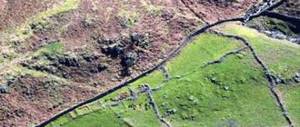
Topographic plan of the Gorki-2 site
Scale of geodetic survey
Depending on the purposes, surveying can be carried out on scales of varying degrees of enlargement. For design, the most common scale is 1:500 with a half-meter height of the relief section. If the purpose of topographic survey is landscape design, then large-scale planning of 1:100 or 1:200 with a 25-centimeter section height is used.
The choice of scale, coordinate grid and level of relief reflection is established at the stage of developing the technical specifications.
What documents are needed for topographic surveying?
The list of documents for placing an order for the preparation of a topographic survey of a land plot is as follows:
- Technical specifications from the customer describing the required work.
- Title documents for the land and buildings of all co-owners.
- Copies of the main pages of the passport - for individuals.
- Copies of constituent documents - for legal entities.
- Technical passport (if available).
- Power of attorney - in case of placing an order through a representative.
Is it possible to do a topographic survey yourself?
Carrying out engineering and geodetic work requires professional skills and special education. Only a certified cadastral engineer or surveyor can take measurements and draw up the necessary documents.
In addition, the work requires high-precision measuring equipment (electronic total stations, GPS equipment, quadcopters, etc.). All measurements must be carried out in accordance with the standards established by law.
In some cases, the owner himself can carry out a number of works to develop the territory. For example, draw up a drawing and plan the site before the subsequent construction of a house. We wrote about this earlier, we recommend that you read it. But in the case of topographic survey, we do not advise you to conduct it yourself. Do not take on this labor-intensive process; land management work of this level should only be performed by professionals.
Equipment and experience
As we wrote above, specialized equipment is needed to conduct geodetic and topographic surveys. The accuracy and quality of the work performed depends on the quality of the instruments used.
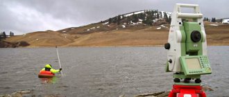
Engineers of the Central Cadastral Bureau in the field
Our company uses equipment from the Swiss company Leica Geosystems for measurements. It has been a world leader in the development of technology and the production of surveying instruments for 200 years.
What kind of equipment do we use?
- Leica TS02 total station is a laser rangefinder . Its important advantages are versatility, high measurement accuracy and a wide range of operating temperatures - from -35°C to +50°C.
- and GS16 GPS receivers . Such devices find signals in the most difficult conditions and adapt to different environmental conditions. Automatically determine which signals to use and which to ignore. This ensures maximum accuracy.
- Ridgid SR-20 Seek Tech Locator. A necessary tool when carrying out work related to the maintenance of underground communications.
Our engineers have over 15 years of experience and are skilled in working with complex measuring equipment. It is experience and quality that give the correct and quick result. That’s why you can safely contact us for filming of any complexity.
The cost and duration of topographic surveys and other geodetic works depend on the volume and complexity of the tasks assigned and are calculated individually in each individual case.
If you want to know the exact cost and terms of work, contact our specialists. To do this, leave a request by phone +7 or fill out the feedback form.
Topographic scale
Typically, topographic surveys are carried out at a scale of 1:500, which is suitable for most design work. Using surveys at this scale allows you to plot on the topographic plan:
- infrastructure available on the land plot;
- communication systems;
- relief details;
- green spaces.
Tree topographic survey is used to draw up plans for the construction of dachas, country houses and other similar objects. Its characteristic feature is that each tree is marked on the plan.
Modern topographic survey of a land plot involves the use of professional geodetic equipment, for example, digital GPS receivers. Our company has its own technical base, and specialists annually undergo advanced training courses. We guarantee prompt and accurate execution of work, and the cost of services starts from 12,000 rubles. At the same time, we do not recommend saving on topographic research and using the services of private owners who do not have SRO approval. An unprofessional topographic survey of a land plot can lead to unsatisfactory results.
What documents are required for topographic surveying?
To survey a land plot you need:
- Technical task. It specifies exactly what actions the specialists will perform.
- Customer's passport. It can also be the passport of another person, a trusted person.
- Constituent documents, if the shooting is ordered by a legal entity.
- Extract from the Unified State Register or installation documentation.
However, other documents may also be required. It all depends on the area in which the land is located. It is better to check with the company’s specialists for a complete list of documentation.
Prices for topographic survey of a land plot
The availability of prices for geodetic surveys depends on the tasks set, scale, and area of the work site. If you need to order a topographic survey, please contact our specialists by phone +7-495-777-65-35 or WhatsApp. We will advise you on price, timing and give all the necessary recommendations regarding the topography of the site.
| plot less than 15 acres | 12,000 rub. |
| plot up to 25 acres | 16,000 rub. |
| reconciliation of borders with the cadastral passport | 8,000 rub. |
Details about prices for topographic survey of a land plot.
Order topographic survey of a turnkey site
Order
What is land surveying?
Topographic survey is a set of works that are carried out to create a topographic map or plan of a certain area.
Moreover, these plans or maps can be of different scales. The documents indicate the features of the land plot, in particular, its size, coordinates, availability of communications, location of structures, elevation changes on the ground in the form of symbols. Topographical survey is an important document, without which it is simply impossible to begin legal construction on the site, to begin connecting to communications, for example, gas, heating networks, sewerage, water supply. In addition, the presented data can be used when drawing up a development project or developing landscape design.
It is worth noting right away that incorrectly done geodetic surveys are fraught with serious financial losses. The data will be of poor quality, so when checking it turns out that everything will have to be redone again. That is why it is better to first contact trusted companies, for example, Engineering Geodesy LLC. Our specialists have extensive experience, the necessary equipment and all licenses for carrying out geodetic work. Therefore, you can be one hundred percent sure of the quality.
Types of topographic survey
In our company you can order the following types of geodetic work:
- landscape,
- façade,
- tacheometric topographic survey.
We also provide services for surveying land plots adjacent to or intersecting with various large objects of artificial or natural origin. When conducting site surveys, intersections with:
- rivers and ravines;
- power lines;
- large communication systems.
When constructing a private house, a topographic survey of the dacha plot is carried out with the boundaries checked using the cadastral passport. If you plan to install a gas pipeline, it is necessary to photograph the area through which it will pass and the adjacent territory, as a result of which we will receive a topographic survey that allows:
- check and study the area;
- measure the height difference;
- receive complete information about the features of further underground and surface work.
Topographic Survey Options
The main parameter of topographic survey is its scale, which is determined by the purpose of creating a topographic map and regulatory documents. The detail depends on the scale, although it is possible to display larger or smaller objects on the plan, again, depending on the purpose of the topographic survey.
Common standard topoplan scales:
- 1:2000 – used for designing large objects, creating situational plans of the area, inventorying forest plantations;
- 1:1000 – for working drawings, digital processing and project creation;
- 1:500 – the main scale for capital construction, landscaping, laying communications; accepted for approval by all authorities;
- 1:200 - convenient for displaying the topographic situation in small areas, including for private use, as well as for geotechnical and survey work (assessing building deformation, foundation settlement).
The choice of the optimal scale, based on the characteristics of the topographic survey object, is enshrined in Appendix B to SP 47.13330.2016.
What documents are required?
To order a topographic survey of the site, you need to contact us by phone +7-495-777-65-35 or WhatsApp. In addition, you must provide the following documents:
- title document;
- terms of reference for conducting surveys (if available);
- available information about previous studies (if available).
The starting point for starting work is the signing of an agreement between the Customer and the Contractor, indicating the type of research, deadlines, and responsibilities of the parties.
Our equipment
Topographic surveys by GeoCompany specialists are carried out using electronic total stations and theodolites. To measure distances, digital levels and laser tape measures are used. The search for utility networks is carried out using special route finders. In addition, we carry out aerial photography of land plots using aircraft, and use information from GPS/GLONASS satellites. Topoplans have high accuracy and are quickly checked by regulatory authorities.
Why is topographic survey carried out? And what does it include?
The importance of topographic surveys cannot be overestimated. Carrying out topographical work is included in the list of responsibilities of cadastral service employees. Without the necessary data characterizing the relief of a land plot, it is impossible to draw up a topographic plan. This is the name given to an image of a site taken on a reduced scale.
Topographic survey is a mandatory stage in the work of any geodetic company. Based on the results of the survey, documents are prepared, both electronic and paper. The finished plan shows the horizontal lines and elevations of the land plot.
Using topographic survey:
- establish geographical boundaries;
- prepare construction sites;
- determine the topography of the landscape.
If there is a need to carry out such work, you should use the services of surveying engineers. This is partly due to the need for special software and modern technology. Legal equipment is used only with the consent of the design services. Thanks to the well-equipped and highly professional staff, an accurate technical report will be obtained.
Stages of topographic survey
Topographic survey is a set of activities that allow you to draw up a map of a site on a selected scale. Filming includes:
- drawing up technical specifications indicating the required parameters;
- visual inspection of the site;
- creation of a plan-height justification (for large areas);
- field work (direct topographic survey of your land plot);
- processing information obtained during field topographic survey, transferring the plan onto paper, converting it into electronic form (office work);
- coordination of the correct application of existing utilities (for objects sent for state examination);
- writing a report on the topographic work carried out;
- if necessary, assessing the quality of work in higher organizations.
At different stages of development of the geological basis in accordance with the agreement:
- a plan is drawn;
- measurements are taken indicating the area;
- descriptions and names are selected;
- boundaries for land management are determined;
- All factors and characteristics that influence the order of responsible construction of structures are taken into account, thanks to which it is possible to assess the general condition of the area.
Finished topographic plans and a report on the survey results are delivered to you by courier or in the office.
Topographic survey technology
Measuring angles and distances using various equipment is the basis of the land surveying process. The more accurate the equipment, the faster and better the work will be done.
Digital tacheometers currently used by surveyors make the survey process as automated as possible: the coordinates of the points are stored in the device’s memory, the software processes the data and produces a drawn plan with the specified parameters. The most important tasks of surveyors with this type of survey:
- understanding of the tasks of a specific topographic survey,
- correct choice of control points,
- placement of control benchmarks taking into account line of sight,
- compliance with the technology of installation of reference points and their registration,
- control of data processing in digital form and adjustment of results based on reconnaissance inspection data, stock materials, comments from operating organizations during the approval process.
Electronic equipment does not in any way replace the qualifications and experience of surveyors, which are necessary to perform topographic surveys at a professional level.
Before the widespread use of digital instruments, other topographic survey technologies were used, for example, scale and theodolite. But now they are practically not used due to the obvious lag in the speed of work and the highest requirements for the qualifications of specialists - the risk of errors during “manual” measurement and recording of results is much higher than in electronic form.
WE WILL COMPLETE AND AGREE A TOPOGRAPHIC SURVEY
- We guarantee compliance with the required deadlines
- We will do everything “from start to finish”
- We will provide free consulting services
Leave a request for a free consultation
and we will contact you shortly
Advantages of ordering topographic surveys in
Professional topographic survey and geological surveys, the price of which is quite affordable for individuals and legal entities, is an important area of activity of our company. If the region in which you plan to build is Moscow or the Moscow region, contact us. We are also ready to travel to another region or region of Russia.
Experts have more than 12 years of experience
The company's staff includes many specialists with experience in conducting topographic surveys.
The best equipment for topographic surveys
We have at our disposal all the equipment necessary to perform such a complex procedure as topographic survey.
Efficiency of all work
We have our own fleet of vehicles and can quickly send a crew for filming to a remote area of Moscow or the Moscow region. It doesn’t matter where your site is located, we are guaranteed to be able to get to it for topographic survey.
Order topographic survey of your object on a turnkey basis
Order
What is topographic survey of a site
Topographic survey is the result of a complex of geodetic work, which is based on measuring the area and drawing up a plan. For this purpose, surveying instruments and specialized software are used. The final result is a topoplan or, as it is also called, a geological basis of a certain scale using approved symbols.
Purpose of topographic survey Generally, topographic survey is divided into two types: before the start of construction to create and approve design documentation and after completion of construction to calculate and identify deviations from the given project.
Main purposes:
- For construction
- Laying of utility networks
- Landscape design
- Registration of land ownership
- Obtaining a building permit
- Territory planning
- Creating a dendraplane
- Cadastral works
- Conducting engineering and geodetic surveys
Executive topographic survey is carried out after carrying out a certain type of construction, laying communication routes, and planning the territory.
The data is used to determine how accurately the construction was carried out and what actual deviations from the design documentation were. Methods of topographic surveys Carrying out topographic surveys depends on many parameters, the purpose of the future geo-base, the area of the object and its location, accessibility. We can name the main methods that surveyors use to obtain field data (measurements).
Tacheometric - at the moment it is one of the main methods of carrying out geodetic work; when performing it, an electronic tacheometer is used, which measures angles, lengths and elevations between certain points on the ground. It refers to the most accurate type of measurement, the error that occurs during tacheometry is up to 2 mm in plan.
Satellite - GPS surveying, this type is gaining more and more popularity; to perform this type of measurement, high-precision geodetic GPS receivers are used, which are capable of calculating the location of points on the ground with an accuracy of 1-2 cm. One person is enough to perform measurements using a GPS receiver. For high-quality and accurate GPS data, you need many related things, calibration of the coordinate system, installation of base stations, and so on.
Filming using unmanned aerial vehicles or quadcopters - this method is not so widespread at the moment.
The main reason that does not allow the use of UAVs is the accuracy of the issued topoplan, about 10 cm. The advantages of aerial photography is its speed in the field; aerial photography is used mainly for large objects with an area of more than 30 hectares. The resulting scales are 1:1000 1:2000 and beyond; for the design and construction of utility networks, aerial photography is currently not fully suitable due to the many variables that can affect the quality of the produced material.
3D scanning - when using 3D scanning, a huge number of points are obtained; it is called a point cloud. The disadvantages of using it are the cost of the equipment and the complexity of its processing. 3D scanning is most often used for measurements inside buildings - premises for developing planning projects and so on. The use of a 3D scanner in the production of topographic surveys is unjustified; the high cost of the equipment and the difficulty in processing the results obtained complicate the drawing process.
Stages of work
It is divided into stages; there are several main ones, which we will discuss below:
the first stage preparatory - at this stage, information is collected about the areas of future topographic measurements, configuration range, relief shape, presence of vegetation and other infrastructure elements.
The optimal shooting method is selected to obtain a more accurate result that will correspond to the technical specifications. In this section we can include the signing of contracts, approval of technical specifications, and so on. The second is direct measurements on the ground (as they say in the field), depending on the method of implementation. A team of surveyors or a surveyor must go to the land plot to take measurements. By measurements we mean determining the coordinates of the main elements (Points): buildings, structures, roads, fences, relief elevations, collecting field data for subsequent processing on the basis of which a topographic plan will be formed. Third - After taking measurements, the data that was received in the fields needs to be processed. Field measurement data is processed using various technical and information programs that make it possible to competently and correctly draw a topographic plan of the area. This type is called deskless, it takes place remotely in the offices of geodetic companies. The end result is a topoplan in electronic form in the AutoCAD program in a certain coordinate system and scale, which is ready for printing and further development of design documentation. To the fourth and final stage we can include such types of work as the coordination of utility networks, this means the passage of services that operate communications that fall into the area of topographic survey to confirm the correctness of their application.
How is topographic survey carried out?
It all starts with the approval of the technical specifications, the purpose of this type of document is clarified, for what purposes it will serve, after the surveyors have received all the necessary information, they go to the land plot, make all the necessary measurements on the ground, then process this data and hand over the received documents to the customer.
- Measurements are made in a specific coordinate system , which is approved by the customer or other legal document. Most often, the coordinate system of the corresponding region is selected, for example MSK50, MSK36. SC implies metric coordinates of the X Y format. The Baltic system of heights is used for the elevation mark; it was adopted back in the USSR. System of heights - the zero count of which is carried out from the zero of the Kronstadt footing rod; from this mark, all the heights of the benchmarks forming the leveling network of Russia are calculated.
- The plan consists of linear point and area objects. Each of the objects is assigned its own individual symbol. Based on this, surveyors take measurements and calculate the coordinates of objects that should be indicated on the topoplan. The measurement includes determining the elevations of the relief and its configuration.
- Processing of field data - Using specialized software, coordinates are calculated to obtain characteristic points of the future topoplan.
- The diagram is drawn by substituting its own symbol for each point and connecting linear objects. All conventional signs have their own characteristic parameters. The use of signs makes the plan easy to read.
- The final stage is transferring the diagram to the AutoCAD where 1 drawing unit will correspond to one meter on the ground.
What tools are used
To carry out geodetic measurements, specialized geodetic equipment is used, which must be certified - verified for compliance with state accuracy standards. Verifications are carried out on equipment once a year, which confirms the suitability of the equipment; if the equipment has not passed verification, it cannot be used.
Basic geodetic equipment:
- Electronic total station
- GPS receiver
- Quadcopter or other aircraft
- Tool for scanning underground utilities (router)
Main scales
The scale varies from the purpose of a specific topographic survey; according to statistics, for design and survey work on an area of up to 100 hectares, a scale of 1:500 is used; it can be increased if the object is linear and its length is more than 10 km. The scale for the topoplan is selected individually based on its application; you can read about the scale and accuracy in our article.
Legislation
- GKINP (ONTA)-02-262-02 Instructions for the development of survey justification and terrain survey using global navigation satellite systems GLONASS and GPS
- GKINP-02-033-82 Instructions for topographic survey on scales 5000, 2000, 1000,500 (approved by the USSR State Administration on October 5, 1979)
- SNiP 11-02-96 Engineering surveys for construction. Basic provisions
- SP 11-104-97 Engineering and geodetic surveys for construction
- SP 11-104-97 part 2, Surveying underground utilities
- Conventional signs for topographic plans of scales 1_5000, 1_2000, 1_1000, 1_500