Continue to next article
It is common for the state to count everything it has. The results of the calculations are recorded in various cadastres. The word “cadastre”, whose origins go back to ancient Latin, has the same meaning in most languages of the world: list, register, list, inventory.
The cadastre is a universal form of recording various types of resources, items, and anything else in general. Cadastres and cadastral registration objects can be very different.
Data on water bodies and water resources is contained in the state water cadastre.
In order to organize effective geological study and integrated use of mineral deposits and rational placement of enterprises for their extraction, a state cadastre of mineral deposits and occurrences is maintained. It contains information for each deposit, characterizing the quantity and quality of the main minerals and the minerals occurring together with them.
There is also a state cadastre of subsoil cavities.
Information about large accumulations of materials formed as a result of the extraction and processing of mineral raw materials has been collected in the state cadastre of technogenic mineral deposits. It stores information about the quantity and quality of man-made minerals, the useful components they contain and the nature of their distribution, as well as many other characteristics.
A systematized collection of information on the origin and physical and chemical properties of various types of waste, systematized at the federal level, is maintained in the waste inventory.
For radioactive waste, an inventory of radioactive waste storage facilities is maintained.
Inventories of animals, fish and...weapons
Even wildlife is of interest to cadastres. An example is the state cadastre of fauna objects. In this case, the cadastre objects are representatives of fauna. The cadastre contains information about their geographical distribution, numbers, habitat, economic use and other data.
The purpose of the cadastre of commercial fish and other aquatic animals and plants in Russia is clear from its name.
There are also quite exotic (at first glance, at least) cadastres. For example, the state cadastre of civilian and service weapons and ammunition, designed to store information about civilian and service weapons and ammunition for them, permitted for circulation on the territory of the Russian Federation.
Goals and objectives
The main task of the State Property Committee is to provide clear data and complete characteristics of all real estate objects for the civilian population, as well as assigning cadastral numbers to all land plots for further manipulations regarding real estate.
You should know: to determine the location of any object, the cadastral engineer must carry out a complete analysis of the building, structure or land plot and subsequently enter the coordinates of the turning points of the corresponding object into the State Property Committee database.
A special feature of the state real estate cadastre is the program of unified database maintenance throughout the Russian Federation, the progress of which consists in the continuous synchronization and updating of all information separately for each plot or property, as well as the prompt public availability and relevance of data for all citizens of the country in need.
The state cadastre maintenance system is required to fulfill such items as:
- recognizing as normative the location (non-location) of real estate items on the territory of the state;
- registration and supervision of the use of property and land, their protection;
- scheme and coordination of land use;
- analysis, assessment of real estate and establishment of appropriate tariffs for its operation;
- application of state registration standards for real estate, namely Rosreestr;
- physical protection and legal persons on the normativity of real estate items;
- availability of publicly available information about a set of actions regarding real estate;
- conducting taxation of registered lands and objects.
The main task of the state. Real estate cadastre - providing interested parties with the necessary materials about objects of registration.
From all of the above, the general purpose of this type of activity is shown - the correct exploitation of all lands and resources of the country. If you have complete information about the status of land plots and real estate, you can manage rationally and make the right decisions regarding their purpose.
What is the state real estate cadastre
A large number of people know better than others the State Real Estate Cadastre (GKN), which is a systematic collection of information about real estate registered in accordance with the law. It also contains data on the passage of the State Border of the Russian Federation, on other borders (between subjects of the Russian Federation, municipalities, settlements), on territorial zones and zones with special conditions for the use of territories and a whole range of other information.
The basis of the real estate cadastre is the land cadastre. Land has special meaning for people. It is the most important natural resource, a necessary material condition for human existence. Many sectors of the economy are inextricably linked with the land, states are formed on it, and bloody wars have not stopped over it for centuries. And also, land is a commodity, the fundamental basis of the land market that plays a huge role in the economy of almost any country.
Historically, the need for a land cadastre arose due to the need to have information about land as an object of taxation. Then he began to be assigned the function of protecting land ownership and property. Today, one of the most important tasks of the land cadastre is the preservation of land as an integral part of the environment.
The state real estate cadastre in Russia has a centuries-old history. Already at the present stage of historical development, work on its creation intensified after the Federal Law “On the State Real Estate Cadastre” came into force, adopted by the State Duma on July 4, 2007.
Technology for maintaining cadastral registration of real estate objects
State cadastral registration of real estate - actions of the authorized body to enter information about real estate into the state real estate cadastre, which confirms the existence of such real estate with characteristics that make it possible to define such real estate as an individually defined thing, or confirm the termination of the existence of such real estate.
Cadastral registration of real estate objects is carried out by the State Property Management Department in accordance with Federal Law No. 221 of July 24, 2007, which came into force on the territory of the Russian Federation on March 1, 2008, and the Procedure for maintaining the state real estate cadastre.
When maintaining cadastral registration of real estate objects in the CMO, authorized persons carry out the following cadastral procedures:
1. Entering information about previously registered real estate objects;
2. Registration of a property in the cadastral register in connection with the formation or creation of a property;
3. Accounting for changes in the property (accounting for part of the property, address of the copyright holder, type of rights);
4. Deregistration of a property from the cadastral register (termination of its existence);
5. Entering cadastral information in accordance with documents received by the CMO from state authorities and local governments in the order of information interaction;
6. Correction of technical and cadastral errors in cadastral information.
Cadastral procedures are carried out on an application basis. This means that all actions of CMO inspectors consist of receiving applications, processing them and issuing the requested information. The GKU technology does not provide for independently obtaining any information that was not provided in the documents submitted by the applicant.
With the receipt of an application by the CMO, the procedure for official document flow begins, which means the strictly regulated and formally controlled movement of documents within the organization from the moment of their receipt (or creation) until completion of execution (sending). Office document flow is a process that begins, accompanies and supports the implementation of the entire technological chain of cadastral registration of real estate. It is intended to ensure mandatory compliance with established technological procedures, as well as the personal responsibility of specialists and officials for the implementation of its individual stages. The technological scheme for carrying out GCU is shown in Fig. 14.
An application for cadastral registration, submitted to the cadastral registration authority by the applicant or his representative in person, is registered on the day of application to the cadastral registration authority in the application registration book, indicating the time of its receipt accurate to the minute (local time), after which a specialist from the cadastral registration authority, authorized to receive applications (hereinafter referred to as the specialist), a mark indicating its registration is affixed to the application. All documents submitted along with the application (including a copy of the document confirming payment of the state fee) indicate the registration number of the application in the application book and the date of its registration.
The application and the documents necessary for cadastral registration are completed in a registration file, which is identified by the registration number of the application, and in the case of receipt of documents for cadastral registration of changes in the property in the order of information interaction - by the registration number of the received documents.
Applicants or their representatives must present the following documents:
— application for cadastral registration;
— a document confirming the authority of the applicant (if the application is submitted by a representative of the applicant);
— originals or duly certified copies of title documents. The originals of title documents attached to the application for state cadastral registration are subject to copying by the cadastral registration authority at the expense of the applicant, after which they are returned to the applicant. The procedure and amount of fees for copying are established by the legal regulatory body within the limits of the funds spent on making copies of the relevant title documents;
- boundary plan (when registering a land plot, its part), as well as a copy of a document confirming the resolution of a land dispute on the approval of the location of the boundaries of the land plot;
| Figure 14 Scheme of the centralized technology for maintaining the Civil Civil Code - technical plan of a building, structure, premises or an unfinished construction site or a copy of the permit to put a capital construction project into operation; - an inspection report confirming the termination of the existence of a property (when deregistering such a property); -a document confirming the relevant powers of the applicant’s representative; — a copy of the document establishing or certifying the applicant’s right to the property; — a copy of a document confirming that the land plot belongs to a certain category; — a copy of the document confirming the established permission to use the land plot; - a copy of the document confirming the change in the purpose of the building or premises. Legal entities submit documents confirming their status (Charter, Certificate of registration of a legal entity with the tax authority, Certificate of state registration of a legal entity) When registering garden plots (Charter of SNT, registered with the tax authority, Certificate of inclusion of SNT in the state register of legal entities, extract from the minutes of the general meeting of the SNT on the selection of the chairman) If an application for state cadastral registration is sent by registered mail, the applicant’s signature and copies of title documents attached to the application must be notarized. The authenticity of an electronic digital signature is confirmed in accordance with Federal Law No. 1-FZ of January 10, 2002 “On Electronic Digital Signatures”. Electronic documents are presented in the form of files in XML format, created using XML schemas located at: www.rosreestr.ru Verification of documents provided for cadastral registration. Information about real estate objects and documents containing them are checked to determine the absence of grounds provided for by law for suspension and refusal of cadastral registration. At the same time, the presence of a temporary status of information in relation to the land plot from which the allocation was made is not a basis for refusal to carry out cadastral registration of a land plot formed on account of the land share. Types of inspections carried out: verification of the applicant’s credentials; checking for completeness of documents; checking documents according to the form and content of information required for cadastral registration; checking for compliance with the State Tax Code information, including graphic display. Applications for state cadastral registration are not subject to acceptance in the event of: - absence of documents provided for in parts 4 - 6 of Article 14 of this Federal Law; - if the application and the documents attached to it have erasures, additions, strikeouts or other corrections, and also if these corrections were made in pencil or have serious damage that does not allow their content to be clearly interpreted; - if the application does not meet the requirements of parts 1 and 2 of Article 14 of this Federal Law. 3. On the acceptance or refusal to accept an application for state cadastral registration, the cadastral registration authority on the day the relevant decision is made: 1) makes an appropriate entry in the document accounting book; 2) hand over to the applicant personally against signature or send him by registered mail a notification of acceptance of the application or refusal to accept it, enclosing the documents submitted by him and a list of attachments. The document verification protocol contains a conclusion for each type of verification, as well as identified grounds for suspension or refusal to conduct cadastral registration. If the documents provided by the applicant allow the necessary information about the land plot to be entered into the State Property Committee, the authorized official of the cadastral registration body makes a decision in writing (a special form) and registers it in the registration and control form. The original of the decision is filed in the cadastral file. Types of decisions: 1) on entering information about previously registered real estate objects: 2) on registering a real estate object for cadastral registration; 3) on accounting for changes in a property (change or deregistration of part of a property, as well as on recording the address of the copyright holder): 4) on deregistration of a property: 5) on entering information into the State Property Committee in accordance with documents received in the order of information interactions; 6) on the correction of technical and cadastral errors in cadastral information. When performing cadastral procedures related to cadastral registration, taking into account changes, deregistration of a property, a decision may be made: 1) to suspend cadastral registration: 2) to refuse to carry out cadastral registration. When entering information about previously registered real estate objects, as well as those received in the order of information interaction, a decision may be made 3) to refuse to enter the relevant information when performing cadastral procedures. related to the correction of a technical error in cadastral information, a decision may be made 4) to refuse to correct the technical error. When checking documents submitted in order to eliminate the grounds for suspension of cadastral registration, the presence in the submitted documents of information necessary for the resumption of cadastral registration is checked, as well as compliance with the established period for such suspension. The results of the inspection are documented in a protocol, which reflects the decision made for each indicator of the inspection. The fact of an inspection, including its individual indicators, is confirmed in the AIS of the State Property Committee by indicating the surname and initials of the authorized official of the cadastral registration body and the date of entering information about the property. The inspection protocol and the draft decision are sent to the official authorized to make decisions (clause 18 of the Procedure). This official has the right to change the inspection protocol, certifying the changes with his signature. The last name and initials of the authorized official of the cadastral registration body, as well as the date of signing the inspection protocol and making the corresponding decision, are entered into the AIS of the State Property Committee. The inspection protocol drawn up on paper and the corresponding decision, prepared using a special form, drawn up in the manner prescribed by the legislation of the Russian Federation, are placed in the accounting file. The implementation of cadastral registration is suspended if: 1. There are contradictions between the information about the property contained in the documents submitted by the applicant for such cadastral registration and the cadastral information about this property (except for cases where changes are made during such cadastral registration in the specified cadastral information). 2. One of the boundaries of the land plot, for cadastral registration of which an application has been submitted, crosses one of the boundaries of another land plot, information about which is contained in the state real estate cadastre (except for the case if the other land plot is a converted real estate object). 3. The location of the premises for cadastral registration of which an application has been submitted, in accordance with cadastral information, partially or completely coincides with the location of another premises (except for the case if the other premises is a converted real estate object). 4. The documents necessary for cadastral registration have not been submitted. If the decision to suspend is made in accordance with paragraphs 1, 2, 3, simultaneously with the decision, the boundary plan, technical plan or survey report submitted along with the relevant application is returned to the applicant or his representative for revision. The decision to suspend the implementation of cadastral registration is made for a period until the circumstances that served as the basis for the decision to suspend are eliminated, but not more than for three months. This decision is issued to the applicant or his representative personally against signature, or sent by mail with a list of the contents and with a receipt notification to the postal address specified in the application. If the violations are not eliminated, a decision is made to refuse to carry out cadastral registration. 1. If the documents submitted by the applicant for state cadastral registration (removal from state cadastral registration) cannot confirm his authority to submit such an application, the cadastral registration authority suspends the state cadastral registration for one month. If the applicant fails to submit the relevant documents within the specified period, the cadastral registration authority makes a decision to refuse to carry out state cadastral registration. 2. Upon receipt of documents confirming the authority of the applicant, the cadastral registration authority checks the compliance of the act of formation with the requirements of the legislation of the Russian Federation, and also determines the compliance of the information contained in the act of formation with the information contained in the state real estate cadastre. In the event of a discrepancy between the act of formation and the requirements of the legislation of the Russian Federation or a discrepancy between the information contained in the act of formation and the information contained in the state real estate cadastre, the cadastral registration authority suspends the state cadastral registration for two months and sends a notification to the applicant and the cadastral engineer who compiled the act of formation. with justification for their decision and recommendations for finalizing the documents submitted for state cadastral registration. The cadastral engineer who drew up the act of formation must, within two months, at his own expense, finalize the act of formation and submit it to the applicant and to the cadastral registration authority. Otherwise, the cadastral registration authority, after the expiration of the period for which the state cadastral registration is suspended, makes a decision to refuse to conduct the state cadastral registration, of which it notifies the applicant, the cadastral engineer who drew up the act of formation, as well as the self-regulatory organization of which the cadastral engineer is a member . State cadastral registration may be suspended on the basis of a judicial act for a period established by this judicial act. Suspension of state cadastral registration interrupts the period established by Part 3 of Article 17 of this Federal Law. If a decision is made to suspend or refuse to carry out state cadastral registration, the cadastral registration authority makes an appropriate entry in the document book. A notice of suspension of state cadastral registration or refusal to conduct it is delivered by the cadastral registration authority to the applicant personally or sent by registered mail within five working days from the date of making the corresponding entry in the document register. The decision to suspend or refuse to carry out state cadastral registration may be appealed in court. A decision to refuse cadastral registration may be made if: - the application for cadastral registration or the documents required for cadastral registration in form or content do not comply with the requirements of this Federal Law; -an improper person applied for cadastral registration; - the real estate object, for cadastral registration of which an application has been submitted, is formed as a result of the transformation of the real estate object and the division or allotment of a share in kind or other action taken during such transformation is not allowed in accordance with the requirements established by federal law; - a real estate object is formed as a result of the transformation of a real estate object and information about such a converted real estate object entered into the state real estate cadastre is of a temporary nature; - the period for suspension of cadastral registration has expired and the circumstances that served as the basis for the decision to suspend have not been eliminated; - the size of the land plot does not comply with the requirements for maximum (maximum and minimum) sizes of land plots established in accordance with land legislation; - a land plot is formed as a result of the transformation of a land plot and the size of the latter in connection with this transformation does not comply with the requirements established in accordance with land legislation for the maximum minimum sizes of land plots; - access to the land plot (passage or passage from public land plots), including through the establishment of an easement, is not ensured; - the land plot is formed as a result of the transformation of the land plot and, in connection with this transformation, access to the latter will not be provided (passage or passage from public land plots), including through the establishment of an easement; - one of the boundaries of the land plot crosses the border of a municipal entity and (or) the border of a populated area; - a land plot is formed as a result of the transformation of land plots, and these converted plots do not belong to the same category of land, with the exception of cases established by federal law; - in connection with a change in the area of the land plot and (or) a change in the location of its boundaries; - the area of the land plot, determined taking into account the requirements established in accordance with this Federal Law, will be greater than the area, information about which is contained in the State Property Code, by an amount greater than the maximum minimum size of the land plot established in accordance with land legislation for lands of the corresponding intended purpose and permitted use, if such a size is not established, for an amount of more than 10% of the area, information about which regarding this land plot is contained in the State Property Code; - the procedure for agreeing on the location of the boundaries of land plots has been violated, with the exception of cases where these boundaries are recognized as specified in the procedure for resolving a land dispute; The cadastral registration authority makes a decision to refuse to deregister a land plot if such land plot is not convertible and is not subject to deregistration in accordance with this law. The cadastral registration authority makes a decision to refuse to carry out cadastral registration within 20 calendar days (Part 1 of Article 17 No. 221-FZ). This decision to refuse is issued to the relevant applicant or his representative personally against signature, or no later than the business day following the fifth business day from the date of expiration of the specified period, sent by mail with a list of the attachments and with a return receipt to the postal address specified in the relevant application. If a decision is made to register with the state cadastral register, the cadastral registration authority: |
assigns a cadastral number to the new cadastral registration object;
makes appropriate entries in the state real estate cadastre;
approves the cadastral passport containing the necessary information or makes changes to it.
The date of registration of an object for state cadastral registration is the date of adoption of the legal act on registration for state cadastral registration. The original of the decision is placed in the corresponding cadastral file (nomenclature file). If, as a result of the transformation of a real estate object, several real estate objects are formed or documents submitted to the cadastral registration authority in the order of information interaction indicate a change in information regarding several real estate objects, the decision is drawn up in the form of one document.
Questions for self-control
- What is meant by state cadastral registration of land and for what purpose is it carried out?
- The main sections of the State Committee for Knowledge and their contents.
- What procedures are carried out in the CMO and what decisions are made on them?
- What checks are carried out during the examination of documents?
- In what case can a suspension in the Civil Code of Ukraine take place?
- What is the basis for refusal to apply to the State Civil Institution?
BIBLIOGRAPHY
Basic principles of maintaining the state real estate cadastre
There are several such principles. One of the most important ─ due to the peculiarities of Russia (huge area, presence of a large number of constituent entities of the Federation) ─ unity of technology throughout the country.
The principle of comparability of cadastral information with information contained in other state information resources greatly helps the successful maintenance of the cadastre.
The principle of continuous updating of the information contained in it allows the state real estate cadastre to keep up with life in the truest sense of the word.
The principle of universal accessibility is extremely important for citizens. The cadastral information contained in the State Property Committee is open, with the exception of those access to which is limited by law.
The federal executive body that carries out the functions of providing public services in the field of maintaining the state real estate cadastre and carrying out state cadastral registration of real estate, as well as the functions of state cadastral valuation, is the Federal Service for State Registration, Cadastre and Cartography (Rosreestr). Her responsibilities also include state registration of rights to real estate and transactions with it, issues of land management, geodesy, cartography and others.
Specifics of cadastral registration
The initiator of the formation of a cadastral registration object is the existing or potential owner. This happens in the following case:
- when registering all real estate or part thereof;
- when the characteristics of plots with a cadastral number change.
The interested party enters into an agreement with a cadastral engineer to carry out cadastral work. As a result, the boundaries of the site are determined, a boundary plan is drawn up, and a package of documents is prepared for filing an application for registration. A change of address or a change in the category of a land plot are not grounds for the formation of an object.
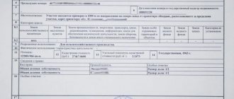
Example of a cadastral passport of a land plot
The owner of the plot receives an extract from the cadastre in the form of a cadastral passport, and since 2015 in the form of a boundary or technical plan. This document, which lists the characteristics of the property and is necessary when concluding transactions with it.
The reliability and relevance of information about a real estate property is achieved by maintaining the State Property Committee in accordance with the following principles:
- Unity. Methods and technologies for generating, receiving and providing information are the same for any real estate and throughout the Russian Federation.
- Public availability. Any subject can obtain the necessary information in full, and the data is updated systematically and continuously. Information is available upon request and is current as of the date of discharge.
Example of data on a land plot from a cadastral extract - Comparability. The approach and methodology for collecting information in the cadastre and other state registers is the same, therefore the data obtained from any state resource is comparable. In addition, interdepartmental data exchange ensures the relevance of data from any register and simplifies real estate transactions.
Cadastral registration is carried out in electronic or paper form. Electronic provides rapid processing and exchange of data and is more convenient and promising. But if differences are found, printed materials are preferred, which are stored in archives and are not destroyed while the object exists.
GKN is a multi-purpose system containing information characterizing objects from a single plot to the land fund of the whole of Russia, which is maintained at several levels:
- Municipalities. The cadastre receives data on real estate located within the same municipality and included in it. An inventory and assessment is carried out, land management work is carried out, and maps of the territories are drawn up.
An example of a layout of a land plot on a cadastral plan of the territory - Subjects of the Federation. This is information necessary for government administration and control. It concerns municipalities, borders, and objects belonging to a constituent entity of the Russian Federation within a region, district or republic. At this level, regional laws concerning land relations are adopted and the work of regional cadastral chambers is monitored.
- Federation. These are all real estate objects located on its territory, federal subjects, borders, including state borders. At this level, Rosreestr approves the norms and rules for maintaining cadastral registration, automates it, and manages the activities of regional structures.
Registers of subjects are included in Rosreestr and include municipal cadastres. At the municipal level, the formation of a cadastre, registration of real estate and information services to the population are underway.
Structure of the state real estate cadastre
The state real estate cadastre consists of three sections: register of real estate; cadastral affairs; cadastral maps.
The register of real estate objects is a systematic collection of records about real estate objects.
The set of documents on the basis of which information was entered into the state real estate cadastre forms cadastral files.
On cadastral maps, in graphical and text form, information about real estate objects entered into the state real estate cadastre, about the passage of the State Border of the Russian Federation and other borders, about territorial zones, zones with special conditions for the use of territories, the cadastral division of the territory of the Russian Federation is reproduced, the location of reference boundary points is indicated networks.
What is GKN
The document of the state real estate cadastre (GKN) is a set of data containing information about all registered real estate objects of the Russian Federation, namely: land category, cadastral number, area, cost, location, etc. Such data about the object confirms the status of its existence as officially registered and registered accordingly.
In order to carry out any kind of transactions with property, it is necessary to obtain an extract with the data described above from the State Property Committee.
There is a specific profession for carrying out all operations related to real estate - cadastral engineer. A person in this profession is engaged in land surveying and restoration of borders. A cadastral engineer can also work with documentation related to legal proceedings. In more detail, this highly qualified specialist can recognize old and new cadastral numbers, encode and decipher them, change and adjust all information about the property, and also prepare them for registration.
The information in the cadastre database is divided into two classes of indications:
Basic:
- form of property (building, structure, premises, etc.);
- cadastral number, as well as the date of its entry into the state cadastre. The date of entry of the individual number stipulates that the registration decision is implemented within 20 working days from the date of submission of the relevant application;
- location of the boundaries of the visual property. The essence is about the visually displayed map and plan of this property. All information about the total volume of the site area is in a special document called a technical plan;
- cadastral number of the building or structure, information about the premises, a specific floor and a detailed description of the territory of this floor.
Additional:
- complete information about the location of the object (city, municipality, coordinates, etc.).
- papers providing complete information about the value of the property, including the date of determination of the established and approved amount;
- postal or email address for contacting the owner of the property;
- data of the engineer performing cadastral work at the site.
Transition from land cadastre to real estate cadastre
In Russia, cadastral supervision has been carried out since 1765. When a special commission was created, records of land and land surveying began. This information was entered into a special book, which described the size of the land.
In 1861, in connection with the abolition of serfdom, payment for land underwent some changes. Thus, after the implementation of certain reforms, there was a need to study the principles of management, analysis and identification of benefits from land. Simply put, there was a course of action that ultimately led to more accurate statistics. This is how the zemstvo cadastre was formed, which operated without changes until 1917.
During the Soviet era, there was no cadastral registration as such, since the land was the property of one large country. After a small legal reform in 1965, accounting began to be carried out using planning and cartographic materials, which depicted the boundaries of land management territories.
In today's Russia, serious changes took place already in 1991, when the State Duma adopted new reforms and codes. The main change was the ability to appropriate personal property at the legislative level, as well as take any action regarding real estate (sale, rent, etc.). In 2007, Law FZ-221 “On the State Real Estate Cadastre” was adopted; with a number of amendments and changes, in 2021 this law was introduced into Law FZ-218 and adopted for execution. As a result, the structure of public accounting in the country was improved.
Until 2008, many changes took place in the country, the purpose of which was to systematize real estate, which resulted in the licensing of cadastral activities and the transition from the land cadastre to the real estate cadastre.