Land is the main wealth of people, but it is not ideal. In different climatic zones, areas differ in height, soil composition, and landscape features.
To identify the features of a particular area, geodetic work is carried out. These events are necessary for proper and competent planning of house construction.
Knowing about all the “surprises” of a particular area, you can avoid many negative phenomena in the future - damage to utility lines, risks associated with soil shrinkage, flooding due to excess groundwater levels.
Geodesy of a land plot - what is it in the general sense? This is a set of measuring works that make it possible to determine the parameters and shape of a land plot, analyze existing facilities, and examine the structure of the soil and underground communications.
In the process of conducting geodetic research, a three-dimensional coordinate system is compiled to develop a mathematical model of a given area.
Geodesy within the legal framework
Geodetic work on the ground is carried out in accordance with the requirements specified in the following regulatory legal acts of the Russian Federation:
- Law No. 122 “On state registration of rights”;
- SNiP 11-04-2003 “Instructions on the procedure for development, coordination, examination and approval of urban planning documentation”;
- Order of the Ministry of Economic Development No. 582 of December 31, 2009 “On approval of types of boundary signs”;
- SP 47.13330.2012 Engineering surveys for construction.
Geodetic surveys of land plots can only be carried out by specialists with the appropriate education and who have a license and permits to perform certain types of work. This is necessary for the legal justification and legitimacy of the documentation provided.
What does modern geodesy do?
Today, when conducting geodetic and land surveys, the following work is performed:
- The coordinates of the site boundaries are calculated and given in detail;
- Boundary signs of the established pattern are installed;
- Documents are issued confirming the authenticity and legality of the establishment of boundary marks;
- The exact area of the surveyed territory is calculated;
- Detailed topographic maps of the land plot are compiled;
- A boundary plan of the land plot is drawn up.
Depending on the purpose of geodetic surveys, the list of studies may be adjusted. For example, when it is necessary to establish the exact location and boundaries of a site, only planned measurements are carried out. If it is necessary to conduct a topographic survey of the territory, in addition to horizontal measurements, high-altitude surveys are carried out, giving an accurate description of the relief of the surveyed territory.
Goals of geodetic work
Geodetic surveys on the ground are most often carried out to obtain permission to build objects. However, the scope of practical application of land plot geodesy is much wider.
Geodetic work is also carried out for the following purposes:
- land surveying;
- division/merger of plots;
- cadastral registration;
- purchase/sale of land;
- designation of new borders;
- recognition of the site as ownerless.
In fact, geodetic work is the main activity in any land transaction . However, they are carried out not only for the purpose of obtaining legal clarity, but also in order to obtain important information about the condition of the land plot and bring it into accordance with the general topographic plan of the area.
Geodesy is required not only for lands intended for “individual housing construction,” but also for areas from other categories: recreational resources, farming.
The role of geodesy for construction is colossal. As-built survey allows you to determine the optimal location of the object relative to the soil.
The building must meet a number of requirements:
- the house should be located as close as possible to communication lines;
- the building must be correctly located relative to the cardinal directions;
- it is important to comply with the type of soil and topography;
- the distance to neighboring objects is taken into account.
Geodesy makes it possible to determine the need for serious excavation work on a site, for example, to develop a proper drainage system.
In nature, you rarely find perfectly flat areas. There is always at least a slight bias. Therefore, it is important to position buildings so that water from the soil does not wet the foundation. This is especially important for facilities built in low-lying areas where water flows from higher points.
Why else is land surveying needed? This procedure is also carried out when creating landscape design . An accurate site plan allows you to plan the placement of all structures and objects.
Many people are still concerned about whether it is really necessary to do a survey of the site before building a private house. The better the engineering survey is carried out, the better the justification for the design of the future house. And in order for the documentation to be in order, it is imperative to order a geodesy of the land plot.
It is necessary to understand that geodesy of a land plot is one of the stages in carrying out cadastral work . Before this, planning is carried out, and after that - desk processing of information and research.
Geodesy (geology) of the site before construction begins
Home » Geodesy (geology) of the site before the start of construction
Geodesy (geology) of the site before construction begins
The surface of the earth on which all construction projects are being built is a rather complex place physically and geologically.
Differences in: – relief; – soil composition; – mechanical and chemical properties; – the presence and quantity of groundwater and many other characteristics.
All these features of a particular location must be taken into account when building a house. The science of geodesy studies all of the listed properties of a terrain.
All characteristics of the terrain must be known and taken into account both during construction and at the design stage in order to calculate the most reliable and economically efficient house design. To clarify them, a geodesy of the site is carried out before construction begins. The purpose of engineering and geodetic research is to provide designers and builders with comprehensive information about the features of construction in a particular area.
Reasons for conducting geodesy of the site
Without geodetic and topographical surveys on the ground, not a single house project can be developed and agreed upon. Based on the data obtained as a result of research, technical conditions for construction are formulated. Moreover, not only the cost of construction, but also the durability of the building and the safety of living depend on the accuracy and reliability of this data. On their basis, the house is also vertically linked to the terrain, the zero mark and the foundation mark are determined.
Conducting topographic and geodetic surveys is a norm prescribed by current legislation. Research results are a prerequisite for laying communications.
Topographic and geodetic plans are an image on paper of a horizontal projection of the terrain on a scale of 1:500 without taking into account the sphericity of the Earth. This scale is the most common today and is the standard for coordinating and protecting a future project. On the general plan of the area or settlement, according to the research data, the axes of the designed building or structure are linked to the signs of the geotechnical map.
How is site geodesy done?
Geodetic reconnaissance, which will later result in plans and projects on paper, initially involves working on the ground. A team of surveying engineers equipped with special equipment goes to the construction site of the house. First of all, this is a drilling rig on the chassis of a special vehicle. Its task is to drill a certain number of wells sufficient to determine the composition and nature of the soil.
The location and number of wells are determined by the design engineers. As a rule, these are points in those places where the foundation of the future building will bear the greatest load. This is important, since in order to correctly select the type of foundation, it is necessary to know the characteristics of the soil on which they plan to build the structure.
The first stage of drilling is static sounding. A metal rod is pressed into the ground, and the frontal and lateral resistance of the soil is determined by how it behaves under load. Probing occurs until the rod begins to lose the rate of penetration required by building regulations. Parameters of frontal and lateral pressure are entered into the drilling log.
Subsequently, when drilling at the site, soil samples are taken, the depth of the aquifers and the nature of the groundwater are studied. Also, as part of the study of the territory, the following is carried out:
– collection of cartographic materials; – office work; – coordination of installed communications with operation services; – preparation of a technical report and submission to the design organization and urban planning authorities.
Separately, it should be said that all geodetic work is carried out in the warm season. And not during the spring snowmelt. Summer and early autumn are optimal. In winter, geodetic work is not carried out. In administrative terms, to conduct a geodetic survey of a site for building a house, you need the “go-ahead” of local governments and the architectural department in charge of the given territory. Survey work must be carried out by an organization that has the appropriate certificate and state license.
Of course, when ordering geodesy of a site for building a house, you need to be sufficiently aware of prices. Each organization has its own, and the list of positions produced within the framework of such work can take up more than one sheet. Some average market prices for geodetic work are shown in Table 1.
Table 1. Cost of geodesy of a site for building a house
| Works | Price, UAH |
| Laying out axes, setting out site boundaries, setting out benchmarks | 2000 |
| Realization of a land plot (price per point) | 300 |
| Project for changing the purpose of a land plot | 6500 |
| Topographic survey (price per working day) | 900 |
| Mapping out the boundaries of a land plot (price per point) | 250-350 |
| Topographic survey of areas up to 30 acres | 2000-2500 |
| Topographic survey of areas up to 12 acres | 1000-1500 |
| Geodetic study of the site for the foundation to a depth of 10 m to a perimeter of 8x8 m | 4000 |
| Geodetic study of the site for the foundation to a depth of 10 m to a perimeter of 10x10 m | 4500-5000 |
| Full geodetic support for the construction of a facility with an area of up to 1000 square meters. m. (price per month) | 20000 |
| Assignment of a cadastral number of a land plot | 1600 |
Result of site geodesy
When field work and laboratory studies are completed, a report is prepared based on them, which contains comprehensive information on the given territory. Based on the drilling data, so-called desk processing is carried out. Its result is a report on the engineering and geological conditions at the site of the proposed construction. This report should include:
– description of engineering and geological conditions; – technical conclusions; – text applications; – graphs, summary list of indicators of physical properties of soils; – copy of the license; – description of completed wells; – analysis of water extract from the soil for its aggressiveness towards concrete; – graphic applications of engineering-geological section; – well location plan; – hydrogeological maps; – bedrock roof map; – geophysical profiles, etc.
Based on the results of these studies, the architect or engineer develops the foundation design. This will eliminate unnecessary costs during construction and is a significant guarantee that the house will not settle.
What if the site is not surveyed before construction?
The question may seem somewhat naive. But, as practice shows, the desire to save money is expressed not only in the use of Chinese materials and hiring covens. There are many attempts to save on geodesy, for example, to make a foundation similar to that of a neighbor or to use topographic maps made in this area years earlier.
However, geodetic research is precisely part of the preparatory work for the construction of a house, the savings on which most often “backfire.” At best, this results in the fact that three times more money is spent on repairing walls and strengthening the foundation than was saved on survey work. The foundation of the house must be strong and adapted specifically to the specific type of soil.
Refusal to geodesy the site leads primarily to incorrect calculation of the foundation. That is, the foundation will be either too expensive or not reliable enough. The consequences of such mistakes usually do not take long to arrive. This may result in subsidence of the foundation, the first signs of which may be jammed doors, cracking glass in windows, or peeling plaster.
The lack of data on the characteristics of the site can lead to the appearance of water in the basements due to insufficient waterproofing or close groundwater levels. Errors may be made when arranging drainage systems on the site or incorrect installation of storm drains, not to mention the location of the septic tank.
Problems may also arise during utility lines. For example, if water pipes end up at the depth of groundwater, then in winter these pipes may collapse due to freezing. The lack of geodetic data may simply delay the start of construction work. Finally, in a bad case, everything will affect the construction and landscape design in general (you can read about the features of landscape design of a country house in another article).
Similar articles
- Groundwater - combating groundwater
Choosing a plot of land for construction is a rather complex issue, due to the large number of factors that can influence the decision. This is distance from highways, communications, natural settings... - Design of prefabricated buildings is the basis for construction success
Prefabricated buildings and structures made from modern materials are a reasonable solution for industrial construction. An increasing number of customers are choosing prefabricated building technologies... - Landscape design of a plot
Every person who owns a country plot strives to make it as comfortable and cozy as possible. Before proceeding with the actual registration of your...
Features of geodetic work
In accordance with current legislation, the participation of surveyors in construction is not limited to conducting geodetic surveys. Specialists of this qualification carry out a full range of work preceding topographic survey and organized after it.
At the stage of studying a construction project, surveyors study design documents, features of the future facility, and develop a work plan. All these activities are a preliminary examination before the geodesy of the site is carried out.
At the next stage, the topographic survey itself is carried out . Landscape features and other factors that could potentially influence construction processes and lead to changes in plan are examined.
Specialists check the area for the presence of unknown or abandoned communications - water supply or heating pipes, unused structures.
After the topographic survey, the plans are subject to correction, after which the final stage of surveying is carried out in order to clarify and verify the results obtained.
The control point of these activities is the development of a site plan with coordinates, which will allow the successful completion of the construction of the facility.
Surveyors also perform other types of work related to the examination of future construction sites . Thanks to their “field” experience, they can point out design errors, inaccuracies made by the architect, who usually does not take into account the nature of the soil and plans to build walls from materials that may deteriorate in performance due to unsuitable soil.
Specialists can also participate in all construction and installation processes, advise workers in laying communications and strengthening land slopes.
What is a geodetic survey of a plot of land?
In essence, geodetic research is nothing more than drawing up a digital model in a three-dimensional coordinate system, which allows you to create an extremely clear mathematical model of any area on which further construction will be carried out. The length of all objects located nearby the site allocated for construction, their height and, of course, width are measured. It is on the basis of these data that the area of the future construction site and its nominal volume are determined. Geodetic studies will take into account the features of the terrain on which construction will be carried out, and most importantly, elevation differences, which have a direct impact on the design.
Without geodetic research, it is simply impossible to determine the real boundaries of the buildings that will be located on the site. Geodetic work defines clear boundaries of the plot, or area, beyond which the developer should not go. The documentation certainly indicates the boundaries using the existing coordinate system, and without a surveyor it is impossible to determine them, and the papers, without the assurance of such a specialist, will simply not be valid. It is surveyors who bring all land plots into reality before they become someone else's property.
Stages of engineering geodesy
Topographical surveying on the ground comes down to compiling a set of points, each of which differs in its own coordinates and has its own deviations in height. Geodetic points form coordinates that are determined by the Cartesian system. The height is determined by points called benchmarks.
The technique for conducting topographic surveys is approximately the same, but research is carried out in accordance with the following stages:
- Preparatory - registration of contractual relations between the customer and the contractor with approval of the technical specifications. At this stage, employees of cadastral companies study archive materials to obtain information about geodetic work that was previously carried out in the designated area.
- Field surveys - research of objects located on the territory, carrying out as-built surveys.
- Office processing is the final stage, during which topographic maps and specialized plans are drawn up indicating above-ground and underground communications, and reports on the results are written.
In the process of engineering and geodetic surveys, a grid with a fixed pitch is applied to the terrain plan, and a drawing of the alignment base is drawn up. One step is three times less than the smallest parameter of the object being built. The grid axes are parallel to the axes of the structure.
The drawings record in detail all differences in height and cardinal direction, and indicate the connection to local and national points. In its natural form, a set of reference points is formed, with which you can measure all the key points of the drawing from 2 positions.
In the process of marking work, the axes and boundaries of the object are determined. After fixing the planned and high-altitude arrangement of structures in the project, the following actions are performed:
- the zero point and boundary lines are plotted;
- the dimensions of the pits for the foundation are determined
- the location of auxiliary buildings is indicated;
- Landscape design poles are installed.
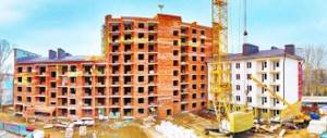
Geodetic survey is carried out at the stage of construction of the structure box . After the foundation shrinks or interfloor partitions are installed, a repeat executive survey is scheduled for the original key points. This is how the correspondence of the design forms, positions and forms with the natural ones is determined.
Control measurements are carried out in the same manner as topographic surveys, but only 2-5 years after the building is put into operation. The purpose of these studies is to confirm the structure and forms of the adjacent relief to the standards and the absence of deviations.
Choosing a methodology for surveying land plots
The selection of methods for photographing land plots is generally carried out based on commercial efficiency, which depends directly on the size of the territory under consideration, its total population and the diversity of the terrain.
Definition 1
Hydrotopographic survey of a territory is a set of engineering and geodetic activities, as a result of which a survey sample of the territory plan is created.
This type of geodetic survey is carried out using photographic, aerial and above-ground mechanisms. Above-ground methods include tacheometric, linear, theodolite and photo-theodolite surveys. Aerial phototopographic survey is carried out by professionals using combinational and stereotopographic techniques.
Note 2
Now, when the activity is carried out on a decent-sized territory, an aerial phototopographic type of survey is considered financially appropriate.
In the case when it is necessary to photograph small plots of land, then, due to the high cost of flight survey procedures, aerial photography turns out to be financially unsuitable; for this reason, in these situations, time-lapse photography is used. Tacheometric survey is carried out in the case when the fixed terrain of the earth has an elongated character with a small width. This can often be observed during construction work of linear objects - communication networks, trunk structures, electrical transmission structures or pipeline networks.
Theodolite surveying is used mainly when recording areas with permanent buildings. This survey consists of all the details of the façade views of structures, neighborhood areas and driveways. In engineering and geodetic activities, scale surveys are often used, as well as tacheometric surveys for agricultural construction. Theodolite survey includes the following stages:
- Desk preparation of building materials and design documents.
- Surveying the area and recording installation points with geodetic marks.
- Field measurements.
- Desk analysis of results.
During a theodolite survey, the active process depends on the actions of theodolite moves - figures with the help of which you can correctly determine the dimensions and lines of rotation between objects. These components may turn out to be disconnected - an elongated transverse course, the beginning and end of which are contained in places of geodetic confirmation of the highest order. For this move, the angular dimensions under all conditions correspond to the places of survey calculations, called adjacent ones.
Is it difficult to figure it out on your own?
Try asking your teachers for help
Solving problems Tests Essays
What tools are used for geodetic surveys
The most classic instrument used by surveyors is the total station . During field work, this item is indispensable.
The tool performs many tasks: measures angles, heights, lengths of objects. The operating principle is based on optical-electronic measurement of the indicated parameters. The versatility and functionality allows the device to perform most geodetic work.
Another device necessary for surveying a site is a level . It is used at road construction sites to control the vertical laying of road materials. The device allows you to accurately determine the excess of one object over another, their level and height. Different types of levels differ from each other in their operating principles. Optical, laser and auto-installation levels are known.
The pole allows you to ensure correct measurements . This instrument resembles a rounded stick approximately 2 meters high with a reflector at the top of the instrument that returns the level or total station signal back to the measuring instrument.
To achieve precise measurement goals, satellite signals obtained using GPS equipment are widely used.
A tripod, or tripod, fixes geodetic measuring instruments in a stationary state . Before the instrument is secured to the tripod, a tribrach is installed - a device that holds the instrument in a horizontal position above the fulcrum. Tripods are made of metal, wood or composite materials.
A pipe and cable detector is necessary for surveyors to search for utilities at a study site . The device comes with a generator that creates sound vibrations on the visible part of the pipeline. This is how the path of the underground part of communications is calculated with an accuracy of 5 cm.
Is site surveying always necessary?
According to the norms of the Legislation of the Russian Federation, a project for any construction is approved by the district architectural department. The package of documents must necessarily be accompanied by the results of geodesy of the land plot on which construction is planned.
It is equally important, when starting the construction or design of a facility, to have data on the location of the nearest utility networks, the slope of the site, and the position of the territory relative to the cardinal directions. This information allows you not only to choose the most optimal location for the future building, but also to significantly reduce the cost of construction work.
Today, geodetic work makes it possible to determine the exact boundaries of sites, regardless of their shape and location. Surveying activities are extremely important for correcting state land cadastre data.
Price issue
To determine how much geodesy of a land plot costs, information is needed regarding the region, intended purpose, complexity and area of the plot, and features of the work.
Geodetic work differs from cadastral work, and their cost depends on the number of pegs driven in, the need for preparatory and office work.
In the central regions in 2021 the following prices are set:
- 4 turning points - 1.5 thousand rubles;
- 10 points - 1 thousand rubles;
- from 11 points - 800 rub.
This cost does not include services for the provision of temporary pegs, boundary signs with plates or labels, drawing up and certification of the transfer act, drawing up a land plot plan made on paper.
In most other regions, cadastral companies set approximately the same tariffs - ranging from 500 to 1000 rubles . For a large number of points, individual calculations are used. If geodetic support of construction processes is required, each point will cost from 1000 rubles.
In central Russia, daily payment is practiced - from 3,000 rubles per day for full support.
Where can I order geodetic work?
If you are planning to build a house and do not know where to order geodetic work, then pay attention to our company. Our specialists are able to carry out a full range of design and construction work at the highest level. We use advanced developments and the latest equipment in our activities, which is the key to success in our work.
Our specialists can quickly carry out geodesy of the site, the price of which will pleasantly surprise you. Reasonable cost of services and high professionalism in work are the two main principles of our company.
In addition to geodesy, we create house designs of any complexity. Regardless of the number of floors, area, layout or design of buildings, our specialists are able to create project documentation for any, even the most daring ideas. We have been building luxury cottages for many years, and therefore are able to provide our clients with the most convenient conditions for cooperation. To make sure of this, you just need to meet with our representative and tell him about your ideas for your future home.
You can also choose one of the ready-made projects developed by our specialists. The InnovaStroy company website presents a large number of house projects with an average area of 130 m2. And here you will probably find the option that suits you best. Constructing a building according to a standard design will allow you to save both time and money.
Do-it-yourself land surveying
Building a house requires considerable investment, so many people are concerned with the question of how to do the geodesy of the site themselves and, in general, whether this is possible. Without topographic survey, it is impossible to build a house, connect it to water supply and autonomous sewage system.
If the plot and house are small, there are no buildings, you can try to take some measurements yourself.
For ease of work, the highest point of the site is taken as the starting base. You will need a hydraulic level consisting of 2 graduated flasks and a transparent hose. You can, of course, get by with a piece of transparent hose, making centimeter marks at the ends. You will also need 2 pencils, pegs and an assistant.
The hydraulic level operates on the principle of communicating vessels, since the water level in the flasks is the same.
Before the main part of the work on the territory, pegs are driven into squares. For this, a 5-meter hose and a peg pitch of 3 meters are used.
Water is poured into the level, and air bubbles are expelled from the hose. This will ensure the accuracy of the work. To do this, the flasks are brought closer to each other, and the water level in them is equalized.
One person places the end of the level against the first peg, which is at the highest point of the site. An assistant places the other end on the next peg.
Next, the second peg is used as a base and the water level on the third is marked. All pegs move towards each other, levels are marked on them.
When the pegs are marked, the mark on them will form in a horizontal plane . Then take a tape measure and measure the distances from the marks to the surface of the earth. The measurements are entered into the site plan.
The next steps are planning the planting of the house, marking out utilities - external water supply routes, sewerage, etc.
Features of executive shooting
After topography comes a new stage that requires the presence of a surveyor. We are talking about earthworks. Here, the specialist is required to carry out the so-called outreach of the object, when the axes of the house are divided on the site depending on its connection to the site.
At this stage, the main tasks of geodesy in building a house are to determine the depth of pouring the foundation slab and creating the zero level of the house. After this, the surveyor’s task is to control such nuances as the arrangement of floors, as well as vertically and horizontally oriented load-bearing elements of the building. At the same time, their location is assessed in accordance with acceptable standards.