To resolve a dispute with a neighbor over adjacent territory, to indicate the limits for the construction of a house and the fence around it, to distribute areas of responsibility and places of business between partners - to resolve these issues you need a cadastral plan of the territory of the land plot.
Often this document is used only by specialists, since the data entered into it is difficult to apply in practice without specialized equipment and taking it out into the field. Let’s take a closer look at why and how you can use a copy of the cadastral plan.
What is a cadastral plan of the territory in a nutshell
KPT is several sheets of paper on which the boundaries of a piece of land that is the property of a citizen or company are indicated. This is a technical document, compiled by specialists on a cartographic basis, containing graphic and text information about the land plot. For specialists, such a document provides an understanding of how to accurately delineate between land plots on the ground.
Dear readers!
Our articles talk about typical ways to resolve legal issues, but each case is unique. If you want to find out how to solve your specific problem, please contact the online consultant form on the right →
It's fast and free!
Or call us by phone (24/7):
If you want to find out how to solve your particular problem, call us by phone. It's fast and free!
+7 Moscow,
Moscow region
+7 Saint Petersburg,
Leningrad region
+7 Regions
(free call for all regions of Russia)
Cadastral quarter
The entire territory of the federation is a large grid of cadastral units. For convenience and ease of use, it is divided into three main units:
- district;
- area;
- quarter.
All zoning elements are in contact with each other and have a closed contour. The distribution of land area makes it possible to assign unique, non-repeating digital data using the block or plot number.
Landmarks of the territory move from an estimated state, from a visual object to a solution, fixed mathematically, with the help of engineering calculations.
The point of division is that it makes it easier to find a specific small property.
The main purpose of the block number is a centralized and logical scheme for constructing numbers for the primary land plot. Each of the numbers in the quarter becomes unique for the system and inaccessible for technological manipulations. This is especially important for protecting the interests of citizens and companies when preparing and designing land management documentation.
Together with other primary land documents, the cadastral plan becomes part of the boundary and design documentation.
Forms of CBT
What do cadastral plans of territories look like in reality, in the form of printouts or on a monitor screen? For an expert, this is complete and geometrically verified data on the boundaries of a land plot. For a non-specialist, it looks like a voluminous table with numbers and a drawing with a large number of dots and numbers printed on it.
What do they mean and how to understand them? The extreme points of the site and its purpose are indicated at the top of the cadastre extract. The diagram that we talked about above shows all parts of the land plot allocated to the ownership of a specific citizen or company.
An important component of the plan is the indication on the diagram of adjacent land properties. The main value of such a document is the high accuracy of determining the boundaries between areas.
With the help of special tools in a specific area, it is possible to establish, with high accuracy, the boundaries of the territory. Boundaries can be drawn in their natural form, using both electronic services and data entered into the CBT.
There are a total of six sample forms of cadastral plans:
- form No. 1 - provides general information about the site;
- Form No. 2 is a plan of the territory;
- in form number 3 all the features of the disposal of the site are indicated - prohibitions, restrictions, etc.;
- the most detailed plan is contained in form No. 4;
- specialized form No. 5 is used to draw boundaries onto the terrain - discretionary corners of the site are indicated here;
- geometric (limiting) points are included in form No. 6.
Who developed the method of cognitive therapy?
People have been thinking about what controls a person’s thoughts and actions since ancient times. The great thinkers and philosophers of the Roman Empire (Epictetus, Seneca, Cicero) were the first to come to the conclusion that mental anxieties and psychological illnesses arise due to incorrect psychological attitudes, subjective understanding of the world and delusions. Later, similar statements were voiced by philosophers Francis Bacon and Benedict Spinoza.
By studying the work of these thinkers and conducting his own research, American psychotherapist Aaron Beck developed the cognitive branch of psychology. He became the creator of a fundamentally new method of psychotherapy, which made it possible to solve many problems and begin to treat a number of psychological diseases.
❯❯❯ American psychotherapist Aaron Beck
Aaron Beck's research was based on the observation that people with a certain mindset are more likely than others to develop psycho-emotional illnesses. This meant that the thoughts and feelings that people with negative thinking had had a negative impact on their behavior, health and life in general. Therefore, the CBT technique was aimed at changing thinking.
According to the work of Aaron Beck, the goals of cognitive behavioral therapy are to:
- Solve problems that provoke the occurrence of mental disorders;
- Reduce or completely eliminate the symptoms of the disease;
- Reduce the likelihood of recurrence of the disease;
- Increase the effectiveness of drug treatment.
In this case, the main goal is to eliminate the causes of mental disorders, namely destructive thoughts, ideas and images that distort the perception of the world and human behavioral reactions. Essentially, a psychotherapist, using the CBT technique, teaches the patient not to try to control everything that happens around him, but to control only his actions and his perception of the world.
Where can I order CBT?
Initially, the production of cadastral diagrams and the drawing of geodetic points are carried out by specialized specialists. This type of activity is licensed and controlled. Land surveyors have the necessary knowledge and equipment to take measurements. All this data is linked to a single cadastral grid of the country. Previously, the issuance of plans was carried out by firms that were engaged in the development of cadastral plans.
Now they do not have such a function, but a full-fledged, official version of the cadastral passport can be obtained using an application for the provision of information from the unified state register. It is into this electronic database that all data on private land real estate located anywhere in the Russian Federation is entered.
Through MFC
If you have the time and desire to communicate directly with specialists from the center for the provision of public services, you can come to the MFC. In this multifunctional center you can fill out an application and pick up the document in a few days. But only after paying for the services.
On the Rosreestr website
You can obtain CPT through an application for the provision of data from the Unified State Register of Real Estate. In this case, the complete package of documentation will be issued directly by Rosreestr. By the way, it is this government agency that is the holder of the real estate register and maintains the relevance of the data entered into it and its reliability.
How and where to get CBT
The document can be ordered on paper or as a downloadable file certified with digital signature. The legal force of both formats is the same, but the electronic one is more convenient for work. The fact is that the document characterizes large territorial units and in paper form the plan is very voluminous. In electronic format it can be scaled.
There are two ways to order a territory plan map:
1. Through the MFC You can receive a paper document from the MFC, but since it is inconvenient for work, it is more often received in electronic form through the Rosreestr website or other portals.
2. On the Rosreestr website Anyone can order CBT on the website. The application will be processed immediately after you pay for the service. Confirmation will be sent to your email address. Once the cadastral plan has been prepared, you will receive a notification. In order to download the document, you need to follow the link received during the application process and enter the code. Usually the electronic version is prepared quickly, but you can find out the status of your application at any time in your personal account in the “Checking the execution of your request” section.
Validity period of the cadastral plan of the territory
The cadastral plan of the territory has no validity period. It is valid until no changes are made to the registry. We do not recommend ordering it in advance, as it may turn out that during this time new data will be entered into the register, new objects will appear and the information will become irrelevant.
What documents are required to obtain CBT?
To receive a map of the territory, you only need to indicate the applicant’s passport details.
Is refusal possible?
The document is based on open information, so it is easy to obtain. Refusal can only occur in one case - errors made in the application. But in this case, it is enough to correct them to receive the document.
The procedure for completing an electronic application for obtaining a cadastral plan of the territory
To simplify the application process, use the widget below. In the search form, you must fill in the number of a specific land plot. There is an alternative search - by the full address of the property for which there is a need to obtain a CPT. The cost will be only 490 rubles.
The speed of issuing documents that have legal force and transmit a copy of the data entered in the state register is no more than 3 days. Sample plan you will receive:
Payment for obtaining a cadastral extract from Rosreestr
Modern technologies make it possible to pay for services for the provision of cadastral documentation in a few clicks. Most banks, including online ones, provide the applicant with the opportunity to pay for the service.
Payment for an electronic statement application via Qiwi wallet
Those who find it most convenient to use a Qiwi wallet can use this popular payment system.
To receive the ordered territory plan from the cadastre, you need to make a payment for the service and use the payment system data to confirm the application.
Payment for an application for an electronic statement through State Services
After receiving a request for an extract from the state register, you will need to pay for the services using the details specified in the request.
Payments can be made at any banking institution. After receiving confirmation of payment, you will need to enter a unique code and wait for the document certified by federal government agencies to be sent to the specified address.
Obtaining an electronic cadastral extract from Rosreestr
The statement is issued either directly to the applicant or through an online order. How to get a cadastral plan of territories without going to the state registry office? After completing the application and payment, a document will be sent to your email in a convenient format for use:
- in an archive with an electronic digital signature;
- in PDF format for reading and printing;
- in HTML format, which can be opened by any browser on a desktop computer, laptop, or smartphone.
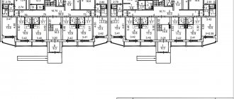
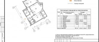
What is a territory plan
CBT consists of text and graphic information; it is a rather voluminous document containing more than 100 pages (up to 1000 pages). CBT information is divided into sections.
Let's consider what data is reflected in the territory plan.
Section 1:
- Cadastral numbers of all plots located in the block.
- Addresses of these sites.
- Land category and purpose.
- Square.
- Cadastral value.
Section 2:
- Cadastral numbers of capital construction projects located in this quarter.
- Their addresses.
- Purpose (residential building, apartment building, non-residential, unfinished construction).
Section 3:
Graphic part, schematic representation of land plots.
Section 4:
- Numerical values of plot coordinates.
- The accuracy of their determination (10 cm, 20 cm, 25 cm).
- Description of fixing the corners of the site on the ground.
Section 5:
- Coordinates of buildings and structures.
- The accuracy of their determination.
Section 6:
Description of the location of the block itself, in coordinates.
Section 7:
Zones with special conditions of use of the territory (ZOUIT) available in a given quarter (security zone of utilities, water protection zone, etc.)
- Description of each zone in coordinates.
- Method for determining coordinates and determination error.
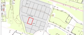
Example of a cadastral plan of a territory:
KPT information in the form of continuous text with numerical values of coordinates will not give the applicant a complete idea of the location of objects in the block and what areas a particular security zone passes through. The graphic representation of information from the CPT is fully reflected in the Public Cadastral Map, so let’s look at the graphic part of the CPT using the example of information from the Public Map.
The block 90:18:010147 is highlighted in yellow on the map, within which the areas for which land surveying has been carried out are shown, as well as buildings linked to the areas by specifying the location of the building on the ground. There are no special zones in the quarter under consideration. ZOUIT is marked in green, the nearest one passes through the neighboring block.
To find the desired area on the Public Map, you need to enter its number into the search bar, after selecting “blocks”, as shown in the figure.
In order to open the graphics of special zones, you need to click on the search (magnifying glass icon), select map management and check the ZOUIT box (see figure).
Documents and validity periods
Documents certified by electronic identifiers in the form of cadastre extracts will be valid until such time as a new facility is reconstructed or constructed on the territory.
This document does not have a validity period, but it will show the real situation for land surveying and development of a technical plan until a new property appears. After this, you need to make adjustments and update the data entered in the register.
It is advisable to make such changes on time or in parallel with the completion of construction work. This will allow you to protect ownership rights to the structure and have up-to-date technical and land documentation for a commercial or residential building.
Who needs and where is CBT information used?
Basically, KPT data is in demand by land specialists: they are used by administrative workers, cadastral engineers to prepare cadastral documentation, etc. An extract from the Unified State Register or KPT is the basis of any boundary or technical plan.
Engineers load electronic versions of the CPT into special programs that allow, for example, to form a new site in such a way that it does not cross the boundaries of existing sites, buildings, roads, boundaries of settlements, etc. Government employees, accordingly, use the information available in the Unified State Register of Real Estate to approval of schemes for CPT, entering new data into the register. As an alternative to the CPT, the owner can use the Public Cadastral Map, find the desired block, read available information about real estate, and identify locations for the possible formation of a site or annexation of unoccupied municipal territories.
Before ordering CBT, you need to make sure that its information will really be useful to you. Perhaps you will get all the necessary information using the Public Cadastral Map or Rosreestr reference information, which are publicly available and free. The above describes how you can use the map to obtain information from CBT.
The cadastral plan of the territory does not have a specific validity period. If new areas were formed in the quarter, boundaries were added to existing objects for which the location was not clarified, or boundaries of special zones appeared, then the previously ordered CPT will not contain up-to-date and complete information.