What is a site planning scheme
SPOZU (SPZU or planning organization scheme for site development) is an official document on the basis of which permission to develop a land plot is issued. It consists of a graphic diagram and an explanatory note, which contains the main technical parameters. The construction object (usually a house) is indicated by a drawing on the image of the site and is located within its boundaries. Also, the diagram must contain all the utilities that are included in the construction plan.
Full instructions for the preparation of SPROS and the regulatory framework are regulated by Decree of the Government of the Russian Federation N87, adopted in 2008.
SPOZU is required for different types of capital construction projects. They differ in purpose and methods of subsequent operation:
- industrial (including buildings for defense and security) without linear facilities;
- non-production (buildings related to housing, social, communal, household and cultural purposes), as well as other objects not used for production purposes;
- linear – objects that include wires, pipes, railways and other communications.
The diagram may be required for:
- the beginning of land development;
- for reconstruction, alteration or other additional construction work;
- to change a project that has already begun to be implemented, or has been partially built, for approval by the right city administration.
The full list of objects for the construction of which requires the preliminary preparation of a SOPSU is regulated by the Regulations on the composition of sections of project documentation and requirements for their content.
The diagram may be required for different construction projects
What is SPOSU and what does it include?
This document consists of 2 parts: graphic (actually, the diagram itself) and descriptive (more about it below). The following data must be indicated on the SPROM:
- The number of the GPZU issued to you.
- Plan of the house you intend to build.
- Capital structures already existing on the site. Please note: summer kitchens, greenhouses, sheds and even garages with bathhouses are not considered capital. objects - so, “temporary buildings”.
- Utilities laid along the site. If there are none yet, officials may become capricious and not issue a building permit. But this rarely happens, and the only way out of this situation is to file an application in court (or bribe, but this is more than unlawful and even criminal, don’t forget!).
- Passages and entrances to future and already built capitals. objects.
- If security, sanitary zones or zones of land easements run through the site (but this, in practice, does not apply to low-rise construction, but just in case), then their boundaries are indicated.
- Land area. By the way, if the courtyard is less than 1,200 m2, you can forget about the second floor.
- The area of all existing (and built in the near future) capital facilities on the site.
- Calculation of the development coefficient as a percentage (it is calculated as twice two: divide what you get in step 8 by the figure from step 7. And then multiply by 100).
- Type of fencing (mesh, wooden, reinforced concrete fence, etc.).
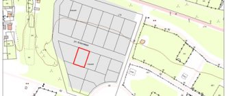
Scheme of planning organization of a land plot (SPOZU)
What are the requirements for SPOS in 2021?
The graphic part of the document is a schematic representation of construction objects drawn on paper. Both completed elements and those planned for construction are placed. The diagram also indicates the location of the main communications and roads to the facility.
The requirements for organizing the SPZU are identical to the regulations for the implementation of the urban planning plan. It is on the basis of the latter that a land plot diagram is drawn up and the subsequent location of capital construction projects is developed. The urban development plan of the territory is not developed by the land owner independently. It can be obtained from the local administration by first submitting such an application. The urban planning plan provides the following information:
- list of permitted purposes of the land plot;
- urban planning regulations;
- technical potential of the plot, availability and possibilities of its connection to capital engineering networks;
- the requirements that the construction project must comply with, as well as its permitted parameters and location;
- graphic drawing of the allotment.
From the moment the urban development plan is submitted by the administration, the document will be valid for 3 years, after which it will need to be requested again.
The permit is valid for 3 years, during this period it is advisable to complete the construction
Based on the above information, a planning organization scheme for the development of the site is formed. To facilitate the preparation of a graphic image (scheme), it is possible and recommended to take a current urban plan with a scale (1:500) or a topographic map of the land plot as a basis.
In order for the site development plan for a building permit to be accepted by the city authorities without refusal or modifications, it is worth adhering to the following recommendations for its preparation:
- the diagram must be applied to high-quality blank paper in A4 or A3 format;
- it is allowed to execute the drawing using computer programs or manually;
- If there is an error or correction, the image should be redone.
Only the final version of the SPOSU is confirmed. In some cases, minor corrections are acceptable, but only if they have been properly certified. This is done according to the following algorithm: an administration employee or authorized person makes edits, crossing out errors in the text, and writes down the correct information next to it. It is signed with the phrase “Believe the Corrected” and certified by the signature of the executor of the scheme - the owner of the site or his assistant.
If the scheme is completed correctly and complies with the urban planning plan, the SPOZU can be used to obtain permits for construction.
Subsequent documents can only be collected if the diagram is correctly drawn up
See also: Catalog of companies that specialize in designing country houses.
Requirements for the content of the text part
We should start with a description of the characteristics of the memory. Here you can indicate the construction address, cadastral number, neighboring objects (what it borders on). They add here information about the soil and climatic features - a detailed description of the site is given. The requirements for the layout of the planning organization of a land plot for the text section establish the following points as mandatory:
- About sanitary protection zones (if the landfill falls within them).
- Justification of the planning organization. Here you need to provide links to the city general plan, territory planning projects, GPZU and other official documents. It would not be amiss to mention GOSTs and SNiPs.
- Technical and economic indicators. Their composition depends on what exactly will be built on the land in question.
- Engineering training. It is necessary to justify the necessary measures (for example, transfer of communications).
- Description of the relief. Particular attention is paid to slopes.
- Improvement. This includes information about future driveways, playgrounds, landscaping, etc.
- Zoning of the territory (if necessary).
- Transport communications (if the facility is associated with production).
- Access to the site. Here they indicate which streets you can use to get to the future construction site. Particular attention is paid to the fire passage.
What should the scheme be?
The document for the planning organization of a land plot consists of two parts - the image itself and an explanatory text note. The graphic component contains the following information:
- determination of the boundaries of the land plot in strict accordance with cadastral registration and land surveying;
- designation of the contours and true dimensions of the object planned for construction, indicating its exact location and the absence of any additional internal notes;
- if certain buildings are already located on the site, they are also marked on the diagram;
- objects planned for demolition to organize new construction are indicated on the diagram with appropriate signatures;
- if according to the urban planning plan there are special zones located on the territory of the site, for example, the boundaries of security zones for various purposes, then they must be marked on the diagram;
- this part of the document also indicates possible areas of public easement1;
- at the end, it is necessary to graphically plot all utility networks, taking into account their throughput, as well as the places where they will connect to the construction site.
A public easement can become an obstacle to the construction of a house.
1 A public easement is a documented possibility of using part of a land plot for general (neighborhood) use. This may be necessary, for example, if there are no other ways to access another area and in other special cases.
Many land owners know in advance about the existence of a public easement on the territory of a land plot, since for its official installation it is necessary:
- a legally binding agreement between the actual owner of the site and the second party who needs to register this encumbrance;
- notarized;
- is entered into Rosreestr.
A public easement is an extreme form of solving a problem situation, and is used only if no other solution can be found. Most often, public easement zones are given this status due to the location of important communications of urban importance (water or gas pipelines) on them. Unlike the private form of special purpose land, no monetary compensation is provided to its owner for the use of the land.
Samples of planning development/reconstruction schemes
The price of drawing up a planning scheme for organizing a land plot
SPOSU is not a strict document that you can sketch with your own hands. And it will cost you absolutely nothing (If you do it yourself). Moreover, you can download for free the latest version of the program Our Garden Rubin 9.0, which will definitely help you do without the help of money-grabbing architectural firms.
But if you don’t believe in your own capabilities and are afraid to make a diagram yourself, then Google it on the Internet or find out in the architectural department who makes the SPOZU. And, by the way, don’t forget to find out what the price of a planning scheme for organizing a land plot is in those architectural offices where the friendly servants of the local municipality will send you.
The range of prices for drawing up a diagram is impressive: from 5 to 20 (or more) thousand, almost full Russian rubles. Therefore, if you didn’t find the treasure the day before yesterday, weigh it three times, but is it really necessary to order a simple, in general, SPOSU scheme? Next, carefully read the rules that must be followed when drawing up this scheme.
DIY SPOZU
In order to draw up a SPOSU, it is not necessary to contact specialists. You can do it yourself by repeating it according to a sample from the Internet. However, it should be understood that even if the model scheme is similar to the site in real life, you will still have to spend enough time and effort to adapt it and meet all the requirements of the administration.
You can make the SPOZU yourself, but you will have to tinker with adjusting it to the requirements