Coordinates are understood as a system of points that determine the position of an object on a plane. Accordingly, the coordinates of the building will determine its position on the land plot on which the object is located. In the presented material you can learn the features of determining the coordinates of buildings and structures, as well as the procedure for transferring them into technical documentation for real estate objects.
Get an estimate of the cost of this service using our price calculator - here
Read in the article what the coordinates of a building are, how they are determined, who coordinates for Rosreestr, where you can request information.
Determining the coordinates of buildings and structures in 2021
In accordance with Art. 14 of Federal Law No. 218 of July 13, 2015, one of the grounds for carrying out the procedure for cadastral registration and registration of real estate is the submission of a technical plan. This document contains basic information about the following objects:
- building;
- construction;
- premises;
- parking space;
- unfinished construction project;
- single real estate complex.
General requirements for the content and procedure for drawing up the technical plan are regulated by Art. 24 of Federal Law No. 218-FZ. Clause 4 of Art. 24 of Law No. 218-FZ indicates that the graphic part of the plan must indicate the location of a building or structure on a plot of land. It is to describe such a location that the coordinates of the property are needed.
Dear Clients!
The information in this article contains general information, but each case is unique. You can get a free consultation from our engineers using one of our telephone numbers - call:
8 Moscow (our address)
8 St. Petersburg (our address)
All consultations are free.
To fix the coordinates of a building and structure, it is necessary to determine the coordinates of the characteristic points of the contour of these objects. Since characteristic points are understood as places where the direction of straight lines changes, for a building such points will be any changes in the contour of the object - corners, convexities, etc.
To determine the coordinates, cadastral work is carried out. The coordinates will be described in a technical or boundary plan.
In addition to transferring the coordinates of the characteristic points of the object, the technical plan may include a spatial description of all or individual structural elements of the building. For this, additional description parameters are used, including taking into account the height or depth of individual elements.
Obtaining coordinates is carried out taking into account the following features:
- it is necessary to carry out cadastral work in relation to the land plot and the object located on it;
- the work is entrusted to a professional specialist - a cadastral engineer who has a qualification certificate;
- the establishment of the coordinates of a building and structure occurs as a result of the engineer’s use of methods provided for by regulatory legal acts, with standard accuracy indicators;
- the results of determining the coordinates are transferred by the cadastral engineer to the technical plan of the property.
Based on the technical plan, a cadastral registration procedure will be carried out in relation to newly constructed buildings and structures, after which the object is assigned a cadastral number, and information about it is entered into the Unified State Register of Real Estate.
Requirements for acceptable methods and standard accuracy of determining the coordinates of a building and structure are regulated in Order of the Ministry of Economic Development of the Russian Federation dated March 1, 2016 No. 90.
Expert advice . The preparation of a technical plan is carried out by a cadastral engineer on the basis of a contract with the customer - the owner of the building. Since, according to the norms of Federal Law No. 218-FZ, the technical plan is drawn up in the form of an electronic document, the customer must specifically stipulate the possibility of issuing the plan in writing. To do this, indicate such a condition in the text of the contract when concluding it. Such amendments are always included in the agreement with Smart Way LLC.
The infographic presents the main regulations for coordinating real estate objects.
Determining the coordinates of boundary markers
Geodetic work during land surveying
.
The main spatial unit of the cadastre of a real estate property is the land plot. A land plot means a part of the earth's surface (including the surface soil layer), the boundaries of which are described and certified in the prescribed manner by an authorized state body, as well as everything that is above and below the surface of the land plot, unless otherwise provided by federal subsoil laws, on the use of airspace and other federal laws.
Land surveying is a set of works to establish and restore the boundaries of the land plot on the ground and secure the turning points of the plot with boundary markers, determine the flat rectangular coordinates of boundary markers and the area of the plot.
Land surveying includes a number of works, the content of which is discussed below.
Preparatory work
These works include the collection and (or) study of information from the state real estate cadastre about the land plot (plots); documents certifying rights to land (in their absence - title documents); catalogs (lists) of coordinates of points of the reference boundary network and other initial geodetic points; addresses of persons whose rights may be affected during land surveying. At this stage, a project is drawn up for dividing the land plot into separate parts. Inspection of a land management facility includes identifying the condition of boundary signs and points of the geodetic network.
Drawing up a technical project
The text part reflects:
— the basis and purpose of the work;
— information about the points of the reference boundary network and other geodetic basis;
— information about previously completed land surveying work;
— organization, order of production and mathematical processing
geodetic or photogrammetric measurements;
— organization and timing of land surveying of a land management facility.
The alignment drawing is drawn up in a scale convenient for work, displaying the existing and design boundaries of the land plot, the position of boundary markers, points of the supporting boundary network and other geodetic basis, reliably identifiable contour points, angular and linear data for geodetic measurements, cadastral numbers. On the breakdown drawing, all design elements are shown in red.
Notification of persons whose rights may be affected during land surveying
Individuals and legal entities whose rights may be affected during land surveying (owners of land plots, landowners, land users and tenants of land plots, relevant government bodies and (or) local governments) are notified no later than 7 calendar days before the start of work about the time and place of the survey.
Determination of the boundaries of a land management object on the ground, their coordination and securing with boundary signs
Determination of the boundaries of a land management object on the ground and their approval are carried out in the presence of persons whose rights may be affected during land surveying, or persons authorized by them.
Before the procedure for approving the boundaries of a land management facility, they are preliminarily marked on the ground. The results of boundary approval are documented in an act(s) of approval of the boundaries of a land management facility, which is signed by all participants in the boundary approval procedure, including the work contractor.
The agreed boundaries of the land management object are fixed with boundary signs that record on the ground the location of the turning points of the boundaries of the land management object.
The types of boundary signs and the procedure for their installation (laying) are approved by the Order of the Ministry of Economic Development of Russia.
The cadastre is maintained in local coordinate systems, the rules for establishing which are approved by the Decree of the Government of the Russian Federation. A local coordinate system is understood as a conditional coordinate system established in relation to a limited territory not exceeding the territory of a constituent entity of the Russian Federation, the origin of coordinates and the orientation of the coordinate axes of which are shifted relative to the origin of coordinates and the orientation of the coordinate axes of the unified state coordinate system used in the implementation of geodetic and cartographic works.
A mandatory requirement when establishing local coordinate systems is to ensure the possibility of transition from the local coordinate system to the state coordinate system, which is carried out using transition parameters (keys). The geodetic basis for land surveying is the points of the state geodetic network and the points of the reference boundary network of two classes of compulsory medical insurance 1 and compulsory medical insurance 2. Basic boundary networks are created in all cases when the accuracy and density of state, city and other networks does not correspond to the specified basic provisions.
To determine the flat rectangular coordinates of boundary markers, satellite geodetic definitions are used; geodetic methods (triangulation, polygonometry, triangulation, serifs); photogrammetric methods; technologies based on the use of airborne and ground-based laser scanning; cartometric methods.
Determination of land area
The area of a land plot is most often calculated using the coordinates of the turning points of its boundaries.
Drawing up a boundary plan
A boundary plan is a document that is drawn up on the basis of a cadastral plan of the relevant territory or a cadastral extract about the corresponding land plot and in which certain information included in the state real estate cadastre is reproduced and information about the land plot or land plots being formed, or about part or parts of the land plot is indicated , or new information about the land plot or land plots necessary for entering into the state real estate cadastre.
The boundary plan consists of graphic and text parts.
The graphic part of the boundary plan reproduces information from the cadastral plan of the corresponding territory or cadastral extract about the corresponding land plot, and also indicates the location of the boundaries of the land plot or land plots being formed, or the boundaries of a part or parts of the land plot, or the specified boundaries of land plots, access to the formed land plots (passage or passage from public land plots), including by establishing an easement. The graphic part of the boundary plan includes a diagram of geodetic constructions, a diagram of the location of land plots and their parts, drawings of land plots and their parts, outlines of nodal points of the boundaries of land plots.
The text part of the boundary plan indicates the information on the land plot or land plots necessary for entering into the state real estate cadastre, information on the approval of the location of the boundaries of the land plots in the form of an act of approval of the location of such boundaries.
Accuracy of coordinate determination
Federal Law No. 218-FZ () includes among the basic principles of maintaining the Unified State Register of Real Estate the completeness and reliability of information about each property that has undergone the cadastral registration procedure. For this reason, the implementation of these principles depends on the accuracy of the description of the boundaries of land plots and buildings on it.
For this purpose, Order of the Ministry of Economic Development No. 90 () was adopted, which regulates the requirements for accuracy and methods for determining the coordinates of characteristic points of the contour of a building and structure. This regulatory document is subject to practical use by the cadastral engineer, who is entrusted with the description of the object when preparing the technical plan.
| No. | The procedure for determining the error for different coordination methods | Description |
| 1 | Geodetic methods | Calculation of the mean square error of the location of characteristic points is carried out using software through which field materials are processed, in accordance with the methods used |
| 2 | Satellite geodetic measurement method | Calculation of the mean square error of the location of characteristic points is carried out using software that processes satellite observation materials |
| 3 | Photogrammetric method | The value of the root-mean-square error in the location of characteristic points is assumed to be equal to 0.0005 meters on the scale of an aerial photograph (space photograph) reduced to the scale of the corresponding cartographic basis |
| 4 | Cartometric method | When determining the location of characteristic points shown on the map (plan), the value of the mean square error is taken equal to 0.0005 meters on the scale of the map (plan) |
If a new survey occurs, does the old coordinate system remain?
Hello. If a new survey occurs, does the old coordinate system remain?
Lawyer Antonov A.P.
Good afternoon
According to Art. 22 of the Federal Law “On State Registration of Real Estate”, a boundary plan is a document that is drawn up on the basis of a cadastral plan of the relevant territory or an extract from the Unified State Register of Real Estate about the relevant land plot and in which certain information entered in the Unified State Register of Real Estate is reproduced, and information about the land plot or land plots being formed, or about a part or parts of the land plot, or new information about the land plot or land plots necessary for entering into the Unified State Register of Real Estate is indicated. The boundary plan shall indicate: 1) information about the land plot or land plots being formed in the case of cadastral work, which results in the preparation of documents for submission to the rights registration authority of an application for state cadastral registration of the land plot or land plots; 2) information about a part or parts of a land plot in the case of cadastral work, which results in the preparation of documents for submission to the registration authority of rights of an application for state cadastral registration of a part or parts of a land plot; 3) new information about a land plot or land plots necessary for entering into the Unified State Register of Real Estate in the case of cadastral work, which results in the preparation of documents for submission to the rights registration authority of an application for state cadastral registration of a land plot or land plots. If, in accordance with federal law, the location of the boundaries of land plots is subject to mandatory approval, the boundary plan must contain information about such approval. The boundary plan consists of graphic and text parts. The graphic part of the boundary plan reproduces information from the cadastral plan of the corresponding territory or an extract from the Unified State Register of Real Estate about the corresponding land plot, and also indicates the location of the boundaries of the land plot or land plots being formed, or the boundaries of a part or parts of the land plot, or the specified boundaries of land plots, access to newly formed or modified land plots (passage or passage from public land plots), including through the establishment of an easement. The text part of the boundary plan indicates the information about the land plot or land plots necessary for entering into the Unified State Register of Real Estate, including information about the geodetic basis used in preparing the boundary plan, including points of state geodetic networks or reference boundary networks, as well as in the established Part 3 of this article in the case of information on the approval of the location of the boundaries of land plots in the form of an act of agreement on the location of such boundaries. The location of the boundaries of the land plot is established by determining the coordinates of the characteristic points of such boundaries, that is, the points of change in the description of the boundaries of the land plot and dividing them into parts. The area of a land plot, determined taking into account the requirements established in accordance with this Federal Law, is the area of a geometric figure formed by the projection of the boundaries of the land plot onto a horizontal plane. When clarifying the boundaries of a land plot, their location is determined based on the information contained in the document confirming the right to the land plot, or in the absence of such a document, based on the information contained in the documents that determined the location of the boundaries of the land plot when it was formed. If there is no information in the documents about the location of the boundaries of a land plot, its boundaries are considered to be boundaries that have existed on the ground for fifteen years or more and are fixed using natural objects or objects of artificial origin that make it possible to determine the location of the boundaries of the land plot. The boundaries of a land plot should not cross the boundaries of a municipal entity, except if an error reproduced in the Unified State Register of Real Estate is identified in determining the location of the boundaries of such a municipal entity in the document on the basis of which information was entered into the Unified State Register of Real Estate. The boundaries of the land plot should also not cross the boundaries of a populated area, except if an error reproduced in the Unified State Register of Real Estate is identified in determining the location of the boundaries of such a populated area in the document on the basis of which information was entered into the Unified State Register of Real Estate. The boundaries of the land plot should also not cross the boundaries of territorial zones, forestries, except in the case of the formation of a land plot for carrying out work on geological exploration of the subsoil, development of mineral deposits, placement of linear objects, hydraulic structures, as well as placement of reservoirs and other artificial water bodies, in the case , provided for in Article 60.2 of this Federal Law, or the case of identifying an error reproduced in the Unified State Register of Real Estate in determining the location of the boundaries of the territorial zone. At the same time, the intersection of the boundaries of a land plot with the boundaries of municipalities, settlements, territorial zones, forest districts, forest parks means: 1) the presence of a common point or points of the boundaries of the land plot and the boundaries of a municipal formation, settlement, territorial zone, forest district, which are formed as a result the location of one or more characteristic points of the boundaries of a land plot outside the range of the mean square error in determining the characteristic points of the boundaries of a municipality, settlement, territorial zone, forestry, forest park; 2) the location of at least one of the contours of the boundaries of a multi-contour land plot outside the boundaries of the corresponding municipality and (or) settlement or territorial zone. The boundary plan is prepared in the form of an electronic document and signed with an enhanced qualified electronic signature of the cadastral engineer who prepared such a plan. The boundary plan, if provided for in the contract, is also prepared in the form of a paper document, certified by the signature and seal of the cadastral engineer who prepared such a plan, for transfer to the customer under the contract. The form and composition of information on the boundary plan, requirements for its preparation, as well as requirements for accuracy and methods for determining the coordinates of characteristic points of the boundaries of a land plot are established by the regulatory authority. Thus, the coordinate system on the ground does not change when boundaries are marked.
Sincerely, lawyer Anatoly Antonov, managing partner of the law firm Antonov and Partners.
Still have questions for your lawyer? Ask them right now here, or call us by phone in Moscow +7 (499) 288-34-32 or in Samara +7 (846) 212-99-71 (24 hours a day), or come to our office for a consultation (by pre-registration)!
Who can coordinate buildings?
The determination of the coordinates of buildings is carried out by a cadastral engineer during cadastral work. The specified specialist is responsible for the accuracy of measurements and the correct choice of research methods.
The procedure for the owner of an object who needs to obtain a technical plan with certain coordinates is as follows:
- selection of a cadastral engineer who has a qualification certificate and is a member of one of the specialized self-regulatory organizations;
- submission of documents confirming the legality of ownership of the site and the constructed facility: land lease agreement, construction permit;
- concluding a contract with defining the list of assigned works.
The final measurement result will be formed in the form of a technical plan, which the cadastral engineer is obliged to send to the cadastral registration authorities in electronic form. To do this, the engineer certifies the technical documentation with a personal electronic digital signature and sends it to the cadastral chamber of Rosreestr via electronic communication channels.
To determine coordinates, a geodetic network and corresponding points are used.
Surveyor and his work
Geodetic activities include topographic-geodetic, survey, design and a number of other types of work. It is the data from geodetic measurement methods that the cadastral engineer will use when performing work on real estate.
The rules for conducting geodetic work are determined by Federal Law No. 431-FZ. A surveyor is a professional specialist with a specialized higher technical education, responsible for the accuracy of any type of work on the construction of buildings and structures.
How to find out the coordinates of a building in 2021
The coordinates of buildings and structures determined by cadastral engineers will be formed in the form of a technical plan. After sending the specified document to the Rosreestr authorities, the data is transferred to the Unified State Register of Real Estate. It is the information from the Unified State Register of Real Estate that will be a complete and reliable source of data on all parameters of the property. including coordinates.
Based on the norms of Federal Law No. 218-FZ, the official sources of coordinates for a property are:
- USRN extract;
- map-plan of the territory.
Since the Unified State Register is maintained on the principles of openness and public availability of information, any interested person can obtain these documents by contacting the territorial office of Rosreestr or the Multifunctional Center, as well as using the electronic portal of state services.
Expert commentary . Please note that starting from January 2021, a cadastral passport for real estate is no longer issued; the information in this document is included in the Unified State Register of Real Estate (USRN) extract.
Extract from the Unified State Register of Real Estate
Starting from July 2021, not a certificate of title, but an extract from the register is issued as confirmation of the emergence and transfer of rights to real estate. With the entry into force of Federal Law No. 218-FZ, the Unified State Register is replaced by the Unified State Register, and it is from this register that information will be provided to interested parties.
When making a transaction or registering a new object, an extract of the Unified State Register is issued to the copyright holder free of charge. With each subsequent application for an extract, the applicant will have to pay a state fee. According to Order of the Ministry of Economic Development of the Russian Federation No. 975, the contents of the extract consists of the following subsections:
- subsection I – information about the property (technical characteristics, area, cadastral number, etc.);
- subsection II – information about the copyright holder, as well as the date and grounds for the emergence of rights;
- subsection III – information about registered encumbrances on the object.
The legislation does not establish restrictions on the number of USRN extracts; any interested person can submit a request an unlimited number of times.
Expert advice . The owner of the property has the right to receive an extended extract from the Unified State Register of Real Estate. In addition to the standard list of information, the extended extract will contain information about all transactions with the object that have been completed since the moment it was registered in the cadastral register.
The EGRN extract also contains data on the coordinates of the building. Rosreestr enters information into the Unified State Register of Real Estate on the basis of the technical plan.
CBT
The content and purpose of the territory plan map are defined in Article 24.1 of Federal Law No. 218-FZ. This document is formed based on the results of complex cadastral works (CCW) and includes:
- an explanatory note indicating the grounds for conducting QCR;
- information about real estate objects that were the subject of the QCR;
- the act of agreeing on the boundaries of a plot of land during the implementation of the land survey;
- conclusion of the conciliation commission based on the results of consideration of objections regarding the boundaries of the plots.
Interested parties can obtain an extract from the KPT by contacting the Rosreestr authorities. This extract, among other information, will contain a description of the location of the real estate objects.
Expert commentary . It is possible to obtain an extract from the CPT both on paper and in electronic form. Regardless of the form of extracts from the CPT, they will have equal legal force.
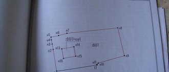
An example of a copy from a map-plan of a territory that is used in urban planning.
How to determine the boundaries of a land plot?
There are several ways to establish actual boundaries by law:
- In fact. This provision applies if the site has not been demarcated. In this case, you will need to order a land surveying service to clarify the boundaries. When there are no disputes with neighbors, boundaries are determined quickly. They are established according to boundary signs, after which the owners of adjacent plots sign an act of approval of boundaries. Historically defined points can be used as boundary markers. For example, a fence has been built between the plots, and the neighbors do not make claims against each other. In this case, the cadastral engineer will establish a boundary along the fence.
- According to cadastral information in Rosreestr. This method of establishing boundaries is applicable in cases where land surveying has been carried out, but in fact there are no demarcation signs between the areas. In this case, what is required is not so much the establishment of boundaries as the actualization of them. The information specified in the cadastre is taken as a basis. Based on these data, boundary markers are established.
In theory, the procedure for setting boundaries is very simple, but in practice many difficulties arise. Most often, problems arise at the stage of agreeing on established boundaries. They can be caused by various reasons:
- The neighbors disagree. When establishing de facto boundaries, neighbors often express disagreement. This is especially common in cases where, even before the boundaries were established, there was a dispute over the land between the owners of adjacent plots.
- It is impossible to find neighbors. The neighboring plot has long been abandoned, and you don’t know who owns it. Previously, this situation was almost insoluble. Now the law establishes regulations that make it possible to establish a border even in this case. However, you need to be prepared for the fact that in complex cases this will require additional time.
- During the establishment of boundaries, cadastral errors were discovered. Another common problem that arises when establishing actual boundaries. The cadastral engineer sets the boundaries, begins to overlay them on the cadastral map and detects errors. Correcting such errors affects the interests of not only the owners of adjacent memory; sometimes many more interested parties are involved in the dispute. For example, when surveying one of the sections, an error was made, and the boundaries of the following sections were established in relation to erroneous data. In such cases, it is difficult to give one universal advice. Each situation is individual, and the decision must be made taking into account specific data.
Geographic coordinates via Google maps
The development of electronic geolocation services makes it possible to determine the location of an object by its coordinates. The Google service allows you to search for places by geographic coordinates, as well as determine the coordinates of already known points. The procedure for working with this information can be clarified in the instructions at:
https://support.google.com/maps/answer/18539?co=GENIE.Platform%3DDesktop&hl=ru .
In addition, this electronic resource allows you to work with a visual graphics card. When you select a property of interest on this map, its characteristics, including geographic coordinates, will be displayed.
Expert commentary . Despite the development of technology, the Google map service is not an official source of information on the coordinates of objects; it can only be used as reference data. To obtain objective and reliable information, you must obtain an extract from the Unified State Register of Real Estate.
Coordinate
A coordinate is a point indicating the territorial location of someone or something in space. Modern science uses letters and numbers to illustrate an object on a plane.
Since the notation system is used in most of the exact sciences, accordingly the meanings in various sciences remain unchanged for ease of understanding. The notation system was invented by scientists to solve most practical and theoretical problems.
The coordinate system was created a long time ago, hundreds of years ago. But it acquired a modern, scientific look only recently. As mentioned earlier, the coordinate system is used by most modern sciences. However, in geodesy, coordinates play an almost dominant role. This is because all the work of a surveyor begins with the designation of locations by a group of coordinates.
Location used in:
- Mathematics, geometry (for constructing graphs and functions).
- Artillery.
- Cartography (to indicate objects on the map).
- Astronautics.
- Aeronautics.
- Shipping, as well as abstract and exact sciences.
Thus, you can clearly see that the specifics of using coordinate notation are diverse.
Determination of coordinates, as a rule, is carried out only on two axes of space. The ability to determine the most accurate location of an object requires the inclusion of a third axis - heights. An object is defined not in a plane, but in space.
List of useful documents
Documents for download:
Get an estimate of the cost of this service using our price calculator - here
| No. | Links | Description |
| 1 | Sample technical specifications for construction, reconstruction | |
| 2 | Sample application for a permit to construct a new building | |
| 3 | Sample technical plan for registering a building | |
| 4 | Sample application for cadastral registration | |
| 5 | Sample USRN extract | |
| 6 | Sample application for a commissioning permit | |
| 7 | Sample application for project examination | |
| 8 | Recommendations for preparing design documentation for examination |
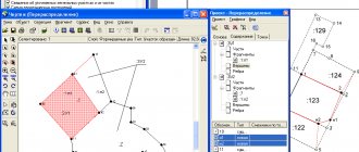
What do corner coordinate points look like?
The coordinate system of a property includes corner points at which the direction of straight lines changes. For a standard object in the shape of a rectangle, four corner coordinate points will be defined, but in practice, dozens of corner points can be installed for any building and structure.
A typical example of defining corner coordinate points can be seen in the following diagram (the specified object contains 28 corner coordinate points).
Coordinates of the building in 2021. Questions to the expert
Konstantin M.
Expert in the field of certification, cadastre, real estate and design. Higher legal education, more than 10 years of work experience.
Ask a Question
Question to the expert
Can we independently determine the coordinates of a private house and indicate them in the declaration for Rosreestr?
No, this procedure does not apply from 2021. Now only the cadastral engineer coordinates all real estate objects.
How will Rosreestr find out about the coordinates of our building if we have just put it into operation?
For this purpose, after putting the facility into operation, you need to order a technical plan. In it, the cadastral engineer will indicate the coordinates and characteristics of the building for Rosreestr.
If during cadastral work an error was made in the coordinates of the building, how to correct it?
Technical or registry errors, including those regarding object coordinates, are corrected by a cadastral engineer. Usually for this purpose repeated cadastral works are carried out.
Hello! If we need to know the exact coordinates of our warehouse, where can we get such information?
This data can be obtained from Rosreestr. The EGRN extract indicates not only the technical characteristics of the building, but also its coordinates.
Are previously established coordinates of the land plot irrelevant?
Evelina Balybina, head of the document processing and accounting operations department No. 1, helped to understand this issue. She explained that if state cadastral registration has been carried out in relation to a land plot and information about it has not been excluded from the Unified State Register of Real Estate, then all information about this land plot, regardless of changes in legislation, is considered valid, and, accordingly, the coordinates of characteristic border points, even if they are set in a conventional coordinate system.
But at the same time, there are still a number of reasons that are really worth thinking about when deciding whether it is worth recalculating the coordinates of a land plot from a conventional coordinate system to the MSK-68 coordinate system and why this is necessary.
First of all, the conditional coordinate system does not imply fixing the boundaries on the terrain of the land plot relative to other areas, points of state geodetic networks and reference boundary networks. Accordingly, the location of the site is set virtually.
Secondly, land plots whose boundaries are established in accordance with current legislation, namely in the unified MSK-68 coordinate system established throughout the Tambov region, are displayed on the public cadastral map, which eliminates the question of when a person turns to and asks us: I own a plot of land, but it is not on the public map. Why? With the establishment of site boundaries from a conventional coordinate system in MSK-68, this problem disappears. In this case, no one will be able to violate your borders, and the boundaries of neighboring land plots will already be established along your borders, that is, any intersections or overlaps of boundaries are excluded, which subsequently, as a rule, in connection with the emergence of a land dispute, are resolved in court .
Also, when purchasing a land plot whose boundaries are not established, you run the risk of buying a land plot only on paper, but in fact it may be located in a completely different place that does not correspond to your desire.
So, let's sum it up. If you have decided for yourself that you want to establish the boundaries of your land plot in the unified coordinate system MSK-68, where should you start. First of all, you need to contact a cadastral engineer, information about whom is contained in the register of self-regulatory organizations, that is, the person who has the right to engage in cadastral activities. The cadastral engineer will prepare a Land Survey Plan for you in electronic form, that is, on disk. With the disk, you already apply to any Multifunctional service center with an application for state cadastral registration of changes to the land plot in connection with clarifying the location of the boundaries. After cadastral registration, you will be able to see information about the boundaries of your land plot on the public cadastral map.
Coordination of land plots
Determination of the coordinates of land plots is carried out according to similar principles established by Order of the Ministry of Economic Development No. 90. However, when establishing characteristic border points, the following features must be taken into account:
- when determining the coordinates and boundaries of a site, it is necessary to take into account data on the boundaries of adjacent sites;
- in order to include information about coordinates in the boundary plan, it is necessary to draw up an act of coordination of boundaries with all owners of adjacent objects;
- the result of cadastral work on the site is formed by the cadastral engineer in the form of a boundary plan.
Until January 2021, information about the coordinates of the site was contained in the cadastral passport. With the adoption of Federal Law No. 218-FZ, an extract from the Unified State Register of Real Estate is used instead of a cadastral passport.
Expert advice . If a dispute arises about the boundaries of the site, an agreement is drawn up. If, as a result of the approval, the owners of the plots were unable to reach an agreement, the dispute is referred to the judicial authorities.
According to the technical plan, the location of the object on the site is determined.
What to do if the building is previously registered and does not have coordinates?
If, as a result of cadastral registration in the Unified State Register of Real Estate, certain information about the property is missing, this is a data error. The reasons for the error can be both technical violations when transferring data to the Unified State Register of Real Estate, and violations during cadastral work or the formation of a boundary and technical plan.
Correction of errors is carried out by contacting the Rosreestr authorities with a corresponding application. The opportunity to apply to correct an error is provided to the copyright holders of the objects; for this, the application must indicate the grounds for establishing violations in the information.
Legal and actual boundaries of the land plot
The boundaries and area of a land plot are two of its important characteristics. In essence, the border is a kind of conditional line connecting two turning points.
Let's imagine an ordinary quadrangular plot. It has 4 turning points in each corner. The line between them will be the border. For multi-circuit areas there will be more such points.
During cadastral work, a specialist will determine the coordinates of turning points, and only then connect them with lines on the plan. These lines will be the boundaries. The accuracy of the boundaries will depend on how accurately the coordinates of the turning points are set. When registering land for cadastral registration, it is not the lengths of the boundaries that are indicated, as it might seem, but the coordinates of characteristic points. Only in this way can the location of the site be unambiguously determined, eliminating the possibility of discrepancies.
To establish the boundaries of a land plot, a land surveying procedure is carried out. However, it is possible to say that boundaries have been established in relation to your land plot only after the necessary data has been entered into the Cadastre. Finding out whether there was a land survey is very simple. Look at the cadastral extract for the characteristics of your site. If boundaries have been established, all data will be indicated in this document.
Establishing boundaries, first of all, is necessary for the owner of the site, since it allows protecting the rights of the owner. Despite this, even with land surveying carried out, you can find yourself involved in a boundary dispute with your neighbors. This has several reasons. Firstly, when determining the coordinates of turning points, there is an error allowed by law. Secondly, these points may look different on the ground. As a result, it is not uncommon to encounter situations where the actual boundary runs inside a previously constructed building. Even more often, actual boundaries run along fences, walls of buildings, and can be represented by pegs.
In order for the actual border to be established in accordance with the law, it must correspond to the data from the cadastre. That is, if your fence between two properties follows the line between the turning points, everything is legal.
Where can I order building coordination?
To order building coordinates, prepare a technical plan, or make changes to cadastral registration, please contact ]Smart Way[/anchor]. We have extensive experience, allowing us to work with objects of any complexity.
You can find out more about our services by phone or through the feedback form. The table below shows prices for some types of services and work.
| No. | Service, document | Price |
| 1 | Construction design | from 30,000 rub. (depending on the area and features of the building) |
| 2 | Support of the commissioning procedure | from 25,000 rub. (depending on the area and features of the object |
| 3 | Preparation of a technical plan | from 8000 rub. |
| 4 | Support of the cadastral registration procedure in Rosreestr or MFC | from 12,000 rub. |
| 5 | Facilities coordination | from 30,000 rub. |