On the need to clarify the boundaries of previously registered land plots
| Shafeeva E.I., assistant, Imamgayazova V.M., 4th year student Bashkir State Agrarian University, Russia |
The importance of eliminating “white spots in the cadastre” is considered - in the form of land plots without established boundaries, the number of which, at the current level of development of the cadastral sphere, should gradually be reduced to zero.
As you know, the state real estate cadastre contains information about land plots that have the status of “previously registered”. These are land plots, the state cadastral registration of which was carried out before the entry into force of the cadastre law, and land plots, the state cadastral registration of which was not carried out, but the rights to which have been registered and have not been terminated.
Information about previously registered land plots, with the adoption of the Federal Law “On the State Property Committee”, was entered into the state real estate cadastre - on the basis of inventory records, that is, the boundaries of the plots were never established in accordance with the current legislation and do not have established coordinates. Also, information about previously registered land plots was entered into the database of the state real estate cadastre to the extent that was contained in the title document for the land plot.
If a given land plot has not passed the procedure for establishing boundaries and area, it means that it is recorded in the state real estate cadastre without the coordinates of the turning points of the boundaries or they are indicated approximately.
The consequences of the presence in the state real estate cadastre of inaccurate information about the boundaries of a land plot can be very different - from the involuntary seizure of part of an adjacent land plot to the discrepancy between the actual area on the ground and that indicated in the documents of the unified state register of rights. Taking into account the likelihood of inaccurate determination of boundaries, and as a result, determination of the area of a land plot with an error, it is impossible not to note the likelihood of an unfair calculation of the amount of payments for the use of land plots.
To enter information about the boundaries of a previously registered land plot, cadastral work must be carried out in relation to it.
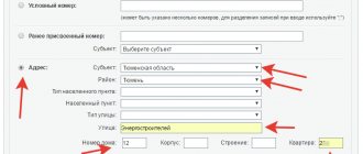
When clarifying the boundaries of a land plot, their location must be determined based on the information contained in the document confirming the right to the land plot, or in the absence of such a document, from the information contained in the documents that determined the location of the boundaries of the land plot when it was formed. If the specified documents are missing, the boundaries of the land plot are the boundaries that have existed on the ground for fifteen years or more and are fixed using natural objects or objects of artificial origin that make it possible to determine the location of the boundaries of the land plot. [1]
Clarification of the location of the boundaries of previously registered land plots is carried out in the following cases:
- in the absence of information in the state real estate cadastre about the specific coordinates of the characteristic points of the boundaries of the land plot, its graphic description;
- if the coordinates of the characteristic points of the boundaries of the land plot contained in the state real estate cadastre are determined with an accuracy lower than the standard accuracy of determining the coordinates for lands of a certain purpose.
The cadastral registration authority may decide to suspend cadastral registration if one of the boundaries of the land plot for which an application has been submitted for cadastral registration, when entering information on the duty cadastral map, crosses one of the boundaries of another land plot, information about which is already contained in the state cadastre real estate, as well as for other reasons specified in Art. 26 Federal Law No. 221 “On the State Committee for Taxation”. Also, the law provides that during cadastral registration in connection with clarification of the boundaries of a land plot, the cadastral registration authority may decide to refuse to carry out registration if, as a result of cadastral registration, the area of the land plot, determined taking into account those established in accordance with Federal Law No. 221 “On GKN" dated July 24, 2007 requirements, there will be more than the area, information about which regarding this site is contained in the cadastre, by an amount greater than the maximum minimum size of a land plot established in accordance with land legislation for lands of a certain purpose and permitted use, or , if such a size is not established, by an amount of more than ten percent of the area, information about which regarding a given land plot is contained in the cadastre.
When maintaining the state real estate cadastre, one of the most important problems is the presence in the State Property Committee of information on land plots with uncertain boundaries. To resolve this issue affecting the entire country, a massive clarification of the boundaries and areas of land plots has been organized. [2] Unfortunately, there are still enough such land plots on the territory of our country. Taking into account the declarative nature of cadastral registration, their owners may not even suspect that there is no information about the coordinates of their land plot in the cadastre.
At the beginning of 2015, Federal Law No. 221 “On the State Real Estate Cadastre” included the chapter “Complex cadastral works”. Complex cadastral work will be carried out simultaneously in relation to all land plots and capital construction projects with registered rights to them, located in the territory of one cadastral quarter or the territories of several adjacent cadastral quarters. Thus, land plots whose cadastral information does not meet the established requirements for describing the location of the boundaries of land plots will be identified and information about them will soon meet the requirements of all existing norms of modern legislation.
What it is?
Clarifying the contour of the plot consists of documenting deviations of the received data from those contained in the previously drawn up boundary plan.
In fact, changing boundaries may involve the following actions:
- Changing the configuration of the contour line defining the area of land while maintaining the value of the original area. In such a situation, when entering data, part of the area in a certain place of the formed figure decreases, in another it increases, and in general the value remains identical to that indicated in the cadastral passport. In parallel with this lack of a procedure for affecting the value of the area may mean that in fact the area remains the same, and only the data in the boundary plan will change, which for a number of reasons contains erroneous information;
- Changing the boundary while simultaneously clarifying the values of its area. In such a situation, existing cadastral registration errors can be corrected or boundary changes can be made directly on the ground while simultaneously adding ownerless territory as an “addition” to the extent permitted by the Land Code.
The meaning of the inscription “Without border coordinates”
To ensure normal exploitation of land , conservation of its subsoil, legal allocation of land plots (PL) and receipt by the state of taxes for the use of land, cadastral registration has been introduced in the Russian Federation.
Registration of land plots is carried out using the real estate register (USRN), which since 2015 (Law 218-FZ) has combined the previously existing real estate cadastre (GKN) and the register of rights (USRE).
The Unified State Register of Real Estate includes registers of real estate, rights, boundaries and cadastral maps. deals with the issues of maintaining the Unified State Register and registration of land plots .
Rosreestr has a central office and branches located locally. The responsibilities of Rosreestr include:
- maintaining the Unified State Register;
- receiving and checking applications and documentation;
- registration of ownership of land plots;
- issuance of legal documents.
Ownership of the land plot is assigned after the plot is registered in Rosreestr and an extract from the Unified State Register is issued to the applicant. Upon registration, each plot is assigned a unique cadastral number (CN). Using this number you can find out the address of the site and its main characteristics.
Surveying
When registering rights to a land plot in the Unified State Register of Real Estate, you must have certain data. Such data is obtained in the process of conducting cadastral work. An important component of this work is land surveying, with the help of which the boundaries of the site are established and legalized .
The need for land surveying is determined by law 122-FZ. According to the law, if there are no coordinates of the boundaries of a land plot, its registration is prohibited. Until the end of 2017, there were some derogations for plots subject to the law “On the Dacha Amnesty”.
From the beginning of 2021, all restrictions on the ban have been lifted. Now a land plot that has no borders cannot be registered in the Unified State Register of Real Estate, and no transactions can be made with it.
Land surveying is carried out by a cadastral engineer and includes preparatory work, determining the coordinates of survey points and coordinates of turning points (PT), drawing up a drawing, coordinating boundaries with neighbors and drawing up a boundary plan.
Point coordinates can be determined by various methods - the serif method, theodolite or satellite navigation systems ( GPS or GLONASS ). The approval of boundaries must be confirmed by a relevant act. If one of the neighbors did not agree with the plan and did not sign the act, then the plan is not considered agreed upon, and the issue can be resolved in court.
The boundary plan is confirmed by the signature of the engineer and includes all the information necessary for registration of the site, including the coordinates of the turning points of the site boundaries.
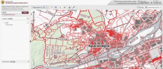
Public cadastral map
To familiarize the population with the characteristics of land plots, Rosreestr created an online public cadastral map (PCC). By logging onto the Rosreestr website, you can find the required area. For example, click the “Search” button and type the cadastral number in the search bar. Another option is to dial the site address.
After clicking the “Find” button, a table will appear with the main characteristics of the site (KN, address, land category, cost, area). The PKK will display a plan of this area, shaded in yellow.
“Measurement Mode” button you can estimate the coordinates of the point, the length of the boundaries, and the area of the site. Using the “Control” button, you can select the mode of images from space and evaluate the position of the site on the ground.
If the site has not been surveyed
Until the beginning of 2021, according to the law “On Dacha Amnesty”, it was allowed to register a plot without land surveying and in the absence of the PT coordinates of its borders approved in the Unified State Register of Real Estate. A large number of such plots are available in gardening partnerships (SNT).
This is due to the fact that in Soviet times plots were given out free of charge and they were not registered in the register, which did not exist at that time. According to the law on dacha amnesty, the state allowed such plots to be registered as property in order to somehow legitimize them and collect land taxes.
Since such plots are registered in the register, they have a cadastral number, cadastral value and other characteristics. But they do not have coordinates of the PT boundaries.
When requesting information about such a site on the PKK, for example, according to KN, a table appears with its main characteristics. But the note “Without border coordinates” appears on the table. In addition, a plan of this site will not appear on the map.
Conclusion
The appearance of the inscription “Without border coordinates” when requesting land plot parameters on the PKK indicates that this site is registered in the real estate register, but has not been surveyed and there are no coordinates of the turning points of its borders in the Unified State Register of Real Estate.
At the same time, the plan of this site will not appear on the map of the Rosreestr (PKK) website.
Determining boundaries through court
There are situations when the division of territory can only be done through the courts. Typically, this happens in the following cases:
- The neighbors did not approve of the boundaries and refuse to sign the agreement;
- The land survey took place a long time ago, but the owner does not agree with its result. This situation is not uncommon. For example, the neighbors decided to seize part of the land, and the former owner of your plot agreed without looking;
- At the stage of taking measurements, it turned out that the border runs through someone else’s territory. If the measurement has not been carried out for a long time, and the neighbors have occupied part of the site;
- Land surveying and division of land took place without the participation of the owner. For example, when he did not receive notifications about measurements.
If disputes arise, land owners in garden partnerships (SNTs), for starters, can contact the chairman (to resolve the issue peacefully), and if unsuccessful, go to court.
Arbitrage practice
Here are a few examples of lawsuits and their results:
Case 1
After taking measurements, the plaintiff sent documents to the Cadastral Chamber for further registration of the land. But he was refused due to the fact that his site already intersected with a nearby one, although no intersection was identified during land surveying.
The plaintiff demanded that the mistake in the neighbor’s papers be corrected, that the measurements be remeasured and new coordinates corresponding to reality be established. This requirement was satisfied by the court.
Case 2
The cadastral chamber refused the plaintiff's application to register the plot, citing the fact that it entered someone else's territory. During the investigation, it turned out that the neighbor illegally occupied part of the land, and his land surveying procedure was carried out with errors, as it was not agreed with the plaintiff.
The court made a positive decision and satisfied the applicant's demands.
Case 3
When trying to come to an agreement with the owners of neighboring plots and the location of the boundaries, the plaintiff was faced with misunderstanding and refusal. He explained this by saying that he exchanged land allotment with a third party and is now cultivating it, but when selling the allotment, the plaintiff was told that the border is located on this land, so a dispute arose.
The court rejected the claim and sided with the defendant.
From this we can conclude that going to court is not always a losing proposition. When a controversial situation arises and you know that you are right, filing a lawsuit makes sense, and most likely the judicial authorities will take your side after considering the details of the case.
What does the cadastral map show?
The map displays only land plots that are included in the Unified State Register of Real Estate with certain boundaries
. Registration of a plot in the Unified State Register is called cadastral registration. Determining the boundaries of a site, or land surveying, is one of the stages of such accounting. Until 2001, this procedure was not mandatory, so millions of plots were registered without coordinates (we even compiled a visual cadastral rating of regions according to border registration).
Owners often write to us when they cannot find their plot on the map. The problem cannot be ignored; it is fraught with difficulties in the future. Solutions depend on the specific situation.
Land surveying was done according to outdated legislation
Since 1990, land legislation has changed several times. The legal norm on a site map appeared only in June 2001, when the Law “On Land Management” came into force. In 2009, the Government established new standards for coordinate measurements. Therefore, the boundaries of plots demarcated before 2001, as well as in the period 2001–2009, may not be included in the Unified State Register and on the public cadastral map.
In this case, you may even have an old cadastral passport, where the site plan is indicated, but the coordinates of the corners will be missing:
Therefore, Rosreestr does not know where exactly your site is located and cannot display it on the map.
How to fix.
Carry out land surveying in accordance with current legislation by contacting a cadastral engineer. Then submit the finished boundary plan to Rosreestr through the MFC, paying a state fee of 350 rubles. The site will appear after the boundaries are registered in the Unified State Register and the cadastral map is updated.
Surveying carried out recently
You have carried out land surveying and registered the land survey plan in Rosreestr, but the site is still not on the cadastral map.
How to fix.
Just wait for the next map update. The public cadastral map is not updated in real time. The update speed depends on the regional divisions of Rosreestr. Some Offices upload to the map once a week, others several times a year.
Until the map is updated, you can take an extract from the Unified State Register to be sure that the borders are correctly taken into account by Rosreestr. The extract must contain section 3.2 “Description of the location of the land plot.” There you will find the coordinates of the corners of the site, even if it is not yet on the map.
Please note that the points in the statement are indicated in the local coordinate system - this is not GPS. To relate them to the actual map, use our survey calculator.
Consequences of unformed site boundaries
So, a land plot without coordinates is a territory that does not have a clear definition of its extreme points.
For the information of owners, setting boundaries independently does not guarantee their correctness. The fence may stand on a neighbor’s land, a private road, or occupy part of a municipal territory, for which you will subsequently have to pay a fine of 5 to 100 thousand rubles.
To determine the boundaries and so-called corners of the site, it is necessary to have a special cadastral engineer who takes measurements, determines the position of the site, and its coordinates on the map.
Before calling a specialist, you need to collect information about neighboring plots, coordinate the boundaries in such a way that there is no “overlap” of land on neighboring plots or, conversely, ownerless areas.
No land survey has ever been carried out
Until 2001 and in 2006–2009, legislation allowed the registration of real estate objects for cadastral registration without first determining their boundaries. For such plots, in the column “Special notes” of the extract from the Unified State Register it is indicated - “The boundary of the land plot is not established in accordance with the requirements of land legislation.”
Please also pay attention to the “Record Status” column. It will indicate that the information has the status “Previously recorded »
. Those. information about the plot was entered into the Unified State Register of Real Estate automatically from the old real estate register.
How to fix.
It is necessary to carry out land surveying in accordance with current legislation by contacting a cadastral engineer. Then submit the finished boundary plan to Rosreestr through the MFC, paying a state fee of 350 rubles. The site will appear after the boundaries are registered in the Unified State Register and the cadastral map is updated.
Errors in the cadastre
Sometimes, when registering a cadastral number, mistakes are made, either accidental or intentional, such as a neighbor’s unauthorized expansion of its borders. Such errors must be corrected immediately in order to avoid controversial issues in the future, when selling or renting out land.
Incorrectly entered data may be:
- technical;
- cadastral.
The first ones arise due to the fault of a cadastral chamber specialist, due to typos, incorrect entry of a surname, numbers, etc. The second is initially incorrectly submitted data, which is an illegal action.
Technical errors
They are eliminated by the specialists themselves upon detection, or at the request of the applicant, who needs to write appropriate statements to the cadastral chamber and the MFC, indicating in them:
- Last name, first name and patronymic of the owner, as well as his details: passport details, addresses, telephone numbers;
- If the applicant does not apply for corrections in person, then information about his representative is also required;
- A table is filled in, in which the first column indicates the name of the object and the error. In the second, the problem itself is described in detail, and in the last, the correct version of the outcome of the case.
Along with the application, a document with reliable information is submitted. This can be done in person or by sending papers by mail or through online resources.
Within 5 days, the Cadastral Chamber reviews and studies the application and, based on data analysis, gives an answer as to whether the documentation will be adjusted.
If the decision is positive, the owner will receive a new passport for the land. Otherwise, he will be provided with comprehensive information about the refusal. The reason for this may be:
- Incorrectly completed application or lack of confirmation of the problem;
- There is no error, perhaps the cadastral chamber already stores the correct information;
- The reason for refusal may be the identification of a non-technical error.
Cadastral errors
These are much more difficult to fix than technical ones. The process of verifying the authenticity of information and proving that the plaintiff is right can take quite a long time.
Such errors include:
- Incorrectly carried out surveys;
- Incorrectly specified addresses;
- Problems with documents establishing the type and category of land.
- Violations associated with the construction of a house.
To correct these errors, as in the previous version, you should submit an application and an attached document with the correct information to the registry office or the MFC.
There are cases when it is impossible to attach papers, because an error was made within the walls of the Cadastral Chamber or a dispute arose due to the determination of coordinates. In this situation, first, you need to go to court. And only by his decision is it possible to obtain a new cadastral passport.
Changes to the registry usually occur within 10 days. The chamber staff themselves may notice the mistake. Then they eliminate it on their own, and only pass on the relevant regulations to the owner and government agency about the need to eliminate the inaccuracy.
The main thing about areas without borders
If the boundaries of your site are not visible on the map, then most likely land surveying has not been carried out in accordance with current legislation. This does not deprive you of ownership of it. The law does not oblige the copyright holder to carry out land surveying. But selling such a plot will be more difficult. Rosreestr has the right to suspend registration of the transfer of rights and then the transaction will not take place.
It is important that unregistered boundaries reduce the market value of the property and provoke conflicts with neighbors. It is impossible to carry out legal construction on such a site. Therefore, we recommend conducting boundary surveys before the purchase and sale transaction, as well as when planning construction.
If your site is marked on the map, but the boundaries are incorrect, this is a different situation. It needs to be fixed urgently. We wrote about the reasons and methods in a separate article.
What to do if the coordinates are not set
If there is no information at all, that is, it is not marked anywhere, you need to call an engineer and take a measurement . You cannot do this yourself, as it will not count.
The procedure takes place in several stages:
- Inviting an engineer to carry out land surveying (determining sides and coordinates) and concluding an agreement for this procedure with a special company;
- Coordination with neighbors of the division of land and signing of the act of approval . This will avoid problems and further disputes. Usually there are no problems at this stage, especially if fences are installed between the lands. If consent is not obtained, you will have to go to court, but in the absence of any significant evidence (and this most often happens), it will be very difficult to prove your case;
- An engineer will visit, measure and determine the coordinates of its boundaries . After this, a survey file is drawn up in 2 copies: for the cadastral chamber and the owner;
- Applying to the chamber with an application to make changes and issue a new document based on land surveying;
- Receiving new papers.
The entire procedure will take about 1-1.5 months , but only if no difficulties arise during the process. The most problems may arise at the stage of coordination with neighbors: if the problem has to be resolved through court, this may drag on for several months, or even years .