Cadastral coordinates: what are they?
Cadastral coordinates are the coordinates of the location of a land plot: the width and longitude of each of its turning points, plotted on a public cadastral map.
Data on all registered plots is contained in the State Register and is available to their owners. You can get an extract from the Unified State Register of Real Estate and use the coordinates to determine the location of the land that belongs to you.
The document contains information about the area and boundaries of the plot, and you can compare it with the public map developed by Rosreestr for the convenience of landowners. This map is also located on the EGRNka portal.
The coordinates of the site are determined by cadastral engineers using tacheometers and modern GPS systems. They help set boundaries and prepare the necessary papers. The engineer records in the boundary plan the coordinates of characteristic points, the length and width of the corners of the site, and its area. The compiled documents are submitted to the cadastral registration authorities, and information from them is entered into the Rosreestr database and uploaded to the map.
When transactions are made or the area, location, or boundaries of the land change, the data is updated. They are available not only to property owners, but also to lawyers or realtors who participate in transactions or help conduct litigation.
Determination of parameters and area offline
Having the cadastral number of a plot of land or any other property, it is possible to determine:
- his address (coordinates),
- borders,
- square,
- other legal information.
All information is recorded by Rosreestr during the registration of the object. For this purpose, a nationwide database of cadastral numbers has been created.
All information on the cadastral number can be obtained in paper form in the form of a cadastral passport by an individual or legal entity directly from the Rosreestr department, the multifunctional center (MFC). To do this, you must make an official request at these institutions or through the post office.
You must also provide the following documents:
- check for payment of state duty;
- Russian passport;
- a document that certifies the applicant’s ownership of the land plot.
After submitting the entire package of documentation, the citizen receives a receipt, which will need to be presented to receive a cadastral passport.
The state duty for individuals is 200 rubles, for legal entities – 600 rubles.
In addition to the possibility of using a public cadastral map, it is possible to obtain information about a land plot by contacting specialists online. To do this, an electronic request is made on the official website of Rosreestr or on the State Services portal.
The document will also be provided electronically. The state duty for this service is 150 rubles for individuals, 300 rubles for legal entities.
You also need to provide scans of the remaining documents listed in the previous section.
Search via PKK
In order to find out the size of a land plot, having an address, coordinates or cadastral number, you can use the capabilities of the Public Cadastral Map of Rosreestr. This is a unique online service, using which an interested person can obtain all the necessary information about the requested object.
This web application is located on the official page of Rosreestr https://pkk5.rosreestr.ru.
In the search window, which is located in the upper left corner of the map, you need to select the “Plots” subsection and enter the cadastral number of the land plot.
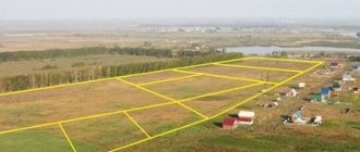
By clicking the “Find” button, the user will see that the map in auto mode will find and show the boundaries of the storage area in yellow, and in the adjacent window that appears, information about the object will appear, including the area defined in square meters.
The “Zap plan” option will help you save a drawing of the site.
If data about the site is not available on the PKK or the message “Without border coordinates” is displayed, then in the help window you need to contact a cadastral engineer to clarify the necessary parameters of the site.
In the process of executing the request, the dimensions and area of the plot will be clarified and provided to the user.
The dimensions of the area on the interactive map can be taken manually using the “Measurements” item in the left menu of the map. Next, without releasing the right mouse button, you need to mark the boundary line that needs to be measured. The result will be displayed under the “Measurements” button.
How to find according to the cadastral plan
A cadastral plan (passport) of a land plot is a document with legal force, which reflects data on the characteristics of a particular land plot.
Minimum and maximum size of land plot
In accordance with the letter of the Ministry of Economic Development of Russia dated March 21, 2011 N D23-1142, the maximum (maximum and minimum) sizes of land plots provided to citizens as property from state or municipally owned lands for peasant (farming) farming, gardening, truck farming, livestock farming , dacha construction are established by the laws of the constituent entities of the Russian Federation, for running personal subsidiary plots and individual housing construction - by regulatory legal acts of local governments (Article 33 of the Land Code of the Russian Federation). According to paragraph 1 of Art. 11.9 of the Land Code of the Russian Federation and Part 6 of Art.
If the size of a land plot provided to a citizen in the prescribed manner before the entry into force of this Law is below the minimum minimum size or exceeds the maximum maximum size established by Articles 1 and 2 of this Law, then for this land plot this size is the minimum or maximum, respectively. 3. For tax purposes, the maximum sizes of land plots previously provided to citizens for lifelong inheritable ownership are: for gardening - 0.12 hectares; for livestock farming - 0.20 ha; for dacha construction - 0.12 hectares. 4. This Law comes into force the next day after its official publication.
How to find out information through Rosreestr
Every citizen of the Russian Federation has the right to find out the cadastral number of any real estate property. Among other options, this can be done via the Internet by submitting an electronic request to the database on the official Rosreestr web page.
Let's look at step-by-step instructions for performing this operation:
Go to the Rosreestr page on the Internet https://rosreestr.ru/site/.
From the list.
Next, you need to enter the address and click the “Generate request” button.
Thus, the system will provide all the information of interest to the user: the address of the land plot and its cadastral number.
If necessary, from this last received page you can submit a request to the state cadastre to obtain an officially issued document on the property. The statement is provided in paper or electronic form. This service is provided for a fee.
What information can be obtained by cadastral number?
Many buyers are interested in the question of what land data they need to know? There are several points due to which the deal may be canceled
For example, it is important to know whether the property belongs to the same owner, whether there are co-owners whose age does not exceed 18 years, and whether the land plot has been pledged. If there are violations, the buyer may lose not only the object, but also the funds spent on its acquisition
Using the cadastral number, you can find information on a land plot that has not been used by anyone for a long time. The owner's contact information will be required if a neighbor wishes to annex the territory to his plot. Finding data is not difficult, some information is available to everyone.
In order to receive it, you need to make a request to Rosreestr. There is no need to go anywhere, all data is contained in the cadastral database.
A cadastral number is assigned to each property; without it, a transaction cannot be completed. If known, the following information can be obtained:
- Find out whether the plot was included in the cadastral database.
- About what status the territory has. Its area.
- Are there any buildings on the site? What are they, how many are there?
- Check the territory for encumbrances (for example, easements).
- The exact address. Cadastral value.
- Date of registration of the allotment and form of ownership.
- Has the information been updated?
- Information about the specialist who performed cadastral work. Land survey date.
- Purpose of the site. What can you use it for?
Data collection is required in order to guarantee the purity of the transaction and to prevent conflicts arising around the topic of land surveying and drawing the boundaries of the territory. The information contained in the database assigns to the owner of the allotment his rights to the territory and guarantees their inviolability. This ensures safety and guarantees the safety of property.
What is enshrined in law
The main legal acts regulating at the federal level the minimum and maximum sizes of plots for individual housing construction are the Land Code (Article 11.9) and the Town Planning Code of the Russian Federation (Article 30). Limit values are set to ensure that land is used in the most rational way.
The provisions of these codes contain general requirements that must be observed by local governments when they issue relevant regulations.
Important! When a land plot that is owned by the state is provided, its size is influenced by the following factors:
- in relation to plots of land that are federal property, the sizes are established by acts of the Government of the Russian Federation,
- in relation to plots of land that are allocated for construction on preferential terms, the sizes are determined at the level of the constituent entities of the Russian Federation,
- in relation to plots of land that are provided for private development, the sizes are determined by the administration of the municipality.
At the level of the constituent entities of the Russian Federation, the maximum sizes of plots are determined, and they must comply with federal legislation.
Attention! Our qualified lawyers will assist you free of charge and around the clock on any issues. Find out more here.
The established parameters must be included in the “Land Use and Development Rules” and town planning regulations.
As a rule, the maximum size of plots for individual housing construction varies in the constituent entities of the Russian Federation, ranging from 3 to 30 acres. There are constituent entities of the Russian Federation in which the minimum plot size is several times higher than the national average.
Factors influencing the area limits of a plot of land are the following:
- area of the subject of the Russian Federation and free territory,
- degree of development of the territory,
- Population,
- demand for plots.
If you need to clarify the maximum size of certain plots, contact the administration of your locality.
How to draw up a statement of claim to the court on land issues?
How a disabled person can get a plot of land for free, read here.
How to divide a plot of land with a house into two owners, read the link: https://novocom.org/zakony-i-prava/zashhita-pokupatelej-nedvizhimosti/zhilaya-nedvizhimost/kak-razdelit-zemelnyj-uchastok-s-domom- na-dva-xozyaina.html
Information from the cadastral map of Russia and all regions of the country
Individuals online have the opportunity to receive the following information from the Rosreestr cadastral map:
- cadastral district - as a rule, general information is similar to the boundaries of the constituent entities of the Russian Federation;
- information about regional taxation objects - corresponds to the territorial boundaries of a city district or municipal district, as well as urban-type settlements; in some cases there may be minor errors;
- quarterly cadastre - represents regions on a large scale corresponding to cities, villages, towns, as well as forests and gardens;
- plots – characterized as the smallest units of cadastral type; include land plots located in the interior of garden partnerships and located within private buildings; includes information regarding the location of streets within small settlements.
At the same time, based on the resolution of the Russian Federation, the cadastral map has a special legal status. It is the first declaration of the current Real Estate and Road Data Council in our country. The cadastral map is used for the purpose of completing signatures and includes information about possible problems in using and obtaining cartographic information.
Maximum permissible size of a land plot in the Moscow region
LAW OF THE MOSCOW REGION ON THE LIMIT SIZE OF LAND PLOTS PROVIDED OWNERSHIP TO CITIZENS IN THE TERRITORY OF THE MOSCOW REGION (June 17, 2003 N 63/2003-OZ) June 17, 2003 N 63/2003-OZ Adopted by resolution of the Moscow Regional Duma dated 28 May 2003 N 3/59-P LAW OF THE MOSCOW REGION ON THE LIMIT SIZES OF LAND PLOTS PROVIDED TO CITIZENS IN OWNERSHIP IN THE TERRITORY OF THE MOSCOW REGION This Law was developed in accordance with the Land Code of the Russian Federation and establishes the maximum (maximum and minimum) sizes of land plots provided to citizens in ownership from lands in state or municipal ownership for conducting peasant (farm) farming, gardening, truck farming, and summer cottage construction. Article 1. Voskresensky individual housing construction in Voskresensk and villages 0.06 0.15 Individual housing construction in the village 0.08 0.3 Household private household plot in Voskresensk and villages 0.06 0.15 Household private household plot in the village 0.08 0.3 Field private household plot 0, 1 0.3 3. Dmitrovsky For individual housing construction or private household plots 0.02 0.15 For gardening 0.02 0.12 4. Istrinsky individual housing construction in Istra, Dedovsk and the village. Snegiri 0.06 0.15 Individual housing construction in the village 0.06 0.3 Private household plots 0.06 0.5 5. Klinsky individual housing construction 0.05 0.3 Household private plots 0.05 0.3 Field private plots 0.5 1 6. Kolomensky Individual housing construction and private plots in the village of Peski 0.05 0.2 Individual housing construction and private subsidiary plots in the village 0.05 0.3 Field private household plots 0.05 2 7. Leninsky individual housing construction in the city of Vidnoe 0.06 0.15 Individual housing construction except for the city of Vidnoe 0, 06 0.25 Private household plots in the city of Vidnoe 0.06 0.15 Private household plots except for the city of Vidnoe 0.06 0.25 8. Lotoshinsky individual housing construction in Lotoshino 0.04 0.2 Individual housing construction in the village 0.04 0.5 Household private household plots in Lotoshino 0.06 0.2 Household private plot in the village 0.06 0.5 Field private plot 0.06 0.5 9. Mozhaisk individual housing construction 0.04 0.12 Private plot 0.04 0.3 10.
Where can I see the boundaries of a land plot?
Online way to obtain information
You can determine the previously established boundaries of a land plot (LP) registered with the cadastral register on the website. This is done as follows:
- Find the area you need on the map.
- Or having a cadastral number/address, etc. In the upper left part of the screen, select the “Magnifying glass” tool and then “Plots” - enter the cadastral number in the field that appears and click the “Find” button.
This is what your borders will look like:
If disputes arise with your neighbors, you can show them a screenshot of the boundaries indicated on the map. You can also use them as an appendix to the rest of the documentation defining the boundaries. But this information also does not have independent legal force.
If the plot is not registered with the cadastral register, online information will not be provided. The same applies if they are not included in the current program.
If you want to expand the boundaries with the help of clarification, then our other material will contain useful information for you.
Study the available documentation for the memory
If the owner or other title holder of the land has drawn up documents for the land in good faith, then they can contain information about the boundaries of the land plot. Such documents include:
- certificate of the form of right to land plot;
- cadastral passport of the land plot;
- land surveying;
- other cadastral documentation.
Copies of these documents and their originals are fully legal to resolve land disputes, including in court, and determine red lines before the start of construction.
The main documents are the papers drawn up by the cadastral engineer during land surveying:
- the act of agreeing on boundaries with neighbors;
- act of transfer of boundary marks;
- cadastral plan of the land plot.
Act of approval of the boundaries of a land plot: form, sample filling.
Example of a cadastral plan for a land plot
From them you can obtain completely reliable and legal information to resolve all issues related to the passage of boundary boundaries.
How to find out the boundaries of your land plot in Rosreestr?
If the cadastral passport was received more than three years ago, or at the request of the authorized authority, a cadastral extract indicating the coordinates of the turning points is presented. This information is received by the State Real Estate Cadastre (GKN) in accordance with the Federal Law adopted on July 24, 2007 under No. 221-FZ.
To obtain it you need:
- Go to the cadastral office or multifunctional center (MFC) at the location of the plot.
- Get an electronic queue coupon. It is permissible to make an appointment in advance by filling out an application on the government services website.
- Pay a state fee of 200 rubles.
- According to the coupon or registration time, go to the registrar window and write an application for the issuance of information about the location of the boundaries of the storage area.
- Present your civil passport and certificate of ownership of the land plot.
- After 5 working days, come for a follow-up appointment and receive the completed document.
The resulting extract will contain current and legal information about the boundaries of the allotment. But if the boundary of the land plot has not been established earlier, the extract will indicate that the boundaries of the plot at the corresponding address have not been established.
Unlike information posted on the website in the public domain, information from the State Property Committee is not disclosed to third parties.
Sample cadastral extract about land plot
Maximum minimum size of land plot in the Moscow region
Adopted by Resolution of the Moscow Regional Duma of May 28, 2003 N 3/59-P OF THE ZAKONMOSKOVSKAYA REGION ON THE LIMIT SIZE OF LAND PLOTS PROVIDED TO CITIZENS FOR OWNERSHIP IN THE TERRITORY OF THE MOSCOW REGION This Law was developed in accordance with the Land Code of the Russian Federation and establishes the maximum (maximum and minimum) sizes of land plots , provided to citizens as property from state or municipally owned lands for conducting peasant (farm) farming, gardening, vegetable gardening, and summer cottage construction. Article 1. The PP indicates that in none of the territorial zones of the city are minimum and maximum sizes of land plots established. The situation is different in the Moscow region. Thus, the Land Use and Development Rules adopted in the city of Roshal (approved by the Council of Deputies of the Roshal City District of the Moscow Region dated January 23, 2017 No. 1/28) introduce minimum plot sizes for
- mid-rise buildings - apartment buildings within 8 floors (minimum plot size - 5000 sq.m., maximum - 500,000 sq.m.
); - low-rise multi-apartment development - housing within 4 floors (minimum plot size 2500 sq. m, maximum - 100,000 sq. m);
- individual residential development - houses for 1 family no higher than 3 above-ground floors (minimum plot size - 300 sq.
If the size of a land plot provided to a citizen in the prescribed manner before the entry into force of this Law is below the minimum minimum size or exceeds the maximum maximum size established by Articles 1 and 2 of this Law, then for this land plot this size is the minimum or maximum, respectively. 3. For tax purposes, the maximum sizes of land plots previously provided to citizens for lifelong inheritable ownership are: for gardening - 0.12 hectares; for livestock farming - 0.20 hectares; for summer cottage construction - 0.12 hectares. 4. This Law comes into force the next day after its official publication.
5. The same bodies determine the minimum sizes of plots that are in municipal ownership. The standards may vary, but must ensure the operation and maintenance of existing buildings on the sites. The lower limit is 0.02 ha. Regions, regions, and constituent entities of the Federation have their own regulatory documents that establish maximum standards for the provision of land plots to citizens for their own needs or to legal entities for construction purposes. LLC ReLiKom lawyer on the website Chetoeva E.A. lawyer on the website Rudenko A.A. lawyer on the website Bayramov Z.A. lawyer on the website Okulova I.V. lawyer on the website Telezhkin I.B. lawyer on the website Justice-Right lawyer on the website Kuznetsov A. S. lawyer on the website Popov N.A. lawyer on the website Kiselev R.V. lawyer on the website Matayev A.G. lawyer on the website Medvedev V.V. lawyer on the website Cherepanov A. M. lawyer on the website Hello, dear guest! There are currently 185 lawyers on the site.
Method number 3 - download the KadastrRU application
The most convenient and advanced way to find a land plot by cadastral number on a map online is using a smartphone. To do this, download and install the free mobile application “KadastrRU” from the AppStore or GooglePlay.
The main feature of the KadastrRU application is the ability to see your actual location on the cadastral map. That is, it is possible to determine the geographical location, boundaries and area of a land plot on the ground without topographic work. Of course, the accuracy of such measurements is conditional. The KadastrRU application is indispensable for determining the real location of a plot before purchasing it. The disadvantages include the need for a stable 3G or LTE connection.
Division of a land plot is an action as a result of which two or more land plots are formed from one plot of land. During division, the land plot from which new land plots are formed ceases to exist.
A land plot can be divided on the basis of an agreement on the division of a land plot with the consent of all its owners (if there is no dispute) or by a court decision where an interested person files a claim. The Land Code of the Russian Federation establishes requirements for created and modified land plots. The formation of land plots should not lead to wedging, interspersing, broken boundaries, interstriations, the impossibility of placing real estate objects and other shortcomings that impede the rational use and protection of land, and also violate the requirements established by the Land Code of the Russian Federation and other federal laws. The newly formed land plots must meet the requirements for the maximum size of land plots of a certain category. The maximum (maximum and minimum) sizes of land plots are determined by town planning regulations or land legislation (in relation to plots to which town planning regulations do not apply). The maximum (minimum and (or) maximum) sizes of land plots and the maximum parameters of permitted construction and reconstruction of capital construction projects include the maximum (minimum and (or) maximum) sizes of land plots, including their area. Land use and development rules are approved by regulatory legal acts of local government bodies. Thus, both during the initial provision of a land plot to citizens, for example, for individual housing construction or for personal subsidiary plots, and during its division, the resulting land plots must comply with the requirements of the law, preserving the intended purpose and permitted use of the original land plot, including the corresponding minimum and maximum limits sizes. To divide the land plot, it is necessary to carry out land surveying. When establishing the boundaries of a land plot on the ground, the owners, possessors or users of the land plot whose boundaries are being surveyed, as well as the owners of adjacent plots, must be present. The cadastral engineer establishes the boundaries of the resulting land plots and draws up a boundary plan, which indicates the location of the resulting land plots. After preparing the boundary plan, you can begin to draw up an agreement on the division of the land plot. An agreement on the division of a land plot is drawn up in simple written form and signed by all co-owners of the divided land plot. If desired, the agreement can be certified by a notary. The agreement must indicate the address and cadastral number of the land plot to be divided, information about its owners (full name, passport details, registration addresses at the place of residence, telephone numbers, etc.). The agreement indicates that the owners of the land plot have decided to divide it, and also describes how the division is made (in proportion to the shares in the common property right or in another way). Actions to divide a land plot entail certain material costs, therefore the agreement stipulates how the parties will bear the costs of state registration of ownership of the formed land plots. If one or more owners of a land plot do not agree to enter into an agreement on its division (there is a dispute), you will have to apply to the district court at the location of the land plot with a claim for its division. After concluding the agreement, it is necessary to submit an application for assigning addresses to all newly formed land plots to the authorized local government body or government body of the constituent entities of the Russian Federation - cities of federal significance. An application for assignment of an address can be sent in person or through a representative: - by mail; — through the MFC; — in the form of an electronic document, including through the Unified Portal of State Services, the regional portal of state and municipal services (functions) or the portal of the federal information address system via the Internet. The decision to assign an address to newly formed land plots or the decision to refuse such assignment is made within no more than 18 working days from the date of receipt of the application. After this, you can contact Rosreestr for cadastral registration and registration of ownership of the formed land plots. When dividing a land plot, state cadastral registration and state registration of rights to the formed land plots, as well as deregistration and termination of ownership of the original land plot are carried out simultaneously. For state cadastral registration and state registration of rights to formed land plots, the following documents are submitted to the Rosreestr division: 1) passport; 2) an application for state cadastral registration and state registration of rights to land plots; 3) a decision on the assignment of addresses issued by an authorized local government body; 4) an agreement of owners or a court decision on the division of a land plot that has entered into legal force; 5) a document confirming authority, if the application is submitted by a representative of the owners. A state fee must be paid to register ownership of land plots. The application and the necessary documents can be submitted to Rosreestr in one of the following ways: - directly to the Rosreestr branch or through the MFC (regardless of the location of the property according to the list of units that carry out reception on an extraterritorial basis posted on the Rosreestr website) or to an authorized person of Rosreestr during on-site reception ; - by postal item with a declared value when forwarding it, a description of the contents and a notification of delivery (in this case, the authenticity of the signature on the application must be notarized, the agreement and power of attorney of the representative must be notarized, and copies of identification documents must be attached); - in the form of electronic documents via the Internet using the official website of Rosreestr. State registration and cadastral registration are certified by an extract from the Unified State Register of Real Estate, which can be sent electronically.
Saving the information received and requesting expanded information from the Rosreestr website
To save the information received, you must follow these instructions:
- Add the result that the search engine provided to your “favorites” - click on the star located opposite the line with the result. You can add one object to this list, or several, or all. You can also remove the star from the document and remove it from your favorites list.
- Save the list. By clicking on the button with the image of loading or unloading file information, you can save the search results. The file format that will be saved on the PC is “csv”. Thus, you can not only save information, but also enter your list into the system.
In order to obtain other information, you will need to contact the state cadastre service in person, or go to the online website of Rosreestr, where you select the name of the service that you need.
We hope that our recommendations for using the online cadastral map service of Russia will be useful to you. Now, with the advent and development of Internet technologies, it is much easier to find out information.
How to view the cadastral plan of a territory by cadastral number
You can view the cadastral plan remotely on the public cadastral map of Rosreestr, located at https://pkk5.rosreestr.ru. This service allows you to obtain a wide range of information regarding land plots online absolutely free of charge. It contains cadastral information that is publicly available to all interested parties. Some information is not available here for obvious reasons, in particular the owner’s full name and passport details.
In order to find the area of interest and see its cadastral plan, you can use two search options:
- by cadastral number;
- to the exact address of the land plot.
The algorithm for obtaining information about the cadastral plan of the site will be as follows:
- You need to open the public cadastral map located at https://pkk5.rosreestr.ru. The map is available to all interested parties and is accessible to everyone.
- In the left corner there is a search line where you need to enter the cadastral number. The cadastral number has the following format: XX:XX:XXXXXXXX:XX. Please note that the search must be carried out by the “Plots” category (usually it is set by default).
- If the cadastral number was registered correctly, then a card of the land plot and its schematic image will open. The selected area will be highlighted in yellow, its borders will be highlighted with a red line. The scale of the object can be adjusted: when it is reduced, the user will have access to the surroundings of the site and its closest neighbors. If desired, the scale can also be increased.
- The card of each plot contains information indicating the primary cadastral registration data: cadastral number of the plot and quarter, its area, cadastral value, form of ownership (private or public), full name of the cadastral engineer who was responsible for land surveying, date of cadastral registration. The map also provides access to various services online, in particular, to obtain an extract from the register or clarify information about a property.
To obtain a cadastral plan of the land plot, you need to click on the “Land Planning Plan” tab. There is also a tab nearby that allows you to see the plan of the cadastral quarter.
The site plan will look like this:
What is a cadastral passport of a land plot?
At its core, a cadastral passport is an extract from the real estate cadastre. The document contains all the characteristics of the site, including the owner, as well as all possible encumbrances, information about its state registration in the register. Consists of 5 sections.
First. Land characteristics:
- Assigned number (cadastral). Unique property identifier. During the period of the object's existence it does not change. Indicates that the object is taken into account by the state and its location. It is a set of numbers, the last three of which are the number of the site itself. The rest are his location in the country.
- Where is. The exact address.
- Category. That is, for what purposes is it allowed to be used?
- Purpose of use (permitted). For example, for housing construction.
- The area has been put on.
- Tax (land, its size).
- Price. Usually the registry-defined one is indicated, i.e. the basic one. Actually, market calculations of the price of land are based on this value.
- Owner. His rights to this property.
Second part. Plan in graphical representation. Attached only when the area is demarcated. If not, then a corresponding note is made indicating the absence of established boundaries.
Third. List of encumbrances. In the event that they are present. Tax debt, easement, etc.
Fourth section. Allotted borders after demarcation. Refined angles and dimensions.
Fifth. Refined turning points of boundaries (established).
What might it be needed for?
You cannot do without this document in cases where:
An inheritance is formalized, and the allotment is included in it. In litigation
For example, the rights of the owner were violated when determining the boundaries of the site. The land is transferred into the ownership of a citizen (purchase/sale or redemption, it does not matter). Before construction begins on the site. When boundaries change. Change of allotment address. The area changed its name, etc.
n. When insuring the site itself and the buildings located on it. In case of bankruptcy. When registering a property pledge. In case of compensation for damage caused by nature or other catastrophic actions. When is a land lease issued? Contribution to the authorized capital of the company being organized.
The value of the size of an agricultural plot
Please note! This value is set at the regional level. In particular, in the territory of the federal city of Moscow, the minimum sizes of plots are established in accordance with the Government Decree of May 28, 2003.
On the territory of Moscow, land plots with agricultural purposes must be no less than a certain value. It depends on the purposes for which the site is used.
The following dimensions are established:
- for gardening of at least 0.06 hectares,
- for gardening of at least 0.04 hectares,
- for farming of at least 2 hectares,
- for the construction of a country house and other real estate of at least 0.06 hectares.
Registration of a land plot from lease to ownership.
Definition using Internet resources, types of maps
If you are facing any real estate transactions, a dispute has arisen with neighbors regarding the boundaries of the territory, or there are other circumstances that require immediate clarification of the boundaries of the site, you can resolve the issue by using one of the Internet maps.
Public card
The easiest way to determine the boundaries of the desired area is to use a public cadastral map. It was created by Rosreestr specialists and it displays the latest data about the plots and their boundaries.
Users are given the opportunity to see what a particular territory looks like, while the new site makes it possible to overlay the diagram directly on the map, which will allow them to clearly see the plot and its boundaries. Now Rosreestr makes it possible to use the following types of cards:
- Yandex maps. The Rosreestr website also contains Yandex.Map, where you can also see the boundaries of a plot and find it by cadastral number. It differs from the previous one in its more convenient Zoom and the presence of both a schematic representation of the territories and satellite images.
- Google Maps. It allows you not only to view a diagram or satellite map with marked boundaries of territories, but also gives you the opportunity to look at the appearance of the site as if you were standing right in front of it on the street. It is the ability to take a virtual trip through any city that Google Maps is famous for.
- OpenStreetMap. The service positions itself as created by the users themselves. It does not show cadastral marks, but it provides an excellent opportunity to look at photographs of plots that are being added by project participants. This can be a great help if you intend to buy land and are just looking at real estate.
- 2GIS. Initially, the service contained information about buildings and city organizations, but later it joined the Rosreestr program and provides its own schematic map.