Most owners of private land are interested in the question, what is the building line? The red building line is a design line that demarcates a plot of land intended for construction from public territory.
It is marked in red on the map, which is where it got its name. It is established by the local administration in the form of regulations.
Before starting construction work, it is necessary to know its exact location, since all activities related to the construction of private and public structures cannot be carried out in any order.
Peculiarity
State standards state that objects must be located within the red line. Privatization of buildings installed in violation of these boundaries is not permitted by law. Its main feature is that it delimits not a separate plot of land, but an entire block of land territories.
ATTENTION! It is worth noting that the areas outlined by the red line may be located inside land intended for development.
This occurs in the following situations:
- When high-voltage transmission lines pass through this land.
- Pipelines.
- Gas and heat pipelines, or similar structures.
Thus, even privatized areas may have areas marked with red lines. Construction is not permitted inside these zones. When deciding where to build a building line, one takes into account not only what is currently on the ground, but also what will be built there in the future.
According to the law, during the construction of a facility certain conditions must be met:
- All buildings on the land plot must be erected within the building line.
- The object must be within 2-3 meters from the red line.
The exception is premises for public needs. Their construction directly along the building line is permitted.
Boundaries of red lines
How to determine exactly where the building line lies, since there are no boundaries on the site itself? Information can be obtained in several ways:
- Make a request for a general development plan from the cadastral organization or ask for a situational plan of the land.
- Seek help from a land surveyor to help you determine boundaries.
Red and other lines of urban planning regulation must be taken into account and reflected in documents such as:
- General plans, development projects, as well as detailed planning.
- In urban planning and land cadastre.
- Highway planning projects, locations of squares and streets, transport and engineering communications.
The red line project must be agreed upon and approved in urban planning documents.
Where can you see the lines of urban planning regulation
What is a building line according to the town planning code? Where can you see the lines?
It is very doubtful that anyone will be able to see the original master plan for the development of a particular settlement. This is not one sheet of paper. This plan is stored in the archives of the urban planning department.
There is also an electronic plan for such regulation. There, with the help of technical means, adjustments are made to the basic plan. Such a plan is available to the public on government portals.
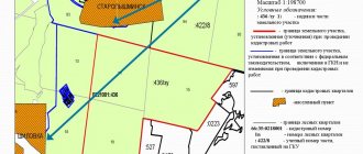
The results of the work of surveyors and management are reflected in the government decree, which clearly delineates permissible zones for construction, water protection zones, and cultural sites by name and zone. It's actually a huge drawing with red and blue lines. Lines are divided by type:
- red lines – the road network, beyond the boundaries of which the developer is prohibited from trespassing;
- transport infrastructure and its facilities. These include parking lots, vehicle parking areas, turning areas;
- boundaries of railway right-of-way;
- non-stationary construction sites (gas stations, service stations, car wash complexes);
- objects of trade, defined as “individual non-stationary objects of associated services for the population.” These include markets, spontaneous markets, stalls and LAFs;
- building lines - boundaries allowed for a construction site and the adjacent territory;
- blue lines – boundaries and zones of water resources of a populated area;
- technical zones and metro zones (if provided);
- boundaries of protected areas;
- boundaries of historical and cultural centers;
- boundaries of sanitary zones. These zones are divided into three categories (zones) according to the degree of danger;
- boundaries of man-made objects. These include factories, stations and substations
Application mechanism
The Town Planning Code and SNiPs establish standards according to which they determine the places where a residential building and buildings for economic purposes can be erected.
Until 2015, there was a dacha amnesty, according to which the construction of buildings was first allowed and only then was it legalized by local authorities. At the same time, they often did not pay attention to the fact that the norms related to compliance with the building line were not taken into account.
Currently the situation has changed. Now an illegally erected building can be demolished by court decision. What needs to be done to prevent the building from being demolished? Basic actions:
- Collect all necessary documentation indicating the location where the construction of a residential and commercial building is proposed.
- Apply documents to the local administration to obtain permission.
- Carry out construction work in accordance with the completed papers.
It is also worth observing fire safety regulations.
Mechanism of use
The standards for the placement of houses and utility blocks are regulated by the provisions of the Town Planning Code. Their explanation and definition is found in the building codes in accordance with the issues that arise. This means that inside his own plot, the owner cannot, at his own discretion, place a house and barn in any place he likes.
Until 2015, there was an unspoken amnesty, which involved the legalization of unauthorized buildings by local governing bodies. The attitude towards regulatory requirements was lenient. Recently, in order to formalize documents for a building that has already been erected without permission, a decision from the judicial system is required.
The jury does not always make a positive verdict and in its work is guided by the rules and regulations of the development. This leads to the fact that the built house or utility blocks may be intended for demolition. Such decisions are made even in cases where the land is privately owned.
There is a mechanism for determining the red line
The owner of a plot of land encounters the concept of a red line at the initial stage of obtaining a permit and developing a project for individual construction of a house. Further passage of the authorities goes according to plan, and the owner of the site provides the local municipality with:
- A cardinal plan of the land plot with the connection of the structure under construction to the existing terrain and the red line on the general plan indicated on it. Attaches a cadastral passport of the land.
- A photocopy of the urban planning map with the outline of those boundaries, taking into account which the location of the building is selected.
- A site development plan, professionally or in-house, with the distance marked from the red line of streets and alleys to the border of the future house. On the schematic representation of the plot attached to the cadastral certificate, the required line is not shown.
- A note with explanatory text.
After accepting the package of necessary papers, the local government authority issues a permit to build a house.
Regulations
Before determining the red line of a site for a number of village plots for construction, the relevant documentation is put in order. This includes the following papers:
- SPOZU is a schematic layout for organizing a plot of land. Before the construction of the house begins, the document records the position of the red border, which determines the permitted territory for construction.
- GPZU is an urban planning project for an allotment that defines in detail the outlines of the future development of the microdistrict.
Topographical identification elements are drawn on a photocopy of the required section of the map, which are located in the designed area. These include:
- high-rise buildings;
- sports and cultural buildings;
- squares;
- lawns, parks;
- streets and neighborhoods;
- roads and passages.
Elements include, for example, a road.
The task of the department of urban or regional architecture is the successful location of the real estate object, its harmonious fit into the landscape of the territory permitted for development. The customer collects the necessary documents indicating the place of housing, applies to the municipality to obtain a permit, builds a house taking into account the drawing and project.
Responsibility for breaking a trait
Basing a building on a site that deviates from the regulatory requirements specified in the project leads to the recognition of illegal development if the distances from the red contour are not observed. In most cases, responsibility is administrative in nature.
Options for demolishing a new building are also common if the size of the deviation from the rules requires it. Sometimes the decision to dismantle comes as a result of legal proceedings.
House location standards
Constructions are not only located inside the territory marked with a red line. They are provided with a certain distance. Basic rules for the location of buildings relative to the boundary line:
- The fence protecting the yard space may coincide with the boundary, but the building itself must retreat from it by five meters. This rule is valid for a boundary if it separates a street and a plot of land. The concept of street includes a carriageway and a pedestrian sidewalk.
- If the boundary of the site does not coincide with the red border, then the minimum distance to it is three meters.
- Large trees should not be planted closer than four meters.
- Shrubs taller than half a meter are located no closer than five meters from the road.
- Tall vegetation should not obstruct the passage of ambulances and fire trucks. Plants should not interfere with the lighting of the home.
- For buildings in which public services and shops are located on the ground floors, other placement rules are provided. Their front wall may coincide with the red line.
- When calculating the distance to the red line of the road, not only the walls of the house are taken into account, but also its protruding structural elements. This is taken into account at the design stage, since the regulatory gap may be violated by a wide roof overhang.
- Outbuildings are usually located in the depths of the land plot. But if the red line runs close to them, then the location of the blocks is also subject to regulatory rules.
- Outbuildings are tripled so that the distance between their walls and the fence is at least one meter.
- If the red border passes inside the land plot, any construction on the site is not permitted.
Requirements for the installation of fencing
The norms for the distances of fences from the red boundary are different and depend on their location on the plan. For protective fences of the yard area running next to the control line , the following requirements apply:
- The installation location will be agreed upon with the city management committee for architecture and construction.
- It is not permitted to use hazardous materials that could cause injury to passers-by for the construction of the fence. These include unplaned boards, hazardous waste, barbed wire, etc. There are no restrictions for other certified materials.
- The height of the protective barrier should not exceed 2.2 m.
- When the fence is located along the street, the leaves of the gate and entrance gate to the site are allowed to be hung with opening inward. For external opening, there is a requirement that the fence be located at a distance of at least one meter from the limiting red line.
Failure to comply with the standards for the location of the fence leads to an administrative fine. The state agency for supervision of construction or the owner of a neighboring plot can certify and present violations if his rights of ownership are violated as a result of improper construction of the fence.
The size of the fine depends on the size of the deviation from the rules. The protective structure may be declared invalid. The owner will dismantle it using his own funds. Before starting construction of housing on the land, you need to complete the required documentation. Because of such actions, conflicts with supervisory authorities and neighboring owners will be reduced to zero.
Norms
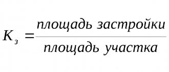
The main purpose of the red line is that it defines the territory in which construction is permitted.
On personal plots, residential buildings can be placed at a distance of 4-5 meters from the building line. This distance makes it possible to protect the house from noise and dust from the street.
Complying with the rules is not difficult. To obtain permission to build a capital facility, it is enough to provide a site layout diagram. Its boundaries, red lines, as well as the designed object are indicated there.
Several factors influence the fire distance. If we are talking about a residential building, then the distance is determined based on the material used in construction and the ceiling of the house.
To ensure fire safety, the average distance between residential buildings should be from 6 to 15 meters. Building regulations contain the following required distance between residential buildings :
- If houses are built from non-combustible materials, which include brick, reinforced concrete or stone, then the distance between them must be at least 6 meters.
- If there are wooden floors - 8 meters.
- For wooden houses, as well as houses made of non-combustible materials, the distance must be at least 15 meters.
The calculation is carried out based on the most prominent points. Basically this is a porch or bay window. Regulatory documents provide recommendations for the placement of a residential building with an offset to the lateral boundaries of the plots.
The minimum distance from the fence to the outer wall of the building should be at least 1-1.5 meters. Outbuildings must be located 5 meters from a residential building. Outdoor toilet, shower, natural wells - at least 8 meters. The distance to the electric telephone cable should be 60 cm.
ATTENTION! During the design and construction of a garage, in order not to violate the boundaries, it is advisable to determine the distance to the building line with the entrance gates wide open. The design must indicate how the external fence is located.
Buildings for poultry and animals may be attached to a residential building, but they must be separated from living rooms at a distance of at least three utility rooms. They should not exceed 2.4 meters in height.
It is possible to adjust the location of the building line, but this is not an easy procedure, the result of which will depend on municipal and state authorities.
Distance from building line to red line
SNiP regulates the placement of buildings and structures as a construction, which certainly takes into account the existing project and the red lines that are defined in a given locality.
Standards for building between individual wooden multi-storey buildings
It indicates how many meters must be so that a fire truck can pass. The existing network of engineering and technical communications and special facilities are also taken into account. Distancing from them is mandatory when building a residential building, and it is built with a mandatory indentation.
The residential building is set back from the red line of the road at least 5 meters, from the lane at least 3 m.
The same thing happens when an individual house is built. According to SNiP, it must be separated from the boundary of the neighboring plot and the red line of the street at the same three-meter distance. Failure to comply with established standards and arbitrary development of individual land property can easily result in litigation or demolition after its resolution.
Standards for placing a house relative to the road in SNT and individual housing construction according to SNiP (SP)
So, according to SNiP (SP) standards, a private house should be located no closer than 3 meters from the neighboring plot. Outbuildings – at a distance of 1 to 4 meters from the neighbors’ land plot. The setback for outbuildings should be 5 meters from the road, and 3 meters from the driveway or alley.
According to SP standards, the building line must be at a distance of at least 2 meters or more from any other red lines.
Where are they used?
These boundaries must be respected during the following events:
- Construction of buildings and structures.
- Land marking.
- Creation of construction projects.
- Development of new sites that have been allocated for construction.
- Registration of ownership of a property.
- Inventory of plots with buildings located on them.
The red line is taken into account when preparing documents such as:
- Development of plans for certain territories.
- Description of the rules for using land plots.
- Allocation of part of the land for the construction of a new building.
- Drawing up a Master Plan for the construction of the building.
If there are no red lines on the documents, then they need to be outlined and approved in the required order.
Responsibility for violation
Construction carried out without complying with the standards may lead to the recognition of the building as illegal and its further demolition.
IMPORTANT! In the event of damage to neighbors, legal proceedings may begin, as a result of which a decision may be made in favor of the plaintiff, and the offender may be awarded compensation for the damage caused.
It is worth knowing that even if all construction requirements are met, there may be incompatibility between the built house and the neighboring site.
It may also turn out that the walls of the constructed building will not violate the standards, and the roof will overhang the neighboring territory. In such a situation, penalties may be imposed. Most often, the responsibility is administrative in nature.