What is a cadastre - in simple words for dummies
Most often, the cadastral chamber is asked about how to protect against fraud during real estate or land transactions. You are probably well aware of the cases when Russian cinema, theater, pop or sports stars become victims of scammers. Despite all its rich possibilities.
How to avoid becoming a victim of scammers? How to check the authenticity of documents and what you need to pay the necessary attention to?
What the copyright holder should pay attention to. One of the steps to protect against fraud may be to submit an application to Rosreestr stating that all transactions with real estate owned by him can only be concluded with his personal participation.
Such an application can be submitted both on the Rosreestr portal, on the Internet information telecommunications network, and in any of the cadastral chamber offices, or in any of the offices of multifunctional centers (MFC).
Please note that in order to protect your property located outside the region or at the other end of our country, it is not necessary to travel to the location of the property. Such an application can be submitted at any of the territorial offices of the mentioned organizations, anywhere in our country.
If the copyright holder is registered on the State Services website, he has the opportunity to track the condition of the property he owns in the so-called “copyright holder’s account.” In which all real estate objects belonging to it are displayed with all characteristics and current status.
Including collateral, if any. If you do not submit such an application, then by default transactions can be concluded without the personal participation of the owner. The law provides for the possibility of making transactions, including with the participation of a representative of the copyright holder acting, for example, under a power of attorney. And then the deal can be concluded without the direct participation of the owner.
But if we submit such an application, we are already insured. When processing such an application, a special entry is made into the Unified State Register of Real Estate stating that transactions with this property are carried out exclusively with the personal participation of the copyright holder.
GKN: principles of conduct
Work on recording real estate is carried out using a uniform technology throughout the country. This is due to the large area of the state and the presence of a large number of regions.
One of the most important principles of maintaining the State Property Committee is the comparability of register data with information contained in other official information databases.
The principle of updating information is of no small importance. The register is being improved taking into account the constantly changing needs of the population for information support.
Accessibility is another principle of maintaining the GKN. Provision of information from the register, with the exception of those that constitute a secret protected by law, is carried out at the request of the interested person. In this case, the response to the request can be sent both electronically and in paper form. The MFC network is actively operating in the Russian Federation, allowing you to quickly obtain all the necessary data.
What is the cadastral value and how can I change it this year?
The cadastral value is the result of an assessment of your property by independent appraisers, approved by regional and local authorities. Data on cadastral value are entered into the Unified State Register of Real Estate (USRN) and are the basis for calculating tax on land, as well as on the property of individuals and legal entities.
The law establishes 2 grounds for revising the cadastral value:
- Unreliability of information. For example, during the assessment, the area of the room was incorrectly taken into account.
- The difference between cadastral value and market value.
Step 1
. Order an extract from the Unified State Register of Real Estate about the cadastral value of the property. This can be done using a special service on the Rosreestr website.
Step 2
. If you are the copyright holder of real estate, have a notary certify a copy of the title or title document for the property.
Step 3
. Submit an application to the commission, attaching these documents.
If you apply for a revision of the cadastral value based on unreliable information about the property, you will need documents confirming the unreliability.
When submitting an application based on establishing the cadastral value at the market value, you will need to order an independent assessment of the value and provide a report. It is important to take into account that an independent real estate appraisal should be ordered on the same date as the date of determination of the cadastral value.
You can find out the date as of which the cadastral value was determined on the MFC website.
When the documents are collected you have 2 options:
- Go to court.
- Contact the dispute resolution commission about the results of determining the cadastral value.
Such commissions have been created at the territorial bodies of Rosreestr in each region of the country. Moreover, individuals can challenge the cadastral value directly in court, and for legal entities, state authorities and local governments, a preliminary application to the commission is mandatory.
And only if the commission gives a negative decision, they have the right to go to court. On January 1, 2021, the Federal Law “On State Cadastral Valuation” came into force, which establishes a new procedure for conducting state cadastral valuation.
According to the new law, the authority to determine the cadastral value is transferred to state budgetary institutions. Regional authorities are responsible for their work
Therefore, it is possible to revise the cadastral value determined according to the new rules only after such a value has been determined by a budgetary institution in a particular region.
Registry structure
The state real estate cadastre has 3 sections:
- Objects.
- Cards.
- Affairs.
The register of real estate is a systematic collection of data about property.
The cadastral files section contains information about the documents on the basis of which information was entered into the State Property Committee.
Cadastral maps are designed to reproduce in text and graphic forms information about real estate, borders of the Russian Federation (internal and external), zones, and cadastral division of the country. They also indicate the location of geodetic reference networks.
What is a cadastral passport - for “our people”
When making transactions with plots of land, it is necessary to collect a large package of documents. The main one will be the cadastral passport. We’ll tell you what this document is and how to get it.
Is it possible to do without a cadastral passport?
It's impossible to get by. This is the document that is needed for any land transaction:
- purchase and sale;
- donation;
- receiving an inheritance;
- construction.
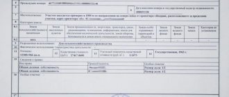
Any transactions with land require that the land plot be entered into the cadastral register. This is what the cadastral passport confirms. This is a fairly extensive document that consists of several parts. Contains a descriptive part that states:
- purpose of land;
- existing encumbrances;
- land area;
- permitted use;
- land plan;
- cadastral value.
That is, all information that exists in cadastral registration is indicated.
If a cadastral plan has been drawn up, do I also need to obtain a cadastral passport?
You can receive a cadastral passport. This is not necessary if a person simply owns a plot of land and does not intend to make any transactions with it. Essentially, a cadastral plan means the same thing as a cadastral passport.
It means that our land plot is already registered in the cadastral register. Therefore, it is not necessary to obtain a passport before making land transactions. And if a person plans to make any transactions with land, then it is better to obtain a cadastral passport. This will not be difficult if you have a cadastral plan.
In our opinion, obtaining a cadastral passport is not necessary, because today the functions of the authorities that carry out the registration of rights to real estate have been combined.
They also carry out cadastral registration. Therefore, the functions there are all combined and the very fact that the land plot already has a cadastral number and is registered will be enough to complete a real estate transaction.
What documents are required to obtain a cadastral passport?
This depends on whether this land plot is included in cadastral registration. We have 2 completely different mechanisms for obtaining this passport.
- If not included in cadastral registration
. This is a rather complicated situation, which is quite costly in terms of money and takes a lot of time. Why? Because a citizen who wants to enter his plot into cadastral registration must:
- determine it on the ground;
- carry out land surveying ;
- coordinate borders with neighbors;
- obtain a diagram of the land plot in relation to the cadastral urban plan of the entire area.
And only after that he can carry out cadastral registration. At the same time, land surveying, which is carried out by surveyors, is a rather expensive procedure (from 20,000 rubles) and takes more than 2 months. The period depends on how many geodetic companies work in a particular locality.
All other actions that we perform with administrative authorities also take from 20 to 30 days, so the procedure for obtaining such a cadastral passport takes several months.
- If the land plot is included in the cadastre .
In this case, a person simply applies for a cadastral passport. At the same time it provides:
- title documents for land;
- a site plan and a diagram of how its site is located on this cadastral plan.
The latter is also carried out by specialized organizations. After this, the person simply receives a cadastral passport. It is not difficult.
Today, basically, all land plots have already been taken into account. The only problem that arises is that the old plots that were once formed very often do not coincide and overlap with other land plots that are already included in the cadastral register.
In this regard, quite a lot of legal disputes arise, because it is difficult to determine the boundaries of a land plot. Especially in old settlements.
There are no problems with obtaining a cadastral passport itself. You just need to collect the necessary package of documents and contact Rosreestr to receive it.
Today, there are electronic resources and you can order a cadastral passport electronically. Therefore, if there are certain boundaries of the land plot and land surveying, obtaining a new cadastral passport is a completely simple procedure.
How to find out the cadastral number - a method for the “lazy”
We will tell you about 3 ways to do this completely free. 2 of them are elementary - if you have a certificate of registration of rights, or an extract from the Unified State Register of Real Estate. And the 3rd one is a special online service.
Let's start with the simplest. If you have a certificate of state registration of rights, then you can find the cadastral number directly on it.
We all know that property certificates have already stopped issuing. And now you can only get an extract from the Unified State Register of Real Estate. If you only have an extract, you can find the cadastral number in the first column of the extract itself.
And if you do not have either document, you need to use the Rosreestr website: rosreestr.gov.ru. At the very bottom of the page, select “Electronic Services”. Next, we need a section “Reference information on real estate objects online”.
After you go to the next page, you need to select the “Address” checkbox. Next, enter all the data regarding your property. Then below we enter the text from the picture, the so-called captcha, and click the “Generate request” button.
This page will show everything found related to this object. Including the cadastral number.
Is land surveying necessary if there is a cadastral number - you need to know
Recently, questions have often arisen about whether it is necessary to do land surveying if there is a cadastral number. Let's figure it out.
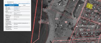
The presence of a cadastral number does not guarantee the presence of land surveying. What needs to be done? Go to the Rosreestr website and open a public map. Next, enter your cadastral number.
If the site has boundaries, that is, on the public map they are highlighted in red, and the site itself is highlighted in yellow, then in this case the survey was done earlier. And if the boundaries are not marked in red and the object is not located, then in this case your site is registered as previously taken into account.
That is, there are parameters of the site, types of permitted use, but there are no boundaries. In this case, you need to call a surveyor who will measure the site using a special device.
Next, the surveyor will transfer these measurements to the cadastral engineer, who will prepare an agreement with the neighbors. You will go to your neighbors with this act to sign. You sign the deed only with those neighbors whose plots have not previously had land surveying done.
After signing the act with the neighbors, the cadastral engineer will prepare a boundary plan. He writes the prepared boundary plan onto disk. Next, along with the acts, you submit this package of documents to the MFC. After 9 days, your boundaries will be determined.
What are the pros and cons of land surveying? The only negative is that it costs money. You won’t be able to do the surveying yourself, because you need special equipment. The surveyor who will take measurements must have the appropriate education. Calculations will also be required, that is, a cadastral engineer is needed. This is one of the minuses.
And now about the advantages. The first plus, the most important one, is that you will be able to manage your property (sell, give, inherit). Further, if there is a land survey, you will have the cadastral value correctly indicated. This will be important if you are selling a plot. That is, you will get more money in fact.
The third advantage is that the presence of land surveying allows you to pay real taxes, without overpayments. Fourth, without land surveying you will not be able to design your building. Fifth, having a land survey will allow you to avoid disputes and wars with your neighbors. If you have a land survey, then by law you have your territory (your site). There will be no disputes, no one will come and take your plot.
Well, the sixth plus, in our opinion, is the most important. When carrying out land surveying, you can legally and free of charge increase the area of your plot by 10%.
How to put a country house on the cadastre - the easy way
Registration of an individual residential building with state cadastral registration is carried out in relation to all residential buildings located on suburban land plots with the following types of permitted use:
- for individual housing construction;
- for running personal farming;
- for summer cottages intended for gardening.
This service may be required by all people who have unregistered residential buildings. Especially those who have just finished their construction. To register an individual residential building with the state cadastral register, the owner must contact a cadastral engineer to prepare a technical plan for the residential building.
The technical plan must include information about the coordinates of the characteristic points of the border of this house. High-precision satellite equipment is used to determine the coordinates of these points. When visiting the site, the cadastral engineer first of all determines the coordinates of the characteristic points of the outline of a residential building.
Then it measures the linear dimensions of parts of the room and determines the total area of this residential building. The total area is the main characteristic of an individual residential building. Based on the results of measurements, the customer of cadastral work receives a technical plan in electronic or paper form.
Next, the technical plan must be sent to the state registration authorities to register the house with the state cadastral register. The result of cadastral work is the receipt of an extract from the Unified State Register of Real Estate, which will indicate that the customer’s individual residential building is now registered.
Land supervision
Land supervision is the activity of officials to identify and prevent violations of land legislation. This function is assigned to Rosreestr employees.
During the service, a special profession was created and the position of state inspector for the use and protection of lands was established. He checks the activities of land owners and owners for:
- compliance with the intended purpose of land and use in accordance with permitted activities;
- compliance with the requirements for mandatory use of sites;
- unauthorized use of land plots;
- fulfilling duties to bring lands into proper condition;
- harm and pollution of land;
- execution of orders to eliminate violations of the law, and so on.
Supervision is carried out through scheduled and unscheduled inspections or systematic observation.
Based on the results, an inspection report is drawn up. If violations are recorded, the inspector issues an order to eliminate them.
Read more about the procedure in the material “State Land Supervision”.