When you need to buy a plot, people often encounter difficulties associated with the owner’s lack of desire to sell the plot. In addition, getting a plot from the state is much cheaper, because private owners may demand too high a price. But how do you know if a particular land is free? A public cadastral map will help you find out. It contains all the information on land plots in Russia. But how to find a vacant land plot on a public cadastral map?
Draw up a site plan.
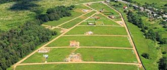
Running around the area and looking for free land for individual housing construction or private household plots is possible, but it is tiring.
At the same time, it is not a fact that the found land plot has not already been occupied by someone. In this case, you need to start the “running” again from the beginning.
And if you live in the North. And you want to move for permanent residence to warmer climes, for example, to the Krasnodar Territory. Then searching for free land in the area is even more difficult. You don’t have to fly on a plane every time to find a free area.
In this case it is reasonable
How to find a vacant land plot on a public cadastral map
One of the most convenient ways to search for vacant plots of land that can be purchased as property is to use the public cadastral map, which is located on the Rosreestr portal.
Information can be obtained in several ways.
In the card management section you should also find o. For convenience, consider the map functions in the section on land plots. In this search option, all free territories are marked on the screen with red geometric shapes.
How to check the cadastral number by address?
Where to find the urban zoning map, read here.
How to divide a plot of land, read the link:
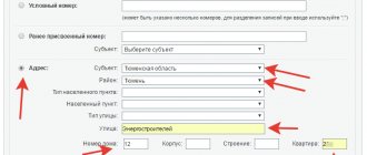
Another option is to follow a certain procedure:
- By moving the mouse over the map and changing the image scale, select the area of interest on the map by clicking the left mouse button once;
- After identifying the place of interest, select “Manage Map” in the map menu, then carefully look at all the inscriptions and find “Thematic Maps”. Select the item “Form of ownership of the memory”;
- After completing these steps, use the mouse wheel to zoom in as much as possible. This is done so that the territories of the land plots become visible on the screen;
- Please note that if the plot is displayed in pink, it means that this cadastral plot of land belongs to a specific owner;
- Next, examine the white areas of the map that may have this color for the following reasons: There is no new information regarding the indicated areas of land;
- In relation to the cadastral plot data, the property registration process is underway, but is not yet completed;
- Whether or not there are buildings on the site;
- The serial number of the plot when entered into the land cadastre;
If you have doubts about whether there are structures or structures on the territory of a plot of land, consider the selected area on satellite maps that can be found on the Internet, as close as possible. If objects are erected, they will be visible.
You can determine in advance the distance to the highway, to grocery stores, to the nearest settlement.
find a vacant lot online.
Using free online services, it is convenient to find vacant land plots.
For example, with the Public Cadastral Map and satellite maps of Google and Yandex, any area can be seen.
The surface of the earth is visible with an accuracy of several meters.
But the secret is not so much in finding land plots.
More valuable is the ability to use the Rules of land use and development of a populated area.
Rules (PZZ) help to specifically search for areas in zones that allow individual housing construction, private household plots, gardening or peasant farms.
Okay, we found a free plot of land. What to do next?
Next step -
How to find a vacant plot of land
At this level of provision of public services, there is nothing easier than finding out information about plots of land for which the owners have not yet been identified. To do this, you need to use the Rosreestr website, which hosts the PKK (Public Cadastral Map).
If a potential buyer of land has decided in advance about the area and area within which he wishes to purchase a plot, then it is necessary to use the information from the website of the administration of the settlement to which the plot belongs.
As a rule, data on plots that can be purchased for various purposes are generated and made publicly available on information portals of settlement administrations.
Participation in the acquisition of land plots owned by the state takes place through an auction, and only one applicant can become a participant in the auction.
Keep in mind that for a more detailed study of the proposed location of a plot of land, it is permissible to arrive at the administration of the locality responsible for the specified territory. If you appear in person, you can request a copy of the cadastral plan of the area under your jurisdiction on paper. Please note that for ease of working with papers, it is better to order a cadastral plan on a scale of 1:500.
Remember: if you need to purchase a plot of land within the territory of a settlement, then you need to look for information in the Land Use and Construction Rules. This document contains a map of the area planned for future development. Such rules can be obtained from the local administration or downloaded on the Internet.
After you receive a map of the settlement's development plan, find areas within the city where there are no buildings, but for which construction activity has already been permitted. It is these areas that are the most attractive in the future for the construction of residential premises for personal use.
In order to find out the location of plots of land ready for sale without leaving your home, you need to open a satellite map on the Internet and select a map service tool to determine the property owner.
draw up a site plan.
The layout of a land plot is the main document for obtaining land from the administration without an auction.
If the administration approves the site plan, then you receive the land without bidding.
Review of the Land Plot Scheme takes place within 30-60 days.
To draw up a site plan, most citizens invite a cadastral engineer.
For several thousand rubles, a cadastral engineer draws a diagram of a land plot.
Many people order a site plan from a cadastral engineer because they don’t know a simple secret.
How to register a vacant plot of land as your property
If you decide to register ownership of a property whose owner is absent, then be prepared for a lengthy and financially costly process. The most convenient way is to try to find the owners or persons who received a piece of land by inheritance, but have not formalized their right, and try to buy it.
Because if the site they own is not used, then most likely there is no need for it. For this purpose, submit a written application to find the owners of the land you are interested in to the local administration.
If, as a result of these actions, it was possible to find the owners of the property, then if they agree to transfer the site, formalize the purchase and sale transaction according to the standard scheme. If there is no response from the owners of the land, the procedure for legitimizing an ownerless plot will become more complicated.
To initiate this process, submit a statement of your intention to the territorial local government body. If you were looking for the owner of the site yourself, then attach to your application documents confirming these actions (requests to official authorities, registered letters with a return mark, etc.).
As part of your application, the ownerless plot will be registered with the cadastral authority. After this, the decision on your issue will be postponed for at least a year. This period of time is necessary for land owners (if any) to assert their rights. After this time (if the owner is not found), the case regarding the land plot is transferred to the court by the local authority.
To make a positive decision, it is necessary to provide significant evidence that there are no legal owners of the land (the land is not in use, the owners have not contacted them, what measures have been taken to find the owners). For the period of time required to wait for a response from the land owner, the local government body has the right to decide to lease the land plot.
Why is it wise to draw up a site plan yourself, rather than pay a cadastral engineer?
1. Because the preparation of a land plot diagram by a cadastral engineer does not guarantee receipt of the plot.
For example, you hired a good cadastral engineer.
We spent money on drawing up a site plan. And as a result, other characters may lay claim to the plot. And the administration will be forced to put the land up for auction.
In this case, you will be silently declared public gratitude. For spending money on a cadastral engineer. But no one will return the money.
2. It’s better to make a plot diagram yourself, because this allows you to start obtaining several plots at once.
Drawing up different schemes for several plots increases the chances of getting land.
After preliminary approval of the site, you can invite a cadastral engineer.
In other words, when there is an approved site plan, you can hire an engineer.
The approved scheme guarantees that the plot will be provided only to you.
Then you can easily hire a cadastral engineer to survey the site and register it.
Until the administration has approved the land plot plan, spending money on a cadastral engineer is pointless.
Indicators of a public cadastral map
Of course, the main assistants in finding vacant land are cadastral map tools, or rather indicators that provide certain information about the territory. In order to determine the permitted type of land use, you need to turn on thematic highlighting of the map. There, lands with each type of permitted use will be painted in one color.
This will help you decide in which zone to start searching, based on the purposes for which the site is needed. Thus, private individuals can only claim land for individual housing construction or agricultural land. Other categories cannot be transferred to private ownership. They can only be rented.
Another useful indicator is the quarterly plan for land surveying and delimitation of individual areas. The current realities are such that the demarcated areas have most likely already found their owners. And the areas that are free were not surveyed.
We recommend that you read:
Purchasing land from the state
As a general rule, the surveying of vacant lands and their cadastral registration is the function of local governments. However, the land surveying procedure requires the participation of cadastral engineers, whose services are not cheap. For this reason, almost the entire mass of land in municipal ownership does not have definite boundaries.
But in some localities, where the government takes a responsible approach to its task, vacant land holdings can be demarcated and registered in the cadastral register. In this case, it will be impossible to find out whether the land is free. Indeed, in any case, the cadastral map will provide information about the registered property rights. To obtain detailed information about the form of ownership, you must order a paid cadastral extract.
How to find vacant land and draw up a site plan?
The transition from fruitless thoughts to practical steps to obtain a plot of land will be facilitated by step-by-step video instructions.
The instructions show in detail the algorithm of actions that anyone can easily repeat.
Watch the video instructions and follow the step-by-step steps.
You will understand that the “extreme difficulty” of obtaining land that realtors talk about is just a clever ploy. Pseudo-specialists are accustomed to profiting from the ignorance of citizens.
How to find a plot for individual housing construction
According to the norms of the current legislation, the provision of land plots is of a declarative nature.
In accordance with the Law of the Kemerovo Region dated December 22, 2014 No. 128-OZ “On assigning the authority to dispose of land plots, state ownership of which is not delimited, in the urban district - the city of Kemerovo to the powers of a special executive body of the Kemerovo Region, exercising certain powers in the field land relations”, the management of land plots, state ownership of which is not demarcated, in the urban district - the city of Kemerovo is carried out by the Committee for State Property Management of the Kemerovo Region (KUGI KO, Kemerovo, Sovetsky Ave., 58, t. 58-11-94) .
Currently, the Kemerovo city administration does not have information about land plots free from third party rights and capital construction projects intended for “spot” individual housing construction.
For the purpose of comprehensive development of individual housing construction, the administration of the city of Kemerovo decided to develop documentation for the planning of a number of territories in the city of Kemerovo.
The provision of land plots developed for individual housing construction will become possible after the approval of documentation on planning and land surveying.
According to Art. 46 of the Town Planning Code of the Russian Federation, approved documentation on territory planning (territory planning projects and territory surveying projects) is subject to publication in the manner established for the official publication of municipal legal acts, other official information, within seven days from the date of approval of the said documentation and is posted on the official website municipal formation www.kemerovo.ru on the Internet, on the portal for supporting urban planning activities www.mgis42.ru, and is also published in the official source of publication of legal acts of the city of Kemerovo - the city newspaper "Kemerovo".
In accordance with the resolution of the Kemerovo city administration dated 02/06/2015 No. 224, for which planning documentation is being developed - the territory is within the boundaries of: st. Holy spring - railway - border of the municipality city of Kemerovo - st. Dekabrskaya in the Rudnichny district of the city of Kemerovo.
The approximate deadline for the development and approval of documentation for the planning of this territory is the 1st quarter of 2021.
If the plots offered on the website do not interest you, you have the right to independently find a free (empty) plot of land intended for the chosen purpose and submit an appropriate application.
Thus, you have the right to contact KUGI KO with an application for the provision of a land plot in the manner prescribed by current legislation. The application form of the established form and the list of required documents, methods for submitting applications and flowcharts explaining the procedure for providing land plots can be found on the committee’s website www.kugi42.ru in the “provision of land plots” section, as well as on the main page.
You can submit an application for obtaining a land plot through the MAU "MFC Kemerovo" (Kirova St., 41a, t. 77-21-76, Recordnaya St., 2v, t. 77-47-99, Pionersky Boulevard, bldg. 3, room 1, t. 44-49-99), Property Fund of the Kemerovo Region "Kuzbassfond" (90/2 Lenina Ave., t. 35-86-75), Federal State Unitary Enterprise "Russian Post".
What documents are needed to obtain ownership of a vacant plot of land?
If the administration agreed to meet you and formalized the contractual relationship for the use of the site, then for the further procedure for legitimizing the land, collect the following documents:
- an official request to transfer the plot of land under ownership;
- a certificate from the BTI on the characteristics of the site;
- cadastral plan compiled on the basis of information from a geodetic organization;
- a document permitting limited use of land;
- cadastral registration passport.
The legislation provides a period of at least 90 days for consideration of the above documents. If, as a result of the inspection, a positive decision is made, then buy the land plot on the terms proposed by the government agency. As a rule, in this case the average market value of land is taken into account.
The next, no less important stage will be the land surveying. For this purpose, contact a geodetic company. After receiving the boundary plan, provide all available documents for the land to the state real estate registration authority.
How to find a vacant land plot on a cadastral map?
How to find out information about a property through Rosreestr, read here.
For a sample purchase and sale agreement for a garden plot, see the link:
To legitimize the site, submit the following documents to the territorial body of Rosreestr:
- permission from the administration to transfer land into ownership;
- cadastral registration plan;
- land survey plan;
- receipt of paid state duty (the amount of state duty is 2 thousand rubles);
- a land purchase agreement concluded with a municipal authority.
After accepting the documents, the Rosreestr service employee issues a receipt indicating their receipt indicating the date of readiness of the property document.