When checking cadastral documentation, you may encounter a situation where the actual area of a plot differs from the size of the territory recorded in the document. In order to register additional square meters of land as a property, it is necessary to prepare all documents correctly, avoiding erroneous actions.
Reasons for the discrepancy between the area of the land plot in fact and in documents
Many land owners, after drawing up land documents or receiving them during a land purchase and sale transaction, do not check the compliance of these documents with the actual boundaries of the land plot.
The most common reason for such a discrepancy in data is that when registering the land surveying procedure and drawing up the cadastral passport, the cadastral engineer made a mistake when measuring or entering data into the documents.
It is most likely that this situation arises in relation to plots of land that were demarcated earlier, since previously specialists did not have an accurate measurement tool when carrying out work to demarcate plots of land.
This led to the fact that the calculated footage of the site in the document did not coincide with the real data obtained later when using more advanced and accurate equipment.
Often, such discrepancies between the actual measurements of a plot of land and the data in the cadastral passport appear due to unauthorized changes in the boundaries of the plot by the owners by seizing the neighboring territory.
Sometimes situations are complex, since the size of actual ownership is several times greater than the amount of land in the documents. In order to retain the rights to use the entire area of the site, it is necessary to formalize the difference in the area of the territory in a certain way.
Be aware that it is necessary to inquire about whether the data on the boundaries of the land owned by the owner is entered into the land registry. If there is no data in the cadastre, then you can safely register the seized land as your property.
In fact, the main reason for the discrepancy between the data in the documents and the actual size of the plot is the lack of land surveying. Since it is through land surveying that the land owner can be sure of receiving accurate data on the size of his own plot of land. In addition, the owner of the territory, after surveying, receives the exact coordinates of the location of his site.
Be aware that some citizens can register ownership of land that is not listed as the owner according to documents:
- Citizens and their heirs who acquired land for use during the USSR;
- Citizens who acquired land before October 30, 2001.
Since until this moment there was no Land Code of the Russian Federation and rules governing land registration, owners of such plots can count on easy acquisition and registration of rights to additional acres of land.
Land plots: how to legalize “extra” meters
October 1, 2021, 20:04 - Public news service - OSN The problem of the discrepancy between the actual boundaries of gardeners' land plots and the boundaries indicated in the documents is as old as the world. The right to legalize cuttings is indicated in the Land Code. But until recently, turning the right into reality was too expensive and troublesome. The new federal law makes it possible to legalize “extra” meters. The head of the public reception of the Union of Gardeners of Russia, Lyudmila Buryakova, told the Public News Service about how to do this.
“Federal Law No. 150-FZ “On Amendments to the Federal Law “On Cadastral Activities” and the Federal Law “On State Registration of Real Estate” makes it possible to minimize the costs and time for legalizing additions, as well as for correcting registry errors,” the expert explained.
Where do the cuttings come from?
Sometimes it happens that in fact the area of the plot is larger than in the documents. Sometimes the owner of the land may not know that instead of the standard 6 acres, he owns a plot several tens of meters larger. The discrepancy may become clear when a person decides to register the site with the cadastral register. And it turns out that the error crept in 20 years ago when measuring the land. These “extra” meters can now be easily privatized.
– It happens that a gardener decides to landscape a neighboring empty plot. The neighbor's fence is two meters away, there is no road here, this is not a street or an alley, a small wasteland in a word. And for eighteen years now he has been growing carrots and radishes in no-man’s land. The neighbors don't make any comments, he doesn't bother anyone. But the land is in fact not his. A person wants to officially make the land his own, which is now an absolutely real story,” said Buryakova.
Why is this real now?
The solution is facilitated by comprehensive cadastral work, the procedure for which is simplified.
– Complex cadastral work is an inventory of land carried out by the state in the interests of the state in order to clarify boundaries. The entire territory of Russia is divided into cadastral blocks. Geodetic surveys are being carried out, which immediately cover all land plots, buildings, and structures inside the cadastral quarter. The results are immediately transferred to the Rose Register database. – the expert explained.
At the same time, border inconsistencies (crossings), self-captures, and registry errors are quickly identified. And violations, voluntary and involuntary, including short cuts, must be corrected, Buryakova noted.
How to add meters to yourself
To legitimize the actually used “extra” meters, three components must be met: the site has been used within these boundaries for more than 15 years; neighbors do not claim it; The authorities have no complaints.
– And then we look at regional legislation, which reflects the maximum area of a land plot and the conditions for legitimizing “extra” land. For example, in the Moscow region, up to 10% of the area of a land plot indicated in the Unified State Register can be legalized for free, the rest can be purchased for 50% of the cadastral value of a given land plot,” Buryakova continued.
The situation with allowances is discussed at the next general meeting, that is, as usual.
If there is excess area within the boundaries of the site, you must contact the cadastral engineer with a request to carry out land surveying. And then you can contact the MFC with a statement of desire to legalize the actual area. It will be necessary to provide photographs of the site taken by a cadastral engineer and minutes of the general meeting on this issue.
“For the procedure for legitimizing extra meters, other documents will be needed, but government agencies will find them without your participation through information interaction,” added the representative of the Union of Gardeners.
In the same way, you can make a neighboring plot of land yours. Only in this case, the cadastral engineer must make a separate survey of the site and the territory that you want to legalize. And then with a copy of the survey of the site and the minutes of the general meeting on this issue, we contact the MFC.
Previously, we reported that the Federal Tax Service updated data on plots for calculating land tax.
What to do if the area of the plot is larger than according to the documents
If it turns out that the area of the plot in fact greatly exceeds the size of the land according to the documents, then first of all obtain a certificate from the cadastral service regarding the plots of your neighbors. If there is no land surveying plan, such data will be useful.
To obtain this information, go to your local cadastral commission or land committee. Before doing this, make inquiries about the owners of adjacent lands to be sure that they have no claims regarding the seizure of their territory.
To claim land, find out the following:
- No land surveying was carried out in this area;
- The owner of the land has not been found, information about such a person is not available in open sources;
- The land plot is not leased by the settlement administration;
- There is no auction being held for the site, and there are no applications for its acquisition.
If the above points are met, then you need to hurry up with the registration of the current boundaries of the site. To do this, you need to fill out an application for work to be carried out by a cadastral engineer in the administration or land services existing under the administration of the settlement.
Make sure that the specialist you choose to carry out geodetic work has the appropriate license and can carry out land surveying work.
Please be aware that it is not necessary to clarify the boundaries of land for which there are already entries in the register. After all the necessary measures have been completed, the cadastral engineer will issue the customer with a boundary plan for the plot of land that needs to be annexed.
With this document, go to the cadastral chamber to enter new data into a special register that takes into account all changes in relation to plots of land. However, when submitting a boundary plan to register new boundaries after they have been clarified, complications may arise.
The following points may be the reason for refusal to register new borders:
- If the area of the plot of land that a citizen wishes to annex to his own plot exceeds the size of his plot by 10% or more;
- The plot of territory that needs to be annexed must comply with the minimum and maximum permitted dimensions of the plot area in accordance with the standards established in each subject of Russia or in each municipality.
If the registration of the size of the plot was successful, obtain a cadastral passport and go to the state registration authorities for real estate rights. The result of the actions is the receipt of a document on registration of ownership of the territory with boundaries that are officially clarified.
Solving the problem, drawing up an approval act
And now the cadastral engineer has completed his work and notifies the parties about the presence of displacement, overlap, intersection, etc. regarding data in official documents.
In the vast majority of cases, the situation can be resolved quite peacefully. To do this, you need to come to an agreement on how the outlines of the boundaries of the two neighboring plots will change. Or leave everything extra to your neighbor.
Attention! The key importance here is not only the good will of the parties, but also the maximum permissible (maximum and minimum) sizes of plots in accordance with the purpose of the land plot. That is, even with the consent of neighbors, these restrictions must be taken into account. If the neighbor does not argue with the changed location of the fence, then Rosreestr will always take into account the provisions of the law.
If all the above conditions are met, then an approval act is drawn up to formalize the mutual overlap of allotments.
Further, the new legislation provides for the signing of an agreement on land redistribution.
The parties to the agreement are required to submit a corresponding application to the authorized body.
The application shall indicate:
- last name, first name and patronymic of the applicants,
- location,
- passport details,
- cadastral numbers of plots subject to redistribution,
- land surveying project data,
- contact information for communication with citizens participating in the transaction.
The following are attached to the application:
- documents confirming the rights of the parties to the plots,
- territorial location diagram (if available),
- confirmation of the authority of the representative (if the issue is resolved with the help of such an assistant),
- certified translation into Russian of all submitted documents (if the applicant is a foreign person),
- passports of the parties.
Citizens can forward all of the above to the authorized organization in person, via Russian Post, or in the form of electronic documents using the Internet.
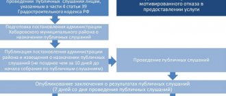
Within ten days, the submitted application may be returned without consideration if it does not meet the established requirements.
Also, within a period of no more than thirty days, based on the results of the consideration, a verdict is issued:
- make a decision and approve the scheme and issue this decision to the parties,
- provide consent to conclude the relevant agreement on the land surveying project,
- decision on refusal, which must be motivated, indicating the rules of law, and explanations.
Conditions for registering additional land for your plot
Know that when realizing the desire to add additional land to an existing plot, you need to enlist the support of your neighbors. Since if any neighbor does not agree with the boundary plan, it will not be possible to register additional acres as property. Please note that by annexing a territory, you must not interfere with your neighbors’ use of their own plots.
Take into account the data of Federal Law No. 221, which specifies the maximum permissible size of the territory to be annexed to an existing land plot. In this case, take into account the characteristics of the region or municipality to which the land belongs.
However, keep in mind that if there are complications or obstacles when registering ownership of additional acres of land, it is permissible to go to court if this will help achieve the goal.
How to register extra acres for a plot of land
Understand that it is necessary to register extra acres that are not taken into account in the title documents, since the exploitation of land resources for profit and the results of business activities is a crime.
To legalize the use of someone else's land, it is necessary to carry out boundary work again, if it took place previously, clarify the boundaries of the territory and register them by preparing certain documents.
Follow these steps:
- Invite a specialist who can record the exact position of the current boundaries of the site;
- Then receive the result in writing after carrying out the boundary work, pick up the technical documentation, check the information indicated in these documents about the actual size of the land plot;
- Having received the land survey plan, draw up again a document with the written consent of each owner of the plot that has common boundaries with the plot being designed;
- Submit all documents that you have on hand regarding the plot of land to the administration with an appeal in which you accurately and in detail outline the version of the appearance of ownerless land near your own plot;
- Please know that if you have a certificate of registration of ownership rights in relation to the previous plot of land before the annexation, re-register it;
- To re-register, you must have in your hands an agreement for the acquisition of a land plot, a document confirming the right to inherit the plot, or a gift agreement;
- If the specified documents are not available, study the data of Federal Law No. 93 and register ownership of the plot, to do this, provide an extract from the garden or dacha partnership about the allocation of a plot of land on a general basis as a member of the partnership;
- If there are papers on the basis of which it can be concluded that land has been received from local government on a leasehold basis, then submit these documents;
- Having collected all the necessary papers, transfer them to the FUGRTs to receive a document of ownership of the plot with real boundaries and area.
The act of agreeing on the boundaries of a land plot with neighbors.
Read about coordinating the boundaries of a land plot with your neighbors here.
What to do when imposing boundaries of land plots, read the link:
How to draw up an act of coordination of the boundaries of a land plot with neighbors
In order to claim additional meters of land, it is necessary to follow the procedure for drawing up an act of coordination of boundaries with neighbors, which sometimes becomes an unsolvable problem in the process of registering a land plot.
Study the rules for drawing up an approval act:
- Personal data of the parties to the agreement, while the presence of each neighbor whose land borders the disputed territory is required;
- Make copies of their identification documents;
- The final document on the approval of boundaries, which must be recorded on the boundary plan, on the back you must write the coordinates of the final version of the location of the boundaries of the site; it is better to supplement the document with a schematic representation of the boundaries of the site;
- If there are opponents to the concluded agreement, it is necessary to attach written objections, on the basis of which it is impossible to agree on the act being drawn up;
- Signature of each participant in the agreement if he agrees with the information and results of the revision of the boundaries of the site;
- A stamp with a transcript of the name of the surveyor and his stamp on the document.
What to do when reducing area
Reducing the area of land is possible in two cases :
- When correcting a cadastral error. Moreover, according to Order of the Ministry of Economic Development No. 943 of 2015, the initiative to correct a cadastral error can come not only from the owner of the plot, but also from Rosreestr.
- When a claim arises from neighbors who carried out land surveying, according to the results of which the border of their site runs along an adjacent plot.
This is interesting: How to remove a kiosk from the local area
In any of these cases, the site owner has 2 ways to solve the problem:
- Agree with the reduction of land and sign the deed of approval of boundaries.
- Do not agree with the reduction and order clarification of the boundaries of the land plot.
If the clarification procedure does not give the desired result, you can file a claim in a court of general jurisdiction , which will appoint a judicial land management examination.
Documents for registration of land acquisition
Remember that in order to formalize the acquisition of plots of land that do not belong to the owner, the latter will need to prepare and submit the following papers:
- A contract for the sale and purchase of a plot of land, papers on the rights of inheritance of the plot by the owner, documents on receiving the plot as a gift from the owner of the land, in this case, proof of ownership for the donor is needed;
- A written version of the existence of land without an owner, set out in as much detail as possible;
- Permission from local authorities to transfer land to a new owner;
- Cadastral documentation;
- A document confirming the registration of a plot of land with new boundaries as the property of the owner.
The listed papers must be submitted to representatives of the settlement administration who deal with land issues, attaching a statement about the need to change the data in the Unified State Register.
Legal grounds for changing the area
There are a number of legal grounds, upon the occurrence of which the actual area of the land plot can be increased compared to that which was previously indicated in the cadastral documents for the land.
These legal grounds include:
- Increasing the land allotment at the expense of land in state or municipal ownership , as defined by Article 39.28 of the Land Code of the Russian Federation. In this case, the formation of stripes is not allowed. That is, you can increase your own allotment only at the expense of adjacent state land.
- Correction of cadastral error. If earlier, during land surveying, a cadastral engineer made an error that led to a decrease in the area of the site, then this error can subsequently be corrected, which will lead to an increase in the area.
- Acquisition of land from a private individual on the basis of a purchase and sale agreement. As in the case of increasing a plot at the expense of state land, the acquired plot must have adjacent boundaries with the enlarged plot.
- Permissible excess of allotment . Subclause 32 of clause 1 of Article 26 of Federal Law No. 218 of 2015 determined that when carrying out land surveying, a plot can be increased by a certain amount (see below), if this does not lead to the imposition of boundaries on adjacent plots, public lands, etc.
Application for amendments to the Unified State Register of Real Estate
The order of the Federal Tax Service of the Russian Federation No. ММВ-7-6/25 defines the type of filing an application; the document must contain 2 sections:
- Indicate the essence of the changes being made, here it must be written that it is necessary to clarify the boundaries of the land plot in order to calculate the actual area of the land plot in use by the land owner;
- In this section, you need to set out in detail but concisely the reasons for making amendments to the document.
Check that after the document the date of writing this paper is indicated and there is a personal signature of the compiler with a transcript of the surname.
How to formalize the actual boundaries of a land plot through court
Know that by law you can annex a territory that is no more than 10% of the size of the current plot of land. However, if the annexed plot is disproportionately larger than the current one, and the land is owned by the municipality, you can try to register the land on the basis of the actual long-term continuous use of the territory for personal needs.
Please note that such a right to expand the site at the expense of the city will have to be proven in court. According to lawyers, in such cases the court usually makes a decision in favor of the land owner, who fully complies with the rules for the exploitation of land resources. The fact of ownership and use of a plot of land for 15 years will greatly facilitate the decision for the court.
To competently draw up a claim and speak in court, follow the following rules:
- File a claim to establish the boundaries of the site in court;
- Make inquiries in advance about all citizens who may be interested parties in the claim, make inquiries about third parties who may be witnesses or other citizens;
- Be sure to indicate in the claim the exact coordinates of the boundaries of the site, which must be preserved by court decision, and attach to the claim a boundary plan drawn up by an engineer in the form of a copy;
- If there is data on the geographical location of the site, present it to the court in an accessible form; if there is no data, write an appeal to the court in the form of a petition to make inquiries and provide the court with materials confirming the position of the site on the map of the area;
- Find out in advance how to declare the need for an examination of a piece of land;
- After receiving the data from the land management examination, adjust the claims to the court.
The data in the boundary plan may not coincide with the results of the examination. Use expert evidence to increase your chance of a positive trial outcome.
If you accept the expert’s data as the basis for drawing up a claim, do not forget to compare the claim with the results of the examination, and, if necessary, correct the requirements in the introductory part of the claim.
Instead of a conclusion, or Putin’s opinion on the addition of a plot of land
Vladimir Putin allowed Russians to register surplus land. This benefits both the state and the ordinary citizen. By signing 150-FZ dated June 17, 2019 (the law came into force on September 16, 2019), the president thereby expressed his opinion on the appropriation of land plots and confirmed the need to simplify cadastral work, which, according to the deputy head of the cadastral chamber, Marina Semenova, will have a positive impact on land owners. The registered plots will now officially be the property of citizens - which will increase revenues to the treasury through land taxes, and citizens, in turn, will be able to own plots not only in kind, but also legally.
Difficulties when the actual area of the plot differs from the documents
There are two reasons why registration of excess land area as a property may not take place:
- Free land registration applies only to plots that meet the maximum minimum size of the territory when allocated. In this case, we are talking about the fact that if there is a minimum plot size in the region, for example, 8 acres, when adding additional land you cannot get more than 8 acres; if there are no certain minimums in the region, then the additional area is calculated in the amount of 10% of the area plot recorded in cadastral documentation;
- When carrying out boundary work, the cadastral engineer is obliged to indicate the reason for the increase in the area of the site. In this case, the fact of owning land for a period of more than 15 years is most often used, in addition, the presence of natural or other objects that make it possible to fix a more accurate position of the boundaries of the site and form coordinates for the location of new boundaries.
What to do if the size of the plot increases?
The above legal grounds for increasing the area of a land plot can be divided into 2 categories :
- Which do not require additional registration of land ownership. This is the correction of a cadastral error and the permissible excess of the allotment.
- Which require additional registration of land ownership. This is an increase in allotment due to adjacent plots that are in state ownership or in the possession of another private person.
In any case, an increase in the area of the allotment is not allowed if such an increase occurs due to:
- Public lands (for example, roads);
- Plots belonging to other categories (for example, the main plot lies in the lands of settlements, and the cut-off part lies in agricultural lands).
It is not allowed to increase the land plot if this exceeds the maximum plot size established at the legislative level in a particular region.
Without registration of land ownership
Correcting a cadastral error implies clarifying the boundaries of the land plot. If it is revealed that a cadastral error actually occurred, the plot will be registered in accordance with the newly established boundaries, regardless of how much its area has increased.
The situation with the permissible excess of allotment is much more complicated. Subclause 32 of clause 1 of Article 26 of the Federal Law No. 218 of 2015 established that when carrying out land surveying, the area of the plot can be increased in comparison with that indicated in the original cadastral documents, but not more than by a certain amount .
The same subclause established that the limiting value for increasing the allotment is the minimum size of the plot for a given type of intended use, fixed at the legislative level.
That is, if a local (adopted at the regional, regional, city level) regulatory act establishes that the size of the plot for individual housing construction
cannot be less than 3 acres , then the limit for increasing the interconnected plot of individual housing construction is also 3 acres.
For example, if the documents initially indicated the area of the allotment for individual housing construction as 10 acres, then after land surveying it cannot exceed 13 acres.
The same subclause determined that if the minimum size of a plot for a given type of intended use is not determined, then the limit for increasing the boundary plot is 10% of the original size .
That is, if the documents initially indicated a plot area of 10 acres, then after land surveying it cannot exceed 11 acres.
With registration
If the owner of an allotment has acquired an adjacent plot from his neighbor, he can combine the land into one allotment, provided that the resulting land plot will not exceed the maximum size of the land plot established in the region.
To increase your plot at the expense of land belonging to a neighbor, you must first purchase it .
Clause 2 of Article 39.28 of the Land Code of the Russian Federation determined that if the owner of the land wants to increase his plot at the expense of land owned by the state, he needs to enter into an appropriate agreement with representatives of the local administration, for which a certain fee will be taken from him.
Essentially, in order to legitimize an unreasonable increase in land allotment, the owner of the plot must purchase part of the land either from his neighbor or from the state.