Home » Land disputes » How to survey a land plot in shared ownership
6
In some cases, owners of a common plot of land are faced with the need to divide it. survey land plots, come to the aid of the owners . This is done so that each of the owners can determine the boundaries of their particular part, as well as assign it an individual cadastral number and a unique address. So how is land surveyed when owned by 2 or more persons?
Land surveying goals: why is it necessary?
When it comes to common shared ownership, it is more legitimate to speak not about land surveying, but about the delimitation of land. Land surveying is a procedure during which the exact boundaries of a land plot are determined and a detailed description of its characteristic features is formed. In turn, the main purpose of demarcating a site is to divide it into several parts , with each of which it will subsequently be possible to carry out separate legal operations (transactions).
So, after demarcation, each of the parts of the once common allotment can:
- transfer to another owner by donation;
- change hands by sale;
- move to another owner in the process of dividing property (for example, during the divorce of former spouses);
- change your target purpose, etc.
The boundaries of the main area within which the demarcation is carried out remain unchanged. The allocation of parts occurs on the basis of those parameters that are indicated in official documents on the right to own shares of a plot . At the same time, engineers carrying out land surveying may deviate slightly from the given values, because they need to take into account the properties and characteristics of the soil.
How is the demarcation between two owners and the delineation of shares of a land plot carried out?
The first stage of demarcation is drawing up an agreement on the division of property. Such a clause must be present only in situations where the owners of individual shares of the plot will be different entities or persons .
- If there is a need to sell part of one plot owned by the owner;
- If it is necessary to divide property , when such measures take place during the divorce of spouses and the division of property that belongs to jointly acquired property. Moreover, most often such measures are applied to those areas that do not yet have buildings on their territory.
We recommend reading: How many square meters per person?
The procedure for marking the territory
First, the person who undertakes the division of the plot will need to obtain permission to carry out engineering work and to “split” the total land area. The voluntary consent of all subjects interested in the matter is a prerequisite for land surveying.
The citizen will have to notify co-owners and neighbors in advance about the start of the process. This must be done no later than 1 month before officially contacting the geodetic company.
If one or more share owners do not agree to divide the plot, the conflict can be resolved in court. The choice of instance will depend on the cost of the claim. If it does not exceed 50,000 rubles. , then you will need to go to the world court . If the claim price is over 50,000 rubles. you need to go to the district court .
How is an agreement between shared owners drawn up?
The consent of the share owners must be legally recorded. The document is drawn up in writing and secured by the signatures of all persons who own the common land plot. Here it will be necessary to reflect that the decision to demarcate the site was made on a voluntary and mutual basis.
The agreement specifies the following information:
- date and place of drawing up the paper;
- listing of all participating entities (full name, date of birth, passport details, registration addresses);
- description of the original public object (land plot indicating its cadastral number, address, area and purpose);
- the main provisions of the agreement being concluded (an agreement on the division of a land plot, transfer of shares, a clause on changing ownership, the procedure for covering expenses, etc.);
- signatures of the parties.
The agreement does not need to be certified by a notary - it takes full legal force from the moment it is signed. However, the parties will need to ensure that the agreement indicates the fact of termination of the right of shared ownership - otherwise, even after the delimitation and division of the land, the new plots will also become common and not individual property.
Determination of shares and areas: how much and for whom
It should be remembered that the work may be useless and ineffective. This will happen if there is not enough land area for each potentially individual owner. This rule is enshrined in Art. 4 of Federal Law No. 101-FZ. For each subject and region, the maximum (maximum and minimum) values of land area per owner will be different. A person can obtain the most up-to-date information based on local urban planning regulations from the administration at his place of residence.
In other words, if after surveying it turns out that the allocated land does not meet the minimum area indicator, the state body will refuse the applicant to register the property right and register it in the cadastral register. At the same time, it will be impossible to hold accountable the engineers who allegedly should have determined the insufficiency of the territory. Specialists are called upon to provide surveying services at the request of the customer, but are not obliged to advise him on various legal issues.
Since the interim area is calculated in proportion to the available shares, participants in the process will need to refer to a previously drawn up contract for the sale and purchase of a land plot (or any other document of title). Usually this is where it is indicated what share is assigned to each of the owners. If there is no provision on the division of shares, then in accordance with Art. 245 of the Civil Code of the Russian Federation, the shares of owners are recognized as equal.
Interested parties have the right not to take into account the size of shares that were specified in the purchase and sale agreement or other title document. They can voluntarily agree to divide the plot in other, arbitrary proportions.
Choosing a cadastral engineer
The choice of a contractor who will demarcate the common territory falls entirely on the shoulders of the owners themselves. Therefore, it is so important not to make a mistake and choose a responsible surveyor. A specialist of this type can act on behalf of an individual entrepreneur or a law firm with which he has an employment contract. To protect yourself from possible unprofessionalism, a person can check the cadastral engineer and/or his company as follows:
| Action | Description |
| Obtain information from the state register of cadastral engineers located on the official website of Rosreestr. | Here we collect data on all Russian specialists who currently have accreditation to carry out specialized work. |
| Request a license from the surveyor allowing him to carry out land surveying. | The customer should request the presentation of this document at the stage when the contract for the provision of services with the contractor will be concluded. |
| Read personal reviews from other customers. | Similar reviews are presented in large numbers on the Internet. |
The final cost of land surveying is always individual and depends on many factors. For example, in Moscow you will have to pay about 100,000 rubles , while in small cities the price will be significantly less. The cost decreases proportionally depending on the size of the intervening area - the smaller it is, the lower the price. That is why defining the boundaries of only 1 share will cost less than defining the boundaries of, for example, 5 shares of the original allotment at once.
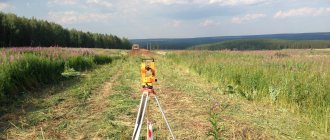
Surveying work: process
Carrying out boundary work begins with the surveyor asking the customer for comprehensive information about the land plot. The following indicators are important for an engineer:
- The size of the plot to be surveyed.
- Status of the land on which the site is located.
- Status of the locality (city, town, etc.).
- Purpose of land, etc.
Next, the specialist conducts a geodetic survey of the boundary area and correlates all the data at his disposal: the boundaries of the main site, its turning points, distinctive features of the landscape, coordinates of new boundaries based on the shares or personal wishes of the owners. If any provisions raise doubts and questions among the surveyor himself or the owners, additional calculations are carried out.
It is necessary that each allocated area meets the following requirements:
- It had access to a public road.
- It was the right shape.
- Did not intersect with neighboring plots (including the territory/territories of former co-owners).
Only after an exhaustive analysis of all the data, the engineer draws up a boundary plan and also goes to the location of the land to establish new boundaries in kind (place boundary signs) and obtain signatures from all interested parties. Usually the work process takes up to 2-3 weeks.
How land boundaries are surveyed - documents, terms, cost
Most often, land surveying is ordered to establish the boundaries of a site and enter them into the real estate cadastre. In this case, the cadastral engineer will compare the coordinates of the actual boundaries of the site with those boundaries indicated on the plan of the title document (document on the fact of the formation of the site). If the actual boundaries of the site differ greatly from the boundaries indicated in the plan, then the cadastral engineer will draw up a written conclusion about the impossibility of drawing up a boundary plan. In practice, the error is set at 10%.
We recommend reading: What are the encumbrances on an apartment?
Also, when setting boundaries, the cadastral engineer coordinates land surveying with the owners of neighboring plots. It is necessary to coordinate land surveying with the owners of only those plots with which → 1) there are common boundaries → 2) the neighboring plot has boundaries established in the cadastre → 3) the neighbors have a title document for the plot - clauses 1 and 3 of Art. 39 of the Law on Cadastral Activities.
Registering a new address
The person who initiates the demarcation process (i.e. the customer of geodetic work) actually becomes the legal owner of the new land plot . He automatically ceases to be a shared owner and becomes an individual owner.
The new plot will need to be assigned a separate address. To do this, the individual owner will need to contact the local municipal service in person or through his representative (if he has a notarized power of attorney). An application containing the following information must be submitted here:
- Full name and position of the recipient employee;
- Full name, residential address and contact telephone number of the applicant;
- request to assign an address to the land plot;
- list of attached documents;
- date of compilation and signature.
The application will need to be supplemented with copies of procedural materials - these are:
- the applicant's civil passport;
- boundary plan;
- an extract from Rosreestr containing a description of the original plot and an indication of its owners;
- an agreement between shareholders or a court order on the delimitation of land and division of the allotment.
Assigning an address to a land plot is a procedure that is not subject to state duty. The period for consideration of the submitted application should not exceed 18 days.
Registration of ownership
The individual owner will be required to formalize the right of land ownership and register the land in the cadastral register . Registration of property rights is carried out at the local branch of Rosreestr, at the MFC, as well as on the State Services portal or on the Rosreestr portal. Regardless of what form (paper or electronic) the application will be drawn up, the following information will need to be reflected here:
- type and characteristics of the object;
- personal information about the copyright holder;
- the basis for the emergence of property rights;
- an indication of the method of submitting documents, a list of them (an agreement of the former owners of the original plot or a court order to carry out demarcation, a land survey plan, an act on the installation of boundary signs, an act of coordination of boundaries with neighbors, a receipt for payment of the state duty established in Article 333.33 of the Tax Code of the Russian Federation) ;
- indication of how to receive a response;
- date of completion and signature of the applicant (future owner) with a full transcript.
The period for consideration of the submitted application should not exceed 10 days. The remaining share owners (if any) will also need to contact Rosreestr and provide employees with information about their actually a new site. Otherwise, information about the land remaining in their use may be deleted from the unified database, because By law, after division, the original plot is considered to no longer exist.
Example
In practice, land owners turn to land surveying services quite often. Thanks to this procedure, owners have the opportunity to individually and freely own, use and dispose of their property within the framework of current legislation.
Example. Citizen N. and citizen A. entered into a voluntary agreement to survey a common plot of land and to divide it. According to the purchase and sale agreement, the man's share was 1/3 of the entire plot, and the woman's share was 2/3. The owners invited an accredited specialist to carry out survey work, who completed the task in accordance with the standards.
Thus, 2 newly formed areas met the established regional standards - in terms of their area, they turned out to be no less and no more than the boundaries that were defined in the subject for lands of this type. In addition, each of the plots had road access and the correct shape. There was no overlap with neighboring lands. All that remained for citizen N. and citizen A. to do after the land survey was to assign separate addresses to their plots, register them in the cadastral register and register ownership of them.
Land demarcation (delimitation) is accompanied by many legal nuances. A person who decides to allocate his share from a common plot will need not only to come to an agreement with other owners, but also to choose a competent contractor, monitor compliance with norms and regulations, and also correctly register the resulting ownership right. Don’t know where to start the process of demarcating the territory? Contact a lawyer from the website ros-nasledstvo.ru for a free consultation and get answers to your questions.
FREE CONSULTATIONS are available for you! If you want to solve exactly your problem, then
:
- describe your situation to a lawyer in an online chat;
- write a question in the form below;
- call Moscow and Moscow region
- call St. Petersburg and region
Save or share the link on social networks
(
2 ratings, average: 5.00 out of 5)
Author of the article
Natalya Fomicheva
Website expert lawyer. 10 years of experience. Inheritance matters. Family disputes. Housing and land law.
Ask a question Author's rating
Articles written
513
- FREE for a lawyer!
Write your question, our lawyer will prepare an answer for FREE and call you back in 5 minutes.
By submitting data you agree to the Consent to PD processing, PD Processing Policy and User Agreement
Useful information on the topic
7
Agreement for the sale and purchase of a share of a house and a share of land
The property purchased or sold may be a share of a house and land….
12
Shared ownership of house and land: rights and obligations of owners
Real estate objects can be divided between subjects of legal relations. Receiving in…
17
How to draw up a deed of gift for a share in a house
Having received a share of the house as an inheritance, through privatization, under an agreement...
8
How to sell a share in a house without land
Selling a house that is in shared ownership has its own characteristics. Owner…
15
How to sell a share of land
Situations when a person does not get all the property, but only his...
3
Determining the procedure for using a land plot in shared ownership
By determining the procedure for using a land plot, you can avoid tensions between...
Where to begin
Land demarcation of common shared ownership is a process of acquiring autonomy and a new legal status. This process is carried out by identifying boundaries on the ground and in project documentation. A shared land plot can be divided equally among all owners or not.
It is possible to allocate part of the territory as a share in accordance with the size of the property right. In cases where all owners of a shared land plot want to allocate their shares, they should all jointly contact a geodetic company. But before that, you should go to the administration and find out the rules for allocating a land plot.
The allocated share should not be less than or exceed the established standards. If this is not done, then otherwise your share will not fit into the established standards, which will subsequently lead to the refusal of further registration of rights.
You need to know that the duties of a cadastral engineer do not include consultation on this issue. He must carry out the work in accordance with your application, and not with the regulations of the municipality. The engineer will review the existing title documents and check on the map possible options for surveying the common land.
It is worth noting that if one of the parts of the shared land plot does not comply with the standards, the decree for cadastral registration will be denied to all land owners.
So you need to find out the norms for the share area before contacting a surveying company. In cases where only one owner of a share intends to carry out land surveying, he will need written permission from the other co-owners of the common land.