The procedure for registering and maintaining cadastral records
What is cadastral business? This is a file that consists of documents that indicate the facts of the formation of sites, the termination of their existence, changes in their basic characteristics, if such changes were registered in the prescribed manner. It is stored in state archives even after the land plot is liquidated.
Typically, the files of existing objects are stored in the cadastral authority itself, and information from it is displayed in a single register. After the liquidation of the object, the case is deregistered, the data ceases to be displayed in the register, and the case itself is transferred to the archives for eternal storage. The legislation does not allow the destruction of archives or the removal of specific cases from it under any circumstances.
An exception to this rule is areas with a temporarily registered status. If such plots are transferred to permanent registration, then their files continue to be stored in the cadastral authority. Otherwise, they are transferred to the archive and destroyed in accordance with the procedure established by law after three years.
A package of documents and cadastral information is formed as a result of the work of specialists - cadastral engineers and employees of the state cadastral service.
Case data may be used for the following purposes:
- To carry out management in the field of nature conservation and use of natural resources.
- To protect the interests of private individuals and public interests.
- For scientific purposes when conducting research.
- In order to establish trends in changes in the quality characteristics of land.
- To create a unified federal or local plan for the implementation of cadastral work.
- To identify the price categorization of individual areas.
In any case, the use of information from the case should not contradict the provisions of the law.
What is cadastral activity
This type of activity occupies a huge part in this area. All of it is carried out in accordance with the laws of the country.
The work is carried out in order to collect information and transmit it for:
- Federal and regional management of natural resources.
- State control, which is responsible for the protection of plots.
- Conducting scientific research of land masses.
- Analysis and drawing up a plan to increase the fertility of the land.
- In order to carry out planned and unplanned work.
- Determining the cost of individual zones.
Features of the formation of cadastral affairs
A cadastral file is opened only if a cadastral number is assigned to a plot.
In order for a newly created plot to be assigned such a number, the following documents must be submitted to the cadastre authority at the location of the plot:
- statement;
- title document;
- site plan (drawn up by a private engineer at the owner’s request);
- land survey verification report (carried out by service employees in order to verify the authenticity of the provided plan);
- reference information from the unified register of rights to real estate;
- technical documents from the BTI (Bureau of Technical Inventory).
All specified papers, and in some cases their copies, will be included in the cadastral file.
In addition to the above, the cadastre also includes the following documents:
- calculation plans;
- log of site numbers on the ground;
- register of plots throughout the state.
In addition to them, there is a list of additional documents of secondary importance for cadastre purposes:
We recommend that you read:
Registration of a land plot for cadastral registration
- various accounting books;
- reference information from the tax authority;
- list of plots in public ownership.
A registry file is compiled throughout the state, which includes the following:
- division plan;
- plot numbers;
- graphic representation of divisions on the map.
For this reason, the unified register contains complete information about both currently existing plots and land plots that have ceased to exist. For example, if two plots were merged, then the final number will be one of the numbers of the merged plots, but the number of the ceased to exist plot is not deleted, but is retained forever.
Land cadastral affairs
Creation of a cadastral file of a registration object is the final procedure of the State cadastral registration of a land plot in the Unified State Register of Land Registers. The cadastral file number is the cadastral number of the land plot. In accordance with Article 15 of the Federal Law, all documents confirming the fact of the emergence or termination of the existence of a land plot are placed in the cadastral file, on the basis of which the characteristics of the land plot provided for by law are determined.
Economic zones are territories demarcated according to certain rules, located within the boundaries of an administrative-territorial unit, within the boundaries of which the land tax rates, the amount of rent and the standard price of land established by the relevant government authorities apply for land plots and other real estate objects.
Application for cadastral registration
Registration of a cadastral file begins with the submission of an application by the owner of the land plot or the body authorized to manage state lands. The application form is simple, written, on a special form. Applications in any other form will not be accepted by the bodies authorized for registration in the cadastre.
If one form is not enough to present the full text part of the application, it is compiled on several sheets, each of which is numbered.
Applications on regular sheets are allowed only in exceptional cases. But even so, the logic and structure of the presentation must correspond to the form of the form, and all the necessary details of the document must be completed.
Upon receipt by the cadastral authority, the application receives certain details:
- registration mark;
- registration number;
- date of receipt of the application.
The “Author” column is required to be filled out in the application.
In this column you must indicate the following information:
- surname, name and patronymic of the applicant - an individual;
- abbreviated form of name and OKPO (All-Russian Classifier of Enterprises and Organizations) code for the applicant - a legal entity;
- TIN (taxpayer identification number), and in case of its absence - identity card details;
- signature.
When submitting a group application, for example, when registering common or shared property, one of the owners is indicated in this column.
Basic cadastral documentation
16. Special notes. An important point, since here we immediately see whether there was land surveying. In addition, marks are placed here (and sometimes they are forgotten to be placed) about where the property is actually located. With simplified registration (without land surveying), it is impossible to accurately determine in which cadastral quarter the land is located. Therefore, there are often cases when plots are assigned the numbers of other cadastral blocks. Land surveying puts everything in its place, and the corresponding marks about the actual location are placed in the cadastral passport of the land plot.
· B.3 and B.4 - contain information about the established restrictions (encumbrances) on use. For example, a water protection zone or a protection zone of laid communications. If there is no information about such restrictions in the state real estate cadastre (GKN), then these forms will not be given to you when ordering.
Body registering cadastral records
Cadastral files for plots must be drawn up for the following purposes:
- determine the boundaries of the site;
- control land resources;
- when accounting, primary or secondary.
Two bodies are responsible for creating a cadastral file:
- land management committee;
- land management.
The main array of sites is documented by the Department's employees. All cases related to private land ownership for the purposes of individual housing construction, registration and deregistration of private land plots within settlements fall under the authority of the Office.
We recommend that you read:
What is land surveying and where to get it
The Land Management Committee carries out documentation of land plots, the intended use of which is determined by law. For example, plots for summer cottages, agricultural land, etc.
During the secondary registration of a land plot, the cadastral file of the land plot is not compiled anew. A separate inventory act is drawn up for it, and the site plan is checked, which will become the main part of the cadastral file.
The cadastral file number of the land plot must fully correspond to the cadastral number of the plot itself.
It is presented in the form of two components:
- district number according to the country's cadastral plan;
- plot number from the unified register.
The numbers are written in the specified sequence and separated by a fraction.
When preparing documents to register a land plot, it is necessary to hire private specialists accredited to carry out cadastral work. This condition also applies to government bodies when accounting for plots of public property. Particular attention must be paid to filling out documents. Documents in which corrections or additions are found will be considered invalid, and cadastral work will need to be carried out again.
At the request of the owner or as part of the planned registration of public land, land plots will be registered within one month from the date of submission of the application by the owner or from the date of the relevant decision of the authorized body.
Land management (land survey) of a land plot - what is it and where to get it
This process is regulated by the Federal Law of the Russian Federation “On Land Management” (Article No. 22). Having in hand papers that indicate certain boundaries of a plot of land, a citizen becomes its full owner and no one will have the right to cross these boundaries without his consent.
Since these concepts are directly related to the preparation of papers that are needed to own land and land plots, and are also a mandatory item in all land transactions (construction, purchase and sale, lease). Therefore, it is worth familiarizing yourself with this terminology, understanding the essence, in order to avoid fatal mistakes.
Cadastral information
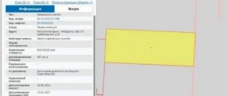
Documents in the cadastral file must be reflected in the public register data and provide the following information about the land allotment:
- number of the plot according to the cadastre;
- actual location (address data);
- size(area);
- information about the permitted type of land use and the category assigned by law;
- text and graphic description of allotment delimitation;
- rights of persons to land allotment;
- qualitative characteristics of the economic profitability of the site;
- information about buildings and structures located within the boundaries of the allotment.
In addition, the date of formation of the land allotment is indicated, which is the date of inclusion of the relevant information in the unified register.
This information must be confirmed by original documents in which they are indicated. But some documents, for example, title documents, can be presented in the cadastral file only as notarized copies.
What is the essence of cadastral business? challenging the cost
23.09.2016
In this article we will look at what is the essence of cadastral business? The cadastral file is part of the documents relating to the land cadastre.
Formation of documents and maintenance of a land property cannot be carried out without a cadastral file.
The cadastral case, based on the practice of its consideration, provides for the following documents, which are interconnected:
- register of the district to which the land of the facility is assigned, the content of which is to conduct mandatory inspections and state registration;
- cadastre plans (duty maps), which describe the land surveying of real estate, types of buildings and the procedure for determining boundaries;
- audit and accounting logs in which information about the cadastral number is entered.
Supporting documents also influence the order of use of the building and its storage:
- accounting journal of documents from the organization’s practice;
- a protocol of results issued and information that can be requested;
- a protocol of formation indicating the boundary distribution of the boundaries of the land plot and the procedure for conducting inspections related to it;
- certificates to the state tax inspectorate, which are provided in cases of request (may be needed when challenging a lawsuit and to determine the results of an inspection of a land plot, as well as its value);
- the content of the results of real estate accounting, which represents federal, municipal or state property;
- summarizing the results of statistical studies;
- generalization of cadastral registration plans (maps);
- other documents that may take into account the boundary distribution of a land plot or building, the procedure for considering which may be necessary when challenging a court case or in other cases.
From practice, a cadastral file is compiled for any property, for example, a private house, the period for checking the cadastral file is about 1 month.
Why do we need a carriage house and construction cabins?
It also contains a protocol for determining the cost and a package of official documents indicating state registration.
The cadastral package provides all types of documents that take into account the boundary formation of a house or building, which may be needed to determine real estate in the classification system, when challenging a decision in the event of jurisdiction of the case.
Components of cadastral affairs
The cadastral file of real estate or land is compiled for a property that involves conducting economic or other activities. The house must have state registration, documents and an inspection protocol for review and determination of the cadastre number from practice.
If a private house consists of several parts, each of which has its own number, then a separate case is opened for each of them.
This rule is necessary to accurately determine the cost of each component of one object. In the event of a merger of parts of a real estate property, the files on its individual elements are liquidated.
From the results of real estate consolidation, a new case is formed in the cadastre from one object or building.
Any cadastral file contains the following package of papers:
- a statement indicating the desire to order a cadastre file and its management;
- a package of papers that are necessary to consider rights to a house, building or other real estate;
- boundary structure to determine the plan and inspection results;
- an act indicating that a boundary determination and the formation of a single object were carried out on the territory of the land plot;
- an extract, which is stored in the state register of cadastres;
- an extract, which is stored in the Unified Register of Rights to Real Estate;
- an extract, which is stored in the inventory bureau and from which you can obtain a calculation of the value of a land plot during an inspection or contestation of a case;
- boundary cadastral business;
- other papers, the essence of which is to classify a building, site or challenge its value.
A quick way to sell an apartment
Requirements for preparation of necessary documents
From legal practice it follows that a large number of positive results of cadastral registration are observed if the applicant promptly provided a complete list of papers, the execution of which is regulated by law.
The land survey is the main paper for the cadastral chamber. Jurisdiction of the case will be excluded in the future when challenged if the documents for the house or buildings are properly drawn up.
It follows from practice that determining a decent price for a house can be achieved using only official papers that do not contain corrections, typos or deletions.
The survey case is supplemented with title papers and applications when the case is contested.
What is the essence of cadastral business? Link to main publication