In order to separate plots belonging to different owners from each other, land surveying is carried out.
Such land works establish the boundaries of each specific plot of land that is privately owned.
To separate lands that are in public use , special red lines are used.
They establish the boundary of a territory that cannot be privatized.
When considering such concepts, there is often confusion. Many people believe that the red line and the border of a land plot are one and the same. In fact, there are a number of significant differences between them.
Concept
The main purpose of the red lines (RL) available on the development scheme is established in paragraph 11 of Article 1 of the Civil Code of the Russian Federation.
The designation was introduced to highlight the boundaries of territories that are intended for general use . Even if the assignment of such a category to land is only in the plans, the contours are still designated in this way.
The boundaries of the following objects are highlighted with red outlines :
- power lines;
- streets;
- squares;
- highways;
- parks;
- communication lines;
- railways;
- areas;
- pipelines.
Since public facilities are already located in the areas limited by the red outline, or their construction is planned in the future, unauthorized land development, as well as going beyond the established boundaries during construction, is strictly prohibited .
Public cadastral map of Russia
A new version of the public cadastral map, released for public use by the summer of 2016, is presented for use.
Using a public cadastral map online is very convenient. At the same time, it is possible to find the necessary information about land plots that are included in Rosreestr at any time. Very often, such information is needed by realtors, lawyers, surveyors and ordinary citizens.
A cadastral map is used when you need to quickly find information about a specific land plot. In addition, the cadastral map allows you to find the necessary information regarding the administrative division of Russia, you can find out where the selected area is located, or determine the department of the register to which it belongs.
What is a cadastral number?
This is a set of numbers that define a specific block, area or area. Determining the cadastral number by referring to the address is quite easy. To do this, you need to find the desired area on the map.
For each of the objects on the cadastral map, the following information is available:• exact area;• address;• cost;• status;• characteristics;• date of registration;
• type of ownership.
If you use the public map of Rosreestr, you can find the right property much faster and easier. All boundaries and adjacent areas are indicated here, which are also included in the register. The desired area can be carefully examined on a digital topographic map and on a satellite image.
Using a cadastral map, you can check the cadastral number of the desired object by address. The map will also be an excellent assistant if you need to determine the cost of a plot by address. To do this, you need to find this area and the necessary information will become available.
Differences from site boundaries
In essence, the red line and the extreme points of the plot are used to achieve one goal - to separate plots from each other .
However, there are significant differences :
- Land intended for public use is marked with red outlines. The boundaries of a land plot indicate the extreme points of ownership owned by a specific person or state.
- Property boundary lines are established during the land surveying procedure, and red lines are established by adopting a regulatory act, for example, a Decision or Decree of the regional or city government.
- The size of the plot changes quite simply, for example, after annexing a neighboring property, or when dividing an existing plot. Red lines, established legally, are indicated on the development plan, and it is difficult to change their location.
- Public lands may be located inside a privatized site, for example, when laying power lines, or cross it. The boundaries of the land plot cannot extend beyond the boundaries of the red lines.
- The establishment of red lines is entirely within the competence of the authorities; they represent a completely independent object of cadastral registration. And the extreme points of the allotment are determined at the request of the owner of the land plot.
On the website of the public cadastral map, what do the thick red lines mean?
Let's get back to the actual terms and meanings of the red lines. Thus, the draft red line has no legally significant force. Conventionally, this is a recommended boundary that allows owners of the right to clarify the boundaries, conduct construction and carry out the process of legitimizing the boundaries of the land plot. At this stage, it is possible to determine the exact boundaries of the allotment before the trial.
The existing boundaries of a land plot have legal coordinate points, that is, legally significant boundaries that cannot be changed without certain actions on the part of government agencies or the owner of the property right. In general, the existing boundaries of the red lines delimit certain territories and areas:
Red lines on the public cadastral map
The public cadastral map displays registered land plots, information about which is contained in the state real estate cadastre. A public cadastral map of land plots was created and posted on the Internet in 2021.
The red line represents the border separating the territory designated for general use from the territory designated for individual land plots for individual use.
The essence of the red line is absolutely the same as the essence of the border of the land plot. But the red line has stronger legal force than the usual land boundary.
What is the seniority of the red line? This line is installed first.
Public cadastral map red lines
The existing boundaries of a land plot have legal coordinate points, that is, legally significant boundaries that cannot be changed without certain actions on the part of government agencies or the owner of the property right. In general, the existing boundaries of the red lines delimit certain territories and areas:
The design red line on the cadastral plan is used only to transfer the configuration of the site on the extract from the urban planning plan, within the limits authorized for use by the owner. Indicates to the owner the boundaries of his property from which to make indents and not to extend the fence beyond the marked red marks.
On the public cadastral map the building is in red
All of the above information is quite important when purchasing, renting, or selling land and real estate in the Moscow region (Moscow region). In addition, you have the opportunity to order a cadastral certificate about the cost, extract, territory plan, as well as a cadastral passport (plot, apartment, premises).
To ensure fire safety, it is allowed to design and construct buildings at an average distance from each other of 6 - 15 meters. The minimum fire safety distance depends on the materials from which the load-bearing external walls and ceilings of neighboring houses are made. State building regulations provide for the required distances between residential buildings:
Kinds
Not all red contours on the territory diagram have the same legal force. There are several types that differ in purpose and significance.
Design
If the construction of facilities or the allocation of territory for public use is only in the plans of the authorities, then a design red line will appear on the development plan.
It means that regional authorities intend to further use the specified territory.
However, such lands have not yet been alienated, which means that such a border has no legal force .
The project line is intended to bring to the attention of the public that in the future the territory will be transferred to the category of public land. However, when this will happen is unknown.
It is possible that the authorities' plan will not be implemented, and the designation will soon disappear from the development plan. Therefore, the project line should not be considered an object subject to cadastral registration .
Typically, designations that have not yet been adopted follow the existing boundaries of the land plot.
Existing
If the objects that need to be separated from the surrounding privatized territories and state property have already been built and are operating, then their boundaries are indicated by the existing red line.
Its consolidation is evidenced by an approved normative act that makes the boundaries legally significant. The exact coordinates of a line of this type are marked on the development plan and recorded in the cadastral registration authorities.
Even if all the plots of land that are located around the territory enclosed in the red outline are officially registered with the Cadastral Chamber and have boundaries established during boundary work, the red line will still be more significant. The extreme points of the plots should not protrude beyond its limits .
Red line on a plot of land in 2021: how to move, meaning
To build a house or any other object, you must obtain permission from the Administration. This even applies to land owners. It would seem that everyone builds wherever they want on their own land. And after construction is completed, they file a lawsuit to legalize the construction. This method is much simpler than visiting various authorities to obtain permission.
If the construction does not interfere with anyone, the neighbors, utility services, or the Administration have no complaints, then the court, of course, will satisfy the claim. But in practice, it happens that the court refuses to legitimize and makes a decision on the demolition or relocation of buildings due to the red lines located.
In the article we will look at what the red line of a land plot means on projects and territory plans, what it affects and what the consequences of violating these lines are.
What is the red line
The first article of the Town Planning Code (hereinafter referred to as the RF GRK) defines red lines (hereinafter referred to as RL).
It is important that the legislator marks with red lines not only existing borders, but also planned ones.
In other words, the KL separates the areas on which public facilities will be or are already located from the rest of the plots for individual use. Public facilities are streets, roads, squares, parks, power lines, pipelines and other similar structures.
In addition to the Civil Code of the Russian Federation, when defining the concept of a red line, it is worth relying on RDS 30-201-98 “Instructions on the procedure for designing and installing red lines in cities and other settlements of the Russian Federation.” It states that CLs are delimited by blocks, microdistricts and other elements of the planning structure from streets, driveways, and squares.
On maps, these lines often cross both public and private land. This phenomenon is called boundary overlap.
Boundary overlap occurs when two adjacent areas intersect. In this case, a dispute may arise between neighbors (read: what to do if a neighbor has seized part of the land?). If the actual boundaries of your plot do not correspond to the data on the cadastral plan, write to our lawyer in the chat on the right. He will tell you how to solve the problem quickly without financial costs.
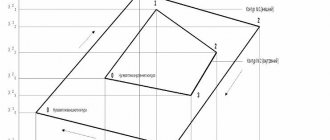
An example of the location of the red lines is provided in the photo below, where you can see that the cable line has a separate area for engineering infrastructure, and in the second picture there is a section for individual development.
As mentioned above, CL highlights not only existing objects, but also those that are only in the planning process. That is, in fact, they exist only on paper. Owners who legalize buildings through the court should remember this.
After all, authorities are not obliged to notify citizens about the planned installation of electrical networks, water supply or gas.
Therefore, when considering petitions and applications from the Administration, the judge relies on the fact that the owners must independently monitor such changes, and leaves the claim without satisfaction.
Remember, every case is unique. Before going to court to legalize a building and starting disputes with local authorities, consult with a lawyer. To do this, write to the chat on the right. A land specialist will answer your questions free of charge and help you find the right solution to your problem.
Regarding the issue of the influence of cable lines, the law states that within these lines it is prohibited to erect capital construction projects, except for those specified in local regulations (for example, monuments).
Also, houses or other buildings must be located at a certain distance from the location of the cable line.
The distance is set in accordance with the Code of Urban Planning Rules and depends on many factors:
- type of construction project;
- wall material;
- type of object behind the red lines (driveway, street, park, water supply, gas, etc.).
There are other calculation features that affect the distance. Therefore, before starting construction, it is important to familiarize yourself with the passage of the cable line and obtain permission “in accordance with all the rules.”
You can see the red lines in almost any document containing a schematic representation of the area. These include:
These documents can be obtained from Rosreestr or from the architecture department of the Administration. An online version of the cadastral map is also available on the Rosreestr website.
Responsibility for violating the red line
When building a house or any other real estate, it is important to pay attention to the CLs and not disturb them. Going beyond such lines always means an administrative offense. And in accordance with the Code of Administrative Offenses of the Russian Federation, Art. 7.
1 such an act is recognized as unauthorized occupation of the territory. In this case, the amount of the fine depends on the cadastral value and category of the offender. It varies from 1 to 3%.
And if the cadastral value has not been determined, and this rarely happens, then from 5,000 to 200,000 rubles.
In practice, red lines can also be located inside the area. For example, a gas pipeline passes through the site. It is strictly forbidden to build even non-capital construction projects over it. Such standards should be observed not only because of fines, but also for safety reasons.
Of course, if construction is planned, then violation of cable lines can be avoided.
But what if the house has been standing for several decades and it turns out that the red line runs through the building, or the fence is outside the border? Courts often encounter similar situations, but not all claims are allowed. The reasons can be very different. However, in some cases it is possible to move or cancel the red line on a land plot.
According to RDS 30-201-98 (Instructions for the design of cable lines), local governments can adjust existing lines.
But this is only possible if the location of the cable line significantly violates the rights of citizens and organizations.
And if a territory has been squatted, then you can rent the occupied territory from the state (read more about how to rent land from the state) or privatize it.
In order to file a claim, you need to collect a lot of documents and pay a state fee. But even in this case, they may refuse to consider the claim. It is possible to get expert advice “here and now” for free. Write to the chat on the right, and a lawyer will answer all your questions and help you write a legally competent statement and prepare for legal disputes.
Arbitrage practice
A positive example of moving the red line and preserving rights to real estate can be the case considered in the Moskovsky District Court of Kaliningrad.
From the case materials it is clear that the plaintiff used the land plot and the house located on it for several years. In 2006, he reconstructed the house and built an attic. Registered ownership of the house and land. However, in 2015 it turned out that the distance from the cable line to the attic was less than 5 meters. And the authorities received a demand to demolish the unauthorized extension.
During the consideration of the case, it turned out that the CL was carried out in 2009. Data from the memory was not taken into account. The plaintiff submitted an application to the Administration to transfer the CL, but was refused.
The plaintiff asked the court to consider the application and retain ownership of the house and extension.
Since the reconstruction was carried out to improve living conditions, does not pose a threat to life and health, and does not violate the rights of third parties, the claim was satisfied.
Source: https://lawowner.ru/nedvizhimost/zemlya/krasnaya-liniya-na-uchastke
Problem situations
Often, even the existing contours of public areas become the object of problems.
However, in each case, a solution can be found and difficulties encountered in determining the location of red lines or other difficulties can be overcome.
Absence of design solutions in the history
Before the introduction of such a concept as the red line, the development of public areas was indicated differently on the plans.
Therefore, it may be absent from the history of design decisions in some urban areas, despite the presence of actual boundaries of public areas.
In such a case, the issue of establishing red lines on the plan can be resolved by developing a special project .
Difficulties with territory planning usually do not arise, since the boundaries of streets and private households are actually reflected on the ground. It is only necessary to transfer them to the plan and highlight the outline of public lands.
It is pointless to draw design lines at the stage of considering a development scheme , since there are actually already significant ones on the ground.
Inconsistency with what actually exists
If the plan shows contours that do not actually correspond to the boundaries of the actual building, changes should be made to the existing scheme .
To do this, coordinates are determined in kind, and in accordance with the information received, changes are made to the cadastral documentation.
Lack of planning documentation
The loss of plans or partial availability of planning schemes, which due to historical prescription are not recognized as legally significant, does not entail the obligation to draw up new documentation and make changes to the design contours.
In fact, building lines exist on the ground and can be reflected in various cadastral registration materials after they have been studied.
Parts of buildings cross the boundaries of public territory
If the facade or other part of the building protrudes beyond the boundaries of public lands, you should refer to the Land Use Rules. The regulations indicate the dimensions of permitted projections of façade parts.
However, it is worth remembering that if the red lines stop buildings that were erected on privatized territories, then based on a court decision, the owners may be forced to demolish the building .
What does the thick red line mean on a public cadastral map?
However, it is also possible to more quickly obtain information about land plots via the Internet - Open Internet sources of information for making real estate transactions.
Currently, on the website of Rosreestr on the portal, by the cadastral number or address of a land plot, you can find out whether a given land plot is properly recorded in the State Property Committee or not.
The National Cadastral Agency intends to present its new development at the XXI International Specialized Forum on Telecommunications, Information and Banking Technologies “TIBO-2014”. I tried to access the cadastral map from a smartphone, a window appears on top of the map data itself, apparently with a license agreement, on which, as I understand, it is necessary to put a consent sign.
What are the red lines on the cadastral plan?
The existing boundaries of a land plot have legal coordinate points, that is, legally significant boundaries that cannot be changed without certain actions on the part of government agencies or the owner of the property right. In general, the existing boundaries of the red lines delimit certain territories and areas:
Let's get back to the actual terms and meanings of the red lines. Thus, the draft red line has no legally significant force. Conventionally, this is a recommended boundary that allows owners of the right to clarify the boundaries, conduct construction and carry out the process of legitimizing the boundaries of the land plot. At this stage, it is possible to determine the exact boundaries of the allotment before the trial.
How to use the public cadastral map
There are even more questions about the “lower” half of Shchelkovskoye Highway (cadastral block 5002, section 76). Plot 76 was registered on the same basis on January 29, 2008; the Federal Law “On the State Real Estate Cadastre” was also not yet in force.
But the main question is that in several places the red line runs along the facades of houses. If these are residential houses, then this means that part of the land plot from the side of the highway was illegally cut off from them, without the knowledge of the owners and without compensation, and that when the highway was expanded, the road some may come close to houses.
This disgrace is often found on other expanded highways.
We recommend reading: Documents for the apartment, list for purchase
On the same map there is also information that is also relevant for residents of Kaloshino - in connection with the expansion of Shchelkovskoye Highway. The thick red line in the middle of the highway is the border between cadastral blocks.
The “upper” (on the map) half of the highway, adjacent to Kaloshino, is cadastral plot No. 29. It is separated from the microdistrict by a thin red line. This is the famous “red line” between a residential neighborhood and the highway.
We dial :29 and read that the site was also previously registered, also registered on 01/01/2007.
Determining the meaning of the red lines on the cadastral plan
The design red line on the cadastral plan is used only to transfer the configuration of the site on the extract from the urban planning plan, within the limits authorized for use by the owner. Indicates to the owner the boundaries of his property from which to make indents and not to extend the fence beyond the marked red marks.
Receipt of documentation for the construction of a capital structure is accompanied by the issuance of a GPZU, the standards of which regulate the use of the allotment for construction. Based on it, the owner can accurately determine the location of each object, since the required indents are made from the red lines, according to established standards.
This is a typical “minimal” site according to Luzhkov. It is illegal because... Article 36 of the Housing Code and the resolution of the Government of the Russian Federation require that plots with landscaping elements, access roads, playgrounds and parking lots be transferred to the owners of premises in the house.
Tverskaya-13 says that free plots in the microdistrict have been allocated for FSB houses. This is a lie (in this case, I blame the editors only for illiteracy, and their source of information for lies). To identify vacant plots, it is necessary to know the boundaries of all adjacent plots in the microdistrict.
Plot owners are interested in: red lines on the cadastral plan - what are they?
Turning to the Town Planning Code of the Russian Federation, we can define that red lines are symbols, the purpose of which is to clarify the boundaries of a land plot between public areas , as well as areas on which communication lines, pipelines, etc. are located.
- A case when an error is made when creating a project, which becomes apparent only after its registration.
- If the structures do not comply with the documents. This often happens due to illegal redevelopment.
- The emergence of new elements. This could be a railway or road, etc.
The red line of the street is
The concept of a street red line has been rooted in urban planning for several centuries now.
This definition is often found today when drawing up documents of title to property or during construction.
Therefore, everyone who decides to engage in construction or register rights to land plots or purchase real estate should understand the essence of the red lines of the street and what they influence.
We recommend reading: What a military pensioner is entitled to
Such territories will only be available for rent. But the land along which the red line runs will not be able to become a property. And it will not be possible to appeal the decision of local authorities. Existing judicial practice has proven this more than once.
Red building line
State standards recommend that objects be located within the exact limits of the red lines. The distance to them should be at least 2 - 3 meters. There are exceptions for some buildings - these are buildings that have premises for public needs on the ground floor. Such objects can be placed directly on this line.
To ensure fire safety, it is allowed to design and construct buildings at an average distance from each other of 6 - 15 meters. The minimum fire safety distance depends on the materials from which the load-bearing external walls and ceilings of neighboring houses are made. State building regulations provide for the required distances between residential buildings:
What is a red line on the land of a private house
The project line (PL in abbreviated form) has no legal force. This is like a diagram that clearly shows the intentions for planning the territory of future development. The marked part of the land, separated by KL, will be further set aside for public and government needs.
For example, the owners of adjacent plots decided to change the location of the boundary of the land separating them. And this is their personal right.
In the event of a revision of the boundaries between lands for individual and public use, the interests of society will be taken into account in the first place.
The basis for changing or adjusting a public facility is planning documentation, which is developed specifically for these purposes.
- Turn on the card without a base by pressing the “no” function in control mode.
- See the map of Russia provided by Rosreestr.
- Look at the map with orthophoto coverage.
- View photographs of the area that were taken from space.
- See the names of geographical features of the territory by selecting the “inscriptions on the map” function.
- With the "none" function, you will have a regular base map without a base.
- Using a large scale of the territory, you can select an object and get acquainted with its cadastral value.
- Also on a large scale map you can find out the type of permitted use of a certain piece of land, its category.
- The relevance of the information entered on the card will also be known.
- Find out about the number of views of a particular district.
Source: https://exjurist.ru/nalogovyj-vychet/chto-oznachaet-zhirnaya-krasnaya-liniya-na-publichnoj-kadastrovoj-karte
Explanations for symbols
10. In accordance with the approved diagrams of the relative location of cadastral quarters and cadastral districts, as well as descriptions of the boundaries of cadastral quarters, cadastral districts, cadastral district, the boundaries of the cadastral division are drawn on the prepared cartographic basis of the duty cadastral map in accordance with accepted conventional signs.
3. Methodological recommendations are used in the preparation of: boundary plans, technical plans, survey reports, public and other cadastral maps, cadastral plans of territories, cadastral passports of capital construction projects, cadastral extracts for land plots, cadastral extracts of capital construction projects, as well as in other cases , which require displaying various cadastral information.
This video is unavailable
Before the examination, Nadezhda told two more amazing facts. From the back side of SNT there is a single-track railway to Krasnozavodsk. And the gas pipeline goes to the fence from the side of the road. And in a strange way, the documents about the laying of this pipe were “lost” by both Avtodor and Russian Railways! When asked, both organizations replied that they could not provide information about both the time and place of laying the pipeline!
On November 30, in the Priozerny SNT, Sergiev Posad district, an examination was carried out to determine the location of the main gas pipeline passing near the border of the dacha village. The story here is quite confusing. SNT itself has existed since 1966, the visiting commission for the allocation of land for the gas pipeline was in June 1966, the land was allocated in September 1966, but the gas pipeline itself, according to old-timers, was installed in 1976. Members of the SNT were offered a long time ago to gasify the village, since the gas passed, according to maps, 250-300 meters from the border, but the summer residents refused. According to summer residents, there were no signs indicating that the pipeline passes here. But in 2021, PJSC Gazprom-Transgaz Nizhny Novgorod filed a lawsuit against SNT members demanding the demolition of all buildings on their sites. A certain number of houses were subject to demolition because they fell into the security zone. Yes, there are, of course, those who couldn’t stand it, but something else is interesting. An oil pipeline runs nearby, and next to them is a cable with its own security zone. So, the cable is the only thing that is currently registered with the cadastral register, except for the SNT itself. According to representatives of SNT, there is no license for the gas pipeline running through, and the Sergiev Posad region does not receive a penny into the budget from the lease of the gas pipeline. The examination was carried out for Nadezhda Dub, whose house was also demolished. It is necessary to measure the distance from the pipe to her house. The invited expert, to his credit, did not make a fuss about the filming and willingly answered questions from everyone present. The measurements were made using a GPS device, which eliminates errors. During the examination, all those present were convinced of the impossibility of deception. Representatives of Gazprom from Vladimir also arrived at the site. It was clear that they did not want to conflict, and also the impression was that they did not go out on such occasions, since they did not take anyone’s position. To ensure the integrity of the examination, the land management expert even offered to go to Krasnozavodsk, the end point of the gas pipeline, to make sure that it was operational. But Nadezhda Dub and Inna Denisova decided that it was enough to dig up the pipe to verify its presence. Representatives of Gazprom walked along the highway with a metal detector, found the point closest to the country houses, and carried out excavations. According to the results of the examination, it was discovered that Nadezhda Dub’s house is located at a distance of 95.8 meters from the highway, that is, it still falls within the zone of minimum permissible distances. True, Gazprom representatives were unable to provide documentation for the route project. And it seems there are reasons for that. Here is a copy of the project, which SNT representatives were somehow able to re-film at one court hearing. The red line indicates the gas pipeline according to information from 1976, the security zone is marked with a red dotted line. It does not go to the village border. But the blue line indicates the gas pipeline according to the state cadastre in 2021. Look how the boundaries of the security zone, marked in yellow, have extended to the dacha plots, the boundary of which is shown in green! It turns out that the pipe was laid with deviations from the design! And the authorities, according to other representatives of the village, in the 70s “calmed down” the summer residents, saying that, they say, everyone’s pipe runs so close and it’s okay! Since the court ordered only a land management examination, and the experts refused to check the pipeline pressure gauges at the nearest gas distribution station, citing the absence of such an application from the court, the pensioners themselves went to the gas distribution station. Having made sure that there was still pressure, they went to think further about their further actions.
This is interesting: It is not legal to write off a non-fiscal check