Amnesty for land surveying is the name of the process of legalizing the rights of ownership of real estate .
In particular, this applies to dacha land plots that were received before the law on registration of land rights came into force.
Using this procedure, it is possible to register ownership of a territory with a minimum of documents and without carrying out geodetic work.
However, given recent changes in land legislation, the relevance of this concept is in doubt.
Purposes of the law
At the end of the 90s, a separate category of land arose in Russia, the form of ownership of which was problematic to establish. At the same time, in some areas structures were erected, in others – buildings were already listed on the plans.
In order to systematize such situations and bring them into line with legal guidelines, Federal Law No. 93-FZ “On Dacha Amnesty” was adopted in 2006.
This act had two main goals:
First of all,
to simplify the process of registering ownership rights to certain types of property .
Including plots acquired before the Land Code of the Russian Federation came into force (before October 20, 2001). To achieve this goal, the need to obtain permission from local authorities was excluded from the registration procedure.
Thus, a citizen has the right , bypassing secondary authorities, directly contact the service that registers land rights with an application for legalization of property on the basis of a supporting document.
As for the second goal, it is to reduce the cost of registration of rights . Thus, according to standard regulations, owners of land plots for registration are required to carry out land surveying in a timely manner to bring data on the boundaries of the plot and its size into line.
However, the dacha amnesty presupposes the optionality of such measures , since the lack of information about the characteristics of the land cannot be considered a sufficient reason for refusing state registration.
A ban on the disposal of land plots (sale, gift, inheritance) from January 1, 2021, the survey of which has not been carried out, even in the case of an existing certificate of ownership.
From January 1, 2021, Russia will impose a ban on the disposal of land plots whose boundaries are not specified. This provision was approved by Decree of the Government of the Russian Federation dated December 1, 2012 No. 2236-r on the Action Plan (“road map”) “Improving the quality of public services in the field of state cadastral registration of real estate and state registration of rights to real estate and transactions with it.” Paragraph 21 of Section 2 of the “road map” defines the following: “Establishing, from January 1, 2021, a ban (without exceptions) on the disposal of land plots for which there is no information about the location of the borders.” Thus, if cadastral work in relation to a land plot is not carried out in accordance with the procedure established by law before 01/01/2018, then such a plot cannot be disposed of (sold, donated, exchanged, etc.) regardless of whether there is a certificate of title ownership, state act on land or not. Land plots registered in the cadastral register without land surveying are considered previously registered. Land users of such land plots will need to carry out cadastral work to clarify the location of the boundaries and area of the land plots. Then send the boundary plan to the cadastral registration authority to make clarifications in the state real estate cadastre. Cadastral work is carried out by cadastral engineers on a paid basis. Since this procedure is quite expensive, many site users ignore it. However, this state of affairs is far from meeting the true benefits of both owners and tenants. In order to really understand how relevant land surveying is in each individual case, this issue needs to be understood in more detail. Why are you forced to do land surveying today? The law on compulsory land surveying, which states that starting from 2021, it will be possible to dispose by right, including conducting various transactions, with plots (sale, donation), the documentation of which will not have boundary marks, was proposed back in 2012. It cannot be said that recently the number of people wishing to carry out land surveying has increased significantly; there are few who have realized the need to establish the boundaries of their land plots. Surely, the main influx of people wishing to carry out land surveying will occur at the end of 2017, when land owners begin to realize that they will not be able to sell, exchange, or donate their land. In this case, it does not matter at all whether they have title documents or not, and moreover, during this time the owner of the site may need to carry out certain construction work on it. It will not be possible to formalize buildings erected on plots without a boundary plan.
Who can benefit
This opportunity is also available to persons :
- whose rights have already been entered into the appropriate register;
- having shares in agricultural lands;
- re-registering the right of perpetual possession to another type of right.
Additionally, the legislator determined that if a citizen expands property at the expense of state lands by redistributing them in a regulated manner, then clarifying the boundaries of the site is not considered necessary.
received land for use before 2001
can count on a simplified procedure .
There are no restrictions on categories of population - it is enough to collect title and other documents to submit them to the registration structures.
According to recent changes in legislation, partnerships can also take advantage of this right.
You need to understand that the activities of cadastral engineers are non-departmental, therefore the cost of their services for land surveying is not regulated by the Government of the Russian Federation.
Land surveying until 2021: Government order
In accordance with the order of the Russian Federation No. 2236-r, the adoption of which is directly aimed at improving the quality of services provided for cadastral registration and land surveying (the legislative act can be downloaded here ), which came into force back in 2012, the owners of each land plot were assigned before the fact of the need to complete the procedure for determining the lines of land boundaries by 2021.
If this requirement is not met, starting from March 2021, citizens will not be able to use their right to dispose of the land by concluding various transactions (related to donation or sale), unless the documents for the land contain a corresponding mark on the current land boundaries.
Today, there is practically no increase in the number of citizens who would initiate the process of fixing the boundaries of their plots, when compared with last year.
On the contrary, one gets the feeling that landowners are simply waiting. Few among them understood how important and truly necessary the determination of the boundaries of plots is.
Price
There is an approved mechanism for determining the price for work of this nature, but for the most part it is followed only by municipal services, whose execution speed is far from ideal.
When setting payments, private companies are guided by current indicators.
For example, the cost of land surveying is affected by :
- region of residence;
- category of land;
- square;
- location and shape of the site.
Therefore, the applicant is recommended to consider several companies , comparing reviews of former clients and approved figures.
So, in the Moscow region the price varies from 10 thousand rubles to 30 thousand rubles. Whereas in the neighboring region, the Leningrad region, the cost is much lower - within 7-8 thousand rubles. In other territories, this value is on average within 5 thousand rubles.
Free conduct
As for carrying out the land surveying procedure free of charge, this is only possible within the framework of complex cadastral activities. In such cases, all work is carried out at the expense of budget funds.
municipal structures can initiate the program . They are also responsible for the results of the process.
Interested parties are advised to carefully study all the intricacies of the procedure, since free land surveying was introduced relatively recently and has significant features.
Documents and the need for land surveying
To take advantage of the opportunity to register country real estate for use, you will need to collect a package of the following documents :
- statement;
- passport of a citizen of the Russian Federation;
- receipt of payment of state duty;
- technical plan (both for the land and for existing structures);
- title papers.
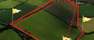
To obtain a plan, it is necessary to carry out land surveying.
To do this, it is important for a citizen to know how this procedure is carried out :
- Order the appropriate work from the cadastral organization.
- After clarifying the points with date and time, the engineer takes measurements of the site and identifies the coordinates of its location.
- Based on the information received, the specialist draws up a technical plan.
Only with the document in hand can you contact the registration authorities to legitimize your rights.
New land surveying until 2018
That is, with the onset of 2021, no one will be able to dispose of their right to use a land plot if land surveying is not organized before the specified time.
If surveying is not carried out using modern satellite navigation tools and the specific boundaries of a plot of land are not determined, it will become impossible to register the transfer of ownership of such land through Rosreestr, regardless of the legal grounds for doing so.
Why is land surveying necessary?
Read how to survey a plot of land here.
How to challenge the results of land surveying, read the link:
Consequently, neither the buyer nor the heir will be able to issue the certificate they are entitled to confirming their right to the land plot. In addition, the procedure for donating a plot of land will become impossible.
The indicated procedure is regulated by government decree No. 2236-r, adopted on December 1, 2012.
The purpose of adopting such a document is to implement a long-term action plan aimed at improving the quality of services provided in the field of registration of rights to real estate and state cadastral registration.
Starting in 2021, the adopted federal law related to state land cadastral registration will gain legal force.
What to do with land plots not demarcated by 2021?
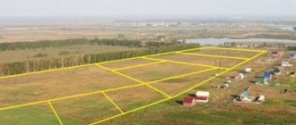
Before carrying out a transaction with a plot, it will still be necessary to survey the property, coordinate the boundary lines with the owners of neighboring plots, and also make appropriate changes to the cadastre - to create a cadastral record of land data.
If cases arise where boundaries that were previously drawn by mistake are superimposed on the cadastral electronic map, the issue will need to be resolved through the court.
That is, in this situation, the transaction execution procedure will have characteristic unpredictability, including in relation to timing and costs incurred.
Under such extreme conditions, it will be very difficult to find a buyer for the land. The only way out of this situation will be to carry out land surveying with coordination of boundary lines and organize a registration procedure.
Only having a new cadastral passport in hand, with a plot that has been completely surveyed and thus prepared for alienation, can you search for potential buyers.
The task of global land surveying of all land holdings by 2021 is extremely unrealistic, due to its volume for the entire list of cadastral engineers.
But even taking this fact into account, the demand for land surveying still remains almost at the same level.
Probably, most owners will begin to carry out land surveying when the issue becomes clearly urgent, which will entail quite understandable significant financial costs and excessive haste.
Already according to today's forecasts, the peak of requests for cadastral services will occur directly at the end of 2021, which will cause mass unrest among citizens.
Until what year is it extended?
According to the initial assurances of the Government of the Russian Federation, from January 1, 2021, the dacha amnesty will no longer be used. However, further consideration of the issue led to the fact that the simplified procedure for registering property rights was extended until March 2021 .
But certain March amendments to the amnesty law significantly influenced the process itself. For example, it is now mandatory to carry out land surveying, which will increase both the cost of obtaining title documents and the time that will need to be spent on all actions.
Description of Federal Law 477: changes to the law on mandatory land surveying
Until 2021, land surveying was an optional procedure. Owners of land plots could set boundaries almost at their own discretion. From January 1, 2021, Law 477 Federal Law provides for restrictions for negligent owners.
Amendments to the federal law will come into force on January 1, 2018. The following real estate properties fall under its scope:
- horticultural lands;
- country farms;
- plots for individual construction;
- land for vegetable gardens.
Owners of land plots are required to enter their possessions into the unified state register.
Otherwise, they will not be able to sell, lease or donate their lands. The changes will affect private land holdings:
- Received from state reserves for permanent use.
- Falling under distribution due to various reasons.
- Requiring division or unification.
Changes in the law affected the land surveying procedure itself and increased prices for this service. In 2021, registering land with the cadastral register was quite simple. To do this, it was necessary to submit an application to the registration authorities. The boundaries were determined according to old cadastral plans. Lands were entered into the register almost automatically.
From January 1, 2021, the owner is obliged to independently order cadastral work. Only after following all procedures and entering the property into the unified cadastral register, the owner of the land will be able to fully manage his plot.
It will be impossible to transfer land property by inheritance if it is not included in the unified cadastre. The heirs will be able to divide the plot only if the points characterizing the boundaries of the land plot are included in the State Property Code.
IMPORTANT: Before calling specialists to your site, you must make sure that the organization performing cadastral work has the right to engage in this activity. Company employees must have appropriate certificates, as well as certificates to carry out work. The equipment must also be calibrated and certified.