The procedure for registering a land plot and registering it as ownership is quite confusing. It will be even more difficult for the owner if he does not have a whole plot, but a part - a share. It is necessary to first allocate a share, legitimize it as a new property, and establish boundaries. The last step is to establish ownership of the allocated part. We recommend that you seek help from a lawyer, because... here it is important not only to prepare the paperwork correctly, but also to find a licensed and accredited expert to divide the land.
Grounds for registration of ownership
The procedure for registering land ownership is regulated by the legislation of the Russian Federation. Depending on the basis for the emergence of the right, the procedure for registering a plot may differ.
The legislation provides for the following grounds for obtaining land ownership:
- privatization;
- inheritance;
- donation or purchase and sale;
- court decision, decree.
The land plot can be registered as sole, joint or shared ownership.
Sole proprietorship means one owner.
Joint ownership is the simultaneous use and disposal of real estate by several legal owners, for example, spouses.
Shared ownership is the presence of several owners of real estate, conditionally divided into shares.
Land ownership - what the law says
The division of shares is carried out either by agreement of the parties or in a court hearing. The fundamental principles of shared ownership are set out in Art. 244 Civil Code of the Russian Federation. Real estate - namely, a plot of land owned by several owners - is registered as common property. When the specific size of the share of each owner is clearly defined, the property is recognized as shared property. If the ratio of shares is not distributed - joint.
The legislator explains that in some cases listed by law, jointly owned property cannot be divided between the owners. If real estate is not indivisible, shared ownership may be established on it.
What lands cannot be registered as property?
The legislation provides for the division of land plots according to their purpose into the following categories:
- lands of populated areas;
- agricultural;
- specially protected objects and territories;
- areas of forest and water resources;
- defense lands;
- for industrial purposes.
At the same time, it is impossible to obtain ownership of special-purpose land plots withdrawn from circulation.
These areas include:
- park areas;
- cemeteries;
- nature reserves;
- lands with objects of strategic importance located on them (for example, areas under nuclear power plants and those on which objects of the armed forces of the Russian Federation are located).
Registration of ownership rights to a land plot
After preparing a set of proper documentation, go to the MFC or Rosreestr to submit an application. Remember that it is easier to do this through a multifunctional center, since it is this body that is aimed at providing professional public services. In addition, there is an electronic queue and SMS notifications, as well as high service and the work of experienced specialists.
Please keep in mind that the MFC takes two days longer to prepare documents. This is due to the fact that submitted papers are accepted here and then forwarded to Rosreestr. Nevertheless, today multifunctional centers are becoming increasingly popular.
How to register a plot of land as a property?
How to register land ownership without documents, read here.
How to register ownership of a land plot under a will, read the link:
Documents required to register land ownership
To register land ownership, the following documents will be required:
- title document;
- receipt of payment of state duty;
- cadastral plan of the site;
- application for state registration of property rights;
- passport or other document confirming the identity of the applicant.
In this case, the title documents mean the following papers:
- certificate of acceptance of inheritance or ownership;
- order to allocate a plot of land;
- resolution on the provision of land;
- land purchase and sale agreement or gift agreement;
- court decision, etc.
The cadastral plan of a land plot reflects its main characteristics. This plan is drawn up when the site is registered and assigned a cadastral number.
Without a cadastral passport, it is impossible to carry out any transaction with land.
To obtain a cadastral passport, you must submit a corresponding application to the Federal Cadastral Service.
This document has no set expiration date. It is considered valid as long as the information specified in it remains relevant.
The cadastral passport also indicates the cadastral value - this is the amount of the state assessment of the site in monetary terms. This assessment is made taking into account many parameters: location, purpose, area of the site, etc.
Property tax is also charged on the cadastral value.
You can find out the estimated cost of the plot by contacting the Cadastral Chamber.
Sometimes situations occur when the cadastral amount exceeds the market value of the land. In this case, it is possible to challenge the state assessment.
The cadastral value of land plots is regularly revalued by government agencies.
How to allocate a share of a plot
Any owner of land real estate has the right to allocate and register ownership of his share of the common plot. It is necessary to make sure that there is no legislative ban on the allocation; none of the newly formed parts will lose their economic characteristics. If such restrictions exist, the owner of the share may qualify for monetary compensation.
Minimum sizes of land plots can be requested from territorial or municipal committees for urban construction. Indicators cannot be less than those approved by federal standards:
- 4 acres for subsidiary/dacha farming;
- 6 acres for agricultural land and for building a house, except in cases of organizing farms;
- 20 acres for agricultural business.
It is necessary to check and correctly execute the documentation establishing ownership of the divided plot of land. You also need to find out whether it is registered in the cadastral register. Before the division procedure, put the papers in order, set the boundaries of the allotment if there are none.
The allocation of a share from the common property is carried out by agreement with the remaining owners. When a share or shares are allocated, two or more new ones are formed in place of one section. In this case, the land plot from which the part was allocated is retained; it must be formalized within the changed boundaries. If all owners agree with the allocation of shares, it is necessary to determine the boundaries and location of the newly formed plots.
There is no need to confuse selection and section. When property is divided, completely new land objects are formed. They need to be re-registered and assigned numbers. The old divided site ceases to exist. Only a single owner can divide an object - for example, if he decided to divide his land plot into several in order to sell them, donate them, etc. He continues to be the owner of the formed parts until he disposes of them.
If the owner owns part of the land, we can only talk about allocating it in kind. In this case, the allocated plot of land is re-registered as a property, and the old one remains within the specified boundaries.
To summarize:
- division - one property owner divides his land into several parts, remaining their owner;
- allotment - several owners of one land plot allocate their shares.
If the co-owners are not ready to resolve this issue peacefully, the dispute over division is referred to the court.
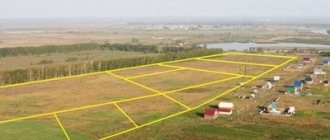
Carrying out topographic survey of the site and its surveying
Controversial situations often arise when determining the boundaries of a plot of land . This problem is especially relevant for summer residents.
To resolve a controversial situation, land surveying is carried out. Most often, land surveying is used to determine the boundaries of new areas.
This procedure is a certain set of works, including establishing, securing, and, if necessary, restoring the boundaries of a land plot.
In addition, land surveying helps to legitimize the actually used area of the land plot. In this case, when carrying out this procedure, the actual area of the site is indicated, and not stated in the documents.
Such an increase in land is possible only in agreement with neighbors and within the limits established by local governments (in practice, an increase in area is allowed by no more than 10% , or up to six hundred square meters ).
Land surveying is also necessary in the case of dividing one plot into two or more and in the case of merging (purchasing) adjacent plots of land.
In many cases, the need for land surveying is due to a more serious problem. Often, old title documents for land do not indicate clear boundaries of the plot, but only its exact size.
In this situation, the owner cannot prove his rights to the occupied land. If a controversial situation arises, he can, perhaps, provide the judicial authorities with a topographical survey of the site along its borders.
Topographic survey is a set of activities aimed at measuring the earth's surface and drawing up a map of a site or area.
Topographic survey of the site is necessary for the following purposes:
- development of a territory planning project;
- purchase (lease, privatization) of a site;
- gas pipeline laying.
The following objects are displayed on the land survey plan:
- buildings (including structures, structures);
- fencing;
- roads;
- communications;
- vegetation.
If land surveying was not carried out on the land as part of the pre-sale preparation, then not a single transaction with it will be registered with government agencies.
In this case, a corresponding entry is made in the cadastral passport about the owner’s refusal to carry out land surveying .
Land surveying and topographic surveys are carried out by geodetic companies.
Division of the plot by agreement of the parties
If the parties agree with the division or allocation, it is necessary to invite a cadastral engineer to agree on new perimeters. The specialist will develop a land survey plan and document the location of their boundaries. The project must be agreed upon and approved by all participants in the section. To do this, the cadastral specialist is obliged to ensure that all property owners can familiarize themselves with the project.
It is also permissible to make clarifications or suggestions for improvement. The cadastral engineer informs the owners in advance about the place and time of approval of the land surveying project. A month must pass from the date of notification. If during this time no objections are received regarding the land boundaries and location of the formed plots, the project is considered approved.
Based on the approved land surveying project, a cadastral engineer travels to the area and carries out the removal of plot boundaries “in situ”. Boundary signs are placed on the plots, which are registered by an engineer and entered into cadastral records. The owners are given a deed indicating the exact coordinates of the boundary markers.
The engineer duplicates the finished reorganization plan in electronic form for transmission to Rosreestr. Also, information about changes is entered into the territorial land management authorities. The paper version of the plan is handed over to the owners of the land plots along with the act of coordinating the boundaries with the neighbors.
Next, it is necessary to draw up a division agreement with all owners. The document will indicate:
- data of all owners;
- address and cadastral number of the land plot;
- consent to division;
- indication of the method of division;
- financial obligations of each party.
To register the land formed from the share in the cadastral register, you need to submit an application to the local land committee or the city construction department. The application is accompanied by a land survey document, ownership of a share in the divided property, a cadastral passport and a division agreement.
The result of consideration of the application will be new postal addresses assigned to the newly received sites. The following is the procedure for legitimizing the formed plots and registering them as property.
To register a new land plot with Rosreestr, the owner of the share submits an application with a request to deregister the old one in connection with its reorganization. It can be done:
- in the state institution “My Documents” - MFC;
- on the State Services portal;
- by personally contacting the territorial department;
- by mail.
At the same time, the need to register the newly formed land plot should be indicated. The following documents are attached to the application:
- certificate of ownership of the share of the old site;
- land surveying;
- consent of the owners of the old plot to the division;
- passports.
New shares are assigned cadastral numbers. The owners will receive an extract from the Unified State Register of Real Estate on the registration of the land plot. After the legalization procedure, you can contact Rosreestr at the location of the site or via the Internet for a cadastral passport.
Directly from the territorial department you will receive the original document with all the necessary stamps and signatures. If you order a document on the website or by mail, be prepared to have copies certified by a notary.
Terms and cost of registration
Registration of a land plot is a lengthy procedure, since for this it is first necessary to survey the site and obtain a cadastral plan.
If all the necessary documents are ready for state registration, then the procedure itself will take only 7 working days .
When submitting documents for state registration to the Cadastral Chamber, the amount of state duty does not exceed 1,000 rubles for individuals and 15,000 rubles for organizations.
Registration of a land plot with buildings
If you have a certificate of ownership of a private house, you can buy the land plot on which the house is located. In this case, you need to pay only 2% of the cadastral value of the plot .
To do this, you must send an application to the Department of Property Relations indicating the following data: number of the state registration certificate and inventory number. A copy of the owner's passport is attached to the application.
Within a month, the department issues an order to provide ownership of this land.
In case of inheritance of a house, privatization of the plot under it is possible in a simplified manner if there are any documents for the land.
If there are no documents left for the land, then the plot must be purchased .
In this case, you will need to contact the local administration for a site layout diagram. After this, you need to obtain its cadastral plan. All these documents must be submitted to the local government and wait for a decision to be made on the provision of the site.
In the process of contacting the local administration, it may turn out that the land with the building located on it has been withdrawn from circulation, that is, it is included in the category of land plots that are prohibited for purchase by the current legislation of the Russian Federation. In this case, it is not possible to obtain ownership of the land.
Which land plots are not subject to division?
Land objects are recognized as indivisible if, after division:
- lose statutory application;
- become impossible to use;
- are less than the area permitted by law.
For example, the land is intended for agricultural work or housing construction. On the shares of the plot formed after the division there should also be an opportunity to build a house or engage in agriculture/farming. A separate convenient passage must be organized for each landholding. Each newly formed plot must meet sanitary and fire safety requirements.
The area of new plots after division cannot be less than legally established for land plots. Land use rules and minimum land holdings are regulated by local authorities.